805:"}},"text\/plain":{"en":{"":"coordinates of the point of view"}}},"{\"value\":{\"latitude\":52.268731,\"longitude\":0.211325,\"altitude\":null,\"precision\":1.0e-6,\"globe\":\"http:\\\/\\\/www.wikidata.org\\\/entity\\\/Q2\"},\"type\":\"globecoordinate\"}":{"text\/html":{"en":{"P1259":"52\u00b016'7.432"N, 0\u00b012'40.770"E"}},"text\/plain":{"en":{"P1259":"52\u00b016'7.432\"N, 0\u00b012'40.770\"E"}}},"{\"value\":{\"entity-type\":\"property\",\"numeric-id\":7787,\"id\":\"P7787\"},\"type\":\"wikibase-entityid\"}":{"text\/html":{"en":{"":"
131:
648:"}},"text\/plain":{"en":{"":"inception"}}},"{\"value\":{\"time\":\"+2008-07-26T00:00:00Z\",\"timezone\":0,\"before\":0,\"after\":0,\"precision\":11,\"calendarmodel\":\"http:\\\/\\\/www.wikidata.org\\\/entity\\\/Q1985727\"},\"type\":\"time\"}":{"text\/html":{"en":{"P571":"26 July 2008"}},"text\/plain":{"en":{"P571":"26 July 2008"}}}}": -->
682:
449:
801:
264:
285:
323:
328:
67:
469:"}},"text\/plain":{"en":{"P2699":"https:\/\/www.geograph.org.uk\/profile\/26976"}}},"{\"value\":{\"entity-type\":\"property\",\"numeric-id\":2093,\"id\":\"P2093\"},\"type\":\"wikibase-entityid\"}":{"text\/html":{"en":{"":"
698:"}},"text\/plain":{"en":{"P973":"https:\/\/www.geograph.org.uk\/photo\/897492"}}},"{\"value\":{\"entity-type\":\"property\",\"numeric-id\":7384,\"id\":\"P7384\"},\"type\":\"wikibase-entityid\"}":{"text\/html":{"en":{"":"
690:"}},"text\/plain":{"en":{"P7482":"file available on the internet"}}},"{\"value\":{\"entity-type\":\"property\",\"numeric-id\":973,\"id\":\"P973\"},\"type\":\"wikibase-entityid\"}":{"text\/html":{"en":{"":"
457:"}},"text\/plain":{"en":{"":"object of statement has role"}}},"{\"value\":{\"entity-type\":\"item\",\"numeric-id\":33231,\"id\":\"Q33231\"},\"type\":\"wikibase-entityid\"}":{"text\/html":{"en":{"P3831":"
473:"}},"text\/plain":{"en":{"":"author name string"}}},"{\"value\":\"R J Noble\",\"type\":\"string\"}":{"text\/html":{"en":{"P2093":"R J Noble"}},"text\/plain":{"en":{"P2093":"R J Noble"}}}}": -->
604:"}},"text\/plain":{"en":{"":"copyright license"}}},"{\"value\":{\"entity-type\":\"item\",\"numeric-id\":19068220,\"id\":\"Q19068220\"},\"type\":\"wikibase-entityid\"}":{"text\/html":{"en":{"P275":"
560:"}},"text\/plain":{"en":{"":"copyright status"}}},"{\"value\":{\"entity-type\":\"item\",\"numeric-id\":50423863,\"id\":\"Q50423863\"},\"type\":\"wikibase-entityid\"}":{"text\/html":{"en":{"P6216":"
686:"}},"text\/plain":{"en":{"":"source of file"}}},"{\"value\":{\"entity-type\":\"item\",\"numeric-id\":74228490,\"id\":\"Q74228490\"},\"type\":\"wikibase-entityid\"}":{"text\/html":{"en":{"P7482":"
461:"}},"text\/plain":{"en":{"P3831":"photographer"}}},"{\"value\":{\"entity-type\":\"property\",\"numeric-id\":2699,\"id\":\"P2699\"},\"type\":\"wikibase-entityid\"}":{"text\/html":{"en":{"":"
710:"}},"text\/plain":{"en":{"":"operator"}}},"{\"value\":{\"entity-type\":\"item\",\"numeric-id\":1503119,\"id\":\"Q1503119\"},\"type\":\"wikibase-entityid\"}":{"text\/html":{"en":{"P137":"
809:"}},"text\/plain":{"en":{"":"heading"}}},"{\"value\":{\"amount\":\"+45\",\"unit\":\"http:\\\/\\\/www.wikidata.org\\\/entity\\\/Q28390\"},\"type\":\"quantity\"}":{"text\/html":{"en":{"P7787":"45
706:"}},"text\/plain":{"en":{"P7384":"897492"}}},"{\"value\":{\"entity-type\":\"property\",\"numeric-id\":137,\"id\":\"P137\"},\"type\":\"wikibase-entityid\"}":{"text\/html":{"en":{"":"
453:"}},"text\/plain":{"en":{"":"creator"}}},"{\"value\":{\"entity-type\":\"property\",\"numeric-id\":3831,\"id\":\"P3831\"},\"type\":\"wikibase-entityid\"}":{"text\/html":{"en":{"":"
556:
694:"}},"text\/plain":{"en":{"":"described at URL"}}},"{\"value\":\"https:\\\/\\\/www.geograph.org.uk\\\/photo\\\/897492\",\"type\":\"string\"}":{"text\/html":{"en":{"P973":"
911:
465:"}},"text\/plain":{"en":{"":"URL"}}},"{\"value\":\"https:\\\/\\\/www.geograph.org.uk\\\/profile\\\/26976\",\"type\":\"string\"}":{"text\/html":{"en":{"P2699":"
702:"}},"text\/plain":{"en":{"":"geograph.org.uk image ID"}}},"{\"value\":\"897492\",\"type\":\"string\"}":{"text\/html":{"en":{"P7384":"
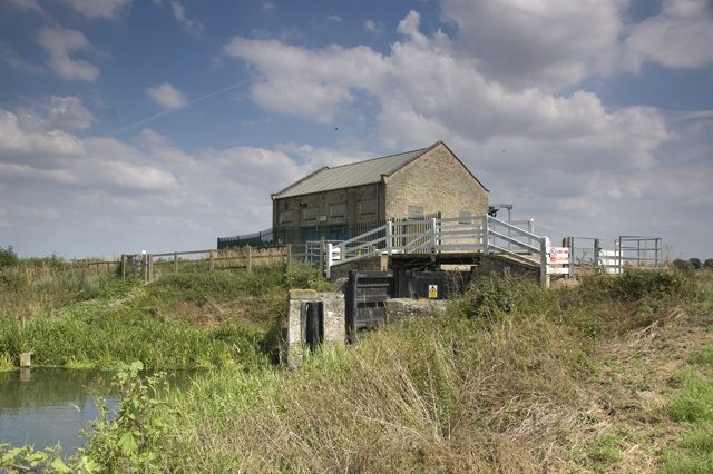
958:{{Information |Description={{en|1=Pumping station and flood gates at the head of Bottisham Lode, Cambridgeshire, England}} |Source=Geograph |Author=R J Noble |Date= |Permission= |other_versions= }} == Summary == {{Information |Description=Lock at the head
38:
375:– You must give appropriate credit, provide a link to the license, and indicate if changes were made. You may do so in any reasonable manner, but not in any way that suggests the licensor endorses you or your use.
247:
233:
703:
687:
605:
561:
711:
458:
806:
802:
699:
683:
557:
470:
462:
454:
466:
707:
695:
691:
645:
601:
450:
608:"}},"text\/plain":{"en":{"P275":"Creative Commons Attribution-ShareAlike 2.0 Generic"}}}}": -->
211:
78:
737:
631:
587:
257:
130:
46:
787:
292:
977:
382:
514:
847:
820:
765:
721:
571:
537:
522:
507:
780:
750:
655:
615:
480:
439:
940:
935:
714:"}},"text\/plain":{"en":{"P137":"Geograph Britain and Ireland"}}}}": -->
338:
381:– If you remix, transform, or build upon the material, you must distribute your contributions under the
299:
on the
Geograph website for the photographer's contact details. The copyright on this image is owned by
564:"}},"text\/plain":{"en":{"P6216":"copyrighted"}}}}": -->
968:
The following pages on the
English Knowledge use this file (pages on other projects are not listed):
813:"}},"text\/plain":{"en":{"P7787":"45 degree"}}}}": -->
86:
910:
905:
529:
37:
972:
772:
757:
335:
8:
279:
263:
116:
Pumping station and flood gates at the head of
Bottisham Lode, Cambridgeshire, England
951:
921:
304:
73:
429:
200:
190:
830:
731:
665:
625:
581:
490:
284:
296:
878:
Click on a date/time to view the file as it appeared at that time.
1000:
249:
234:
52° 16′ 07.43″ N, 0° 12′ 40.77″ E
995:
179:
125:
61:
423:
Add a one-line explanation of what this file represents
1010:
966:
986:
876:
218:
Creative
Commons Attribution Share-alike license 2.0
85:
Commons is a freely licensed media file repository.
632:
Creative
Commons Attribution-ShareAlike 2.0 Generic
606:
Creative
Commons Attribution-ShareAlike 2.0 Generic
51:(640 × 426 pixels, file size: 124 KB, MIME type:
392:https://creativecommons.org/licenses/by-sa/2.0
66:
467:https:\/\/www.geograph.org.uk\/profile\/26976
398:Creative Commons Attribution-Share Alike 2.0
316:
206:
175:
164:
121:
103:
696:https:\/\/www.geograph.org.uk\/photo\/897492
196:
185:
145:
137:
14:
810:
358:– to copy, distribute and transmit the work
129:
988:The following other wikis use this file:
530:https://www.geograph.org.uk/profile/26976
758:https://www.geograph.org.uk/photo/897492
256:View this and other nearby images on:
97:
978:User:Stinglehammer/List of UK canals
303:and is licensed for reuse under the
224:
869:
339:Attribution-Share Alike 2.0 Generic
327:
322:
307:Attribution-ShareAlike 2.0 license.
13:
428:
422:
313:
290:
171:Lock at the head of Bottisham Lode
110:
98:
44:
1024:
427:
967:
821:coordinates of the point of view
803:coordinates of the point of view
413:
369:Under the following conditions:
334:This file is licensed under the
326:
321:
315:
283:
262:
248:
240:
65:
31:
21:
410:
111:
41:No higher resolution available.
983:
873:
738:file available on the internet
688:file available on the internet
409:
291:This image was taken from the
26:
1:
963:
836:52°16'7.432"N, 0°12'40.770"E
788:Geograph Britain and Ireland
712:Geograph Britain and Ireland
508:object of statement has role
455:object of statement has role
435:Items portrayed in this file
275:
7:
239:
10:
1029:
1007:Usage on www.wikidata.org
992:Usage on de.wikipedia.org
383:same or compatible license
167:Head of Bottisham Lode.jpg
161:
156:
106:Head of Bottisham Lode.jpg
100:
47:Head_of_Bottisham_Lode.jpg
870:
16:
766:geograph.org.uk image ID
700:geograph.org.uk image ID
412:
349:
72:This is a file from the
36:
957:
927:
178:
124:
76:. Information from its
297:this photograph's page
268:52.268731; 0.211325
79:description page there
1001:Cambridgeshire Lodes
973:Cambridgeshire Lodes
906:20:49, 31 July 2009
364:– to adapt the work
936:15:40, 30 May 2009
928:Correct resolution
538:author name string
471:author name string
984:Global file usage
961:
812:
616:copyright license
602:copyright license
421:
312:
311:
295:collection. See
273:
272:
222:
221:
215:
212:Reusing this file
153:
152:
94:
93:
74:Wikimedia Commons
32:Global file usage
1020:
948:
918:
880:
858:
857:
852:
790:
785:
775:
770:
760:
755:
751:described at URL
692:described at URL
572:copyright status
558:copyright status
545:
542:
532:
527:
517:
512:
419:
405:
402:
399:
396:
393:
385:as the original.
347:
336:Creative Commons
330:
329:
325:
324:
319:
318:
305:Creative Commons
293:Geograph project
287:
280:
269:
266:
252:
251:
245:
244:
243:
237:
236:
225:
209:
181:
168:
162:
133:
127:
115:
107:
101:
90:
69:
68:
62:
56:
54:
1028:
1027:
1023:
1022:
1021:
1019:
1018:
1017:
982:
969:
962:
954:
946:
924:
916:
872:
871:
868:
867:
866:
865:
864:
863:
862:
861:
860:
859:
855:
853:
850:
841:
840:
839:
837:
827:
826:
825:
823:
800:
799:
798:
797:
796:
795:
794:
793:
792:
791:
786:
783:
777:
776:
771:
768:
762:
761:
756:
753:
744:
743:
742:
740:
728:
727:
726:
724:
681:
680:
679:
678:
677:
676:
675:
674:
672:
662:
661:
660:
658:
643:
642:
641:
640:
639:
638:
637:
636:
634:
622:
621:
620:
618:
599:
598:
597:
596:
595:
594:
593:
592:
590:
578:
577:
576:
574:
555:
554:
553:
552:
551:
550:
549:
548:
547:
546:
543:
540:
534:
533:
528:
525:
519:
518:
513:
510:
501:
500:
499:
497:
487:
486:
485:
483:
448:
447:
446:
445:
444:
442:
426:
425:
424:
407:
406:
403:
400:
397:
394:
391:
390:
348:
345:
342:
331:
308:
278:
267:
241:
232:
231:
228:Camera location
223:
191:geograph.org.uk
166:
159:
154:
117:
105:
96:
95:
84:
83:
82:is shown below.
58:
52:
50:
43:
42:
12:
11:
5:
1026:
1016:
1015:
1014:
1013:
1005:
1004:
1003:
998:
996:Bottisham Lode
985:
981:
980:
975:
965:
960:
959:
956:
952:
949:
943:
938:
933:
930:
929:
926:
922:
919:
913:
908:
903:
899:
898:
895:
892:
889:
886:
883:
875:
846:
845:
844:
843:
842:
838:
835:
833:
832:
831:
829:
828:
824:
819:
817:
816:
815:
814:
808:
804:
779:
778:
764:
763:
749:
748:
747:
746:
745:
741:
736:
734:
733:
732:
730:
729:
725:
722:source of file
720:
718:
717:
716:
715:
713:
709:
705:
701:
697:
693:
689:
685:
684:source of file
673:
670:
668:
667:
666:
664:
663:
659:
654:
652:
651:
650:
649:
647:
635:
630:
628:
627:
626:
624:
623:
619:
614:
612:
611:
610:
609:
607:
603:
591:
586:
584:
583:
582:
580:
579:
575:
570:
568:
567:
566:
565:
563:
559:
536:
535:
521:
520:
506:
505:
504:
503:
502:
498:
495:
493:
492:
491:
489:
488:
484:
479:
477:
476:
475:
474:
472:
468:
464:
460:
456:
452:
443:
438:
436:
433:
432:
431:
430:
418:
417:
414:
411:
389:
388:
387:
386:
376:
367:
366:
365:
359:
352:You are free:
343:
333:
332:
314:
310:
309:
288:
277:
274:
271:
270:
260:
254:
229:
220:
219:
216:
204:
203:
198:
194:
193:
187:
183:
182:
177:
173:
172:
169:
160:
158:
155:
151:
150:
147:
143:
142:
139:
135:
134:
123:
119:
118:
108:
99:
92:
91:
70:
60:
59:
40:
35:
34:
29:
24:
19:
9:
6:
4:
3:
2:
1025:
1012:
1009:
1008:
1006:
1002:
999:
997:
994:
993:
991:
990:
989:
979:
976:
974:
971:
970:
955:
950:
944:
942:
939:
937:
934:
932:
931:
925:
920:
914:
912:
909:
907:
904:
901:
900:
896:
893:
890:
887:
884:
882:
881:
879:
849:
834:
822:
818:
789:
782:
774:
767:
759:
752:
739:
735:
723:
719:
669:
657:
653:
633:
629:
617:
613:
589:
585:
573:
569:
539:
531:
524:
516:
509:
494:
482:
478:
441:
437:
434:
415:
408:
395:CC BY-SA 2.0
384:
380:
377:
374:
371:
370:
368:
363:
360:
357:
354:
353:
351:
350:
344:Attribution:
340:
337:
320:
306:
302:
298:
294:
289:
286:
282:
281:
265:
261:
259:
258:OpenStreetMap
255:
253:
235:
230:
227:
226:
217:
213:
208:
205:
202:
199:
195:
192:
188:
184:
174:
170:
163:
148:
144:
140:
136:
132:
120:
114:
109:
102:
88:
81:
80:
75:
71:
64:
63:
57:
48:
39:
33:
30:
28:
25:
23:
20:
18:
15:
987:
953:Bob1960evens
923:Bob1960evens
877:
874:File history
671:26 July 2008
515:photographer
459:photographer
378:
372:
361:
355:
300:
238:
180:26 July 2008
126:26 July 2008
112:
87:You can help
77:
45:
22:File history
588:copyrighted
562:copyrighted
379:share alike
373:attribution
165:Description
104:Description
964:File usage
945:213 × 142
915:640 × 426
891:Dimensions
496:some value
207:Permission
53:image/jpeg
27:File usage
1011:Q26331265
888:Thumbnail
885:Date/Time
656:inception
646:inception
544:R J Noble
346:R J Noble
301:R J Noble
276:Licensing
201:R J Noble
149:R J Noble
113:English:
917:(124 KB)
781:operator
708:operator
416:Captions
362:to remix
356:to share
341:license.
141:Geograph
947:(14 KB)
902:current
897:Comment
848:heading
807:heading
481:creator
451:creator
440:depicts
420:English
157:Summary
49:
856:degree
811:degree
773:897492
704:897492
246:
197:Author
186:Source
146:Author
138:Source
128:
189:From
894:User
404:true
401:true
176:Date
122:Date
17:File
854:45
523:URL
463:URL
851::
784::
769::
754::
541::
526::
511::
214:)
210:(
89:.
55:)
