829:"}},"text\/plain":{"en":{"":"coordinates of the point of view"}}},"{\"value\":{\"latitude\":55.84207,\"longitude\":-4.2357,\"altitude\":null,\"precision\":1.0e-5,\"globe\":\"http:\\\/\\\/www.wikidata.org\\\/entity\\\/Q2\"},\"type\":\"globecoordinate\"}":{"text\/html":{"en":{"P1259":"55\u00b050'31.45"N, 4\u00b014'8.52"W"}},"text\/plain":{"en":{"P1259":"55\u00b050'31.45\"N, 4\u00b014'8.52\"W"}}},"{\"value\":{\"entity-type\":\"property\",\"numeric-id\":7787,\"id\":\"P7787\"},\"type\":\"wikibase-entityid\"}":{"text\/html":{"en":{"":"
1016:"}},"text\/plain":{"en":{"":"coordinates of depicted place"}}},"{\"value\":{\"latitude\":55.84214,\"longitude\":-4.237,\"altitude\":null,\"precision\":1.0e-5,\"globe\":\"http:\\\/\\\/www.wikidata.org\\\/entity\\\/Q2\"},\"type\":\"globecoordinate\"}":{"text\/html":{"en":{"P9149":"55\u00b050'31.70"N, 4\u00b014'13.20"W"}},"text\/plain":{"en":{"P9149":"55\u00b050'31.70\"N, 4\u00b014'13.20\"W"}}},"{\"value\":{\"entity-type\":\"property\",\"numeric-id\":7787,\"id\":\"P7787\"},\"type\":\"wikibase-entityid\"}":{"text\/html":{"en":{"":"
791:"}},"text\/plain":{"en":{"":"inception"}}},"{\"value\":{\"time\":\"+2007-08-09T00:00:00Z\",\"timezone\":0,\"before\":0,\"after\":0,\"precision\":11,\"calendarmodel\":\"http:\\\/\\\/www.wikidata.org\\\/entity\\\/Q1985727\"},\"type\":\"time\"}":{"text\/html":{"en":{"P571":"9 August 2007"}},"text\/plain":{"en":{"P571":"9 August 2007"}}}}": -->
893:
277:
227:
1012:
269:
219:
291:
241:
312:
350:
355:
67:
604:"}},"text\/plain":{"en":{"P2699":"https:\/\/www.geograph.org.uk\/profile\/17132"}}},"{\"value\":{\"entity-type\":\"property\",\"numeric-id\":3831,\"id\":\"P3831\"},\"type\":\"wikibase-entityid\"}":{"text\/html":{"en":{"":"
917:"}},"text\/plain":{"en":{"P973":"https:\/\/www.geograph.org.uk\/photo\/543950"}}},"{\"value\":{\"entity-type\":\"property\",\"numeric-id\":7384,\"id\":\"P7384\"},\"type\":\"wikibase-entityid\"}":{"text\/html":{"en":{"":"
1122:
901:"}},"text\/plain":{"en":{"P7482":"file available on the internet"}}},"{\"value\":{\"entity-type\":\"property\",\"numeric-id\":137,\"id\":\"P137\"},\"type\":\"wikibase-entityid\"}":{"text\/html":{"en":{"":"
608:"}},"text\/plain":{"en":{"":"object of statement has role"}}},"{\"value\":{\"entity-type\":\"item\",\"numeric-id\":33231,\"id\":\"Q33231\"},\"type\":\"wikibase-entityid\"}":{"text\/html":{"en":{"P3831":"
909:"}},"text\/plain":{"en":{"P137":"Geograph Britain and Ireland"}}},"{\"value\":{\"entity-type\":\"property\",\"numeric-id\":973,\"id\":\"P973\"},\"type\":\"wikibase-entityid\"}":{"text\/html":{"en":{"":"
616:"}},"text\/plain":{"en":{"":"author name string"}}},"{\"value\":\"Ron Smith\",\"type\":\"string\"}":{"text\/html":{"en":{"P2093":"Ron Smith"}},"text\/plain":{"en":{"P2093":"Ron Smith"}}}}": -->
747:"}},"text\/plain":{"en":{"":"copyright license"}}},"{\"value\":{\"entity-type\":\"item\",\"numeric-id\":19068220,\"id\":\"Q19068220\"},\"type\":\"wikibase-entityid\"}":{"text\/html":{"en":{"P275":"
703:"}},"text\/plain":{"en":{"":"copyright status"}}},"{\"value\":{\"entity-type\":\"item\",\"numeric-id\":50423863,\"id\":\"Q50423863\"},\"type\":\"wikibase-entityid\"}":{"text\/html":{"en":{"P6216":"
897:"}},"text\/plain":{"en":{"":"source of file"}}},"{\"value\":{\"entity-type\":\"item\",\"numeric-id\":74228490,\"id\":\"Q74228490\"},\"type\":\"wikibase-entityid\"}":{"text\/html":{"en":{"P7482":"
612:"}},"text\/plain":{"en":{"P3831":"photographer"}}},"{\"value\":{\"entity-type\":\"property\",\"numeric-id\":2093,\"id\":\"P2093\"},\"type\":\"wikibase-entityid\"}":{"text\/html":{"en":{"":"
1020:"}},"text\/plain":{"en":{"":"heading"}}},"{\"value\":{\"amount\":\"+270\",\"unit\":\"http:\\\/\\\/www.wikidata.org\\\/entity\\\/Q28390\"},\"type\":\"quantity\"}":{"text\/html":{"en":{"P7787":"270
905:"}},"text\/plain":{"en":{"":"operator"}}},"{\"value\":{\"entity-type\":\"item\",\"numeric-id\":1503119,\"id\":\"Q1503119\"},\"type\":\"wikibase-entityid\"}":{"text\/html":{"en":{"P137":"
833:"}},"text\/plain":{"en":{"":"heading"}}},"{\"value\":{\"amount\":\"+270\",\"unit\":\"http:\\\/\\\/www.wikidata.org\\\/entity\\\/Q28390\"},\"type\":\"quantity\"}":{"text\/html":{"en":{"P7787":"270
596:"}},"text\/plain":{"en":{"":"creator"}}},"{\"value\":{\"entity-type\":\"property\",\"numeric-id\":2699,\"id\":\"P2699\"},\"type\":\"wikibase-entityid\"}":{"text\/html":{"en":{"":"
699:
913:"}},"text\/plain":{"en":{"":"described at URL"}}},"{\"value\":\"https:\\\/\\\/www.geograph.org.uk\\\/photo\\\/543950\",\"type\":\"string\"}":{"text\/html":{"en":{"P973":"
121:
Haughview
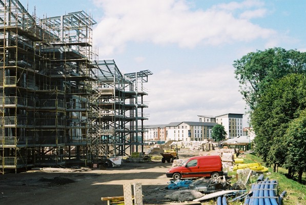
Terrace, Oatlands, Glasgow Six-storey housing blocks under construction beside the River Clyde. These form part of the Oatlands Regeneration project, led by Glasgow City Council (lead developer - Gladedale). Nearly 1,300 houses are being built and Richmond Park is being upgraded as part
600:"}},"text\/plain":{"en":{"":"URL"}}},"{\"value\":\"https:\\\/\\\/www.geograph.org.uk\\\/profile\\\/17132\",\"type\":\"string\"}":{"text\/html":{"en":{"P2699":"
260:
210:
921:"}},"text\/plain":{"en":{"":"geograph.org.uk image ID"}}},"{\"value\":\"543950\",\"type\":\"string\"}":{"text\/html":{"en":{"P7384":"
1139:== {{int:filedesc}} == {{Information |description={{en|1=Haughview Terrace, Oatlands, Glasgow Six-storey housing blocks under construction beside the River Clyde. These form part of the Oatlands Regeneration project, led by Glasgow City Council (lead dev
402:– You must give appropriate credit, provide a link to the license, and indicate if changes were made. You may do so in any reasonable manner, but not in any way that suggests the licensor endorses you or your use.
46:
78:
224:
274:
1228:
451:
922:
898:
748:
704:
906:
609:
1017:
1013:
918:
894:
830:
826:
700:
613:
605:
597:
601:
914:
910:
902:
788:
744:
593:
468:
1132:
751:"}},"text\/plain":{"en":{"P275":"Creative Commons Attribution-ShareAlike 2.0 Generic"}}}}": -->
1121:
1116:
37:
948:
774:
730:
284:
234:
968:
319:
1164:
This file contains additional information, probably added from the digital camera or scanner used to create or digitize it.
409:
672:
1058:
1031:
991:
932:
871:
844:
714:
680:
665:
650:
544:
976:
961:
798:
758:
623:
582:
491:
483:
1251:
365:
1167:
If the file has been modified from its original state, some details may not fully reflect the modified file.
464:
408:– If you remix, transform, or build upon the material, you must distribute your contributions under the
326:
on the
Geograph website for the photographer's contact details. The copyright on this image is owned by
1176:
707:"}},"text\/plain":{"en":{"P6216":"copyrighted"}}}}": -->
1149:
The following pages on the
English Knowledge use this file (pages on other projects are not listed):
1024:"}},"text\/plain":{"en":{"P7787":"270 degree"}}}}": -->
837:"}},"text\/plain":{"en":{"P7787":"270 degree"}}}}": -->
472:
86:
925:"}},"text\/plain":{"en":{"P7384":"543950"}}}}": -->
179:
457:
Remove redundant categories and try to put this image in the most specific category/categories
657:
998:
983:
362:
163:
535:
8:
306:
539:
531:
527:
523:
519:
515:
511:
507:
503:
499:
290:
240:
1153:
331:
73:
572:
152:
142:
1041:
942:
854:
808:
768:
724:
633:
1270:
311:
323:
1089:
Click on a date/time to view the file as it appeared at that time.
111:
Haughview
Terrace, Oatlands, Glasgow - geograph.org.uk - 543950.jpg
47:
Haughview_Terrace,_Oatlands,_Glasgow_-_geograph.org.uk_-_543950.jpg
1186:
276:
226:
261:
55° 50′ 32″ N, 4° 14′ 13″ W
211:
55° 50′ 31″ N, 4° 14′ 09″ W
131:
61:
566:
Add a one-line explanation of what this file represents
471:
combined with a database. You can also have a look at
463:
The location categories are based on information from
1147:
1087:
85:
Commons is a freely licensed media file repository.
775:
Creative
Commons Attribution-ShareAlike 2.0 Generic
749:
Creative
Commons Attribution-ShareAlike 2.0 Generic
51:(597 × 400 pixels, file size: 106 KB, MIME type:
448:The categories of this image should be checked.
419:https://creativecommons.org/licenses/by-sa/2.0
66:
602:https:\/\/www.geograph.org.uk\/profile\/17132
425:Creative Commons Attribution-Share Alike 2.0
343:
127:
108:
915:https:\/\/www.geograph.org.uk\/photo\/543950
148:
137:
14:
1021:
834:
385:– to copy, distribute and transmit the work
658:https://www.geograph.org.uk/profile/17132
984:https://www.geograph.org.uk/photo/543950
490:This image was uploaded as part of the
283:View this and other nearby images on:
233:View this and other nearby images on:
1229:FDi V4.5 / FRONTIER350/370-6.0-0E-742
478:The topic category from Geograph was
186:
97:
330:and is licensed for reuse under the
251:
201:
194:Haughview Terrace, Oatlands, Glasgow
175:Haughview Terrace, Oatlands, Glasgow
1080:
366:Attribution-Share Alike 2.0 Generic
354:
349:
334:Attribution-ShareAlike 2.0 license.
13:
1162:
571:
565:
340:
317:
115:
98:
44:
1287:
1169:
570:
1193:Date and time of data generation
1148:
845:coordinates of the point of view
827:coordinates of the point of view
556:
441:
396:Under the following conditions:
361:This file is licensed under the
353:
348:
342:
310:
289:
275:
267:
239:
225:
217:
65:
21:
553:
116:
41:No higher resolution available.
1084:
949:file available on the internet
899:file available on the internet
552:
318:This image was taken from the
26:
1:
1032:coordinates of depicted place
1014:coordinates of depicted place
31:
1144:
969:Geograph Britain and Ireland
907:Geograph Britain and Ireland
666:object of statement has role
606:object of statement has role
578:Items portrayed in this file
302:
266:
216:
7:
1262:Date and time of digitizing
1159:
1047:55°50'31.70"N, 4°14'13.20"W
10:
1292:
860:55°50'31.45"N, 4°14'8.52"W
410:same or compatible license
105:
100:
1235:File change date and time
1177:FUJI PHOTO FILM CO., LTD.
1081:
16:
992:geograph.org.uk image ID
919:geograph.org.uk image ID
555:
473:this tool from mysociety
439:
438:
376:
72:This is a file from the
36:
1138:
469:this OpenStreetMap tool
164:required by the license
130:
76:. Information from its
1117:23:39, 5 February 2011
324:this photograph's page
295:55.842140; -4.237000
245:55.842070; -4.235700
192:Ron Smith /
173:Ron Smith /
79:description page there
1209:Horizontal resolution
492:Geograph batch upload
482:(find similar images
1265:14:13, 9 August 2007
1238:14:13, 9 August 2007
460:Remove this template
1243:Y and C positioning
1217:Vertical resolution
1173:Camera manufacturer
536:português do Brasil
391:– to adapt the work
681:author name string
614:author name string
465:this geonames tool
1279:
1278:
1154:Oatlands, Glasgow
1142:
1023:
836:
759:copyright license
745:copyright license
564:
547:
494:
484:scene at Geograph
339:
338:
322:collection. See
300:
299:
250:
249:
199:
198:
167:
94:
93:
74:Wikimedia Commons
1283:
1170:
1129:
1091:
1069:
1068:
1063:
1001:
996:
986:
981:
977:described at URL
971:
966:
911:described at URL
882:
881:
876:
715:copyright status
701:copyright status
688:
685:
675:
670:
660:
655:
562:
548:
543:
489:
446:
445:
444:
432:
429:
426:
423:
420:
412:as the original.
374:
363:Creative Commons
357:
356:
352:
351:
346:
345:
332:Creative Commons
320:Geograph project
314:
307:
296:
293:
279:
278:
272:
271:
270:
264:
263:
252:
246:
243:
229:
228:
222:
221:
220:
214:
213:
202:
161:
133:
120:
112:
106:
90:
69:
68:
62:
56:
54:
1291:
1290:
1286:
1285:
1284:
1282:
1281:
1280:
1158:
1150:
1143:
1135:
1127:
1083:
1082:
1079:
1078:
1077:
1076:
1075:
1074:
1073:
1072:
1071:
1070:
1066:
1064:
1061:
1052:
1051:
1050:
1048:
1038:
1037:
1036:
1034:
1011:
1010:
1009:
1008:
1007:
1006:
1005:
1004:
1003:
1002:
997:
994:
988:
987:
982:
979:
973:
972:
967:
964:
955:
954:
953:
951:
939:
938:
937:
935:
892:
891:
890:
889:
888:
887:
886:
885:
884:
883:
879:
877:
874:
865:
864:
863:
861:
851:
850:
849:
847:
824:
823:
822:
821:
820:
819:
818:
817:
815:
805:
804:
803:
801:
786:
785:
784:
783:
782:
781:
780:
779:
777:
765:
764:
763:
761:
742:
741:
740:
739:
738:
737:
736:
735:
733:
721:
720:
719:
717:
698:
697:
696:
695:
694:
693:
692:
691:
690:
689:
686:
683:
677:
676:
671:
668:
662:
661:
656:
653:
644:
643:
642:
640:
630:
629:
628:
626:
591:
590:
589:
588:
587:
585:
569:
568:
567:
550:
498:
495:
452:Check them now!
442:
440:
434:
433:
430:
427:
424:
421:
418:
417:
375:
372:
369:
358:
335:
305:
294:
268:
259:
258:
255:Object location
244:
218:
209:
208:
205:Camera location
200:
189:
182:
170:
143:geograph.org.uk
123:
110:
103:
96:
95:
84:
83:
82:is shown below.
58:
52:
50:
43:
42:
12:
11:
5:
1289:
1277:
1276:
1273:
1267:
1266:
1263:
1259:
1258:
1255:
1248:
1247:
1244:
1240:
1239:
1236:
1232:
1231:
1226:
1222:
1221:
1218:
1214:
1213:
1210:
1206:
1205:
1202:
1198:
1197:
1194:
1190:
1189:
1184:
1180:
1179:
1174:
1161:
1157:
1156:
1146:
1141:
1140:
1137:
1133:
1130:
1124:
1119:
1114:
1110:
1109:
1106:
1103:
1100:
1097:
1094:
1086:
1057:
1056:
1055:
1054:
1053:
1049:
1046:
1044:
1043:
1042:
1040:
1039:
1035:
1030:
1028:
1027:
1026:
1025:
1019:
1015:
990:
989:
975:
974:
960:
959:
958:
957:
956:
952:
947:
945:
944:
943:
941:
940:
936:
933:source of file
931:
929:
928:
927:
926:
924:
920:
916:
912:
908:
904:
900:
896:
895:source of file
870:
869:
868:
867:
866:
862:
859:
857:
856:
855:
853:
852:
848:
843:
841:
840:
839:
838:
832:
828:
816:
813:
811:
810:
809:
807:
806:
802:
797:
795:
794:
793:
792:
790:
778:
773:
771:
770:
769:
767:
766:
762:
757:
755:
754:
753:
752:
750:
746:
734:
729:
727:
726:
725:
723:
722:
718:
713:
711:
710:
709:
708:
706:
702:
679:
678:
664:
663:
649:
648:
647:
646:
645:
641:
638:
636:
635:
634:
632:
631:
627:
622:
620:
619:
618:
617:
615:
611:
607:
603:
599:
595:
586:
581:
579:
576:
575:
574:
573:
561:
560:
557:
554:
488:
487:
476:
461:
458:
416:
415:
414:
413:
403:
394:
393:
392:
386:
379:You are free:
370:
360:
359:
341:
337:
336:
315:
304:
301:
298:
297:
287:
281:
256:
248:
247:
237:
231:
206:
197:
196:
190:
187:
184:
183:
178:
171:
168:
156:
155:
150:
146:
145:
139:
135:
134:
129:
125:
124:
122:of the scheme.
113:
104:
102:
99:
92:
91:
70:
60:
59:
40:
35:
34:
29:
24:
19:
9:
6:
4:
3:
2:
1288:
1274:
1272:
1269:
1268:
1264:
1261:
1260:
1256:
1253:
1250:
1249:
1245:
1242:
1241:
1237:
1234:
1233:
1230:
1227:
1225:Software used
1224:
1223:
1219:
1216:
1215:
1211:
1208:
1207:
1203:
1200:
1199:
1195:
1192:
1191:
1188:
1185:
1182:
1181:
1178:
1175:
1172:
1171:
1168:
1165:
1155:
1152:
1151:
1136:
1131:
1125:
1123:
1120:
1118:
1115:
1112:
1111:
1107:
1104:
1101:
1098:
1095:
1093:
1092:
1090:
1060:
1045:
1033:
1029:
1000:
993:
985:
978:
970:
963:
950:
946:
934:
930:
873:
858:
846:
842:
814:9 August 2007
812:
800:
796:
776:
772:
760:
756:
732:
728:
716:
712:
682:
674:
667:
659:
652:
637:
625:
621:
584:
580:
577:
558:
551:
549:
546:
541:
537:
533:
529:
525:
521:
517:
513:
509:
505:
501:
496:
493:
485:
481:
477:
474:
470:
466:
462:
459:
456:
455:
454:
453:
449:
437:
436:
422:CC BY-SA 2.0
411:
407:
404:
401:
398:
397:
395:
390:
387:
384:
381:
380:
378:
377:
371:Attribution:
367:
364:
347:
333:
329:
325:
321:
316:
313:
309:
308:
292:
288:
286:
285:OpenStreetMap
282:
280:
262:
257:
254:
253:
242:
238:
236:
235:OpenStreetMap
232:
230:
212:
207:
204:
203:
195:
191:
185:
181:
177: /
176:
172:
165:
160:
158:
157:
154:
151:
147:
144:
140:
136:
132:9 August 2007
126:
119:
114:
107:
88:
81:
80:
75:
71:
64:
63:
57:
48:
39:
33:
30:
28:
25:
23:
20:
18:
15:
1196:Unknown date
1183:Camera model
1166:
1163:
1088:
1085:File history
673:photographer
610:photographer
497:
480:Street scene
479:
450:
447:
435:
405:
399:
388:
382:
327:
265:
215:
193:
180:CC BY-SA 2.0
174:
117:
87:You can help
77:
45:
22:File history
1271:Color space
1201:Orientation
1134:GeographBot
731:copyrighted
705:copyrighted
406:share alike
400:attribution
159:Attribution
109:Description
1145:File usage
1126:597 × 400
1102:Dimensions
639:some value
524:македонски
53:image/jpeg
27:File usage
1099:Thumbnail
1096:Date/Time
799:inception
789:inception
687:Ron Smith
532:português
373:Ron Smith
328:Ron Smith
303:Licensing
188:InfoField
169:InfoField
153:Ron Smith
118:English:
1246:Centered
1160:Metadata
1128:(106 KB)
962:operator
903:operator
559:Captions
542: |
538: |
534: |
530: |
526: |
522: |
518: |
514: |
510: |
508:français
506: |
502: |
389:to remix
383:to share
368:license.
32:Metadata
1254:version
1187:SP-2000
1113:current
1108:Comment
1059:heading
1018:heading
872:heading
831:heading
624:creator
594:creator
583:depicts
563:English
500:English
101:Summary
49:
1220:72 dpi
1212:72 dpi
1204:Normal
1067:degree
1022:degree
999:543950
923:543950
880:degree
835:degree
540:Türkçe
528:മലയാളം
520:magyar
512:galego
273:
223:
149:Author
138:Source
516:עברית
504:suomi
141:From
1275:sRGB
1252:Exif
1105:User
1065:270
878:270
467:and
431:true
428:true
128:Date
17:File
1257:2.1
651:URL
598:URL
545:+/−
1062::
995::
980::
965::
875::
684::
669::
654::
486:)
475:.
166:)
162:(
89:.
55:)
Text is available under the Creative Commons Attribution-ShareAlike License. Additional terms may apply.
_heading:270.00&language=en)
_heading:270.00&language=en)
