851:"}},"text\/plain":{"en":{"":"coordinates of the point of view"}}},"{\"value\":{\"latitude\":51.80971,\"longitude\":-2.301,\"altitude\":null,\"precision\":1.0e-5,\"globe\":\"http:\\\/\\\/www.wikidata.org\\\/entity\\\/Q2\"},\"type\":\"globecoordinate\"}":{"text\/html":{"en":{"P1259":"51\u00b048'34.96"N, 2\u00b018'3.60"W"}},"text\/plain":{"en":{"P1259":"51\u00b048'34.96\"N, 2\u00b018'3.60\"W"}}},"{\"value\":{\"entity-type\":\"property\",\"numeric-id\":7787,\"id\":\"P7787\"},\"type\":\"wikibase-entityid\"}":{"text\/html":{"en":{"":"
919:"}},"text\/plain":{"en":{"":"coordinates of depicted place"}}},"{\"value\":{\"latitude\":51.81008,\"longitude\":-2.3004,\"altitude\":null,\"precision\":1.0e-5,\"globe\":\"http:\\\/\\\/www.wikidata.org\\\/entity\\\/Q2\"},\"type\":\"globecoordinate\"}":{"text\/html":{"en":{"P9149":"51\u00b048'36.29"N, 2\u00b018'1.44"W"}},"text\/plain":{"en":{"P9149":"51\u00b048'36.29\"N, 2\u00b018'1.44\"W"}}},"{\"value\":{\"entity-type\":\"property\",\"numeric-id\":7787,\"id\":\"P7787\"},\"type\":\"wikibase-entityid\"}":{"text\/html":{"en":{"":"
511:"}},"text\/plain":{"en":{"":"author name string"}}},"{\"value\":\"Philip Halling\",\"type\":\"string\"}":{"text\/html":{"en":{"P2093":"Philip Halling"}},"text\/plain":{"en":{"P2093":"Philip Halling"}}},"{\"value\":{\"entity-type\":\"property\",\"numeric-id\":2699,\"id\":\"P2699\"},\"type\":\"wikibase-entityid\"}":{"text\/html":{"en":{"":"
813:"}},"text\/plain":{"en":{"":"inception"}}},"{\"value\":{\"time\":\"+2008-04-26T00:00:00Z\",\"timezone\":0,\"before\":0,\"after\":0,\"precision\":11,\"calendarmodel\":\"http:\\\/\\\/www.wikidata.org\\\/entity\\\/Q1985727\"},\"type\":\"time\"}":{"text\/html":{"en":{"P571":"26 April 2008"}},"text\/plain":{"en":{"P571":"26 April 2008"}}}}": -->
690:
296:
246:
915:
238:
310:
260:
331:
369:
374:
43:
87:
706:"}},"text\/plain":{"en":{"P973":"https:\/\/www.geograph.org.uk\/photo\/783268"}}},"{\"value\":{\"entity-type\":\"property\",\"numeric-id\":7384,\"id\":\"P7384\"},\"type\":\"wikibase-entityid\"}":{"text\/html":{"en":{"":"
698:"}},"text\/plain":{"en":{"P7482":"file available on the internet"}}},"{\"value\":{\"entity-type\":\"property\",\"numeric-id\":973,\"id\":\"P973\"},\"type\":\"wikibase-entityid\"}":{"text\/html":{"en":{"":"
503:"}},"text\/plain":{"en":{"":"object of statement has role"}}},"{\"value\":{\"entity-type\":\"item\",\"numeric-id\":33231,\"id\":\"Q33231\"},\"type\":\"wikibase-entityid\"}":{"text\/html":{"en":{"P3831":"
987:"}},"text\/plain":{"en":{"":"media type"}}},"{\"value\":\"image\\\/jpeg\",\"type\":\"string\"}":{"text\/html":{"en":{"P1163":"image\/jpeg"}},"text\/plain":{"en":{"P1163":"image\/jpeg"}}}}": -->
650:"}},"text\/plain":{"en":{"":"copyright license"}}},"{\"value\":{\"entity-type\":\"item\",\"numeric-id\":19068220,\"id\":\"Q19068220\"},\"type\":\"wikibase-entityid\"}":{"text\/html":{"en":{"P275":"
606:"}},"text\/plain":{"en":{"":"copyright status"}}},"{\"value\":{\"entity-type\":\"item\",\"numeric-id\":50423863,\"id\":\"Q50423863\"},\"type\":\"wikibase-entityid\"}":{"text\/html":{"en":{"P6216":"
694:"}},"text\/plain":{"en":{"":"source of file"}}},"{\"value\":{\"entity-type\":\"item\",\"numeric-id\":74228490,\"id\":\"Q74228490\"},\"type\":\"wikibase-entityid\"}":{"text\/html":{"en":{"P7482":"
507:"}},"text\/plain":{"en":{"P3831":"photographer"}}},"{\"value\":{\"entity-type\":\"property\",\"numeric-id\":2093,\"id\":\"P2093\"},\"type\":\"wikibase-entityid\"}":{"text\/html":{"en":{"":"
718:"}},"text\/plain":{"en":{"":"operator"}}},"{\"value\":{\"entity-type\":\"item\",\"numeric-id\":1503119,\"id\":\"Q1503119\"},\"type\":\"wikibase-entityid\"}":{"text\/html":{"en":{"P137":"
923:"}},"text\/plain":{"en":{"":"heading"}}},"{\"value\":{\"amount\":\"+45\",\"unit\":\"http:\\\/\\\/www.wikidata.org\\\/entity\\\/Q28390\"},\"type\":\"quantity\"}":{"text\/html":{"en":{"P7787":"45
855:"}},"text\/plain":{"en":{"":"heading"}}},"{\"value\":{\"amount\":\"+45\",\"unit\":\"http:\\\/\\\/www.wikidata.org\\\/entity\\\/Q28390\"},\"type\":\"quantity\"}":{"text\/html":{"en":{"P7787":"45
714:"}},"text\/plain":{"en":{"P7384":"783268"}}},"{\"value\":{\"entity-type\":\"property\",\"numeric-id\":137,\"id\":\"P137\"},\"type\":\"wikibase-entityid\"}":{"text\/html":{"en":{"":"
499:"}},"text\/plain":{"en":{"":"creator"}}},"{\"value\":{\"entity-type\":\"property\",\"numeric-id\":3831,\"id\":\"P3831\"},\"type\":\"wikibase-entityid\"}":{"text\/html":{"en":{"":"
983:
809:
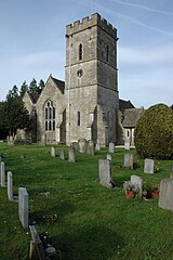
1080:== {{int:filedesc}} == {{Information |description={{en|1=Hardwicke Church Hardwicke church is dedicated to St Nicholas, the church is situated between the Gloucester and Sharpness Canal and the A38.}} |date=2008-04-26 |source=From [http://www.geograph.org
229:
421:– You must give appropriate credit, provide a link to the license, and indicate if changes were made. You may do so in any reasonable manner, but not in any way that suggests the licensor endorses you or your use.
293:
243:
711:
695:
651:
607:
719:
53:
47:
98:
504:
66:
984:
920:
916:
852:
848:
707:
691:
603:
512:
508:
500:
810:
715:
703:
699:
647:
516:
496:
1073:
1094:
141:
Hardwicke Church
Hardwicke church is dedicated to St Nicholas, the church is situated between the Gloucester and Sharpness Canal and the A38.
654:"}},"text\/plain":{"en":{"P275":"Creative Commons Attribution-ShareAlike 2.0 Generic"}}}}": -->
519:"}},"text\/plain":{"en":{"P2699":"https:\/\/www.geograph.org.uk\/profile\/1837"}}}}": -->
745:
677:
633:
303:
253:
795:
338:
1210:
This file contains additional information, probably added from the digital camera or scanner used to create or digitize it.
428:
560:
994:
961:
934:
893:
866:
773:
729:
617:
581:
568:
553:
820:
788:
758:
661:
526:
485:
722:"}},"text\/plain":{"en":{"P137":"Geograph Britain and Ireland"}}}}": -->
1062:
1057:
57:
42:
384:
1213:
If the file has been modified from its original state, some details may not fully reflect the modified file.
427:– If you remix, transform, or build upon the material, you must distribute your contributions under the
345:
on the
Geograph website for the photographer's contact details. The copyright on this image is owned by
610:"}},"text\/plain":{"en":{"P6216":"copyrighted"}}}}": -->
1090:
The following pages on the
English Knowledge use this file (pages on other projects are not listed):
927:"}},"text\/plain":{"en":{"P7787":"45 degree"}}}}": -->
859:"}},"text\/plain":{"en":{"P7787":"45 degree"}}}}": -->
106:
198:
780:
765:
588:
381:
182:
8:
325:
309:
259:
1099:
350:
93:
475:
171:
161:
1004:
944:
876:
830:
739:
671:
627:
536:
330:
342:
1030:
Click on a date/time to view the file as it appeared at that time.
1177:
295:
245:
1167:
1157:
1137:
1187:
1127:
280:
51° 48′ 36″ N, 2° 18′ 01″ W
230:
51° 48′ 35″ N, 2° 18′ 04″ W
150:
81:
1147:
1117:
469:
Add a one-line explanation of what this file represents
1197:
1088:
1108:
1028:
105:
Commons is a freely licensed media file repository.
678:
Creative
Commons Attribution-ShareAlike 2.0 Generic
652:
Creative
Commons Attribution-ShareAlike 2.0 Generic
71:(426 × 640 pixels, file size: 67 KB, MIME type:
131:Hardwicke Church - geograph.org.uk - 783268.jpg
438:https://creativecommons.org/licenses/by-sa/2.0
86:
1095:Grade I listed buildings in Stroud (district)
444:Creative Commons Attribution-Share Alike 2.0
362:
146:
128:
704:https:\/\/www.geograph.org.uk\/photo\/783268
517:https:\/\/www.geograph.org.uk\/profile\/1837
167:
156:
14:
924:
856:
404:– to copy, distribute and transmit the work
1110:The following other wikis use this file:
766:https://www.geograph.org.uk/photo/783268
589:https://www.geograph.org.uk/profile/1837
302:View this and other nearby images on:
252:View this and other nearby images on:
205:
117:
349:and is licensed for reuse under the
270:
220:
1021:
385:Attribution-Share Alike 2.0 Generic
373:
368:
353:Attribution-ShareAlike 2.0 license.
13:
1208:
474:
468:
359:
336:
135:
118:
64:
1234:
1215:
473:
1089:
867:coordinates of the point of view
849:coordinates of the point of view
459:
415:Under the following conditions:
380:This file is licensed under the
372:
367:
361:
329:
308:
294:
286:
258:
244:
236:
85:
31:
21:
456:
136:
1174:Usage on simple.wikipedia.org
1105:
1025:
746:file available on the internet
696:file available on the internet
455:
337:This image was taken from the
26:
1:
935:coordinates of depicted place
917:coordinates of depicted place
36:
1085:
796:Geograph Britain and Ireland
720:Geograph Britain and Ireland
554:object of statement has role
501:object of statement has role
481:Items portrayed in this file
321:
7:
1205:
1144:Usage on lld.wikipedia.org
1114:Usage on ceb.wikipedia.org
285:
235:
211:Philip Halling /
192:Philip Halling /
10:
1239:
1194:Usage on www.wikidata.org
1184:Usage on tr.wikipedia.org
1164:Usage on pt.wikipedia.org
1154:Usage on pl.wikipedia.org
1134:Usage on fr.wikipedia.org
1124:Usage on cy.wikipedia.org
950:51°48'36.29"N, 2°18'1.44"W
882:51°48'34.96"N, 2°18'3.60"W
429:same or compatible license
125:
120:
1022:
16:
774:geograph.org.uk image ID
708:geograph.org.uk image ID
458:
395:
92:This is a file from the
41:
1079:
1058:01:28, 20 February 2011
183:required by the license
149:
96:. Information from its
343:this photograph's page
314:51.810080; -2.300400
264:51.809710; -2.301000
99:description page there
46:Size of this preview:
410:– to adapt the work
52:Other resolutions:
1168:Hardwicke (Stroud)
1158:Hardwicke (Stroud)
1138:Hardwicke (Stroud)
569:author name string
509:author name string
1226:
1225:
1188:Hardwicke, Stroud
1178:Hardwicke, Stroud
1128:Hardwicke, Stroud
1106:Global file usage
1100:Hardwicke, Stroud
1083:
926:
858:
662:copyright license
648:copyright license
467:
358:
357:
341:collection. See
319:
318:
269:
268:
218:
217:
186:
114:
113:
94:Wikimedia Commons
32:Global file usage
1230:
1216:
1070:
1032:
972:
971:
966:
904:
903:
898:
798:
793:
783:
778:
768:
763:
759:described at URL
700:described at URL
618:copyright status
604:copyright status
591:
586:
576:
573:
563:
558:
465:
451:
448:
445:
442:
439:
431:as the original.
393:
382:Creative Commons
376:
375:
371:
370:
365:
364:
351:Creative Commons
339:Geograph project
333:
326:
315:
312:
298:
297:
291:
290:
289:
283:
282:
271:
265:
262:
248:
247:
241:
240:
239:
233:
232:
221:
213:Hardwicke Church
194:Hardwicke Church
180:
152:
140:
132:
126:
110:
89:
88:
82:
76:
74:
61:
58:426 × 640 pixels
54:160 × 240 pixels
48:399 × 599 pixels
1238:
1237:
1233:
1232:
1231:
1229:
1228:
1227:
1204:
1104:
1091:
1084:
1076:
1068:
1024:
1023:
1020:
1019:
1018:
1017:
1016:
1015:
1014:
1013:
1011:
1001:
1000:
999:
997:
982:
981:
980:
979:
978:
977:
976:
975:
974:
973:
969:
967:
964:
955:
954:
953:
951:
941:
940:
939:
937:
914:
913:
912:
911:
910:
909:
908:
907:
906:
905:
901:
899:
896:
887:
886:
885:
883:
873:
872:
871:
869:
846:
845:
844:
843:
842:
841:
840:
839:
837:
827:
826:
825:
823:
808:
807:
806:
805:
804:
803:
802:
801:
800:
799:
794:
791:
785:
784:
779:
776:
770:
769:
764:
761:
752:
751:
750:
748:
736:
735:
734:
732:
689:
688:
687:
686:
685:
684:
683:
682:
680:
668:
667:
666:
664:
645:
644:
643:
642:
641:
640:
639:
638:
636:
624:
623:
622:
620:
601:
600:
599:
598:
597:
596:
595:
594:
593:
592:
587:
584:
578:
577:
574:
571:
565:
564:
559:
556:
547:
546:
545:
543:
533:
532:
531:
529:
494:
493:
492:
491:
490:
488:
472:
471:
470:
453:
452:
449:
446:
443:
440:
437:
436:
394:
391:
388:
377:
354:
324:
313:
287:
278:
277:
274:Object location
263:
237:
228:
227:
224:Camera location
219:
208:
201:
189:
162:geograph.org.uk
142:
130:
123:
116:
115:
104:
103:
102:is shown below.
78:
72:
70:
63:
62:
51:
12:
11:
5:
1236:
1224:
1223:
1220:
1207:
1203:
1202:
1201:
1200:
1192:
1191:
1190:
1182:
1181:
1180:
1172:
1171:
1170:
1162:
1161:
1160:
1152:
1151:
1150:
1142:
1141:
1140:
1132:
1131:
1130:
1122:
1121:
1120:
1107:
1103:
1102:
1097:
1087:
1082:
1081:
1078:
1074:
1071:
1065:
1060:
1055:
1051:
1050:
1047:
1044:
1041:
1038:
1035:
1027:
1012:
1009:
1007:
1006:
1005:
1003:
1002:
998:
993:
991:
990:
989:
988:
986:
960:
959:
958:
957:
956:
952:
949:
947:
946:
945:
943:
942:
938:
933:
931:
930:
929:
928:
922:
918:
892:
891:
890:
889:
888:
884:
881:
879:
878:
877:
875:
874:
870:
865:
863:
862:
861:
860:
854:
850:
838:
835:
833:
832:
831:
829:
828:
824:
819:
817:
816:
815:
814:
812:
787:
786:
772:
771:
757:
756:
755:
754:
753:
749:
744:
742:
741:
740:
738:
737:
733:
730:source of file
728:
726:
725:
724:
723:
721:
717:
713:
709:
705:
701:
697:
693:
692:source of file
681:
676:
674:
673:
672:
670:
669:
665:
660:
658:
657:
656:
655:
653:
649:
637:
632:
630:
629:
628:
626:
625:
621:
616:
614:
613:
612:
611:
609:
605:
580:
579:
575:Philip Halling
567:
566:
552:
551:
550:
549:
548:
544:
541:
539:
538:
537:
535:
534:
530:
525:
523:
522:
521:
520:
518:
514:
510:
506:
502:
498:
489:
484:
482:
479:
478:
477:
476:
464:
463:
460:
457:
435:
434:
433:
432:
422:
413:
412:
411:
405:
398:You are free:
392:Philip Halling
389:
379:
378:
360:
356:
355:
347:Philip Halling
334:
323:
320:
317:
316:
306:
300:
275:
267:
266:
256:
250:
225:
216:
215:
209:
206:
203:
202:
197:
190:
187:
175:
174:
172:Philip Halling
169:
165:
164:
158:
154:
153:
148:
144:
143:
133:
124:
122:
119:
112:
111:
90:
80:
79:
45:
40:
39:
34:
29:
24:
19:
9:
6:
4:
3:
2:
1235:
1221:
1218:
1217:
1214:
1211:
1199:
1196:
1195:
1193:
1189:
1186:
1185:
1183:
1179:
1176:
1175:
1173:
1169:
1166:
1165:
1163:
1159:
1156:
1155:
1153:
1149:
1146:
1145:
1143:
1139:
1136:
1135:
1133:
1129:
1126:
1125:
1123:
1119:
1116:
1115:
1113:
1112:
1111:
1101:
1098:
1096:
1093:
1092:
1077:
1072:
1066:
1064:
1061:
1059:
1056:
1053:
1052:
1048:
1045:
1042:
1039:
1036:
1034:
1033:
1031:
1008:
996:
992:
963:
948:
936:
932:
895:
880:
868:
864:
836:26 April 2008
834:
822:
818:
797:
790:
782:
775:
767:
760:
747:
743:
731:
727:
679:
675:
663:
659:
635:
631:
619:
615:
590:
583:
570:
562:
555:
540:
528:
524:
487:
483:
480:
461:
454:
441:CC BY-SA 2.0
430:
426:
423:
420:
417:
416:
414:
409:
406:
403:
400:
399:
397:
396:
390:Attribution:
386:
383:
366:
352:
348:
344:
340:
335:
332:
328:
327:
311:
307:
305:
304:OpenStreetMap
301:
299:
281:
276:
273:
272:
261:
257:
255:
254:OpenStreetMap
251:
249:
231:
226:
223:
222:
214:
210:
204:
200:
196: /
195:
191:
184:
179:
177:
176:
173:
170:
166:
163:
159:
155:
151:26 April 2008
145:
139:
134:
127:
108:
101:
100:
95:
91:
84:
83:
77:
68:
67:Original file
59:
55:
49:
44:
38:
35:
33:
30:
28:
25:
23:
20:
18:
15:
1212:
1209:
1109:
1029:
1026:File history
561:photographer
505:photographer
424:
418:
407:
401:
346:
284:
234:
212:
199:CC BY-SA 2.0
193:
137:
107:You can help
97:
65:
22:File history
1075:GeographBot
634:copyrighted
608:copyrighted
425:share alike
419:attribution
178:Attribution
129:Description
1219:_error
1086:File usage
1067:426 × 640
1043:Dimensions
1010:image/jpeg
995:media type
985:media type
542:some value
73:image/jpeg
27:File usage
1148:Hardwicke
1118:Hardwicke
1040:Thumbnail
1037:Date/Time
821:inception
811:inception
322:Licensing
207:InfoField
188:InfoField
138:English:
1206:Metadata
1198:Q5656480
789:operator
716:operator
462:Captions
408:to remix
402:to share
387:license.
37:Metadata
1069:(67 KB)
1054:current
1049:Comment
962:heading
921:heading
894:heading
853:heading
527:creator
497:creator
486:depicts
466:English
121:Summary
69:
970:degree
925:degree
902:degree
857:degree
781:783268
712:783268
292:
242:
168:Author
157:Source
160:From
1046:User
450:true
447:true
147:Date
17:File
968:45
900:45
582:URL
513:URL
965::
897::
792::
777::
762::
585::
572::
557::
56:|
50:.
1222:0
185:)
181:(
109:.
75:)
60:.
Text is available under the Creative Commons Attribution-ShareAlike License. Additional terms may apply.

_heading:45.00&language=en)
_heading:45.00&language=en)
