851:"}},"text\/plain":{"en":{"":"coordinates of the point of view"}}},"{\"value\":{\"latitude\":53.00937,\"longitude\":-1.766121,\"altitude\":null,\"precision\":1.0e-6,\"globe\":\"http:\\\/\\\/www.wikidata.org\\\/entity\\\/Q2\"},\"type\":\"globecoordinate\"}":{"text\/html":{"en":{"P1259":"53\u00b00'33.732"N, 1\u00b045'58.036"W"}},"text\/plain":{"en":{"P1259":"53\u00b00'33.732\"N, 1\u00b045'58.036\"W"}}},"{\"value\":{\"entity-type\":\"property\",\"numeric-id\":7787,\"id\":\"P7787\"},\"type\":\"wikibase-entityid\"}":{"text\/html":{"en":{"":"
511:"}},"text\/plain":{"en":{"":"author name string"}}},"{\"value\":\"John M\",\"type\":\"string\"}":{"text\/html":{"en":{"P2093":"John M"}},"text\/plain":{"en":{"P2093":"John M"}}},"{\"value\":{\"entity-type\":\"property\",\"numeric-id\":2699,\"id\":\"P2699\"},\"type\":\"wikibase-entityid\"}":{"text\/html":{"en":{"":"
813:"}},"text\/plain":{"en":{"":"inception"}}},"{\"value\":{\"time\":\"+2013-06-25T00:00:00Z\",\"timezone\":0,\"before\":0,\"after\":0,\"precision\":11,\"calendarmodel\":\"http:\\\/\\\/www.wikidata.org\\\/entity\\\/Q1985727\"},\"type\":\"time\"}":{"text\/html":{"en":{"P571":"25 June 2013"}},"text\/plain":{"en":{"P571":"25 June 2013"}}}}": -->
690:
269:
261:
847:
304:
342:
347:
72:
698:"}},"text\/plain":{"en":{"P7482":"file available on the internet"}}},"{\"value\":{\"entity-type\":\"property\",\"numeric-id\":137,\"id\":\"P137\"},\"type\":\"wikibase-entityid\"}":{"text\/html":{"en":{"":"
706:"}},"text\/plain":{"en":{"P137":"Geograph Britain and Ireland"}}},"{\"value\":{\"entity-type\":\"property\",\"numeric-id\":7384,\"id\":\"P7384\"},\"type\":\"wikibase-entityid\"}":{"text\/html":{"en":{"":"
503:"}},"text\/plain":{"en":{"":"object of statement has role"}}},"{\"value\":{\"entity-type\":\"item\",\"numeric-id\":33231,\"id\":\"Q33231\"},\"type\":\"wikibase-entityid\"}":{"text\/html":{"en":{"P3831":"
650:"}},"text\/plain":{"en":{"":"copyright license"}}},"{\"value\":{\"entity-type\":\"item\",\"numeric-id\":19068220,\"id\":\"Q19068220\"},\"type\":\"wikibase-entityid\"}":{"text\/html":{"en":{"P275":"
606:"}},"text\/plain":{"en":{"":"copyright status"}}},"{\"value\":{\"entity-type\":\"item\",\"numeric-id\":50423863,\"id\":\"Q50423863\"},\"type\":\"wikibase-entityid\"}":{"text\/html":{"en":{"P6216":"
694:"}},"text\/plain":{"en":{"":"source of file"}}},"{\"value\":{\"entity-type\":\"item\",\"numeric-id\":74228490,\"id\":\"Q74228490\"},\"type\":\"wikibase-entityid\"}":{"text\/html":{"en":{"P7482":"
919:"}},"text\/plain":{"en":{"":"captured with"}}},"{\"value\":{\"entity-type\":\"item\",\"numeric-id\":729993,\"id\":\"Q729993\"},\"type\":\"wikibase-entityid\"}":{"text\/html":{"en":{"P4082":"
507:"}},"text\/plain":{"en":{"P3831":"photographer"}}},"{\"value\":{\"entity-type\":\"property\",\"numeric-id\":2093,\"id\":\"P2093\"},\"type\":\"wikibase-entityid\"}":{"text\/html":{"en":{"":"
452:"}},"text\/plain":{"en":{"":"depicts"}}},"{\"value\":{\"entity-type\":\"item\",\"numeric-id\":17545763,\"id\":\"Q17545763\"},\"type\":\"wikibase-entityid\"}":{"text\/html":{"en":{"P180":"
855:"}},"text\/plain":{"en":{"":"heading"}}},"{\"value\":{\"amount\":\"+112\",\"unit\":\"http:\\\/\\\/www.wikidata.org\\\/entity\\\/Q28390\"},\"type\":\"quantity\"}":{"text\/html":{"en":{"P7787":"112
702:"}},"text\/plain":{"en":{"":"operator"}}},"{\"value\":{\"entity-type\":\"item\",\"numeric-id\":1503119,\"id\":\"Q1503119\"},\"type\":\"wikibase-entityid\"}":{"text\/html":{"en":{"P137":"
1001:
714:"}},"text\/plain":{"en":{"P7384":"3535819"}}},"{\"value\":{\"entity-type\":\"property\",\"numeric-id\":973,\"id\":\"P973\"},\"type\":\"wikibase-entityid\"}":{"text\/html":{"en":{"":"
499:"}},"text\/plain":{"en":{"":"creator"}}},"{\"value\":{\"entity-type\":\"property\",\"numeric-id\":3831,\"id\":\"P3831\"},\"type\":\"wikibase-entityid\"}":{"text\/html":{"en":{"":"
915:
710:"}},"text\/plain":{"en":{"":"geograph.org.uk image ID"}}},"{\"value\":\"3535819\",\"type\":\"string\"}":{"text\/html":{"en":{"P7384":"
252:
394:– You must give appropriate credit, provide a link to the license, and indicate if changes were made. You may do so in any reasonable manner, but not in any way that suggests the licensor endorses you or your use.
266:
83:
51:
711:
695:
651:
607:
453:
703:
920:
504:
916:
852:
848:
707:
691:
603:
512:
508:
500:
719:
810:
715:
699:
647:
516:
496:
449:
1018:== {{int:filedesc}} == {{Information |Description={{en|1=Hanging Mill Bridge}} |Source=From |Date=2013-06-25 |Author= |Permission=Creative Common...
1037:
654:"}},"text\/plain":{"en":{"P275":"Creative Commons Attribution-ShareAlike 2.0 Generic"}}}}": -->
1060:
1210:
189:
722:"}},"text\/plain":{"en":{"P973":"https:\/\/www.geograph.org.uk\/photo\/3535819"}}}}": -->
519:"}},"text\/plain":{"en":{"P2699":"https:\/\/www.geograph.org.uk\/profile\/7388"}}}}": -->
745:
677:
633:
482:
276:
765:
311:
1128:
This file contains additional information, probably added from the digital camera or scanner used to create or digitize it.
946:
401:
560:
1000:
995:
930:
893:
866:
773:
729:
617:
581:
568:
553:
42:
820:
788:
758:
661:
526:
466:
1241:
357:
1131:
If the file has been modified from its original state, some details may not fully reflect the modified file.
400:– If you remix, transform, or build upon the material, you must distribute your contributions under the
318:
on the
Geograph website for the photographer's contact details. The copyright on this image is owned by
456:"}},"text\/plain":{"en":{"P180":"Hanging Bridge"}}}}": -->
110:
923:"}},"text\/plain":{"en":{"P4082":"Nikon D3200"}}}}": -->
610:"}},"text\/plain":{"en":{"P6216":"copyrighted"}}}}": -->
115:
1028:
The following pages on the
English Knowledge use this file (pages on other projects are not listed):
859:"}},"text\/plain":{"en":{"P7787":"112 degree"}}}}": -->
1042:
91:
221:
1289:
1070:
795:
780:
1061:
Mayfield (lungsod sa
Hiniusang Gingharian, Inglatera, Staffordshire, lat 53,00, long -1,77)
588:
354:
205:
8:
1325:
1032:
298:
282:
1462:
1140:
1011:
323:
78:
1417:
1307:
1157:
168:
1472:
1427:
1197:
178:
940:
876:
830:
739:
671:
627:
536:
476:
1367:
1150:
303:
1177:
1100:
315:
1090:
1080:
1482:
1167:
968:
Click on a date/time to view the file as it appeared at that time.
268:
253:
53° 00′ 33.73″ N, 1° 45′ 58.04″ W
157:
66:
442:
Add a one-line explanation of what this file represents
1115:
138:
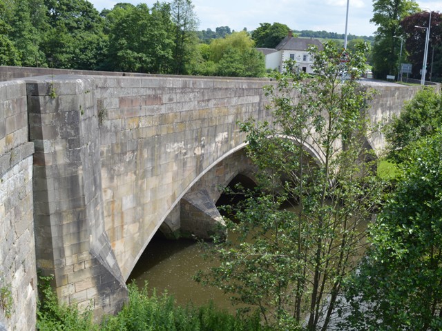
Hanging Bridge
Mayfield Geograph-3535819-by-John-M.jpg
52:
Hanging_Bridge_Mayfield_Geograph-3535819-by-John-M.jpg
1110:
1026:
1051:
966:
196:
Creative
Commons Attribution Share-alike license 2.0
90:
Commons is a freely licensed media file repository.
678:
Creative
Commons Attribution-ShareAlike 2.0 Generic
652:
Creative
Commons Attribution-ShareAlike 2.0 Generic
56:(640 × 480 pixels, file size: 168 KB, MIME type:
1071:Grade II* listed buildings in Derbyshire Dales
1038:Grade II* listed buildings in Derbyshire Dales
411:https://creativecommons.org/licenses/by-sa/2.0
71:
720:https:\/\/www.geograph.org.uk\/photo\/3535819
417:Creative Commons Attribution-Share Alike 2.0
335:
184:
153:
135:
517:https:\/\/www.geograph.org.uk\/profile\/7388
174:
163:
14:
856:
377:– to copy, distribute and transmit the work
1053:The following other wikis use this file:
796:https://www.geograph.org.uk/photo/3535819
589:https://www.geograph.org.uk/profile/7388
275:View this and other nearby images on:
228:
102:
322:and is licensed for reuse under the
243:
959:
358:Attribution-Share Alike 2.0 Generic
346:
341:
326:Attribution-ShareAlike 2.0 license.
13:
1126:
447:
441:
332:
309:
142:
108:
103:
49:
1515:
1133:
446:
1188:Date and time of data generation
1027:
867:coordinates of the point of view
849:coordinates of the point of view
432:
388:Under the following conditions:
353:This file is licensed under the
345:
340:
334:
302:
281:
267:
259:
70:
31:
21:
429:
143:
46:No higher resolution available.
1048:
963:
746:file available on the internet
696:file available on the internet
428:
310:This image was taken from the
26:
1:
1396:A directly photographed image
1330:Flash did not fire, auto mode
36:
1351:DateTimeDigitized subseconds
1023:
882:53°0'33.732"N, 1°45'58.036"W
766:Geograph Britain and Ireland
704:Geograph Britain and Ireland
554:object of statement has role
501:object of statement has role
462:Items portrayed in this file
294:
258:
7:
1343:DateTimeOriginal subseconds
1252:Date and time of digitizing
1123:
1097:Usage on lld.wikipedia.org
1067:Usage on dag.wikipedia.org
1057:Usage on ceb.wikipedia.org
10:
1520:
1438:Focal length in 35 mm film
1380:One-chip color area sensor
1359:Supported Flashpix version
1107:Usage on www.wikidata.org
1087:Usage on fr.wikipedia.org
1077:Usage on es.wikipedia.org
402:same or compatible license
132:
127:
104:
1260:Meaning of each component
1217:File change date and time
960:
16:
1101:Mayfield (Staffordshire)
1091:Mayfield (Staffordshire)
1081:Mayfield (Staffordshire)
774:geograph.org.uk image ID
708:geograph.org.uk image ID
431:
368:
77:This is a file from the
41:
1401:Custom image processing
1043:Mayfield, Staffordshire
1017:
206:required by the license
156:
81:. Information from its
1492:Subject distance range
1281:Image compression mode
316:this photograph's page
287:53.009370; -1.766121
84:description page there
1299:Maximum land aperture
996:15:11, 23 August 2013
1388:Digital still camera
1335:DateTime subseconds
1255:13:18, 25 June 2013
1225:Y and C positioning
1220:13:18, 25 June 2013
1191:13:18, 25 June 2013
1137:Camera manufacturer
1033:Clifton and Compton
383:– to adapt the work
236:Hanging Mill Bridge
234:John M /
217:Hanging Mill Bridge
215:John M /
148:Hanging Mill Bridge
109:This is a photo of
1446:Scene capture type
1422:Auto white balance
569:author name string
509:author name string
1507:
1506:
1302:3.8 APEX (f/3.73)
1162:1/200 sec (0.005)
1141:NIKON CORPORATION
1049:Global file usage
1021:
858:
662:copyright license
648:copyright license
440:
331:
330:
314:collection. See
292:
291:
241:
240:
209:
193:
190:Reusing this file
125:
124:
99:
98:
79:Wikimedia Commons
32:Global file usage
1511:
1233:Exposure Program
1134:
1008:
970:
904:
903:
898:
798:
793:
789:described at URL
783:
778:
768:
763:
716:described at URL
618:copyright status
604:copyright status
591:
586:
576:
573:
563:
558:
438:
424:
421:
418:
415:
412:
404:as the original.
366:
355:Creative Commons
349:
348:
344:
343:
338:
337:
324:Creative Commons
312:Geograph project
306:
299:
288:
285:
271:
270:
264:
263:
262:
256:
255:
244:
203:
187:
159:
147:
139:
133:
118:
105:
95:
74:
73:
67:
61:
59:
1519:
1518:
1514:
1513:
1512:
1510:
1509:
1508:
1500:GPS tag version
1122:
1047:
1029:
1022:
1014:
1006:
962:
961:
958:
957:
956:
955:
954:
953:
952:
951:
949:
937:
936:
935:
933:
914:
913:
912:
911:
910:
909:
908:
907:
906:
905:
901:
899:
896:
887:
886:
885:
883:
873:
872:
871:
869:
846:
845:
844:
843:
842:
841:
840:
839:
837:
827:
826:
825:
823:
808:
807:
806:
805:
804:
803:
802:
801:
800:
799:
794:
791:
785:
784:
779:
776:
770:
769:
764:
761:
752:
751:
750:
748:
736:
735:
734:
732:
689:
688:
687:
686:
685:
684:
683:
682:
680:
668:
667:
666:
664:
645:
644:
643:
642:
641:
640:
639:
638:
636:
624:
623:
622:
620:
601:
600:
599:
598:
597:
596:
595:
594:
593:
592:
587:
584:
578:
577:
574:
571:
565:
564:
559:
556:
547:
546:
545:
543:
533:
532:
531:
529:
494:
493:
492:
491:
490:
489:
488:
487:
485:
473:
472:
471:
469:
445:
444:
443:
426:
425:
422:
419:
416:
413:
410:
409:
367:
364:
361:
350:
327:
297:
286:
260:
251:
250:
247:Camera location
242:
231:
224:
212:
169:geograph.org.uk
149:
137:
130:
120:
114:
111:listed building
101:
100:
89:
88:
87:is shown below.
63:
57:
55:
48:
47:
12:
11:
5:
1517:
1505:
1504:
1501:
1497:
1496:
1493:
1489:
1488:
1485:
1479:
1478:
1475:
1469:
1468:
1465:
1459:
1458:
1455:
1451:
1450:
1447:
1443:
1442:
1439:
1435:
1434:
1431:
1424:
1423:
1420:
1414:
1413:
1410:
1406:
1405:
1404:Normal process
1402:
1398:
1397:
1394:
1390:
1389:
1386:
1382:
1381:
1378:
1377:Sensing method
1374:
1373:
1370:
1364:
1363:
1360:
1356:
1355:
1352:
1348:
1347:
1344:
1340:
1339:
1336:
1332:
1331:
1328:
1322:
1321:
1318:
1314:
1313:
1310:
1304:
1303:
1300:
1296:
1295:
1292:
1286:
1285:
1282:
1278:
1277:
1276:
1275:
1274:does not exist
1272:
1269:
1266:
1261:
1257:
1256:
1253:
1249:
1248:
1245:
1238:
1237:
1234:
1230:
1229:
1226:
1222:
1221:
1218:
1214:
1213:
1208:
1204:
1203:
1200:
1193:
1192:
1189:
1185:
1184:
1181:
1174:
1173:
1170:
1164:
1163:
1160:
1154:
1153:
1148:
1144:
1143:
1138:
1125:
1121:
1120:
1119:
1118:
1113:
1105:
1104:
1103:
1095:
1094:
1093:
1085:
1084:
1083:
1075:
1074:
1073:
1065:
1064:
1063:
1050:
1046:
1045:
1040:
1035:
1025:
1020:
1019:
1016:
1012:
1009:
1003:
998:
993:
989:
988:
985:
982:
979:
976:
973:
965:
950:
945:
943:
942:
941:
939:
938:
934:
929:
927:
926:
925:
924:
922:
918:
892:
891:
890:
889:
888:
884:
881:
879:
878:
877:
875:
874:
870:
865:
863:
862:
861:
860:
854:
850:
838:
835:
833:
832:
831:
829:
828:
824:
819:
817:
816:
815:
814:
812:
787:
786:
772:
771:
757:
756:
755:
754:
753:
749:
744:
742:
741:
740:
738:
737:
733:
730:source of file
728:
726:
725:
724:
723:
721:
717:
713:
709:
705:
701:
697:
693:
692:source of file
681:
676:
674:
673:
672:
670:
669:
665:
660:
658:
657:
656:
655:
653:
649:
637:
632:
630:
629:
628:
626:
625:
621:
616:
614:
613:
612:
611:
609:
605:
580:
579:
567:
566:
552:
551:
550:
549:
548:
544:
541:
539:
538:
537:
535:
534:
530:
525:
523:
522:
521:
520:
518:
514:
510:
506:
502:
498:
486:
483:Hanging Bridge
481:
479:
478:
477:
475:
474:
470:
465:
463:
460:
459:
458:
457:
455:
454:Hanging Bridge
451:
437:
436:
433:
430:
408:
407:
406:
405:
395:
386:
385:
384:
378:
371:You are free:
362:
352:
351:
333:
329:
328:
307:
296:
293:
290:
289:
279:
273:
248:
239:
238:
232:
229:
226:
225:
220:
213:
210:
198:
197:
194:
182:
181:
176:
172:
171:
165:
161:
160:
155:
151:
150:
140:
131:
129:
126:
123:
122:
97:
96:
75:
65:
64:
45:
40:
39:
34:
29:
24:
19:
9:
6:
4:
3:
2:
1516:
1502:
1499:
1498:
1494:
1491:
1490:
1486:
1484:
1481:
1480:
1476:
1474:
1471:
1470:
1466:
1464:
1461:
1460:
1456:
1454:Scene control
1453:
1452:
1448:
1445:
1444:
1440:
1437:
1436:
1432:
1429:
1426:
1425:
1421:
1419:
1418:White balance
1416:
1415:
1412:Auto exposure
1411:
1409:Exposure mode
1408:
1407:
1403:
1400:
1399:
1395:
1392:
1391:
1387:
1384:
1383:
1379:
1376:
1375:
1371:
1369:
1366:
1365:
1361:
1358:
1357:
1353:
1350:
1349:
1345:
1342:
1341:
1337:
1334:
1333:
1329:
1327:
1324:
1323:
1319:
1316:
1315:
1311:
1309:
1308:Metering mode
1306:
1305:
1301:
1298:
1297:
1293:
1291:
1290:Exposure bias
1288:
1287:
1283:
1280:
1279:
1273:
1270:
1267:
1264:
1263:
1262:
1259:
1258:
1254:
1251:
1250:
1246:
1243:
1240:
1239:
1235:
1232:
1231:
1227:
1224:
1223:
1219:
1216:
1215:
1212:
1209:
1207:Software used
1206:
1205:
1201:
1199:
1195:
1194:
1190:
1187:
1186:
1182:
1179:
1176:
1175:
1171:
1169:
1166:
1165:
1161:
1159:
1158:Exposure time
1156:
1155:
1152:
1149:
1146:
1145:
1142:
1139:
1136:
1135:
1132:
1129:
1117:
1114:
1112:
1109:
1108:
1106:
1102:
1099:
1098:
1096:
1092:
1089:
1088:
1086:
1082:
1079:
1078:
1076:
1072:
1069:
1068:
1066:
1062:
1059:
1058:
1056:
1055:
1054:
1044:
1041:
1039:
1036:
1034:
1031:
1030:
1015:
1010:
1004:
1002:
999:
997:
994:
991:
990:
986:
983:
980:
977:
974:
972:
971:
969:
948:
944:
932:
931:captured with
928:
917:captured with
895:
880:
868:
864:
834:
822:
818:
797:
790:
782:
775:
767:
760:
747:
743:
731:
727:
679:
675:
663:
659:
635:
631:
619:
615:
590:
583:
570:
562:
555:
540:
528:
524:
484:
480:
468:
464:
461:
434:
427:
414:CC BY-SA 2.0
403:
399:
396:
393:
390:
389:
387:
382:
379:
376:
373:
372:
370:
369:
363:Attribution:
359:
356:
339:
325:
321:
317:
313:
308:
305:
301:
300:
284:
280:
278:
277:OpenStreetMap
274:
272:
254:
249:
246:
245:
237:
233:
227:
223:
219: /
218:
214:
207:
202:
200:
199:
195:
191:
186:
183:
180:
177:
173:
170:
166:
162:
152:
146:
141:
134:
121:
117:
112:
107:
106:
93:
86:
85:
80:
76:
69:
68:
62:
53:
44:
38:
35:
33:
30:
28:
25:
23:
20:
18:
15:
1428:Digital zoom
1317:Light source
1198:focal length
1147:Camera model
1130:
1127:
1052:
1013:Dave.Dunford
967:
964:File history
836:25 June 2013
561:photographer
505:photographer
397:
391:
380:
374:
319:
257:
235:
222:CC BY-SA 2.0
216:
158:25 June 2013
144:
92:You can help
82:
50:
22:File history
1385:File source
1368:Color space
1236:Not defined
1151:NIKON D3200
947:Nikon D3200
921:Nikon D3200
634:copyrighted
608:copyrighted
398:share alike
392:attribution
201:Attribution
136:Description
1473:Saturation
1393:Scene type
1024:File usage
1005:640 × 480
981:Dimensions
542:some value
185:Permission
58:image/jpeg
27:File usage
1483:Sharpness
1211:Ver.1.01
1178:ISO speed
1116:Q17545763
978:Thumbnail
975:Date/Time
821:inception
811:inception
295:Licensing
230:InfoField
211:InfoField
145:English:
1463:Contrast
1449:Standard
1228:Co-sited
1168:F-number
1124:Metadata
1111:Q6797159
1007:(168 KB)
759:operator
700:operator
435:Captions
381:to remix
375:to share
360:license.
37:Metadata
1503:0.0.3.2
1495:Unknown
1320:Unknown
1312:Pattern
1244:version
992:current
987:Comment
894:heading
853:heading
781:3535819
712:3535819
527:creator
497:creator
467:depicts
450:depicts
439:English
128:Summary
116:1109712
113:number
54:
1487:Normal
1477:Normal
1467:Normal
1180:rating
902:degree
857:degree
575:John M
365:John M
320:John M
265:
179:John M
175:Author
164:Source
1441:30 mm
1430:ratio
1326:Flash
1202:20 mm
1196:Lens
1172:f/7.1
167:From
1457:None
1372:sRGB
1242:Exif
984:User
900:112
423:true
420:true
154:Date
17:File
1247:2.3
1183:100
582:URL
513:URL
1354:30
1346:30
1338:30
1271:Cr
1268:Cb
897::
792::
777::
762::
585::
572::
557::
1433:1
1362:1
1294:0
1284:2
1265:Y
208:)
204:(
192:)
188:(
119:.
94:.
60:)
