482:"}},"text\/plain":{"en":{"":"inception"}}},"{\"value\":{\"time\":\"+2010-11-29T00:00:00Z\",\"timezone\":0,\"before\":0,\"after\":0,\"precision\":11,\"calendarmodel\":\"http:\\\/\\\/www.wikidata.org\\\/entity\\\/Q1985727\"},\"type\":\"time\"}":{"text\/html":{"en":{"P571":"29 November 2010"}},"text\/plain":{"en":{"P571":"29 November 2010"}}}}": -->
38:
242:
248:
253:
94:
438:"}},"text\/plain":{"en":{"":"copyright license"}}},"{\"value\":{\"entity-type\":\"item\",\"numeric-id\":14946043,\"id\":\"Q14946043\"},\"type\":\"wikibase-entityid\"}":{"text\/html":{"en":{"P275":"
394:"}},"text\/plain":{"en":{"":"copyright status"}}},"{\"value\":{\"entity-type\":\"item\",\"numeric-id\":50423863,\"id\":\"Q50423863\"},\"type\":\"wikibase-entityid\"}":{"text\/html":{"en":{"P6216":"
390:
821:
300:– You must give appropriate credit, provide a link to the license, and indicate if changes were made. You may do so in any reasonable manner, but not in any way that suggests the licensor endorses you or your use.
579:, UK. Equirectangular map projection on WGS 84 datum, with N/S stretched 155% Geographic limits: *West: 2.01W *East: 0.68W *North: 51.41N *South: 50.68N |Source=[[w:Ordnance Survey|Ordnan
439:
395:
1011:
391:
479:
435:
976:
1100:
758:
926:
60:
921:
56:
52:
48:
42:
753:
105:
73:
442:"}},"text\/plain":{"en":{"P275":"Creative Commons Attribution-ShareAlike 3.0 Unported"}}}}": -->
966:
340:
638:
231:
961:
465:
421:
307:
405:
748:
489:
449:
380:
688:
733:
643:
791:
202:
263:
776:
658:
831:
683:
306:– If you remix, transform, or build upon the material, you must distribute your contributions under the
557:
552:
64:
37:
398:"}},"text\/plain":{"en":{"P6216":"copyrighted"}}}}": -->
589:
The following pages on the
English Knowledge use this file (pages on other projects are not listed):
811:
786:
673:
623:
936:
185:
113:
931:
861:
841:
806:
796:
713:
708:
678:
593:
956:
613:
260:
8:
1036:
881:
738:
628:
608:
911:
100:
370:
946:
743:
182:
996:
1046:
986:
826:
663:
648:
603:
219:
941:
568:
206:
718:
598:
1021:
1091:
1076:
1051:
816:
801:
728:
698:
499:
459:
415:
668:
633:
618:
1086:
1056:
145:
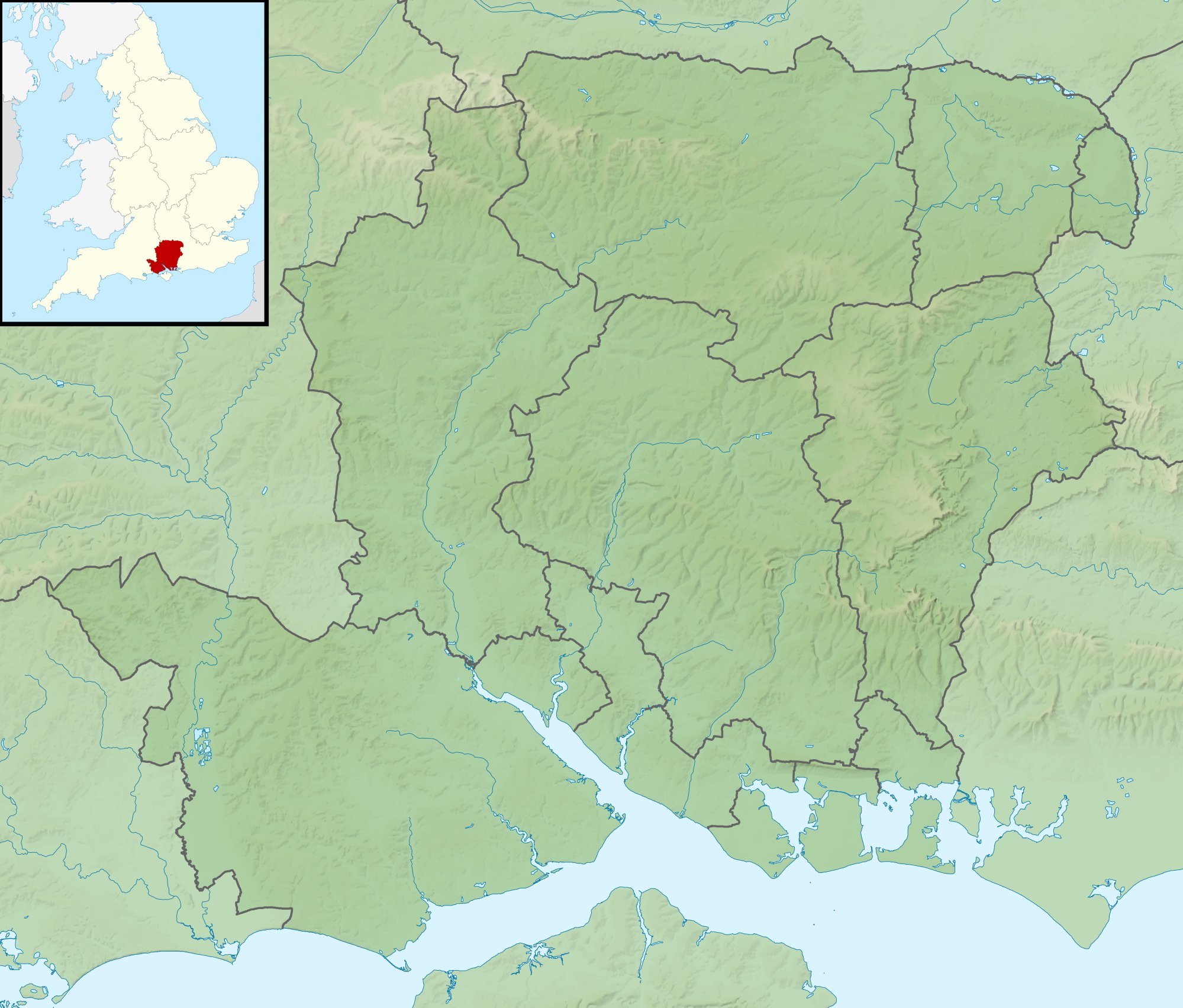
Equirectangular map projection on WGS 84 datum, with N/S stretched 155%
876:
723:
703:
693:
653:
139:
576:
195:
Administrative borders and coastline data from
Boundary-Line product.
851:
525:
Click on a date/time to view the file as it appeared at that time.
271:
Contains
Ordnance Survey data © Crown copyright and database right
901:
886:
906:
896:
1066:
1026:
891:
1061:
171:
88:
364:
Add a one-line explanation of what this file represents
937:
Module:Location map/data/United
Kingdom Hampshire/doc
866:
759:
Module:Location map/data/United
Kingdom Hampshire/doc
587:
78:(1,999 × 1,702 pixels, file size: 407 KB, MIME type:
1071:
1001:
967:モジュール:Location map/data/United Kingdom Hampshire/doc
767:
523:
466:
Creative
Commons Attribution-ShareAlike 3.0 Unported
440:
Creative
Commons Attribution-ShareAlike 3.0 Unported
112:
Commons is a freely licensed media file repository.
856:
198:All other geographic data from Meridian 2 product.
932:Module:Location map/data/United Kingdom Hampshire
754:Module:Location map/data/United Kingdom Hampshire
962:モジュール:Location map/data/United Kingdom Hampshire
977:ಟೆಂಪ್ಲೇಟು:Location map United Kingdom Hampshire
842:Plantilya:Location map United Kingdom Hampshire
957:Template:Location map United Kingdom Hampshire
317:https://creativecommons.org/licenses/by-sa/3.0
93:
323:Creative Commons Attribution-Share Alike 3.0
241:
226:
167:
130:
336:
215:
192:Relief data from Land-Form Panorama product.
177:
14:
862:Plantilla:Mapa de localización de Hampshire
283:– to copy, distribute and transmit the work
777:قالب:Location map United Kingdom Hampshire
639:Gosport and Fareham Inshore Rescue Service
341:File:Hampshire UK district map (blank).svg
769:The following other wikis use this file:
575:{{Information |Description=Relief map of
947:Module:Location map/data/Hampshire/doc
927:Module:Location map/data/हैम्पशायर/doc
124:
987:Formula:Charta locatrix Hantoniensis
912:Forêt de Pamber et Silchester Common
264:Attribution-Share Alike 3.0 Unported
222:, created using Ordnance Survey data
133:Hampshire UK relief location map.jpg
516:
252:
247:
13:
942:Module:Location map/data/Hampshire
922:Module:Location map/data/हैम्पशायर
749:Module:Location map/data/Hampshire
369:
363:
238:
125:
71:
1112:
689:Portsmouth and Southsea Synagogue
368:
882:Modèle:Géolocalisation/Hampshire
822:Шаблон:ПК Великобритания Хампшър
588:
354:
294:Under the following conditions:
259:This file is licensed under the
251:
246:
240:
92:
31:
21:
1047:Bitwa morska w cieśninie Solent
1022:Sjabloon:Positiekaart Hampshire
734:William Ogle, 1st Viscount Ogle
644:Hayling Island Lifeboat Station
351:
764:
520:
350:
26:
1:
659:List of hillforts in England
584:
376:Items portrayed in this file
7:
997:Veidne:VietasKarte Hempšīra
838:Usage on ceb.wikipedia.org
684:Portsmouth Lifeboat Station
10:
1117:
1083:Usage on pl.wikibooks.org
1043:Usage on pl.wikipedia.org
1033:Usage on os.wikipedia.org
1018:Usage on nl.wikipedia.org
1008:Usage on mk.wikipedia.org
993:Usage on lv.wikipedia.org
983:Usage on la.wikipedia.org
973:Usage on kn.wikipedia.org
953:Usage on ja.wikipedia.org
918:Usage on hi.wikipedia.org
873:Usage on fr.wikipedia.org
848:Usage on es.wikipedia.org
783:Usage on bg.wikipedia.org
773:Usage on ar.wikipedia.org
308:same or compatible license
127:
1092:Moduł:Mapa/dane/Hampshire
1077:Itchen (dopływ La Manche)
1052:Moduł:Mapa/dane/Hampshire
517:
16:
674:Philips PFA Golf Classic
624:Calshot Lifeboat Station
353:
274:
203:England location map.svg
99:This is a file from the
36:
1012:Шаблон:ПолКарта Хемпшир
574:
553:01:39, 29 November 2011
170:
103:. Information from its
1087:Moduł:Mapa/dane/GB-HAM
1057:Moduł:Mapa/dane/GB-HAM
852:Faro de Punta de Hurst
106:description page there
41:Size of this preview:
877:Déroute de Winchester
714:Siege of Basing House
709:River Slea, Hampshire
679:Pilot Hill, Hampshire
594:Avon Water, Hampshire
614:Battle of the Solent
65:1,999 × 1,702 pixels
61:1,203 × 1,024 pixels
902:Anneaux de Buckland
887:Circuit de Thruxton
289:– to adapt the work
201:Inset derived from
148:Geographic limits:
47:Other resolutions:
907:Abbaye de Wherwell
897:Bataille de Basing
739:User:Que/hillforts
629:Dark Water (river)
609:Battle of Cheriton
1101:more global usage
765:Global file usage
582:
450:copyright license
436:copyright license
362:
347:
346:
235:
232:Reusing this file
121:
120:
101:Wikimedia Commons
32:Global file usage
1108:
744:User:Que/sandbox
565:
527:
505:29 November 2010
406:copyright status
392:copyright status
360:
330:
327:
324:
321:
318:
310:as the original.
272:
261:Creative Commons
255:
254:
250:
249:
244:
243:
229:
173:
172:29 November 2010
134:
128:
117:
96:
95:
89:
83:
81:
68:
57:902 × 768 pixels
53:564 × 480 pixels
49:282 × 240 pixels
43:704 × 599 pixels
1116:
1115:
1111:
1110:
1109:
1107:
1106:
1105:
1067:Portsea (wyspa)
763:
664:Lymington River
649:Humphrey Bennet
604:Battle of Alton
590:
583:
571:
563:
519:
518:
515:
514:
513:
512:
511:
510:
509:
508:
506:
496:
495:
494:
492:
477:
476:
475:
474:
473:
472:
471:
470:
468:
456:
455:
454:
452:
433:
432:
431:
430:
429:
428:
427:
426:
424:
412:
411:
410:
408:
389:
388:
387:
386:
385:
383:
367:
366:
365:
348:
332:
331:
328:
325:
322:
319:
316:
315:
273:
270:
267:
256:
183:Ordnance Survey
132:
123:
122:
111:
110:
109:is shown below.
85:
79:
77:
70:
69:
46:
12:
11:
5:
1114:
1103:of this file.
1097:
1096:
1095:
1094:
1089:
1081:
1080:
1079:
1074:
1069:
1064:
1059:
1054:
1049:
1041:
1040:
1039:
1031:
1030:
1029:
1027:Portsea Island
1024:
1016:
1015:
1014:
1006:
1005:
1004:
999:
991:
990:
989:
981:
980:
979:
971:
970:
969:
964:
959:
951:
950:
949:
944:
939:
934:
929:
924:
916:
915:
914:
909:
904:
899:
894:
892:Hayling Island
889:
884:
879:
871:
870:
869:
864:
859:
854:
846:
845:
844:
836:
835:
834:
829:
824:
819:
814:
809:
804:
799:
794:
789:
781:
780:
779:
766:
762:
761:
756:
751:
746:
741:
736:
731:
726:
721:
716:
711:
706:
701:
696:
691:
686:
681:
676:
671:
666:
661:
656:
651:
646:
641:
636:
631:
626:
621:
616:
611:
606:
601:
596:
586:
581:
580:
573:
569:
566:
562:1,999 × 1,702
560:
555:
550:
546:
545:
542:
539:
536:
533:
530:
522:
507:
504:
502:
501:
500:
498:
497:
493:
488:
486:
485:
484:
483:
481:
469:
464:
462:
461:
460:
458:
457:
453:
448:
446:
445:
444:
443:
441:
437:
425:
420:
418:
417:
416:
414:
413:
409:
404:
402:
401:
400:
399:
397:
393:
384:
379:
377:
374:
373:
372:
371:
359:
358:
355:
352:
345:
344:
338:
337:Other versions
334:
333:
314:
313:
312:
311:
301:
292:
291:
290:
284:
277:You are free:
268:
258:
257:
239:
236:
224:
223:
217:
213:
212:
211:
210:
199:
196:
193:
179:
175:
174:
169:
165:
164:
163:
162:
159:
156:
153:
138:Relief map of
135:
126:
119:
118:
97:
87:
86:
40:
35:
34:
29:
24:
19:
9:
6:
4:
3:
2:
1113:
1104:
1102:
1093:
1090:
1088:
1085:
1084:
1082:
1078:
1075:
1073:
1070:
1068:
1065:
1063:
1060:
1058:
1055:
1053:
1050:
1048:
1045:
1044:
1042:
1038:
1035:
1034:
1032:
1028:
1025:
1023:
1020:
1019:
1017:
1013:
1010:
1009:
1007:
1003:
1000:
998:
995:
994:
992:
988:
985:
984:
982:
978:
975:
974:
972:
968:
965:
963:
960:
958:
955:
954:
952:
948:
945:
943:
940:
938:
935:
933:
930:
928:
925:
923:
920:
919:
917:
913:
910:
908:
905:
903:
900:
898:
895:
893:
890:
888:
885:
883:
880:
878:
875:
874:
872:
868:
865:
863:
860:
858:
855:
853:
850:
849:
847:
843:
840:
839:
837:
833:
830:
828:
825:
823:
820:
818:
815:
813:
810:
808:
805:
803:
800:
798:
795:
793:
790:
788:
785:
784:
782:
778:
775:
774:
772:
771:
770:
760:
757:
755:
752:
750:
747:
745:
742:
740:
737:
735:
732:
730:
727:
725:
722:
720:
719:Solent Rescue
717:
715:
712:
710:
707:
705:
702:
700:
697:
695:
692:
690:
687:
685:
682:
680:
677:
675:
672:
670:
667:
665:
662:
660:
657:
655:
652:
650:
647:
645:
642:
640:
637:
635:
632:
630:
627:
625:
622:
620:
617:
615:
612:
610:
607:
605:
602:
600:
599:Bartley Water
597:
595:
592:
591:
578:
572:
567:
561:
559:
556:
554:
551:
548:
547:
543:
540:
537:
534:
531:
529:
528:
526:
503:
491:
487:
467:
463:
451:
447:
423:
419:
407:
403:
382:
378:
375:
356:
349:
342:
339:
335:
320:CC BY-SA 3.0
309:
305:
302:
299:
296:
295:
293:
288:
285:
282:
279:
278:
276:
275:
269:Attribution:
265:
262:
245:
237:
233:
228:
225:
221:
218:
214:
208:
204:
200:
197:
194:
191:
190:
189:
187:
184:
180:
176:
166:
161:South: 50.68N
160:
158:North: 51.41N
157:
154:
151:
150:
149:
146:
143:
141:
136:
129:
115:
108:
107:
102:
98:
91:
90:
84:
75:
74:Original file
66:
62:
58:
54:
50:
44:
39:
33:
30:
28:
25:
23:
20:
18:
15:
1098:
1062:Test (rzeka)
768:
729:Twyford Down
699:River Hamble
524:
521:File history
303:
297:
286:
280:
181:
147:
144:
137:
114:You can help
104:
72:
22:File history
792:Саутхамптън
669:Monks Brook
634:Fleet Brook
619:Butser Hill
422:copyrighted
396:copyrighted
343:- Blank map
304:share alike
298:attribution
155:East: 0.68W
152:West: 2.01W
131:Description
832:Питърсфилд
724:The Solent
704:River Hart
694:River Alre
654:Ladle Hill
585:File usage
538:Dimensions
227:Permission
80:image/jpeg
27:File usage
812:Стивънтън
787:Уинчестър
577:Hampshire
570:Nilfanion
535:Thumbnail
532:Date/Time
490:inception
480:inception
220:Nilfanion
140:Hampshire
867:Spithead
807:Нърслинг
797:Портсмът
564:(407 KB)
357:Captions
287:to remix
281:to share
266:license.
207:Spischot
186:OpenData
1072:Hayling
1037:Гэмпшир
1002:Solents
549:current
544:Comment
381:depicts
361:English
76:
857:Solent
827:Одихем
216:Author
178:Source
142:, UK.
1099:View
817:Чотън
802:Олтън
541:User
329:true
326:true
168:Date
17:File
205:by
188:.
63:|
59:|
55:|
51:|
45:.
234:)
230:(
209:.
116:.
82:)
67:.
.svg)