43:
654:"}},"text\/plain":{"en":{"":"inception"}}},"{\"value\":{\"time\":\"+2010-09-21T00:00:00Z\",\"timezone\":0,\"before\":0,\"after\":0,\"precision\":11,\"calendarmodel\":\"http:\\\/\\\/www.wikidata.org\\\/entity\\\/Q1985727\"},\"type\":\"time\"}":{"text\/html":{"en":{"P571":"21 September 2010"}},"text\/plain":{"en":{"P571":"21 September 2010"}}}}": -->
554:
261:
103:
299:
574:"}},"text\/plain":{"en":{"":"determination method"}}},"{\"value\":{\"entity-type\":\"item\",\"numeric-id\":60671452,\"id\":\"Q60671452\"},\"type\":\"wikibase-entityid\"}":{"text\/html":{"en":{"P459":"
570:"}},"text\/plain":{"en":{"P1001":"United States of America"}}},"{\"value\":{\"entity-type\":\"property\",\"numeric-id\":459,\"id\":\"P459\"},\"type\":\"wikibase-entityid\"}":{"text\/html":{"en":{"":"
566:"}},"text\/plain":{"en":{"":"applies to jurisdiction"}}},"{\"value\":{\"entity-type\":\"item\",\"numeric-id\":30,\"id\":\"Q30\"},\"type\":\"wikibase-entityid\"}":{"text\/html":{"en":{"P1001":"
558:"}},"text\/plain":{"en":{"":"copyright status"}}},"{\"value\":{\"entity-type\":\"item\",\"numeric-id\":19652,\"id\":\"Q19652\"},\"type\":\"wikibase-entityid\"}":{"text\/html":{"en":{"P6216":"
562:"}},"text\/plain":{"en":{"P6216":"public domain"}}},"{\"value\":{\"entity-type\":\"property\",\"numeric-id\":1001,\"id\":\"P1001\"},\"type\":\"wikibase-entityid\"}":{"text\/html":{"en":{"":"
650:
187:
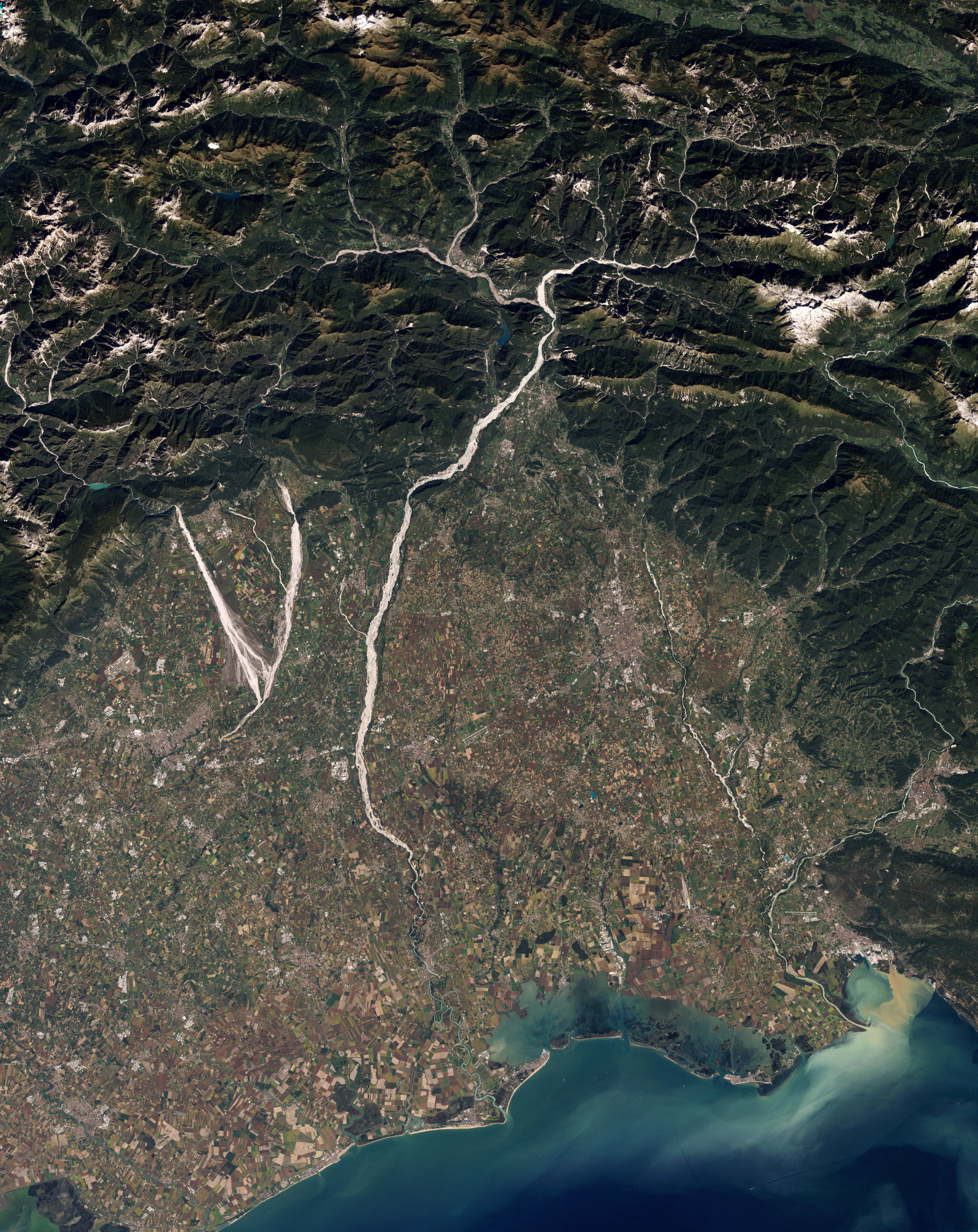
Immagine a colori naturali del nord-est dell'Italia (Regione Friuli-Venezia Giulia) che mostra i torrenti
Cellina e Meduna ed il fiume Tagliamento. I letti ghiaiosi di questi corsi d'acqua contrastano con il terreno circostante, rendendoli immediatamente riconoscibili. Il Cellina ed il Meduna formano
165:
shape. When a river receives more sediment than it can move effectively, the river changes shape, often carving braided channels. Upstream from the
Cellina, Meduna, and Tagliamento Rivers, the mountain basin is seismically active and prone to landslides. As a result, heavy sediment loads often reach
178:
belong to cultivated fields. The crops mingle with settlements, some of them quite close to river channels. Some hydrologists have expressed concern about continued development on this floodplain because flood damage has occurred fairly frequently, just as the fertile soils have attracted
188:
alla loro confluenza la grande V sulla sinistra. Il grande accumulo di materiale ghiaioso è dovuto anche all'instabilità idrogeologica e tettonica dei bacini montani di questi fiumi: nel caso del
Tagliamento di conseguenza si è sviluppata una morfologia fluviale a canali intrecciati (
192:). La dinamica naturale qui visibile è messa a rischio dalla costruzione di dighe (principalmente nel caso del Cellina), dal prelievo di ghiaia, dal trattenimento dei sedimenti a monte, e dallo sviluppo di coltivazioni ed insediamenti all'interno dell'alveo naturale.
403:
575:
559:
161:-coated riverbeds contrast sharply with the surrounding landscape, highlighting the river contours. The Cellina and Meduna Rivers converge in the south, forming a giant
563:
555:
651:
571:
567:
69:
65:
61:
57:
53:
47:
114:
82:
748:
747:{{Information |Description={{en|1=Natural-colour image of north-eastern Italy showing parts of the Cellina, Meduna, and Tagliamento rivers. The
578:"}},"text\/plain":{"en":{"P459":"work of the federal government of the United States"}}}}": -->
382:
joint project implies that all materials created by its probe are copyrighted and require permission for commercial non-educational use.
331:
636:
941:
This file contains additional information, probably added from the digital camera or scanner used to create or digitize it.
228:
Image captured by the
Thematic Mapper on NASA’s Landsat 5 satellite. Data provided by the United States Geological Survey.
601:
399:
379:
614:
585:
357:
661:
629:
544:
621:
157:
Natural-colour image of north-eastern Italy showing parts of the
Cellina, Meduna, and Tagliamento rivers. The
1025:
389:
342:
944:
If the file has been modified from its original state, some details may not fully reflect the modified file.
908:
898:
828:
729:
724:
73:
42:
407:
410:
states that all of the images in the photo gallery are in the public domain "Unless otherwise noted."
761:
The following pages on the
English Knowledge use this file (pages on other projects are not listed):
353:
166:
these rivers, all three of which have braided channels. Around the rivers, rectangular shapes of
122:
430:
383:
338:
211:
8:
394:
370:
364:
286:
282:
740:
109:
751:-coated riverbeds contrast sharply with the surrounding landscape, highlighting the
534:
158:
888:
783:
277:. NASA copyright policy states that "NASA material is not protected by copyright
269:
671:
595:
1040:
765:
290:
327:
697:
Click on a date/time to view the file as it appeared at that time.
361:
356:
data may be copyrighted if they are not explicitly produced by the
878:
175:
167:
848:
808:
274:
171:
868:
337:
The NASA website hosts a large number of images from the
201:
97:
858:
838:
803:
793:
528:
Add a one-line explanation of what this file represents
162:
273:
in the United States because it was solely created by
759:
87:(3,199 × 4,031 pixels, file size: 4.2 MB, MIME type:
928:
774:
695:
121:
Commons is a freely licensed media file repository.
918:
863:
818:
637:
work of the federal government of the United States
576:
work of the federal government of the United States
345:, and other non-American space agencies. These are
504:
479:
454:
330:, insignia and emblems is restricted per U.S. law
501:
476:
451:
507:
482:
457:
102:
498:
495:
492:
489:
473:
470:
467:
464:
448:
445:
442:
439:
197:
144:
217:
207:
14:
488:
463:
438:
776:The following other wikis use this file:
147:Gravel Rivers in Northeastern Italy.jpg
260:
133:
418:
402:(NSSDC) site has been known to host
393:(APOD) web site may be copyrighted.
255:
688:
13:
939:
533:
527:
400:National Space Science Data Center
308:
297:
181:
151:
134:
80:
1057:
946:
532:
760:
518:
259:
101:
31:
21:
515:
431:View the annotations at Commons
182:
152:
771:
692:
514:
26:
1:
1026:Adobe Photoshop CS4 Macintosh
36:
756:
540:Items portrayed in this file
390:Astronomy Picture of the Day
231:
7:
936:
915:Usage on vec.wikipedia.org
10:
1062:
925:Usage on www.wikidata.org
905:Usage on uk.wikipedia.org
895:Usage on ru.wikipedia.org
885:Usage on os.wikipedia.org
875:Usage on oc.wikipedia.org
855:Usage on no.wikipedia.org
845:Usage on it.wikiquote.org
835:Usage on it.wikipedia.org
825:Usage on hy.wikipedia.org
815:Usage on eo.wikipedia.org
800:Usage on de.wikipedia.org
790:Usage on ca.wikipedia.org
780:Usage on ar.wikipedia.org
287:NASA copyright policy page
141:
136:
1032:File change date and time
689:
428:This image is annotated:
16:
622:United States of America
568:United States of America
517:
108:This is a file from the
41:
746:
725:10:13, 13 December 2010
615:applies to jurisdiction
564:applies to jurisdiction
387:Images featured on the
200:
112:. Information from its
1035:16:36, 9 December 2010
354:Hubble Space Telescope
313:
302:
212:NASA Earth Observatory
115:description page there
46:Size of this preview:
998:Horizontal resolution
380:SOHO (ESA & NASA)
349:in the public domain.
312:
301:
990:Number of components
630:determination method
572:determination method
343:Russian space agency
291:JPL Image Use Policy
267:This file is in the
74:3,199 × 4,031 pixels
70:1,625 × 2,048 pixels
1006:Vertical resolution
404:copyrighted content
352:Materials based on
52:Other resolutions:
966:Compression scheme
509:Tagliamento River
314:
303:
66:813 × 1,024 pixels
1049:
1048:
974:Pixel composition
849:Proverbi friulani
772:Global file usage
754:
677:21 September 2010
526:
437:
436:
417:
416:
408:photo gallery FAQ
321:
283:Template:PD-USGov
254:
253:
225:
224:
202:21 September 2010
130:
129:
110:Wikimedia Commons
32:Global file usage
1053:
1014:Data arrangement
947:
809:Motta di Livenza
737:
699:
639:
634:
624:
619:
586:copyright status
556:copyright status
524:
419:
373:
367:
317:
311:
300:
263:
262:
256:
250:
247:
244:
241:
236:
235:
203:
186:
156:
148:
142:
126:
105:
104:
98:
92:
90:
77:
62:609 × 768 pixels
58:381 × 480 pixels
54:190 × 240 pixels
48:476 × 600 pixels
1061:
1060:
1056:
1055:
1054:
1052:
1051:
1050:
935:
770:
762:
755:
743:
735:
691:
690:
687:
686:
685:
684:
683:
682:
681:
680:
678:
668:
667:
666:
664:
649:
648:
647:
646:
645:
644:
643:
642:
641:
640:
635:
632:
626:
625:
620:
617:
608:
607:
606:
604:
592:
591:
590:
588:
553:
552:
551:
550:
549:
547:
531:
530:
529:
512:
511:
506:
503:
500:
497:
494:
491:
487:
486:
481:
478:
475:
472:
469:
466:
462:
461:
456:
453:
450:
447:
444:
441:
425:
413:
371:
365:
347:not necessarily
309:
298:
248:
245:
242:
239:
234:
226:
193:
180:
146:
139:
132:
131:
120:
119:
118:is shown below.
94:
88:
86:
79:
78:
51:
12:
11:
5:
1059:
1047:
1046:
1043:
1037:
1036:
1033:
1029:
1028:
1023:
1019:
1018:
1015:
1011:
1010:
1007:
1003:
1002:
999:
995:
994:
991:
987:
986:
983:
979:
978:
975:
971:
970:
967:
963:
962:
959:
955:
954:
951:
938:
934:
933:
932:
931:
923:
922:
921:
913:
912:
911:
903:
902:
901:
893:
892:
891:
883:
882:
881:
879:Friol (Itàlia)
873:
872:
871:
869:Forgreinet elv
866:
861:
853:
852:
851:
843:
842:
841:
833:
832:
831:
823:
822:
821:
813:
812:
811:
806:
798:
797:
796:
788:
787:
786:
773:
769:
768:
758:
753:
752:
745:
741:
738:
734:3,199 × 4,031
732:
727:
722:
718:
717:
714:
711:
708:
705:
702:
694:
679:
676:
674:
673:
672:
670:
669:
665:
660:
658:
657:
656:
655:
653:
628:
627:
613:
612:
611:
610:
609:
605:
600:
598:
597:
596:
594:
593:
589:
584:
582:
581:
580:
579:
577:
573:
569:
565:
561:
557:
548:
543:
541:
538:
537:
536:
535:
523:
522:
519:
516:
459:Cellina River
435:
434:
426:
423:
415:
414:
412:
411:
396:
385:
376:
350:
335:
323:
315:
305:
304:
295:
264:
252:
251:
233:
230:
223:
222:
219:
215:
214:
209:
205:
204:
199:
195:
194:
149:
140:
138:
135:
128:
127:
106:
96:
95:
45:
40:
39:
34:
29:
24:
19:
9:
6:
4:
3:
2:
1058:
1044:
1042:
1039:
1038:
1034:
1031:
1030:
1027:
1024:
1022:Software used
1021:
1020:
1017:chunky format
1016:
1013:
1012:
1008:
1005:
1004:
1000:
997:
996:
992:
989:
988:
984:
981:
980:
976:
973:
972:
968:
965:
964:
960:
957:
956:
952:
949:
948:
945:
942:
930:
927:
926:
924:
920:
917:
916:
914:
910:
907:
906:
904:
900:
897:
896:
894:
890:
887:
886:
884:
880:
877:
876:
874:
870:
867:
865:
862:
860:
857:
856:
854:
850:
847:
846:
844:
840:
837:
836:
834:
830:
827:
826:
824:
820:
817:
816:
814:
810:
807:
805:
802:
801:
799:
795:
792:
791:
789:
785:
782:
781:
779:
778:
777:
767:
764:
763:
750:
744:
739:
733:
731:
728:
726:
723:
720:
719:
715:
712:
709:
706:
703:
701:
700:
698:
675:
663:
659:
638:
631:
623:
616:
603:
602:public domain
599:
587:
583:
560:public domain
546:
542:
539:
520:
513:
510:
485:
484:Meduna River
460:
433:
432:
427:
421:
420:
409:
405:
401:
397:
395:
392:
391:
386:
384:
381:
377:
374:
372:{{Cc-Hubble}}
368:
366:{{PD-Hubble}}
362:
359:
355:
351:
348:
344:
340:
336:
333:
329:
325:
324:
322:
320:
316:
307:
306:
296:
294:
292:
288:
284:
280:
276:
272:
271:
270:public domain
265:
258:
257:
243:Public domain
240:Public domain
238:
237:
229:
221:Robert Simmon
220:
216:
213:
210:
206:
196:
191:
185:
177:
173:
169:
164:
160:
155:
150:
143:
124:
117:
116:
111:
107:
100:
99:
93:
84:
83:Original file
75:
71:
67:
63:
59:
55:
49:
44:
38:
35:
33:
30:
28:
25:
23:
20:
18:
15:
1045:Uncalibrated
943:
940:
775:
742:Originalwana
696:
693:File history
508:
483:
458:
429:
388:
346:
318:
279:unless noted
278:
268:
266:
227:
189:
183:
153:
123:You can help
113:
81:
22:File history
1041:Color space
982:Orientation
859:Tagliamento
839:Tagliamento
804:Tagliamento
766:Tagliamento
422:Annotations
332:14 CFR 1221
145:Description
909:Тальяменто
899:Тальяменто
829:Տալյամենտո
757:File usage
710:Dimensions
328:NASA logos
184:Italiano:
89:image/jpeg
27:File usage
707:Thumbnail
704:Date/Time
662:inception
652:inception
424:InfoField
363:See also
319:Warnings:
232:Licensing
154:English:
961:4,031 px
953:4,031 px
937:Metadata
736:(4.2 MB)
521:Captions
281:". (See
179:farmers.
37:Metadata
929:Q160570
721:current
716:Comment
545:depicts
525:English
326:Use of
190:braided
137:Summary
85:
1009:72 dpi
1001:72 dpi
985:Normal
958:Height
889:Фриули
864:Meduna
819:Friulo
784:فريولي
749:gravel
406:. Its
339:Soviet
218:Author
208:Source
174:, and
159:gravel
950:Width
919:Friul
794:Friül
358:STScI
249:false
246:false
176:brown
168:green
713:User
505:4031
502:3199
493:1968
490:1230
480:4031
477:3199
468:1821
455:4031
452:3199
443:2009
398:The
378:The
369:and
275:NASA
198:Date
172:gold
17:File
977:RGB
969:LZW
465:948
440:712
289:or
633::
618::
499:54
496:54
474:54
471:54
449:54
446:54
293:.)
285:,
170:,
72:|
68:|
64:|
60:|
56:|
50:.
993:4
375:.
360:.
341:/
334:.
163:V
125:.
91:)
76:.
Text is available under the Creative Commons Attribution-ShareAlike License. Additional terms may apply.