837:"}},"text\/plain":{"en":{"":"coordinates of the point of view"}}},"{\"value\":{\"latitude\":57.4838,\"longitude\":-5.339,\"altitude\":null,\"precision\":0.0001,\"globe\":\"http:\\\/\\\/www.wikidata.org\\\/entity\\\/Q2\"},\"type\":\"globecoordinate\"}":{"text\/html":{"en":{"P1259":"57\u00b029'1.7"N, 5\u00b020'20.4"W"}},"text\/plain":{"en":{"P1259":"57\u00b029'1.7\"N, 5\u00b020'20.4\"W"}}},"{\"value\":{\"entity-type\":\"property\",\"numeric-id\":7787,\"id\":\"P7787\"},\"type\":\"wikibase-entityid\"}":{"text\/html":{"en":{"":"
905:"}},"text\/plain":{"en":{"":"coordinates of depicted place"}}},"{\"value\":{\"latitude\":57.4837,\"longitude\":-5.342,\"altitude\":null,\"precision\":0.0001,\"globe\":\"http:\\\/\\\/www.wikidata.org\\\/entity\\\/Q2\"},\"type\":\"globecoordinate\"}":{"text\/html":{"en":{"P9149":"57\u00b029'1.3"N, 5\u00b020'31.2"W"}},"text\/plain":{"en":{"P9149":"57\u00b029'1.3\"N, 5\u00b020'31.2\"W"}}},"{\"value\":{\"entity-type\":\"property\",\"numeric-id\":7787,\"id\":\"P7787\"},\"type\":\"wikibase-entityid\"}":{"text\/html":{"en":{"":"
497:"}},"text\/plain":{"en":{"":"author name string"}}},"{\"value\":\"David Maclennan\",\"type\":\"string\"}":{"text\/html":{"en":{"P2093":"David Maclennan"}},"text\/plain":{"en":{"P2093":"David Maclennan"}}},"{\"value\":{\"entity-type\":\"property\",\"numeric-id\":3831,\"id\":\"P3831\"},\"type\":\"wikibase-entityid\"}":{"text\/html":{"en":{"":"
680:"}},"text\/plain":{"en":{"":"inception"}}},"{\"value\":{\"time\":\"+2006-07-15T00:00:00Z\",\"timezone\":0,\"before\":0,\"after\":0,\"precision\":11,\"calendarmodel\":\"http:\\\/\\\/www.wikidata.org\\\/entity\\\/Q1985727\"},\"type\":\"time\"}":{"text\/html":{"en":{"P571":"15 July 2006"}},"text\/plain":{"en":{"P571":"15 July 2006"}}}}": -->
714:
481:
232:
901:
224:
296:
246:
317:
355:
360:
72:
493:"}},"text\/plain":{"en":{"P2699":"https:\/\/www.geograph.org.uk\/profile\/5383"}}},"{\"value\":{\"entity-type\":\"property\",\"numeric-id\":2093,\"id\":\"P2093\"},\"type\":\"wikibase-entityid\"}":{"text\/html":{"en":{"":"
722:"}},"text\/plain":{"en":{"P7482":"file available on the internet"}}},"{\"value\":{\"entity-type\":\"property\",\"numeric-id\":137,\"id\":\"P137\"},\"type\":\"wikibase-entityid\"}":{"text\/html":{"en":{"":"
730:"}},"text\/plain":{"en":{"P137":"Geograph Britain and Ireland"}}},"{\"value\":{\"entity-type\":\"property\",\"numeric-id\":7384,\"id\":\"P7384\"},\"type\":\"wikibase-entityid\"}":{"text\/html":{"en":{"":"
501:"}},"text\/plain":{"en":{"":"object of statement has role"}}},"{\"value\":{\"entity-type\":\"item\",\"numeric-id\":33231,\"id\":\"Q33231\"},\"type\":\"wikibase-entityid\"}":{"text\/html":{"en":{"P3831":"
636:"}},"text\/plain":{"en":{"":"copyright license"}}},"{\"value\":{\"entity-type\":\"item\",\"numeric-id\":19068220,\"id\":\"Q19068220\"},\"type\":\"wikibase-entityid\"}":{"text\/html":{"en":{"P275":"
592:"}},"text\/plain":{"en":{"":"copyright status"}}},"{\"value\":{\"entity-type\":\"item\",\"numeric-id\":50423863,\"id\":\"Q50423863\"},\"type\":\"wikibase-entityid\"}":{"text\/html":{"en":{"P6216":"
718:"}},"text\/plain":{"en":{"":"source of file"}}},"{\"value\":{\"entity-type\":\"item\",\"numeric-id\":74228490,\"id\":\"Q74228490\"},\"type\":\"wikibase-entityid\"}":{"text\/html":{"en":{"P7482":"
1011:
909:"}},"text\/plain":{"en":{"":"heading"}}},"{\"value\":{\"amount\":\"+270\",\"unit\":\"http:\\\/\\\/www.wikidata.org\\\/entity\\\/Q28390\"},\"type\":\"quantity\"}":{"text\/html":{"en":{"P7787":"270
841:"}},"text\/plain":{"en":{"":"heading"}}},"{\"value\":{\"amount\":\"+270\",\"unit\":\"http:\\\/\\\/www.wikidata.org\\\/entity\\\/Q28390\"},\"type\":\"quantity\"}":{"text\/html":{"en":{"P7787":"270
726:"}},"text\/plain":{"en":{"":"operator"}}},"{\"value\":{\"entity-type\":\"item\",\"numeric-id\":1503119,\"id\":\"Q1503119\"},\"type\":\"wikibase-entityid\"}":{"text\/html":{"en":{"P137":"
738:"}},"text\/plain":{"en":{"P7384":"203418"}}},"{\"value\":{\"entity-type\":\"property\",\"numeric-id\":973,\"id\":\"P973\"},\"type\":\"wikibase-entityid\"}":{"text\/html":{"en":{"":"
485:"}},"text\/plain":{"en":{"":"creator"}}},"{\"value\":{\"entity-type\":\"property\",\"numeric-id\":2699,\"id\":\"P2699\"},\"type\":\"wikibase-entityid\"}":{"text\/html":{"en":{"":"
588:
489:"}},"text\/plain":{"en":{"":"URL"}}},"{\"value\":\"https:\\\/\\\/www.geograph.org.uk\\\/profile\\\/5383\",\"type\":\"string\"}":{"text\/html":{"en":{"P2699":"
265:
734:"}},"text\/plain":{"en":{"":"geograph.org.uk image ID"}}},"{\"value\":\"203418\",\"type\":\"string\"}":{"text\/html":{"en":{"P7384":"
215:
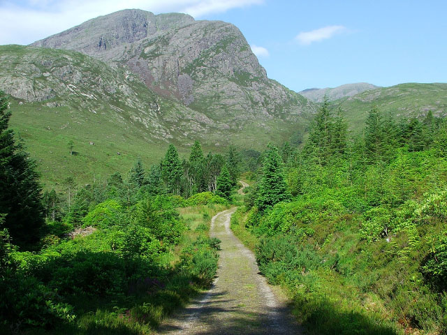
1028:== {{int:filedesc}} == {{Information |description={{en|1=Footpath above Achnashellach. This path runs from Achnashellach to Torridon via Coire Lair. The mountain in the near distance is Fuar Tholl, and the mountain in the far distance, with just the top b
126:
Footpath above
Achnashellach. This path runs from Achnashellach to Torridon via Coire Lair. The mountain in the near distance is Fuar Tholl, and the mountain in the far distance, with just the top being visible is Beinn Liath
407:– You must give appropriate credit, provide a link to the license, and indicate if changes were made. You may do so in any reasonable manner, but not in any way that suggests the licensor endorses you or your use.
279:
229:
83:
51:
735:
719:
637:
593:
727:
502:
906:
902:
838:
834:
731:
715:
589:
498:
494:
486:
743:
739:
723:
677:
633:
490:
482:
1021:
640:"}},"text\/plain":{"en":{"P275":"Creative Commons Attribution-ShareAlike 2.0 Generic"}}}}": -->
746:"}},"text\/plain":{"en":{"P973":"https:\/\/www.geograph.org.uk\/photo\/203418"}}}}": -->
769:
663:
619:
289:
239:
789:
1010:
1005:
324:
42:
1078:
This file contains additional information, probably added from the digital camera or scanner used to create or digitize it.
414:
574:
947:
920:
879:
852:
797:
753:
603:
567:
554:
539:
812:
782:
687:
647:
512:
471:
1047:
1215:
370:
1081:
If the file has been modified from its original state, some details may not fully reflect the modified file.
1184:
413:– If you remix, transform, or build upon the material, you must distribute your contributions under the
331:
on the
Geograph website for the photographer's contact details. The copyright on this image is owned by
505:"}},"text\/plain":{"en":{"P3831":"photographer"}}}}": -->
596:"}},"text\/plain":{"en":{"P6216":"copyrighted"}}}}": -->
1038:
The following pages on the
English Knowledge use this file (pages on other projects are not listed):
913:"}},"text\/plain":{"en":{"P7787":"270 degree"}}}}": -->
845:"}},"text\/plain":{"en":{"P7787":"270 degree"}}}}": -->
1042:
91:
184:
1268:
819:
804:
546:
367:
168:
8:
1304:
311:
295:
245:
336:
78:
461:
1372:
1286:
1242:
1107:
1100:
1147:
157:
147:
1314:
930:
862:
763:
697:
657:
613:
522:
316:
1127:
328:
1390:
1117:
1090:
978:
Click on a date/time to view the file as it appeared at that time.
281:
231:
116:
52:
Footpath_above_Achnashellach_-_geograph.org.uk_-_203418.jpg
266:
57° 29′ 01″ N, 5° 20′ 31″ W
216:
57° 29′ 02″ N, 5° 20′ 20″ W
136:
66:
455:
Add a one-line explanation of what this file represents
1065:
1036:
1056:
976:
90:
Commons is a freely licensed media file repository.
664:
Creative
Commons Attribution-ShareAlike 2.0 Generic
638:
Creative
Commons Attribution-ShareAlike 2.0 Generic
56:(640 × 480 pixels, file size: 162 KB, MIME type:
1309:Flash did not fire, compulsory flash suppression
424:https://creativecommons.org/licenses/by-sa/2.0
71:
430:Creative Commons Attribution-Share Alike 2.0
348:
132:
113:
744:https:\/\/www.geograph.org.uk\/photo\/203418
491:https:\/\/www.geograph.org.uk\/profile\/5383
153:
142:
14:
910:
842:
390:– to copy, distribute and transmit the work
1058:The following other wikis use this file:
820:https://www.geograph.org.uk/photo/203418
547:https://www.geograph.org.uk/profile/5383
288:View this and other nearby images on:
238:View this and other nearby images on:
191:
102:
335:and is licensed for reuse under the
256:
206:
969:
371:Attribution-Share Alike 2.0 Generic
359:
354:
339:Attribution-ShareAlike 2.0 license.
13:
1076:
460:
454:
345:
322:
120:
103:
49:
1415:
1083:
459:
1138:Date and time of data generation
1037:
853:coordinates of the point of view
835:coordinates of the point of view
445:
401:Under the following conditions:
366:This file is licensed under the
358:
353:
347:
315:
294:
280:
272:
244:
230:
222:
70:
31:
21:
1048:List of wars involving Scotland
442:
121:
46:No higher resolution available.
1112:1/350 sec (0.0028571428571429)
1053:
973:
770:file available on the internet
720:file available on the internet
441:
323:This image was taken from the
26:
1:
921:coordinates of depicted place
903:coordinates of depicted place
36:
1033:
790:Geograph Britain and Ireland
728:Geograph Britain and Ireland
568:object of statement has role
499:object of statement has role
467:Items portrayed in this file
307:
271:
221:
199:Footpath above Achnashellach
197:David Maclennan /
180:Footpath above Achnashellach
178:David Maclennan /
7:
1340:Focal plane resolution unit
1226:Date and time of digitizing
1185:Adobe Photoshop CS2 Windows
1073:
10:
1420:
1351:One-chip color area sensor
1062:Usage on www.wikidata.org
415:same or compatible license
110:
105:
1191:File change date and time
970:
16:
1332:Focal plane Y resolution
1324:Focal plane X resolution
936:57°29'1.3"N, 5°20'31.2"W
868:57°29'1.7"N, 5°20'20.4"W
798:geograph.org.uk image ID
732:geograph.org.uk image ID
444:
381:
77:This is a file from the
41:
1356:Custom image processing
1043:Battle of Achnashellach
1027:
169:required by the license
135:
81:. Information from its
1400:Subject distance range
1234:Image compression mode
1006:18:58, 31 January 2010
329:this photograph's page
300:57.483700; -5.342000
250:57.483800; -5.339000
84:description page there
1278:Maximum land aperture
1165:Horizontal resolution
1377:Manual white balance
1229:09:49, 15 July 2006
1199:Y and C positioning
1194:09:59, 17 July 2006
1173:Vertical resolution
1141:09:49, 15 July 2006
1087:Camera manufacturer
396:– to adapt the work
1382:Scene capture type
555:author name string
495:author name string
1407:
1406:
1054:Global file usage
1031:
912:
844:
648:copyright license
634:copyright license
453:
344:
343:
327:collection. See
305:
304:
255:
254:
204:
203:
172:
99:
98:
79:Wikimedia Commons
32:Global file usage
1411:
1207:Exposure Program
1084:
1018:
980:
958:
957:
952:
890:
889:
884:
822:
817:
813:described at URL
807:
802:
792:
787:
740:described at URL
604:copyright status
590:copyright status
577:
572:
562:
559:
549:
544:
451:
437:
434:
431:
428:
425:
417:as the original.
379:
368:Creative Commons
362:
361:
357:
356:
351:
350:
337:Creative Commons
325:Geograph project
319:
312:
301:
298:
284:
283:
277:
276:
275:
269:
268:
257:
251:
248:
234:
233:
227:
226:
225:
219:
218:
207:
166:
138:
125:
117:
111:
95:
74:
73:
67:
61:
59:
1419:
1418:
1414:
1413:
1412:
1410:
1409:
1408:
1281:3 APEX (f/2.83)
1260:APEX brightness
1101:FinePix S5500
1072:
1052:
1039:
1032:
1024:
1016:
972:
971:
968:
967:
966:
965:
964:
963:
962:
961:
960:
959:
955:
953:
950:
941:
940:
939:
937:
927:
926:
925:
923:
900:
899:
898:
897:
896:
895:
894:
893:
892:
891:
887:
885:
882:
873:
872:
871:
869:
859:
858:
857:
855:
832:
831:
830:
829:
828:
827:
826:
825:
824:
823:
818:
815:
809:
808:
803:
800:
794:
793:
788:
785:
776:
775:
774:
772:
760:
759:
758:
756:
713:
712:
711:
710:
709:
708:
707:
706:
704:
694:
693:
692:
690:
675:
674:
673:
672:
671:
670:
669:
668:
666:
654:
653:
652:
650:
631:
630:
629:
628:
627:
626:
625:
624:
622:
610:
609:
608:
606:
587:
586:
585:
584:
583:
582:
581:
580:
579:
578:
573:
570:
564:
563:
561:David Maclennan
560:
557:
551:
550:
545:
542:
533:
532:
531:
529:
519:
518:
517:
515:
480:
479:
478:
477:
476:
474:
458:
457:
456:
439:
438:
435:
432:
429:
426:
423:
422:
380:
378:David Maclennan
377:
374:
363:
340:
333:David Maclennan
310:
299:
273:
264:
263:
260:Object location
249:
223:
214:
213:
210:Camera location
205:
194:
187:
175:
158:David Maclennan
148:geograph.org.uk
128:
115:
108:
101:
100:
89:
88:
87:is shown below.
63:
57:
55:
48:
47:
12:
11:
5:
1417:
1405:
1404:
1401:
1397:
1396:
1393:
1387:
1386:
1383:
1379:
1378:
1375:
1369:
1368:
1365:
1361:
1360:
1359:Custom process
1357:
1353:
1352:
1349:
1348:Sensing method
1345:
1344:
1341:
1337:
1336:
1333:
1329:
1328:
1325:
1321:
1320:
1317:
1311:
1310:
1307:
1301:
1300:
1297:
1293:
1292:
1289:
1283:
1282:
1279:
1275:
1274:
1271:
1265:
1264:
1261:
1257:
1256:
1253:
1249:
1248:
1245:
1239:
1238:
1235:
1231:
1230:
1227:
1223:
1222:
1219:
1212:
1211:
1210:Normal program
1208:
1204:
1203:
1200:
1196:
1195:
1192:
1188:
1187:
1182:
1178:
1177:
1174:
1170:
1169:
1166:
1162:
1161:
1158:
1154:
1153:
1150:
1143:
1142:
1139:
1135:
1134:
1131:
1124:
1123:
1120:
1114:
1113:
1110:
1104:
1103:
1098:
1094:
1093:
1088:
1075:
1071:
1070:
1069:
1068:
1055:
1051:
1050:
1045:
1035:
1030:
1029:
1026:
1022:
1019:
1013:
1008:
1003:
999:
998:
995:
992:
989:
986:
983:
975:
946:
945:
944:
943:
942:
938:
935:
933:
932:
931:
929:
928:
924:
919:
917:
916:
915:
914:
908:
904:
878:
877:
876:
875:
874:
870:
867:
865:
864:
863:
861:
860:
856:
851:
849:
848:
847:
846:
840:
836:
811:
810:
796:
795:
781:
780:
779:
778:
777:
773:
768:
766:
765:
764:
762:
761:
757:
754:source of file
752:
750:
749:
748:
747:
745:
741:
737:
733:
729:
725:
721:
717:
716:source of file
705:
702:
700:
699:
698:
696:
695:
691:
686:
684:
683:
682:
681:
679:
667:
662:
660:
659:
658:
656:
655:
651:
646:
644:
643:
642:
641:
639:
635:
623:
618:
616:
615:
614:
612:
611:
607:
602:
600:
599:
598:
597:
595:
591:
566:
565:
553:
552:
538:
537:
536:
535:
534:
530:
527:
525:
524:
523:
521:
520:
516:
511:
509:
508:
507:
506:
504:
500:
496:
492:
488:
484:
475:
470:
468:
465:
464:
463:
462:
450:
449:
446:
443:
421:
420:
419:
418:
408:
399:
398:
397:
391:
384:You are free:
375:
365:
364:
346:
342:
341:
320:
309:
306:
303:
302:
292:
286:
261:
253:
252:
242:
236:
211:
202:
201:
195:
192:
189:
188:
183:
176:
173:
161:
160:
155:
151:
150:
144:
140:
139:
134:
130:
129:
118:
109:
107:
104:
97:
96:
75:
65:
64:
45:
40:
39:
34:
29:
24:
19:
9:
6:
4:
3:
2:
1416:
1402:
1399:
1398:
1394:
1392:
1389:
1388:
1384:
1381:
1380:
1376:
1374:
1373:White balance
1371:
1370:
1367:Auto exposure
1366:
1364:Exposure mode
1363:
1362:
1358:
1355:
1354:
1350:
1347:
1346:
1342:
1339:
1338:
1334:
1331:
1330:
1326:
1323:
1322:
1318:
1316:
1313:
1312:
1308:
1306:
1303:
1302:
1298:
1295:
1294:
1290:
1288:
1287:Metering mode
1285:
1284:
1280:
1277:
1276:
1272:
1270:
1269:Exposure bias
1267:
1266:
1262:
1259:
1258:
1254:
1252:APEX aperture
1251:
1250:
1246:
1244:
1243:Shutter speed
1241:
1240:
1236:
1233:
1232:
1228:
1225:
1224:
1220:
1217:
1214:
1213:
1209:
1206:
1205:
1201:
1198:
1197:
1193:
1190:
1189:
1186:
1183:
1181:Software used
1180:
1179:
1175:
1172:
1171:
1167:
1164:
1163:
1159:
1156:
1155:
1151:
1149:
1145:
1144:
1140:
1137:
1136:
1132:
1129:
1126:
1125:
1121:
1119:
1116:
1115:
1111:
1109:
1108:Exposure time
1106:
1105:
1102:
1099:
1096:
1095:
1092:
1089:
1086:
1085:
1082:
1079:
1067:
1064:
1063:
1061:
1060:
1059:
1049:
1046:
1044:
1041:
1040:
1025:
1020:
1014:
1012:
1009:
1007:
1004:
1001:
1000:
996:
993:
990:
987:
984:
982:
981:
979:
949:
934:
922:
918:
881:
866:
854:
850:
821:
814:
806:
799:
791:
784:
771:
767:
755:
751:
701:
689:
685:
665:
661:
649:
645:
621:
617:
605:
601:
576:
569:
556:
548:
541:
526:
514:
510:
473:
469:
466:
447:
440:
427:CC BY-SA 2.0
416:
412:
409:
406:
403:
402:
400:
395:
392:
389:
386:
385:
383:
382:
376:Attribution:
372:
369:
352:
338:
334:
330:
326:
321:
318:
314:
313:
297:
293:
291:
290:OpenStreetMap
287:
285:
267:
262:
259:
258:
247:
243:
241:
240:OpenStreetMap
237:
235:
217:
212:
209:
208:
200:
196:
190:
186:
182: /
181:
177:
170:
165:
163:
162:
159:
156:
152:
149:
145:
141:
131:
124:
119:
112:
93:
86:
85:
80:
76:
69:
68:
62:
53:
44:
38:
35:
33:
30:
28:
25:
23:
20:
18:
15:
1296:Light source
1148:focal length
1097:Camera model
1080:
1077:
1057:
977:
974:File history
703:15 July 2006
575:photographer
503:photographer
410:
404:
393:
387:
332:
270:
220:
198:
185:CC BY-SA 2.0
179:
137:15 July 2006
122:
92:You can help
82:
50:
22:File history
1315:Color space
1157:Orientation
1023:GeographBot
620:copyrighted
594:copyrighted
411:share alike
405:attribution
164:Attribution
114:Description
1034:File usage
1015:640 × 480
991:Dimensions
528:some value
58:image/jpeg
27:File usage
1391:Sharpness
1128:ISO speed
988:Thumbnail
985:Date/Time
688:inception
678:inception
308:Licensing
193:InfoField
174:InfoField
123:English:
1385:Standard
1299:Daylight
1202:Co-sited
1118:F-number
1091:FUJIFILM
1074:Metadata
1066:Q4870214
1017:(162 KB)
783:operator
724:operator
448:Captions
394:to remix
388:to share
373:license.
37:Metadata
1403:Unknown
1291:Average
1218:version
1002:current
997:Comment
948:heading
907:heading
880:heading
839:heading
513:creator
483:creator
472:depicts
452:English
106:Summary
54:
1395:Normal
1176:72 dpi
1168:72 dpi
1160:Normal
1152:7.5 mm
1130:rating
956:degree
911:degree
888:degree
843:degree
805:203418
736:203418
278:
228:
154:Author
143:Source
1335:4,255
1327:4,255
1305:Flash
1146:Lens
146:From
127:Mhor.
1319:sRGB
1263:8.15
1247:8.56
1216:Exif
994:User
954:270
886:270
436:true
433:true
133:Date
17:File
1221:2.2
1122:f/4
540:URL
487:URL
1133:64
951::
883::
816::
801::
786::
571::
558::
543::
1343:3
1273:0
1255:4
1237:4
171:)
167:(
94:.
60:)
Text is available under the Creative Commons Attribution-ShareAlike License. Additional terms may apply.
_heading:270.00&language=en)
_heading:270.00&language=en)
