418:"}},"text\/plain":{"en":{"":"coordinates of the point of view"}}},"{\"value\":{\"latitude\":63.1,\"longitude\":-101.2639,\"altitude\":null,\"precision\":0.1,\"globe\":\"http:\\\/\\\/www.wikidata.org\\\/entity\\\/Q2\"},\"type\":\"globecoordinate\"}":{"text\/html":{"en":{"P1259":"63\u00b06'N, 101\u00b018'W"}},"text\/plain":{"en":{"P1259":"63\u00b06'N, 101\u00b018'W"}}}}": -->
380:"}},"text\/plain":{"en":{"":"inception"}}},"{\"value\":{\"time\":\"+2011-12-10T00:00:00Z\",\"timezone\":0,\"before\":0,\"after\":0,\"precision\":11,\"calendarmodel\":\"http:\\\/\\\/www.wikidata.org\\\/entity\\\/Q1985727\"},\"type\":\"time\"}":{"text\/html":{"en":{"P571":"10 December 2011"}},"text\/plain":{"en":{"P571":"10 December 2011"}}}}": -->
141:
155:
325:
247:
86:
562:
414:
494:
138:
132:
415:
377:
622:
148:
425:
542:
387:
366:
662:
552:
52:
48:
42:
97:
65:
314:
520:
The following pages on the
English Knowledge use this file (pages on other projects are not listed):
105:
572:
8:
154:
268:
using a public domain layer, such as Blue Marble, MODIS, Landsat, SRTM, USGS or GLOBE.
92:
356:
504:
493:
488:
56:
37:
682:
652:
632:
582:
256:
309:
524:
435:
397:
305:
301:
297:
293:
289:
285:
281:
277:
273:
265:
461:
Click on a date/time to view the file as it appeared at that time.
140:
642:
133:
63° 06′ 00″ N, 101° 15′ 50.04″ W
261:
612:
602:
191:
80:
592:
350:
Add a one-line explanation of what this file represents
672:
518:
533:
459:
104:
Commons is a freely licensed media file repository.
70:(730 × 859 pixels, file size: 239 KB, MIME type:
85:
573:Dubawnt Lake (lanaw sa Northwest Territories)
187:
169:
205:
197:
14:
535:The following other wikis use this file:
147:View this and other nearby images on:
246:
116:
563:ক্ষেত্রফল অনুযায়ী হ্রদসমূহের তালিকা
240:
123:
452:
13:
355:
349:
323:
176:
117:
63:
696:
354:
519:
426:coordinates of the point of view
416:coordinates of the point of view
340:
260:because it is a screenshot from
245:
153:
139:
84:
31:
21:
633:Pasaules lielāko ezeru saraksts
337:
530:
456:
336:
177:
26:
1:
515:
362:Items portrayed in this file
216:
7:
569:Usage on ceb.wikipedia.org
539:Usage on arz.wikipedia.org
10:
701:
679:Usage on zh.wikipedia.org
669:Usage on www.wikidata.org
659:Usage on uk.wikipedia.org
649:Usage on ru.wikipedia.org
639:Usage on pl.wikipedia.org
629:Usage on lv.wikipedia.org
619:Usage on ka.wikipedia.org
609:Usage on it.wikipedia.org
599:Usage on es.wikipedia.org
589:Usage on de.wikipedia.org
579:Usage on cv.wikipedia.org
559:Usage on bn.wikipedia.org
549:Usage on bg.wikipedia.org
166:
119:
453:
16:
339:
91:This is a file from the
36:
510:
489:02:51, 11 December 2011
190:
95:. Information from its
328:
159:63.100000; -101.263900
98:description page there
41:Size of this preview:
327:
254:This image is in the
182:Lac Dubawnt, Nunavut
47:Other resolutions:
329:
264:’s globe software
643:Dubawnt (jezioro)
531:Global file usage
513:
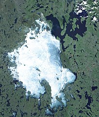
348:
334:
333:
317:
239:
238:
213:
212:
164:
163:
113:
112:
93:Wikimedia Commons
32:Global file usage
692:
501:
463:
441:63°6'N, 101°18'W
403:10 December 2011
346:
326:
318:
313:
249:
248:
241:
235:
232:
229:
226:
221:
220:
193:
192:10 December 2011
181:
179:Français :
173:
172:Dubawnt Lake.jpg
167:
160:
157:
143:
142:
136:
135:
124:
109:
88:
87:
81:
75:
73:
60:
57:730 × 859 pixels
53:408 × 480 pixels
49:204 × 240 pixels
43:509 × 599 pixels
700:
699:
695:
694:
693:
691:
690:
689:
529:
521:
514:
507:
499:
455:
454:
451:
450:
449:
448:
447:
446:
445:
444:
442:
432:
431:
430:
428:
413:
412:
411:
410:
409:
408:
407:
406:
404:
394:
393:
392:
390:
375:
374:
373:
372:
371:
369:
353:
352:
351:
330:
324:
272:
250:
233:
230:
227:
224:
219:
214:
183:
171:
158:
131:
130:
127:Camera location
122:
115:
114:
103:
102:
101:is shown below.
77:
71:
69:
62:
61:
46:
12:
11:
5:
698:
688:
687:
686:
685:
677:
676:
675:
667:
666:
665:
663:Дубонт (озеро)
657:
656:
655:
647:
646:
645:
637:
636:
635:
627:
626:
625:
617:
616:
615:
607:
606:
605:
597:
596:
595:
587:
586:
585:
577:
576:
575:
567:
566:
565:
557:
556:
555:
553:Дубонт (езеро)
547:
546:
545:
532:
528:
527:
517:
512:
511:
509:
505:
502:
496:
491:
486:
482:
481:
478:
475:
472:
469:
466:
458:
443:
440:
438:
437:
436:
434:
433:
429:
424:
422:
421:
420:
419:
417:
405:
402:
400:
399:
398:
396:
395:
391:
386:
384:
383:
382:
381:
379:
370:
365:
363:
360:
359:
358:
357:
345:
344:
341:
338:
332:
331:
322:
320:
251:
244:
237:
236:
218:
215:
211:
210:
207:
203:
202:
201:Nasa WorldWind
199:
195:
194:
189:
185:
184:
174:
165:
162:
161:
151:
145:
128:
121:
118:
111:
110:
89:
79:
78:
40:
35:
34:
29:
24:
19:
9:
6:
4:
3:
2:
697:
684:
681:
680:
678:
674:
671:
670:
668:
664:
661:
660:
658:
654:
651:
650:
648:
644:
641:
640:
638:
634:
631:
630:
628:
624:
621:
620:
618:
614:
611:
610:
608:
604:
601:
600:
598:
594:
591:
590:
588:
584:
581:
580:
578:
574:
571:
570:
568:
564:
561:
560:
558:
554:
551:
550:
548:
544:
543:بحيره دوباونت
541:
540:
538:
537:
536:
526:
523:
522:
508:
503:
497:
495:
492:
490:
487:
484:
483:
479:
476:
473:
470:
467:
465:
464:
462:
439:
427:
423:
401:
389:
385:
368:
364:
361:
342:
335:
321:
319:
316:
311:
307:
303:
299:
295:
291:
287:
283:
279:
275:
270:
269:
267:
263:
259:
258:
257:public domain
252:
243:
242:
228:Public domain
225:Public domain
223:
222:
208:
204:
200:
196:
186:
180:
175:
168:
156:
152:
150:
149:OpenStreetMap
146:
144:
134:
129:
126:
125:
107:
100:
99:
94:
90:
83:
82:
76:
67:
66:Original file
58:
54:
50:
44:
39:
33:
30:
28:
25:
23:
20:
18:
15:
623:დუბონტის ტბა
613:Lago Dubawnt
603:Lago Dubawnt
534:
525:Dubawnt Lake
460:
457:File history
271:
255:
253:
178:
106:You can help
96:
64:
22:File history
506:SamuelFreli
170:Description
593:Dubawntsee
516:File usage
498:730 × 859
474:Dimensions
302:Nederlands
294:македонски
266:World Wind
72:image/jpeg
27:File usage
471:Thumbnail
468:Date/Time
388:inception
378:inception
310:中文(中国大陆)
274:العربيَّة
217:Licensing
673:Q1262967
500:(239 KB)
343:Captions
312: |
308: |
304: |
300: |
296: |
292: |
288: |
286:français
284: |
280: |
276: |
485:current
480:Comment
367:depicts
347:English
306:русский
278:English
120:Summary
68:
653:Дубонт
583:Дубонт
298:മലയാളം
206:Author
198:Source
137:
290:עברית
282:فارسی
234:false
231:false
683:杜邦特湖
477:User
262:NASA
209:NASA
188:Date
17:File
315:+/−
55:|
51:|
45:.
108:.
74:)
59:.
Text is available under the Creative Commons Attribution-ShareAlike License. Additional terms may apply.
