812:"}},"text\/plain":{"en":{"":"coordinates of depicted place"}}},"{\"value\":{\"latitude\":54.7665,\"longitude\":-4.544,\"altitude\":null,\"precision\":0.0001,\"globe\":\"http:\\\/\\\/www.wikidata.org\\\/entity\\\/Q2\"},\"type\":\"globecoordinate\"}":{"text\/html":{"en":{"P9149":"54\u00b045'59.4"N, 4\u00b032'38.4"W"}},"text\/plain":{"en":{"P9149":"54\u00b045'59.4\"N, 4\u00b032'38.4\"W"}}}}": -->
43:
472:"}},"text\/plain":{"en":{"":"author name string"}}},"{\"value\":\"Roger W Haworth\",\"type\":\"string\"}":{"text\/html":{"en":{"P2093":"Roger W Haworth"}},"text\/plain":{"en":{"P2093":"Roger W Haworth"}}},"{\"value\":{\"entity-type\":\"property\",\"numeric-id\":3831,\"id\":\"P3831\"},\"type\":\"wikibase-entityid\"}":{"text\/html":{"en":{"":"
655:"}},"text\/plain":{"en":{"":"inception"}}},"{\"value\":{\"time\":\"+2005-05-21T00:00:00Z\",\"timezone\":0,\"before\":0,\"after\":0,\"precision\":11,\"calendarmodel\":\"http:\\\/\\\/www.wikidata.org\\\/entity\\\/Q1985727\"},\"type\":\"time\"}":{"text\/html":{"en":{"P571":"21 May 2005"}},"text\/plain":{"en":{"P571":"21 May 2005"}}}}": -->
689:
456:
268:
292:
330:
335:
99:
895:"}},"text\/plain":{"en":{"":"f-number"}}},"{\"value\":{\"amount\":\"+2.9\",\"unit\":\"1\"},\"type\":\"quantity\"}":{"text\/html":{"en":{"P6790":"2.9"}},"text\/plain":{"en":{"P6790":"2.9"}}}}": -->
978:"}},"text\/plain":{"en":{"":"ISO speed"}}},"{\"value\":{\"amount\":\"+50\",\"unit\":\"1\"},\"type\":\"quantity\"}":{"text\/html":{"en":{"P6789":"50"}},"text\/plain":{"en":{"P6789":"50"}}}}": -->
468:"}},"text\/plain":{"en":{"P2699":"https:\/\/www.geograph.org.uk\/profile\/3860"}}},"{\"value\":{\"entity-type\":\"property\",\"numeric-id\":2093,\"id\":\"P2093\"},\"type\":\"wikibase-entityid\"}":{"text\/html":{"en":{"":"
1166:
697:"}},"text\/plain":{"en":{"P7482":"file available on the internet"}}},"{\"value\":{\"entity-type\":\"property\",\"numeric-id\":137,\"id\":\"P137\"},\"type\":\"wikibase-entityid\"}":{"text\/html":{"en":{"":"
850:"}},"text\/plain":{"en":{"":"exposure time"}}},"{\"value\":{\"amount\":\"+0.0015625\",\"unit\":\"http:\\\/\\\/www.wikidata.org\\\/entity\\\/Q11574\"},\"type\":\"quantity\"}":{"text\/html":{"en":{"P6757":"0.0015625
705:"}},"text\/plain":{"en":{"P137":"Geograph Britain and Ireland"}}},"{\"value\":{\"entity-type\":\"property\",\"numeric-id\":7384,\"id\":\"P7384\"},\"type\":\"wikibase-entityid\"}":{"text\/html":{"en":{"":"
476:"}},"text\/plain":{"en":{"":"object of statement has role"}}},"{\"value\":{\"entity-type\":\"item\",\"numeric-id\":33231,\"id\":\"Q33231\"},\"type\":\"wikibase-entityid\"}":{"text\/html":{"en":{"P3831":"
1016:"}},"text\/plain":{"en":{"":"media type"}}},"{\"value\":\"image\\\/jpeg\",\"type\":\"string\"}":{"text\/html":{"en":{"P1163":"image\/jpeg"}},"text\/plain":{"en":{"P1163":"image\/jpeg"}}}}": -->
611:"}},"text\/plain":{"en":{"":"copyright license"}}},"{\"value\":{\"entity-type\":\"item\",\"numeric-id\":19068220,\"id\":\"Q19068220\"},\"type\":\"wikibase-entityid\"}":{"text\/html":{"en":{"P275":"
567:"}},"text\/plain":{"en":{"":"copyright status"}}},"{\"value\":{\"entity-type\":\"item\",\"numeric-id\":50423863,\"id\":\"Q50423863\"},\"type\":\"wikibase-entityid\"}":{"text\/html":{"en":{"P6216":"
693:"}},"text\/plain":{"en":{"":"source of file"}}},"{\"value\":{\"entity-type\":\"item\",\"numeric-id\":74228490,\"id\":\"Q74228490\"},\"type\":\"wikibase-entityid\"}":{"text\/html":{"en":{"P7482":"
933:"}},"text\/plain":{"en":{"":"focal length"}}},"{\"value\":{\"amount\":\"+5.8\",\"unit\":\"http:\\\/\\\/www.wikidata.org\\\/entity\\\/Q174789\"},\"type\":\"quantity\"}":{"text\/html":{"en":{"P2151":"5.8
1136:
1054:"}},"text\/plain":{"en":{"":"instance of"}}},"{\"value\":{\"entity-type\":\"item\",\"numeric-id\":125191,\"id\":\"Q125191\"},\"type\":\"wikibase-entityid\"}":{"text\/html":{"en":{"P31":"
701:"}},"text\/plain":{"en":{"":"operator"}}},"{\"value\":{\"entity-type\":\"item\",\"numeric-id\":1503119,\"id\":\"Q1503119\"},\"type\":\"wikibase-entityid\"}":{"text\/html":{"en":{"P137":"
713:"}},"text\/plain":{"en":{"P7384":"91414"}}},"{\"value\":{\"entity-type\":\"property\",\"numeric-id\":973,\"id\":\"P973\"},\"type\":\"wikibase-entityid\"}":{"text\/html":{"en":{"":"
460:"}},"text\/plain":{"en":{"":"creator"}}},"{\"value\":{\"entity-type\":\"property\",\"numeric-id\":2699,\"id\":\"P2699\"},\"type\":\"wikibase-entityid\"}":{"text\/html":{"en":{"":"
1012:
382:– You must give appropriate credit, provide a link to the license, and indicate if changes were made. You may do so in any reasonable manner, but not in any way that suggests the licensor endorses you or your use.
251:
65:
61:
57:
53:
47:
110:
78:
694:
612:
568:
710:
702:
1055:
477:
1013:
975:
930:
892:
847:
809:
706:
690:
564:
473:
469:
461:
714:
698:
652:
608:
465:
457:
718:
1051:
1176:
1165:
1160:
1202:
615:"}},"text\/plain":{"en":{"P275":"Creative Commons Attribution-ShareAlike 2.0 Generic"}}}}": -->
1347:
721:"}},"text\/plain":{"en":{"P973":"https:\/\/www.geograph.org.uk\/photo\/91414"}}}}": -->
744:
638:
594:
261:
764:
299:
1233:
This file contains additional information, probably added from the digital camera or scanner used to create or digitize it.
1081:
1135:
1130:
389:
69:
42:
549:
1023:
985:
944:
902:
861:
819:
772:
728:
578:
542:
529:
514:
787:
757:
662:
622:
487:
446:
1065:
157:
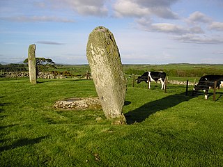
explains that the middle stone may have been deliberately flattened to 'Christianise' what was a pagan monument.
1378:
345:
1236:
If the file has been modified from its original state, some details may not fully reflect the modified file.
854:"}},"text\/plain":{"en":{"P6757":"0.0015625 second"}}}}": -->
1197:
937:"}},"text\/plain":{"en":{"P2151":"5.8 millimetre"}}}}": -->
388:– If you remix, transform, or build upon the material, you must distribute your contributions under the
306:
on the
Geograph website for the photographer's contact details. The copyright on this image is owned by
480:"}},"text\/plain":{"en":{"P3831":"photographer"}}}}": -->
571:"}},"text\/plain":{"en":{"P6216":"copyrighted"}}}}": -->
1193:
The following pages on the
English Knowledge use this file (pages on other projects are not listed):
1058:"}},"text\/plain":{"en":{"P31":"photograph"}}}}": -->
118:
214:
1405:
521:
342:
198:
794:
779:
8:
1441:
1253:
286:
267:
1506:
311:
105:
436:
1263:
1477:
1423:
1270:
1146:
1516:
1487:
1310:
187:
154:
177:
1451:
1075:
1033:
995:
954:
912:
871:
829:
738:
672:
632:
588:
497:
291:
1290:
303:
1526:
1280:
1103:
Click on a date/time to view the file as it appeared at that time.
253:
246:
54° 45′ 59″ N, 4° 32′ 38″ W
166:
143:
Drumtroddan standing stones - geograph.org.uk - 91414.jpg
93:
430:
Add a one-line explanation of what this file represents
1220:
1191:
83:(1,600 × 1,200 pixels, file size: 401 KB, MIME type:
1211:
1101:
117:
Commons is a freely licensed media file repository.
639:
Creative
Commons Attribution-ShareAlike 2.0 Generic
613:
Creative
Commons Attribution-ShareAlike 2.0 Generic
1446:Flash did not fire, compulsory flash suppression
1203:List of Historic Environment Scotland properties
399:https://creativecommons.org/licenses/by-sa/2.0
98:
405:Creative Commons Attribution-Share Alike 2.0
323:
162:
140:
466:https:\/\/www.geograph.org.uk\/profile\/3860
183:
172:
14:
934:
851:
719:https:\/\/www.geograph.org.uk\/photo\/91414
365:– to copy, distribute and transmit the work
1213:The following other wikis use this file:
522:https://www.geograph.org.uk/profile/3860
795:https://www.geograph.org.uk/photo/91414
260:View this and other nearby images on:
221:
129:
310:and is licensed for reuse under the
236:
1094:
346:Attribution-Share Alike 2.0 Generic
334:
329:
314:Attribution-ShareAlike 2.0 license.
13:
1231:
435:
429:
320:
297:
147:
130:
76:
1543:
1238:
434:
1301:Date and time of data generation
1192:
420:
376:Under the following conditions:
341:This file is licensed under the
333:
328:
322:
290:
266:
252:
97:
31:
21:
1245:OLYMPUS DIGITAL CAMERA
417:
148:
1208:
1098:
745:file available on the internet
695:file available on the internet
416:
298:This image was taken from the
26:
1:
820:coordinates of depicted place
810:coordinates of depicted place
153:Drumtroddan standing stones.
36:
1188:
765:Geograph Britain and Ireland
703:Geograph Britain and Ireland
543:object of statement has role
474:object of statement has role
442:Items portrayed in this file
282:
227:Roger W Haworth /
208:Roger W Haworth /
7:
1389:Date and time of digitizing
1228:
1198:Drumtroddan standing stones
229:Drumtroddan standing stones
210:Drumtroddan standing stones
10:
1548:
1217:Usage on www.wikidata.org
390:same or compatible license
137:
132:
1354:File change date and time
1095:
835:54°45'59.4"N, 4°32'38.4"W
16:
773:geograph.org.uk image ID
707:geograph.org.uk image ID
419:
356:
104:This is a file from the
41:
1461:Custom image processing
1182:
1152:
199:required by the license
165:
108:. Information from its
1397:Image compression mode
1161:22:03, 30 January 2010
304:this photograph's page
272:54.766500; -4.544000
111:description page there
46:Size of this preview:
1415:Maximum land aperture
1328:Horizontal resolution
1275:1/640 sec (0.0015625)
1131:23:50, 17 March 2010
70:1,600 × 1,200 pixels
1362:Y and C positioning
1336:Vertical resolution
1254:OLYMPUS CORPORATION
1250:Camera manufacturer
371:– to adapt the work
52:Other resolutions:
1498:Scene capture type
1482:Auto white balance
1392:19:35, 21 May 2005
1357:19:35, 21 May 2005
1304:19:35, 21 May 2005
530:author name string
470:author name string
66:1,280 × 960 pixels
62:1,024 × 768 pixels
1535:
1534:
1418:2.9 APEX (f/2.73)
1209:Global file usage
1186:
936:
853:
623:copyright license
609:copyright license
428:
319:
318:
302:collection. See
277:
276:
234:
233:
202:
126:
125:
106:Wikimedia Commons
32:Global file usage
1539:
1370:Exposure Program
1264:X100,D540Z,C310Z
1239:
1173:
1143:
1105:
963:
880:
797:
792:
788:described at URL
782:
777:
767:
762:
715:described at URL
579:copyright status
565:copyright status
552:
547:
537:
534:
524:
519:
426:
412:
409:
406:
403:
400:
392:as the original.
354:
343:Creative Commons
337:
336:
332:
331:
326:
325:
312:Creative Commons
300:Geograph project
294:
287:
273:
270:
256:
255:
249:
248:
237:
196:
168:
152:
144:
138:
122:
101:
100:
94:
88:
86:
73:
58:640 × 480 pixels
54:320 × 240 pixels
48:800 × 600 pixels
1547:
1546:
1542:
1541:
1540:
1538:
1537:
1536:
1227:
1207:
1194:
1187:
1179:
1171:
1149:
1141:
1097:
1096:
1093:
1092:
1091:
1090:
1089:
1088:
1087:
1086:
1084:
1072:
1071:
1070:
1068:
1049:
1048:
1047:
1046:
1045:
1044:
1043:
1042:
1040:
1030:
1029:
1028:
1026:
1011:
1010:
1009:
1008:
1007:
1006:
1005:
1004:
1002:
992:
991:
990:
988:
973:
972:
971:
970:
969:
968:
967:
966:
964:
961:
951:
950:
949:
947:
928:
927:
926:
925:
924:
923:
922:
921:
919:
909:
908:
907:
905:
890:
889:
888:
887:
886:
885:
884:
883:
881:
878:
868:
867:
866:
864:
845:
844:
843:
842:
841:
840:
839:
838:
836:
826:
825:
824:
822:
807:
806:
805:
804:
803:
802:
801:
800:
799:
798:
793:
790:
784:
783:
778:
775:
769:
768:
763:
760:
751:
750:
749:
747:
735:
734:
733:
731:
688:
687:
686:
685:
684:
683:
682:
681:
679:
669:
668:
667:
665:
650:
649:
648:
647:
646:
645:
644:
643:
641:
629:
628:
627:
625:
606:
605:
604:
603:
602:
601:
600:
599:
597:
585:
584:
583:
581:
562:
561:
560:
559:
558:
557:
556:
555:
554:
553:
548:
545:
539:
538:
536:Roger W Haworth
535:
532:
526:
525:
520:
517:
508:
507:
506:
504:
494:
493:
492:
490:
455:
454:
453:
452:
451:
449:
433:
432:
431:
414:
413:
410:
407:
404:
401:
398:
397:
355:
353:Roger W Haworth
352:
349:
338:
315:
308:Roger W Haworth
285:
271:
244:
243:
240:Object location
235:
224:
217:
205:
188:Roger W Haworth
178:geograph.org.uk
158:
142:
135:
128:
127:
116:
115:
114:is shown below.
90:
84:
82:
75:
74:
51:
12:
11:
5:
1545:
1533:
1532:
1529:
1523:
1522:
1519:
1513:
1512:
1509:
1503:
1502:
1499:
1495:
1494:
1491:
1484:
1483:
1480:
1474:
1473:
1470:
1466:
1465:
1464:Normal process
1462:
1458:
1457:
1454:
1448:
1447:
1444:
1438:
1437:
1434:
1430:
1429:
1426:
1420:
1419:
1416:
1412:
1411:
1408:
1402:
1401:
1398:
1394:
1393:
1390:
1386:
1385:
1382:
1375:
1374:
1373:Normal program
1371:
1367:
1366:
1363:
1359:
1358:
1355:
1351:
1350:
1345:
1341:
1340:
1337:
1333:
1332:
1329:
1325:
1324:
1321:
1317:
1316:
1313:
1306:
1305:
1302:
1298:
1297:
1294:
1287:
1286:
1283:
1277:
1276:
1273:
1267:
1266:
1261:
1257:
1256:
1251:
1247:
1246:
1243:
1230:
1226:
1225:
1224:
1223:
1210:
1206:
1205:
1200:
1190:
1185:
1184:
1181:
1177:
1174:
1168:
1163:
1158:
1155:
1154:
1151:
1147:
1144:
1140:1,600 × 1,200
1138:
1133:
1128:
1124:
1123:
1120:
1117:
1114:
1111:
1108:
1100:
1085:
1080:
1078:
1077:
1076:
1074:
1073:
1069:
1064:
1062:
1061:
1060:
1059:
1057:
1053:
1041:
1038:
1036:
1035:
1034:
1032:
1031:
1027:
1022:
1020:
1019:
1018:
1017:
1015:
1003:
1000:
998:
997:
996:
994:
993:
989:
984:
982:
981:
980:
979:
977:
965:
959:
957:
956:
955:
953:
952:
948:
943:
941:
940:
939:
938:
932:
920:
917:
915:
914:
913:
911:
910:
906:
901:
899:
898:
897:
896:
894:
882:
876:
874:
873:
872:
870:
869:
865:
860:
858:
857:
856:
855:
849:
837:
834:
832:
831:
830:
828:
827:
823:
818:
816:
815:
814:
813:
811:
786:
785:
771:
770:
756:
755:
754:
753:
752:
748:
743:
741:
740:
739:
737:
736:
732:
729:source of file
727:
725:
724:
723:
722:
720:
716:
712:
708:
704:
700:
696:
692:
691:source of file
680:
677:
675:
674:
673:
671:
670:
666:
661:
659:
658:
657:
656:
654:
642:
637:
635:
634:
633:
631:
630:
626:
621:
619:
618:
617:
616:
614:
610:
598:
593:
591:
590:
589:
587:
586:
582:
577:
575:
574:
573:
572:
570:
566:
541:
540:
528:
527:
513:
512:
511:
510:
509:
505:
502:
500:
499:
498:
496:
495:
491:
486:
484:
483:
482:
481:
479:
475:
471:
467:
463:
459:
450:
445:
443:
440:
439:
438:
437:
425:
424:
421:
418:
396:
395:
394:
393:
383:
374:
373:
372:
366:
359:You are free:
350:
340:
339:
321:
317:
316:
295:
284:
281:
275:
274:
264:
258:
241:
232:
231:
225:
222:
219:
218:
213:
206:
203:
191:
190:
185:
181:
180:
174:
170:
169:
164:
160:
159:
145:
136:
134:
131:
124:
123:
102:
92:
91:
45:
40:
39:
34:
29:
24:
19:
9:
6:
4:
3:
2:
1544:
1530:
1528:
1525:
1524:
1520:
1518:
1515:
1514:
1510:
1508:
1505:
1504:
1500:
1497:
1496:
1492:
1489:
1486:
1485:
1481:
1479:
1478:White balance
1476:
1475:
1472:Auto exposure
1471:
1469:Exposure mode
1468:
1467:
1463:
1460:
1459:
1455:
1453:
1450:
1449:
1445:
1443:
1440:
1439:
1435:
1432:
1431:
1427:
1425:
1424:Metering mode
1422:
1421:
1417:
1414:
1413:
1409:
1407:
1406:Exposure bias
1404:
1403:
1399:
1396:
1395:
1391:
1388:
1387:
1383:
1380:
1377:
1376:
1372:
1369:
1368:
1364:
1361:
1360:
1356:
1353:
1352:
1349:
1346:
1344:Software used
1343:
1342:
1338:
1335:
1334:
1330:
1327:
1326:
1322:
1319:
1318:
1314:
1312:
1308:
1307:
1303:
1300:
1299:
1295:
1292:
1289:
1288:
1284:
1282:
1279:
1278:
1274:
1272:
1271:Exposure time
1269:
1268:
1265:
1262:
1259:
1258:
1255:
1252:
1249:
1248:
1244:
1241:
1240:
1237:
1234:
1222:
1219:
1218:
1216:
1215:
1214:
1204:
1201:
1199:
1196:
1195:
1180:
1175:
1169:
1167:
1164:
1162:
1159:
1157:
1156:
1150:
1145:
1139:
1137:
1134:
1132:
1129:
1126:
1125:
1121:
1118:
1115:
1112:
1109:
1107:
1106:
1104:
1083:
1079:
1067:
1063:
1037:
1025:
1021:
999:
987:
983:
958:
946:
942:
916:
904:
900:
875:
863:
862:exposure time
859:
848:exposure time
833:
821:
817:
796:
789:
781:
774:
766:
759:
746:
742:
730:
726:
676:
664:
660:
640:
636:
624:
620:
596:
592:
580:
576:
551:
544:
531:
523:
516:
501:
489:
485:
448:
444:
441:
422:
415:
402:CC BY-SA 2.0
391:
387:
384:
381:
378:
377:
375:
370:
367:
364:
361:
360:
358:
357:
351:Attribution:
347:
344:
327:
313:
309:
305:
301:
296:
293:
289:
288:
280:
279:
269:
265:
263:
262:OpenStreetMap
259:
257:
247:
242:
239:
238:
230:
226:
220:
216:
212: /
211:
207:
200:
195:
193:
192:
189:
186:
182:
179:
175:
171:
161:
156:
151:
146:
139:
120:
113:
112:
107:
103:
96:
95:
89:
80:
79:Original file
71:
67:
63:
59:
55:
49:
44:
38:
35:
33:
30:
28:
25:
23:
20:
18:
15:
1488:Digital zoom
1433:Light source
1311:focal length
1260:Camera model
1235:
1232:
1212:
1153:bigger image
1102:
1099:File history
945:focal length
931:focal length
550:photographer
478:photographer
385:
379:
368:
362:
307:
278:
228:
215:CC BY-SA 2.0
209:
149:
119:You can help
109:
77:
22:File history
1452:Color space
1320:Orientation
1242:Image title
1178:GeographBot
1066:instance of
1052:instance of
678:21 May 2005
595:copyrighted
569:copyrighted
386:share alike
380:attribution
194:Attribution
167:21 May 2005
141:Description
1517:Saturation
1189:File usage
1170:640 × 480
1116:Dimensions
1082:photograph
1056:photograph
1039:image/jpeg
1024:media type
1014:media type
962:millimetre
935:millimetre
877:0.0015625
503:some value
85:image/jpeg
27:File usage
1527:Sharpness
1291:ISO speed
1113:Thumbnail
1110:Date/Time
986:ISO speed
976:ISO speed
663:inception
653:inception
283:Licensing
223:InfoField
204:InfoField
155:This page
150:English:
1507:Contrast
1501:Standard
1365:Co-sited
1348:v775u-79
1281:F-number
1229:Metadata
1221:Q1261324
1172:(120 KB)
1148:RHaworth
1142:(401 KB)
903:f-number
893:f-number
758:operator
699:operator
423:Captions
369:to remix
363:to share
348:license.
37:Metadata
1436:Unknown
1428:Pattern
1381:version
1127:current
1122:Comment
488:creator
458:creator
447:depicts
427:English
133:Summary
81:
1531:Normal
1521:Normal
1511:Normal
1339:72 dpi
1331:72 dpi
1323:Normal
1315:5.8 mm
1293:rating
879:second
852:second
250:
184:Author
173:Source
1490:ratio
1442:Flash
1309:Lens
1285:f/2.9
780:91414
711:91414
176:From
1456:sRGB
1379:Exif
1119:User
960:5.8
411:true
408:true
163:Date
17:File
1384:2.2
918:2.9
515:URL
462:URL
1296:50
1001:50
791::
776::
761::
546::
533::
518::
68:|
64:|
60:|
56:|
50:.
1493:0
1410:0
1400:2
201:)
197:(
121:.
87:)
72:.
Text is available under the Creative Commons Attribution-ShareAlike License. Additional terms may apply.

_&language=en)
