852:"}},"text\/plain":{"en":{"":"coordinates of the point of view"}}},"{\"value\":{\"latitude\":54.87312,\"longitude\":-4.8891,\"altitude\":null,\"precision\":1.0e-5,\"globe\":\"http:\\\/\\\/www.wikidata.org\\\/entity\\\/Q2\"},\"type\":\"globecoordinate\"}":{"text\/html":{"en":{"P1259":"54\u00b052'23.23"N, 4\u00b053'20.76"W"}},"text\/plain":{"en":{"P1259":"54\u00b052'23.23\"N, 4\u00b053'20.76\"W"}}},"{\"value\":{\"entity-type\":\"property\",\"numeric-id\":7787,\"id\":\"P7787\"},\"type\":\"wikibase-entityid\"}":{"text\/html":{"en":{"":"
920:"}},"text\/plain":{"en":{"":"coordinates of depicted place"}}},"{\"value\":{\"latitude\":54.87217,\"longitude\":-4.8875,\"altitude\":null,\"precision\":1.0e-5,\"globe\":\"http:\\\/\\\/www.wikidata.org\\\/entity\\\/Q2\"},\"type\":\"globecoordinate\"}":{"text\/html":{"en":{"P9149":"54\u00b052'19.81"N, 4\u00b053'15.00"W"}},"text\/plain":{"en":{"P9149":"54\u00b052'19.81\"N, 4\u00b053'15.00\"W"}}},"{\"value\":{\"entity-type\":\"property\",\"numeric-id\":7787,\"id\":\"P7787\"},\"type\":\"wikibase-entityid\"}":{"text\/html":{"en":{"":"
504:"}},"text\/plain":{"en":{"":"author name string"}}},"{\"value\":\"Chris Newman\",\"type\":\"string\"}":{"text\/html":{"en":{"P2093":"Chris Newman"}},"text\/plain":{"en":{"P2093":"Chris Newman"}}},"{\"value\":{\"entity-type\":\"property\",\"numeric-id\":2699,\"id\":\"P2699\"},\"type\":\"wikibase-entityid\"}":{"text\/html":{"en":{"":"
814:"}},"text\/plain":{"en":{"":"inception"}}},"{\"value\":{\"time\":\"+2008-03-31T00:00:00Z\",\"timezone\":0,\"before\":0,\"after\":0,\"precision\":11,\"calendarmodel\":\"http:\\\/\\\/www.wikidata.org\\\/entity\\\/Q1985727\"},\"type\":\"time\"}":{"text\/html":{"en":{"P571":"31 March 2008"}},"text\/plain":{"en":{"P571":"31 March 2008"}}}}": -->
691:
297:
247:
916:
239:
311:
261:
332:
370:
375:
72:
512:"}},"text\/plain":{"en":{"P2699":"https:\/\/www.geograph.org.uk\/profile\/21838"}}},"{\"value\":{\"entity-type\":\"property\",\"numeric-id\":3831,\"id\":\"P3831\"},\"type\":\"wikibase-entityid\"}":{"text\/html":{"en":{"":"
699:"}},"text\/plain":{"en":{"P7482":"file available on the internet"}}},"{\"value\":{\"entity-type\":\"property\",\"numeric-id\":7384,\"id\":\"P7384\"},\"type\":\"wikibase-entityid\"}":{"text\/html":{"en":{"":"
516:"}},"text\/plain":{"en":{"":"object of statement has role"}}},"{\"value\":{\"entity-type\":\"item\",\"numeric-id\":33231,\"id\":\"Q33231\"},\"type\":\"wikibase-entityid\"}":{"text\/html":{"en":{"P3831":"
715:"}},"text\/plain":{"en":{"P137":"Geograph Britain and Ireland"}}},"{\"value\":{\"entity-type\":\"property\",\"numeric-id\":973,\"id\":\"P973\"},\"type\":\"wikibase-entityid\"}":{"text\/html":{"en":{"":"
651:"}},"text\/plain":{"en":{"":"copyright license"}}},"{\"value\":{\"entity-type\":\"item\",\"numeric-id\":19068220,\"id\":\"Q19068220\"},\"type\":\"wikibase-entityid\"}":{"text\/html":{"en":{"P275":"
607:"}},"text\/plain":{"en":{"":"copyright status"}}},"{\"value\":{\"entity-type\":\"item\",\"numeric-id\":50423863,\"id\":\"Q50423863\"},\"type\":\"wikibase-entityid\"}":{"text\/html":{"en":{"P6216":"
695:"}},"text\/plain":{"en":{"":"source of file"}}},"{\"value\":{\"entity-type\":\"item\",\"numeric-id\":74228490,\"id\":\"Q74228490\"},\"type\":\"wikibase-entityid\"}":{"text\/html":{"en":{"P7482":"
924:"}},"text\/plain":{"en":{"":"heading"}}},"{\"value\":{\"amount\":\"+135\",\"unit\":\"http:\\\/\\\/www.wikidata.org\\\/entity\\\/Q28390\"},\"type\":\"quantity\"}":{"text\/html":{"en":{"P7787":"135
856:"}},"text\/plain":{"en":{"":"heading"}}},"{\"value\":{\"amount\":\"+135\",\"unit\":\"http:\\\/\\\/www.wikidata.org\\\/entity\\\/Q28390\"},\"type\":\"quantity\"}":{"text\/html":{"en":{"P7787":"135
711:"}},"text\/plain":{"en":{"":"operator"}}},"{\"value\":{\"entity-type\":\"item\",\"numeric-id\":1503119,\"id\":\"Q1503119\"},\"type\":\"wikibase-entityid\"}":{"text\/html":{"en":{"P137":"
707:"}},"text\/plain":{"en":{"P7384":"746819"}}},"{\"value\":{\"entity-type\":\"property\",\"numeric-id\":137,\"id\":\"P137\"},\"type\":\"wikibase-entityid\"}":{"text\/html":{"en":{"":"
500:"}},"text\/plain":{"en":{"":"creator"}}},"{\"value\":{\"entity-type\":\"property\",\"numeric-id\":2093,\"id\":\"P2093\"},\"type\":\"wikibase-entityid\"}":{"text\/html":{"en":{"":"
603:
810:
280:
703:"}},"text\/plain":{"en":{"":"geograph.org.uk image ID"}}},"{\"value\":\"746819\",\"type\":\"string\"}":{"text\/html":{"en":{"P7384":"
1043:== {{int:filedesc}} == {{Information |description={{en|1=Droughduil Mound Droughduil Mound (erroneously known as Droughdool Mote) is a Neolithic mound in juxtaposition with the site of an enclosure to the north.
http://orgs.man.ac.uk/research/dunragit/}}
230:
422:– You must give appropriate credit, provide a link to the license, and indicate if changes were made. You may do so in any reasonable manner, but not in any way that suggests the licensor endorses you or your use.
294:
244:
704:
696:
652:
608:
712:
83:
517:
51:
921:
917:
853:
849:
700:
692:
604:
513:
505:
501:
509:
811:
720:
716:
708:
648:
497:
126:
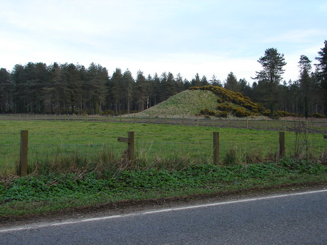
Droughduil Mound
Droughduil Mound (erroneously known as Droughdool Mote) is a Neolithic mound in juxtaposition with the site of an enclosure to the north.
1036:
655:"}},"text\/plain":{"en":{"P275":"Creative Commons Attribution-ShareAlike 2.0 Generic"}}}}": -->
723:"}},"text\/plain":{"en":{"P973":"https:\/\/www.geograph.org.uk\/photo\/746819"}}}}": -->
746:
678:
634:
304:
254:
781:
339:
1103:
This file contains additional information, probably added from the digital camera or scanner used to create or digitize it.
429:
589:
962:
935:
894:
867:
759:
730:
618:
582:
567:
554:
821:
789:
774:
662:
527:
486:
1025:
1020:
42:
385:
1106:
If the file has been modified from its original state, some details may not fully reflect the modified file.
428:– If you remix, transform, or build upon the material, you must distribute your contributions under the
346:
on the
Geograph website for the photographer's contact details. The copyright on this image is owned by
520:"}},"text\/plain":{"en":{"P3831":"photographer"}}}}": -->
611:"}},"text\/plain":{"en":{"P6216":"copyrighted"}}}}": -->
1053:
The following pages on the
English Knowledge use this file (pages on other projects are not listed):
928:"}},"text\/plain":{"en":{"P7787":"135 degree"}}}}": -->
860:"}},"text\/plain":{"en":{"P7787":"135 degree"}}}}": -->
91:
186:
574:
796:
766:
382:
170:
8:
326:
310:
260:
351:
78:
476:
1057:
213:
159:
149:
127:
945:
877:
831:
740:
672:
628:
537:
331:
343:
1062:
993:
Click on a date/time to view the file as it appeared at that time.
296:
246:
281:
54° 52′ 20″ N, 4° 53′ 15″ W
231:
54° 52′ 23″ N, 4° 53′ 21″ W
138:
66:
470:
Add a one-line explanation of what this file represents
1090:
1080:
1051:
1071:
991:
90:
Commons is a freely licensed media file repository.
679:
Creative
Commons Attribution-ShareAlike 2.0 Generic
653:
Creative
Commons Attribution-ShareAlike 2.0 Generic
56:(640 × 480 pixels, file size: 80 KB, MIME type:
116:Droughduil Mound - geograph.org.uk - 746819.jpg
52:Droughduil_Mound_-_geograph.org.uk_-_746819.jpg
439:https://creativecommons.org/licenses/by-sa/2.0
71:
510:https:\/\/www.geograph.org.uk\/profile\/21838
445:Creative Commons Attribution-Share Alike 2.0
363:
134:
113:
721:https:\/\/www.geograph.org.uk\/photo\/746819
155:
144:
14:
925:
857:
405:– to copy, distribute and transmit the work
1073:The following other wikis use this file:
575:https://www.geograph.org.uk/profile/21838
797:https://www.geograph.org.uk/photo/746819
128:http://orgs.man.ac.uk/research/dunragit/
303:View this and other nearby images on:
253:View this and other nearby images on:
193:
102:
350:and is licensed for reuse under the
271:
221:
984:
386:Attribution-Share Alike 2.0 Generic
374:
369:
354:Attribution-ShareAlike 2.0 license.
13:
1101:
475:
469:
360:
337:
120:
103:
49:
1127:
1108:
474:
1052:
868:coordinates of the point of view
850:coordinates of the point of view
460:
416:Under the following conditions:
381:This file is licensed under the
373:
368:
362:
330:
309:
295:
287:
259:
245:
237:
70:
31:
21:
457:
121:
46:No higher resolution available.
1068:
988:
747:file available on the internet
697:file available on the internet
456:
338:This image was taken from the
26:
1:
936:coordinates of depicted place
918:coordinates of depicted place
36:
1048:
782:Geograph Britain and Ireland
713:Geograph Britain and Ireland
583:object of statement has role
514:object of statement has role
482:Items portrayed in this file
322:
286:
236:
7:
1098:
1077:Usage on sco.wikipedia.org
951:54°52'19.81"N, 4°53'15.00"W
883:54°52'23.23"N, 4°53'20.76"W
10:
1132:
1087:Usage on www.wikidata.org
430:same or compatible license
110:
105:
985:
199:Chris Newman /
180:Chris Newman /
16:
760:geograph.org.uk image ID
701:geograph.org.uk image ID
459:
396:
77:This is a file from the
41:
1042:
1021:11:12, 19 February 2011
171:required by the license
137:
81:. Information from its
344:this photograph's page
315:54.872170; -4.887500
265:54.873120; -4.889100
214:Link to Openstreetmap
84:description page there
411:– to adapt the work
207:Openstreetmap entry
555:author name string
502:author name string
1119:
1118:
1069:Global file usage
1046:
927:
859:
663:copyright license
649:copyright license
468:
359:
358:
342:collection. See
320:
319:
270:
269:
219:
218:
174:
99:
98:
79:Wikimedia Commons
32:Global file usage
1123:
1109:
1033:
995:
973:
972:
967:
905:
904:
899:
799:
794:
790:described at URL
784:
779:
769:
764:
717:described at URL
619:copyright status
605:copyright status
592:
587:
577:
572:
562:
559:
466:
452:
449:
446:
443:
440:
432:as the original.
394:
383:Creative Commons
377:
376:
372:
371:
366:
365:
352:Creative Commons
340:Geograph project
334:
327:
316:
313:
299:
298:
292:
291:
290:
284:
283:
272:
266:
263:
249:
248:
242:
241:
240:
234:
233:
222:
201:Droughduil Mound
182:Droughduil Mound
168:
140:
125:
117:
111:
95:
74:
73:
67:
61:
59:
1131:
1130:
1126:
1125:
1124:
1122:
1121:
1120:
1097:
1067:
1058:Droughdool Mote
1054:
1047:
1039:
1031:
987:
986:
983:
982:
981:
980:
979:
978:
977:
976:
975:
974:
970:
968:
965:
956:
955:
954:
952:
942:
941:
940:
938:
915:
914:
913:
912:
911:
910:
909:
908:
907:
906:
902:
900:
897:
888:
887:
886:
884:
874:
873:
872:
870:
847:
846:
845:
844:
843:
842:
841:
840:
838:
828:
827:
826:
824:
809:
808:
807:
806:
805:
804:
803:
802:
801:
800:
795:
792:
786:
785:
780:
777:
771:
770:
765:
762:
753:
752:
751:
749:
737:
736:
735:
733:
690:
689:
688:
687:
686:
685:
684:
683:
681:
669:
668:
667:
665:
646:
645:
644:
643:
642:
641:
640:
639:
637:
625:
624:
623:
621:
602:
601:
600:
599:
598:
597:
596:
595:
594:
593:
588:
585:
579:
578:
573:
570:
564:
563:
560:
557:
548:
547:
546:
544:
534:
533:
532:
530:
495:
494:
493:
492:
491:
489:
473:
472:
471:
454:
453:
450:
447:
444:
441:
438:
437:
395:
392:
389:
378:
355:
325:
314:
288:
279:
278:
275:Object location
264:
238:
229:
228:
225:Camera location
220:
210:
196:
189:
177:
150:geograph.org.uk
130:
115:
108:
101:
100:
89:
88:
87:is shown below.
63:
57:
55:
48:
47:
12:
11:
5:
1129:
1117:
1116:
1113:
1100:
1096:
1095:
1094:
1093:
1085:
1084:
1083:
1070:
1066:
1065:
1060:
1050:
1045:
1044:
1041:
1037:
1034:
1028:
1023:
1018:
1014:
1013:
1010:
1007:
1004:
1001:
998:
990:
961:
960:
959:
958:
957:
953:
950:
948:
947:
946:
944:
943:
939:
934:
932:
931:
930:
929:
923:
919:
893:
892:
891:
890:
889:
885:
882:
880:
879:
878:
876:
875:
871:
866:
864:
863:
862:
861:
855:
851:
839:
836:
834:
833:
832:
830:
829:
825:
820:
818:
817:
816:
815:
813:
788:
787:
773:
772:
758:
757:
756:
755:
754:
750:
745:
743:
742:
741:
739:
738:
734:
731:source of file
729:
727:
726:
725:
724:
722:
718:
714:
710:
706:
702:
698:
694:
693:source of file
682:
677:
675:
674:
673:
671:
670:
666:
661:
659:
658:
657:
656:
654:
650:
638:
633:
631:
630:
629:
627:
626:
622:
617:
615:
614:
613:
612:
610:
606:
581:
580:
566:
565:
553:
552:
551:
550:
549:
545:
542:
540:
539:
538:
536:
535:
531:
526:
524:
523:
522:
521:
519:
515:
511:
507:
503:
499:
490:
485:
483:
480:
479:
478:
477:
465:
464:
461:
458:
436:
435:
434:
433:
423:
414:
413:
412:
406:
399:You are free:
390:
380:
379:
361:
357:
356:
335:
324:
321:
318:
317:
307:
301:
276:
268:
267:
257:
251:
226:
217:
216:
211:
208:
204:
203:
197:
194:
191:
190:
185:
178:
175:
163:
162:
157:
153:
152:
146:
142:
141:
136:
132:
131:
118:
109:
107:
104:
97:
96:
75:
65:
64:
45:
40:
39:
34:
29:
24:
19:
9:
6:
4:
3:
2:
1128:
1114:
1111:
1110:
1107:
1104:
1092:
1089:
1088:
1086:
1082:
1079:
1078:
1076:
1075:
1074:
1064:
1061:
1059:
1056:
1055:
1040:
1035:
1029:
1027:
1024:
1022:
1019:
1016:
1015:
1011:
1008:
1005:
1002:
999:
997:
996:
994:
964:
949:
937:
933:
896:
881:
869:
865:
837:31 March 2008
835:
823:
819:
798:
791:
783:
776:
768:
761:
748:
744:
732:
728:
680:
676:
664:
660:
636:
632:
620:
616:
591:
584:
576:
569:
556:
541:
529:
525:
488:
484:
481:
462:
455:
442:CC BY-SA 2.0
431:
427:
424:
421:
418:
417:
415:
410:
407:
404:
401:
400:
398:
397:
391:Attribution:
387:
384:
367:
353:
349:
345:
341:
336:
333:
329:
328:
312:
308:
306:
305:OpenStreetMap
302:
300:
282:
277:
274:
273:
262:
258:
256:
255:OpenStreetMap
252:
250:
232:
227:
224:
223:
215:
212:
206:
205:
202:
198:
192:
188:
184: /
183:
179:
172:
167:
165:
164:
161:
158:
154:
151:
147:
143:
139:31 March 2008
133:
129:
124:
119:
112:
93:
86:
85:
80:
76:
69:
68:
62:
53:
44:
38:
35:
33:
30:
28:
25:
23:
20:
18:
15:
1105:
1102:
1072:
992:
989:File history
590:photographer
561:Chris Newman
518:photographer
425:
419:
408:
402:
393:Chris Newman
348:Chris Newman
347:
285:
235:
200:
187:CC BY-SA 2.0
181:
160:Chris Newman
122:
92:You can help
82:
50:
22:File history
1038:GeographBot
635:copyrighted
609:copyrighted
426:share alike
420:attribution
166:Attribution
114:Description
1112:_error
1049:File usage
1030:640 × 480
1006:Dimensions
543:some value
58:image/jpeg
27:File usage
1091:Q56666533
1003:Thumbnail
1000:Date/Time
822:inception
812:inception
323:Licensing
209:InfoField
195:InfoField
176:InfoField
123:English:
1099:Metadata
1081:Dunragit
1063:Dunragit
775:operator
709:operator
463:Captions
409:to remix
403:to share
388:license.
37:Metadata
1032:(80 KB)
1017:current
1012:Comment
963:heading
922:heading
895:heading
854:heading
528:creator
498:creator
487:depicts
467:English
106:Summary
54:
971:degree
926:degree
903:degree
858:degree
767:746819
705:746819
293:
243:
156:Author
145:Source
148:From
1009:User
969:135
901:135
451:true
448:true
135:Date
17:File
568:URL
506:URL
966::
898::
793::
778::
763::
586::
571::
558::
1115:0
173:)
169:(
94:.
60:)
Text is available under the Creative Commons Attribution-ShareAlike License. Additional terms may apply.
_heading:135.00&language=en)
_heading:135.00&language=en)
