732:"}},"text\/plain":{"en":{"":"coordinates of depicted place"}}},"{\"value\":{\"latitude\":51.7703685,\"longitude\":10.7271247,\"altitude\":null,\"precision\":1.0e-5,\"globe\":\"http:\\\/\\\/www.wikidata.org\\\/entity\\\/Q2\"},\"type\":\"globecoordinate\"}":{"text\/html":{"en":{"P9149":"51\u00b046'13.33"N, 10\u00b043'37.63"E"}},"text\/plain":{"en":{"P9149":"51\u00b046'13.33\"N, 10\u00b043'37.63\"E"}}},"{\"value\":{\"entity-type\":\"property\",\"numeric-id\":248,\"id\":\"P248\"},\"type\":\"wikibase-entityid\"}":{"text\/html":{"en":{"":"
694:"}},"text\/plain":{"en":{"":"coordinates of the point of view"}}},"{\"value\":{\"latitude\":51.77022181,\"longitude\":10.72687265,\"altitude\":null,\"precision\":1.0e-8,\"globe\":\"http:\\\/\\\/www.wikidata.org\\\/entity\\\/Q2\"},\"type\":\"globecoordinate\"}":{"text\/html":{"en":{"P1259":"51\u00b046'12.79852"N, 10\u00b043'36.74154"E"}},"text\/plain":{"en":{"P1259":"51\u00b046'12.79852\"N, 10\u00b043'36.74154\"E"}}}}": -->
220:
656:"}},"text\/plain":{"en":{"":"inception"}}},"{\"value\":{\"time\":\"+2003-06-25T00:00:00Z\",\"timezone\":0,\"before\":0,\"after\":0,\"precision\":11,\"calendarmodel\":\"http:\\\/\\\/www.wikidata.org\\\/entity\\\/Q1985727\"},\"type\":\"time\"}":{"text\/html":{"en":{"P571":"25 June 2003"}},"text\/plain":{"en":{"P571":"25 June 2003"}}}}": -->
354:
269:
227:
307:
283:
241:
360:
91:
551:"}},"text\/plain":{"en":{"P275":"GNU Free Documentation License, version 1.2 or later"}}},"{\"value\":{\"entity-type\":\"item\",\"numeric-id\":14946043,\"id\":\"Q14946043\"},\"type\":\"wikibase-entityid\"}":{"text\/html":{"en":{"P275":"
365:
728:
736:"}},"text\/plain":{"en":{"":"stated in"}}},"{\"value\":{\"entity-type\":\"item\",\"numeric-id\":936,\"id\":\"Q936\"},\"type\":\"wikibase-entityid\"}":{"text\/html":{"en":{"P248":"
690:
859:{{deutsch}} HSB-Bahnhof Drei Annen-Hohne am 23. März 2003. {{english}} HSB station in Drei Annen-Hohne on 23. March 2003. '''Source:''' Photo taken by Steffen Mokosch, originally uploaded to
413:– You must give appropriate credit, provide a link to the license, and indicate if changes were made. You may do so in any reasonable manner, but not in any way that suggests the licensor endorses you or your use.
266:
224:
212:
260:
613:
552:
548:
504:
729:
691:
609:
500:
737:
733:
653:
544:
324:
555:"}},"text\/plain":{"en":{"P275":"Creative Commons Attribution-ShareAlike 3.0 Unported"}}}}": -->
322:; with no Invariant Sections, no Front-Cover Texts, and no Back-Cover Texts. A copy of the license is included in the section entitled
57:
53:
47:
102:
219:
70:
639:
595:
578:
530:
276:
234:
943:
This file contains additional information, probably added from the digital camera or scanner used to create or digitize it.
860:
420:
747:
701:
623:
514:
616:"}},"text\/plain":{"en":{"P7482":"original creation by uploader"}}}}": -->
314:
785:
778:
663:
562:
489:
374:
946:
If the file has been modified from its original state, some details may not fully reflect the modified file.
319:
419:– If you remix, transform, or build upon the material, you must distribute your contributions under the
740:"}},"text\/plain":{"en":{"P248":"OpenStreetMap"}}}}": -->
507:"}},"text\/plain":{"en":{"P6216":"copyrighted"}}}}": -->
873:
The following pages on the
English Knowledge use this file (pages on other projects are not listed):
877:
110:
841:
836:
61:
42:
434:
312:
Permission is granted to copy, distribute and/or modify this document under the terms of the
371:
8:
282:
240:
97:
479:
193:
852:
910:
757:
711:
673:
633:
589:
572:
524:
920:
301:
809:
Click on a date/time to view the file as it appeared at that time.
268:
226:
900:
261:
51° 46′ 12.8″ N, 10° 43′ 36.74″ E
433:
This licensing tag was added to this file as part of the GFDL
213:
51° 46′ 13.3″ N, 10° 43′ 37.6″ E
895:
162:
85:
473:
Add a one-line explanation of what this file represents
871:
930:
886:
807:
596:
Creative
Commons Attribution-ShareAlike 3.0 Unported
579:
553:
Creative
Commons Attribution-ShareAlike 3.0 Unported
549:
318:, Version 1.2 or any later version published by the
109:
Commons is a freely licensed media file repository.
75:(867 × 586 pixels, file size: 78 KB, MIME type:
440:http://creativecommons.org/licenses/by-sa/3.0/
90:
353:
194:
158:
132:
446:Creative Commons Attribution-Share Alike 3.0
178:
168:
14:
396:– to copy, distribute and transmit the work
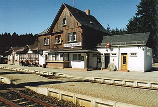
218:
888:The following other wikis use this file:
275:View this and other nearby images on:
233:View this and other nearby images on:
121:
861:de:Bild:Drei Annen Hohne Bahnhof.JPG
375:Attribution-Share Alike 3.0 Unported
348:
330:http://www.gnu.org/copyleft/fdl.html
251:
203:
800:
364:
359:
13:
941:
717:51°46'12.79852"N, 10°43'36.74154"E
478:
472:
147:
139:
122:
68:
967:
948:
477:
872:
702:coordinates of the point of view
692:coordinates of the point of view
463:
407:Under the following conditions:
370:This file is licensed under the
363:
358:
352:
306:
305:
281:
267:
239:
225:
153:HSB station in Drei-Annen-Hohne.
89:
31:
21:
460:
148:
883:
804:
459:
336:GNU Free Documentation License
325:GNU Free Documentation License
315:GNU Free Documentation License
140:
26:
1:
748:coordinates of depicted place
730:coordinates of depicted place
640:original creation by uploader
614:original creation by uploader
145:HSB-Bahnhof Drei-Annen-Hohne.
36:
911:Stazione di Drei Annen Hohne
868:
763:51°46'13.33"N, 10°43'37.63"E
485:Items portrayed in this file
297:
135:Drei Annen Hohne Bahnhof.JPG
7:
938:
892:Usage on de.wikivoyage.org
10:
972:
927:Usage on www.wikidata.org
917:Usage on nl.wikipedia.org
907:Usage on it.wikipedia.org
421:same or compatible license
129:
124:
801:
379:
351:
172:
16:
921:Station Drei Annen Hohne
878:Drei Annen Hohne station
462:
320:Free Software Foundation
96:This is a file from the
41:
858:
837:21:07, 12 November 2005
161:
100:. Information from its
287:51.770222; 10.726873
245:51.770368; 10.727125
103:description page there
46:Size of this preview:
863:by [[:de:Benutzer:S
402:– to adapt the work
52:Other resolutions:
959:
958:
901:Harzer Hexenstieg
884:Global file usage
866:
563:copyright license
545:copyright license
471:
457:
456:
347:
346:
292:
291:
250:
249:
201:
200:
118:
117:
98:Wikimedia Commons
32:Global file usage
963:
949:
849:
811:
788:
783:
515:copyright status
501:copyright status
469:
453:
450:
447:
444:
441:
438:
435:licensing update
423:as the original.
372:Creative Commons
367:
366:
362:
361:
356:
355:
349:
343:
340:
337:
334:
331:
309:
308:
302:
288:
285:
271:
270:
264:
263:
252:
246:
243:
229:
228:
222:
216:
215:
204:
196:
174:
164:
152:
144:
136:
130:
114:
93:
92:
86:
80:
78:
65:
62:867 × 586 pixels
58:640 × 433 pixels
54:320 × 216 pixels
48:800 × 541 pixels
971:
970:
966:
965:
964:
962:
961:
960:
937:
882:
874:
867:
855:
847:
803:
802:
799:
798:
797:
796:
795:
794:
793:
792:
791:
790:
789:
784:
781:
768:
767:
766:
764:
754:
753:
752:
750:
727:
726:
725:
724:
723:
722:
721:
720:
718:
708:
707:
706:
704:
689:
688:
687:
686:
685:
684:
683:
682:
680:
670:
669:
668:
666:
651:
650:
649:
648:
647:
646:
645:
644:
642:
630:
629:
628:
626:
607:
606:
605:
604:
603:
602:
601:
600:
598:
587:
586:
585:
584:
583:
581:
569:
568:
567:
565:
542:
541:
540:
539:
538:
537:
536:
535:
533:
521:
520:
519:
517:
498:
497:
496:
495:
494:
492:
476:
475:
474:
451:
448:
445:
442:
439:
432:
341:
338:
335:
332:
329:
300:
286:
259:
258:
255:Camera location
244:
211:
210:
207:Object location
202:
195:Node 3326686677
190:
182:Steffen Mokosch
154:
146:
134:
127:
120:
119:
108:
107:
106:is shown below.
82:
76:
74:
67:
66:
51:
12:
11:
5:
969:
957:
956:
953:
940:
936:
935:
934:
933:
925:
924:
923:
915:
914:
913:
905:
904:
903:
898:
885:
881:
880:
870:
865:
864:
857:
853:
850:
844:
839:
834:
830:
829:
826:
823:
820:
817:
814:
806:
777:
776:
775:
774:
773:
770:
769:
765:
762:
760:
759:
758:
756:
755:
751:
746:
744:
743:
742:
741:
739:
735:
731:
719:
716:
714:
713:
712:
710:
709:
705:
700:
698:
697:
696:
695:
693:
681:
678:
676:
675:
674:
672:
671:
667:
662:
660:
659:
658:
657:
655:
643:
638:
636:
635:
634:
632:
631:
627:
624:source of file
622:
620:
619:
618:
617:
615:
611:
610:source of file
599:
594:
592:
591:
590:
588:
582:
577:
575:
574:
573:
571:
570:
566:
561:
559:
558:
557:
556:
554:
550:
546:
534:
529:
527:
526:
525:
523:
522:
518:
513:
511:
510:
509:
508:
506:
502:
493:
488:
486:
483:
482:
481:
480:
468:
467:
464:
461:
455:
454:
429:
428:
427:
426:
425:
424:
414:
405:
404:
403:
397:
390:You are free:
385:
384:
381:
380:
378:
368:
345:
344:
310:
299:
296:
290:
289:
279:
273:
256:
248:
247:
237:
231:
208:
199:
198:
191:
188:
184:
183:
180:
176:
175:
170:
166:
165:
160:
156:
155:
137:
128:
126:
123:
116:
115:
94:
84:
83:
45:
40:
39:
34:
29:
24:
19:
9:
6:
4:
3:
2:
968:
954:
951:
950:
947:
944:
932:
929:
928:
926:
922:
919:
918:
916:
912:
909:
908:
906:
902:
899:
897:
894:
893:
891:
890:
889:
879:
876:
875:
862:
856:
851:
845:
843:
840:
838:
835:
832:
831:
827:
824:
821:
818:
815:
813:
812:
810:
787:
786:OpenStreetMap
780:
771:
761:
749:
745:
738:OpenStreetMap
715:
703:
699:
677:
665:
661:
641:
637:
625:
621:
597:
593:
580:
576:
564:
560:
532:
528:
516:
512:
491:
487:
484:
465:
458:
436:
431:
430:
422:
418:
415:
412:
409:
408:
406:
401:
398:
395:
392:
391:
389:
388:
387:
386:
383:
382:
376:
373:
369:
357:
350:
327:
326:
321:
317:
316:
311:
304:
303:
295:
294:
284:
280:
278:
277:OpenStreetMap
274:
272:
262:
257:
254:
253:
242:
238:
236:
235:OpenStreetMap
232:
230:
221:
214:
209:
206:
205:
197:
192:
187:OpenStreetMap
186:
185:
181:
177:
171:
167:
157:
151:
143:
138:
131:
112:
105:
104:
99:
95:
88:
87:
81:
72:
71:Original file
63:
59:
55:
49:
44:
38:
35:
33:
30:
28:
25:
23:
20:
18:
15:
945:
942:
887:
808:
805:File history
679:25 June 2003
443:CC BY-SA 3.0
416:
410:
399:
393:
323:
313:
293:
163:25 June 2003
149:
141:
111:You can help
101:
69:
22:File history
896:Wernigerode
531:copyrighted
505:copyrighted
417:share alike
411:attribution
133:Description
952:_error
869:File usage
846:867 × 586
822:Dimensions
77:image/jpeg
27:File usage
819:Thumbnail
816:Date/Time
779:stated in
772:Reference
734:stated in
664:inception
654:inception
377:license.
298:Licensing
189:InfoField
150:English:
142:Deutsch:
939:Metadata
854:Dabbelju
466:Captions
400:to remix
394:to share
173:Own work
37:Metadata
931:Q800685
848:(78 KB)
833:current
828:Comment
490:depicts
470:English
125:Summary
73:
265:
223:
217:
179:Author
169:Source
825:User
452:true
449:true
342:true
339:true
333:GFDL
159:Date
17:File
782::
60:|
56:|
50:.
955:0
437:.
328:.
113:.
79:)
64:.
Text is available under the Creative Commons Attribution-ShareAlike License. Additional terms may apply.
