831:"}},"text\/plain":{"en":{"":"coordinates of the point of view"}}},"{\"value\":{\"latitude\":57.52678,\"longitude\":-2.9884,\"altitude\":null,\"precision\":1.0e-5,\"globe\":\"http:\\\/\\\/www.wikidata.org\\\/entity\\\/Q2\"},\"type\":\"globecoordinate\"}":{"text\/html":{"en":{"P1259":"57\u00b031'36.41"N, 2\u00b059'18.24"W"}},"text\/plain":{"en":{"P1259":"57\u00b031'36.41\"N, 2\u00b059'18.24\"W"}}},"{\"value\":{\"entity-type\":\"property\",\"numeric-id\":7787,\"id\":\"P7787\"},\"type\":\"wikibase-entityid\"}":{"text\/html":{"en":{"":"
899:"}},"text\/plain":{"en":{"":"coordinates of depicted place"}}},"{\"value\":{\"latitude\":57.52736,\"longitude\":-2.9838,\"altitude\":null,\"precision\":1.0e-5,\"globe\":\"http:\\\/\\\/www.wikidata.org\\\/entity\\\/Q2\"},\"type\":\"globecoordinate\"}":{"text\/html":{"en":{"P9149":"57\u00b031'38.50"N, 2\u00b059'1.68"W"}},"text\/plain":{"en":{"P9149":"57\u00b031'38.50\"N, 2\u00b059'1.68\"W"}}},"{\"value\":{\"entity-type\":\"property\",\"numeric-id\":7787,\"id\":\"P7787\"},\"type\":\"wikibase-entityid\"}":{"text\/html":{"en":{"":"
1140:"}},"text\/plain":{"en":{"":"checksum"}}},"{\"value\":\"7ce6f28e3a9d425798d78d5cac74a27131484c4b\",\"type\":\"string\"}":{"text\/html":{"en":{"P4092":"7ce6f28e3a9d425798d78d5cac74a27131484c4b"}},"text\/plain":{"en":{"P4092":"7ce6f28e3a9d425798d78d5cac74a27131484c4b"}}},"{\"value\":{\"entity-type\":\"property\",\"numeric-id\":459,\"id\":\"P459\"},\"type\":\"wikibase-entityid\"}":{"text\/html":{"en":{"":"
491:"}},"text\/plain":{"en":{"":"author name string"}}},"{\"value\":\"Anne Burgess\",\"type\":\"string\"}":{"text\/html":{"en":{"P2093":"Anne Burgess"}},"text\/plain":{"en":{"P2093":"Anne Burgess"}}},"{\"value\":{\"entity-type\":\"property\",\"numeric-id\":3831,\"id\":\"P3831\"},\"type\":\"wikibase-entityid\"}":{"text\/html":{"en":{"":"
793:"}},"text\/plain":{"en":{"":"inception"}}},"{\"value\":{\"time\":\"+2007-06-27T00:00:00Z\",\"timezone\":0,\"before\":0,\"after\":0,\"precision\":11,\"calendarmodel\":\"http:\\\/\\\/www.wikidata.org\\\/entity\\\/Q1985727\"},\"type\":\"time\"}":{"text\/html":{"en":{"P571":"27 June 2007"}},"text\/plain":{"en":{"P571":"27 June 2007"}}}}": -->
670:
276:
226:
1136:
218:
290:
240:
311:
349:
354:
67:
694:"}},"text\/plain":{"en":{"P973":"https:\/\/www.geograph.org.uk\/photo\/478509"}}},"{\"value\":{\"entity-type\":\"property\",\"numeric-id\":7384,\"id\":\"P7384\"},\"type\":\"wikibase-entityid\"}":{"text\/html":{"en":{"":"
487:"}},"text\/plain":{"en":{"P2699":"https:\/\/www.geograph.org.uk\/profile\/139"}}},"{\"value\":{\"entity-type\":\"property\",\"numeric-id\":2093,\"id\":\"P2093\"},\"type\":\"wikibase-entityid\"}":{"text\/html":{"en":{"":"
678:"}},"text\/plain":{"en":{"P7482":"file available on the internet"}}},"{\"value\":{\"entity-type\":\"property\",\"numeric-id\":137,\"id\":\"P137\"},\"type\":\"wikibase-entityid\"}":{"text\/html":{"en":{"":"
495:"}},"text\/plain":{"en":{"":"object of statement has role"}}},"{\"value\":{\"entity-type\":\"item\",\"numeric-id\":33231,\"id\":\"Q33231\"},\"type\":\"wikibase-entityid\"}":{"text\/html":{"en":{"P3831":"
686:"}},"text\/plain":{"en":{"P137":"Geograph Britain and Ireland"}}},"{\"value\":{\"entity-type\":\"property\",\"numeric-id\":973,\"id\":\"P973\"},\"type\":\"wikibase-entityid\"}":{"text\/html":{"en":{"":"
1144:"}},"text\/plain":{"en":{"":"determination method"}}},"{\"value\":{\"entity-type\":\"item\",\"numeric-id\":13414952,\"id\":\"Q13414952\"},\"type\":\"wikibase-entityid\"}":{"text\/html":{"en":{"P459":"
1102:"}},"text\/plain":{"en":{"":"media type"}}},"{\"value\":\"image\\\/jpeg\",\"type\":\"string\"}":{"text\/html":{"en":{"P1163":"image\/jpeg"}},"text\/plain":{"en":{"P1163":"image\/jpeg"}}}}": -->
630:"}},"text\/plain":{"en":{"":"copyright license"}}},"{\"value\":{\"entity-type\":\"item\",\"numeric-id\":19068220,\"id\":\"Q19068220\"},\"type\":\"wikibase-entityid\"}":{"text\/html":{"en":{"P275":"
586:"}},"text\/plain":{"en":{"":"copyright status"}}},"{\"value\":{\"entity-type\":\"item\",\"numeric-id\":50423863,\"id\":\"Q50423863\"},\"type\":\"wikibase-entityid\"}":{"text\/html":{"en":{"P6216":"
674:"}},"text\/plain":{"en":{"":"source of file"}}},"{\"value\":{\"entity-type\":\"item\",\"numeric-id\":74228490,\"id\":\"Q74228490\"},\"type\":\"wikibase-entityid\"}":{"text\/html":{"en":{"P7482":"
967:"}},"text\/plain":{"en":{"":"data size"}}},"{\"value\":{\"amount\":\"+177965\",\"unit\":\"http:\\\/\\\/www.wikidata.org\\\/entity\\\/Q8799\"},\"type\":\"quantity\"}":{"text\/html":{"en":{"P3575":"177,965
1012:"}},"text\/plain":{"en":{"":"height"}}},"{\"value\":{\"amount\":\"+382\",\"unit\":\"http:\\\/\\\/www.wikidata.org\\\/entity\\\/Q355198\"},\"type\":\"quantity\"}":{"text\/html":{"en":{"P2048":"382
682:"}},"text\/plain":{"en":{"":"operator"}}},"{\"value\":{\"entity-type\":\"item\",\"numeric-id\":1503119,\"id\":\"Q1503119\"},\"type\":\"wikibase-entityid\"}":{"text\/html":{"en":{"P137":"
1057:"}},"text\/plain":{"en":{"":"width"}}},"{\"value\":{\"amount\":\"+640\",\"unit\":\"http:\\\/\\\/www.wikidata.org\\\/entity\\\/Q355198\"},\"type\":\"quantity\"}":{"text\/html":{"en":{"P2049":"640
903:"}},"text\/plain":{"en":{"":"heading"}}},"{\"value\":{\"amount\":\"+90\",\"unit\":\"http:\\\/\\\/www.wikidata.org\\\/entity\\\/Q28390\"},\"type\":\"quantity\"}":{"text\/html":{"en":{"P7787":"90
835:"}},"text\/plain":{"en":{"":"heading"}}},"{\"value\":{\"amount\":\"+90\",\"unit\":\"http:\\\/\\\/www.wikidata.org\\\/entity\\\/Q28390\"},\"type\":\"quantity\"}":{"text\/html":{"en":{"P7787":"90
479:"}},"text\/plain":{"en":{"":"creator"}}},"{\"value\":{\"entity-type\":\"property\",\"numeric-id\":2699,\"id\":\"P2699\"},\"type\":\"wikibase-entityid\"}":{"text\/html":{"en":{"":"
1098:
690:"}},"text\/plain":{"en":{"":"described at URL"}}},"{\"value\":\"https:\\\/\\\/www.geograph.org.uk\\\/photo\\\/478509\",\"type\":\"string\"}":{"text\/html":{"en":{"P973":"
483:"}},"text\/plain":{"en":{"":"URL"}}},"{\"value\":\"https:\\\/\\\/www.geograph.org.uk\\\/profile\\\/139\",\"type\":\"string\"}":{"text\/html":{"en":{"P2699":"
698:"}},"text\/plain":{"en":{"":"geograph.org.uk image ID"}}},"{\"value\":\"478509\",\"type\":\"string\"}":{"text\/html":{"en":{"P7384":"
259:
38:
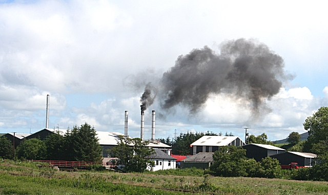
1262:== {{int:filedesc}} == {{Information |description={{en|1=Douglasbrae Black smoke belches from the incinerators at the Douglasbrae Knackery. This business deals with the disposal of animal carcasses from all over the north-east of Scotland.}} |date=2007-06
209:
401:– You must give appropriate credit, provide a link to the license, and indicate if changes were made. You may do so in any reasonable manner, but not in any way that suggests the licensor endorses you or your use.
273:
223:
121:
Douglasbrae Black smoke belches from the incinerators at the
Douglasbrae Knackery. This business deals with the disposal of animal carcasses from all over the north-east of Scotland.
1145:
699:
675:
631:
587:
683:
496:
1137:
1099:
1054:
1009:
964:
900:
896:
832:
828:
695:
671:
583:
492:
488:
480:
1141:
790:
691:
687:
679:
627:
476:
484:
78:
46:
1255:
634:"}},"text\/plain":{"en":{"P275":"Creative Commons Attribution-ShareAlike 2.0 Generic"}}}}": -->
1189:
725:
657:
613:
283:
233:
745:
318:
1287:
This file contains additional information, probably added from the digital camera or scanner used to create or digitize it.
408:
568:
1155:
1109:
1068:
1023:
978:
941:
914:
873:
846:
768:
709:
597:
561:
548:
533:
1182:
800:
753:
738:
641:
506:
465:
364:
1290:
If the file has been modified from its original state, some details may not fully reflect the modified file.
1244:
1239:
37:
407:– If you remix, transform, or build upon the material, you must distribute your contributions under the
325:
on the
Geograph website for the photographer's contact details. The copyright on this image is owned by
971:"}},"text\/plain":{"en":{"P3575":"177,965 byte"}}}}": -->
499:"}},"text\/plain":{"en":{"P3831":"photographer"}}}}": -->
590:"}},"text\/plain":{"en":{"P6216":"copyrighted"}}}}": -->
1272:
The following pages on the
English Knowledge use this file (pages on other projects are not listed):
1061:"}},"text\/plain":{"en":{"P2049":"640 pixel"}}}}": -->
1016:"}},"text\/plain":{"en":{"P2048":"382 pixel"}}}}": -->
907:"}},"text\/plain":{"en":{"P7787":"90 degree"}}}}": -->
839:"}},"text\/plain":{"en":{"P7787":"90 degree"}}}}": -->
86:
702:"}},"text\/plain":{"en":{"P7384":"478509"}}}}": -->
178:
1148:"}},"text\/plain":{"en":{"P459":"SHA-1"}}}}": -->
775:
760:
361:
162:
540:
8:
305:
289:
239:
330:
73:
455:
141:
1165:
1119:
1078:
1033:
988:
924:
856:
810:
719:
651:
607:
516:
151:
310:
322:
1212:
Click on a date/time to view the file as it appeared at that time.
1276:
275:
225:
260:
57° 31′ 38″ N, 2° 59′ 02″ W
210:
57° 31′ 36″ N, 2° 59′ 18″ W
130:
61:
449:
Add a one-line explanation of what this file represents
1270:
1210:
85:
Commons is a freely licensed media file repository.
658:
Creative
Commons Attribution-ShareAlike 2.0 Generic
632:
Creative
Commons Attribution-ShareAlike 2.0 Generic
51:(640 × 382 pixels, file size: 174 KB, MIME type:
418:https://creativecommons.org/licenses/by-sa/2.0
66:
424:Creative Commons Attribution-Share Alike 2.0
342:
126:
108:
692:https:\/\/www.geograph.org.uk\/photo\/478509
147:
136:
14:
1058:
1013:
968:
904:
836:
485:https:\/\/www.geograph.org.uk\/profile\/139
384:– to copy, distribute and transmit the work
111:Douglasbrae - geograph.org.uk - 478509.jpg
47:Douglasbrae_-_geograph.org.uk_-_478509.jpg
1171:7ce6f28e3a9d425798d78d5cac74a27131484c4b
761:https://www.geograph.org.uk/photo/478509
541:https://www.geograph.org.uk/profile/139
282:View this and other nearby images on:
232:View this and other nearby images on:
185:
97:
329:and is licensed for reuse under the
250:
200:
1203:
365:Attribution-Share Alike 2.0 Generic
353:
348:
333:Attribution-ShareAlike 2.0 license.
13:
1285:
454:
448:
339:
316:
115:
98:
44:
1311:
1292:
453:
1271:
847:coordinates of the point of view
829:coordinates of the point of view
439:
395:Under the following conditions:
360:This file is licensed under the
352:
347:
341:
309:
288:
274:
266:
238:
224:
216:
65:
21:
436:
116:
41:No higher resolution available.
1207:
726:file available on the internet
676:file available on the internet
435:
317:This image was taken from the
26:
1:
915:coordinates of depicted place
897:coordinates of depicted place
31:
1267:
746:Geograph Britain and Ireland
684:Geograph Britain and Ireland
562:object of statement has role
493:object of statement has role
461:Items portrayed in this file
301:
7:
1282:
862:57°31'36.41"N, 2°59'18.24"W
265:
215:
10:
1316:
930:57°31'38.50"N, 2°59'1.68"W
409:same or compatible license
105:
100:
1204:
191:Anne Burgess /
172:Anne Burgess /
16:
769:geograph.org.uk image ID
696:geograph.org.uk image ID
438:
375:
72:This is a file from the
36:
1261:
163:required by the license
129:
76:. Information from its
1240:22:01, 4 February 2011
323:this photograph's page
294:57.527360; -2.983800
244:57.526780; -2.988400
79:description page there
1183:determination method
1142:determination method
390:– to adapt the work
549:author name string
489:author name string
1303:
1302:
1265:
1060:
1015:
970:
906:
838:
642:copyright license
628:copyright license
447:
338:
337:
321:collection. See
299:
298:
249:
248:
198:
197:
166:
94:
93:
74:Wikimedia Commons
1307:
1293:
1252:
1214:
1192:
1187:
1087:
1042:
997:
952:
951:
946:
884:
883:
878:
778:
773:
763:
758:
754:described at URL
748:
743:
688:described at URL
598:copyright status
584:copyright status
571:
566:
556:
553:
543:
538:
445:
431:
428:
425:
422:
419:
411:as the original.
373:
362:Creative Commons
356:
355:
351:
350:
345:
344:
331:Creative Commons
319:Geograph project
313:
306:
295:
292:
278:
277:
271:
270:
269:
263:
262:
251:
245:
242:
228:
227:
221:
220:
219:
213:
212:
201:
160:
132:
120:
112:
106:
90:
69:
68:
62:
56:
54:
1315:
1314:
1310:
1309:
1308:
1306:
1305:
1304:
1281:
1273:
1266:
1258:
1250:
1206:
1205:
1202:
1201:
1200:
1199:
1198:
1197:
1196:
1195:
1194:
1193:
1188:
1185:
1176:
1175:
1174:
1172:
1162:
1161:
1160:
1158:
1135:
1134:
1133:
1132:
1131:
1130:
1129:
1128:
1126:
1116:
1115:
1114:
1112:
1097:
1096:
1095:
1094:
1093:
1092:
1091:
1090:
1088:
1085:
1075:
1074:
1073:
1071:
1052:
1051:
1050:
1049:
1048:
1047:
1046:
1045:
1043:
1040:
1030:
1029:
1028:
1026:
1007:
1006:
1005:
1004:
1003:
1002:
1001:
1000:
998:
995:
985:
984:
983:
981:
962:
961:
960:
959:
958:
957:
956:
955:
954:
953:
949:
947:
944:
935:
934:
933:
931:
921:
920:
919:
917:
894:
893:
892:
891:
890:
889:
888:
887:
886:
885:
881:
879:
876:
867:
866:
865:
863:
853:
852:
851:
849:
826:
825:
824:
823:
822:
821:
820:
819:
817:
807:
806:
805:
803:
788:
787:
786:
785:
784:
783:
782:
781:
780:
779:
774:
771:
765:
764:
759:
756:
750:
749:
744:
741:
732:
731:
730:
728:
716:
715:
714:
712:
669:
668:
667:
666:
665:
664:
663:
662:
660:
648:
647:
646:
644:
625:
624:
623:
622:
621:
620:
619:
618:
616:
604:
603:
602:
600:
581:
580:
579:
578:
577:
576:
575:
574:
573:
572:
567:
564:
558:
557:
554:
551:
545:
544:
539:
536:
527:
526:
525:
523:
513:
512:
511:
509:
474:
473:
472:
471:
470:
468:
452:
451:
450:
433:
432:
429:
426:
423:
420:
417:
416:
374:
371:
368:
357:
334:
304:
293:
267:
258:
257:
254:Object location
243:
217:
208:
207:
204:Camera location
199:
188:
181:
169:
142:geograph.org.uk
122:
110:
103:
96:
95:
84:
83:
82:is shown below.
58:
52:
50:
43:
42:
12:
11:
5:
1313:
1301:
1300:
1297:
1284:
1280:
1279:
1269:
1264:
1263:
1260:
1256:
1253:
1247:
1242:
1237:
1233:
1232:
1229:
1226:
1223:
1220:
1217:
1209:
1181:
1180:
1179:
1178:
1177:
1173:
1170:
1168:
1167:
1166:
1164:
1163:
1159:
1154:
1152:
1151:
1150:
1149:
1147:
1143:
1139:
1127:
1124:
1122:
1121:
1120:
1118:
1117:
1113:
1108:
1106:
1105:
1104:
1103:
1101:
1089:
1083:
1081:
1080:
1079:
1077:
1076:
1072:
1067:
1065:
1064:
1063:
1062:
1056:
1044:
1038:
1036:
1035:
1034:
1032:
1031:
1027:
1022:
1020:
1019:
1018:
1017:
1011:
999:
993:
991:
990:
989:
987:
986:
982:
977:
975:
974:
973:
972:
966:
940:
939:
938:
937:
936:
932:
929:
927:
926:
925:
923:
922:
918:
913:
911:
910:
909:
908:
902:
898:
872:
871:
870:
869:
868:
864:
861:
859:
858:
857:
855:
854:
850:
845:
843:
842:
841:
840:
834:
830:
818:
815:
813:
812:
811:
809:
808:
804:
799:
797:
796:
795:
794:
792:
767:
766:
752:
751:
737:
736:
735:
734:
733:
729:
724:
722:
721:
720:
718:
717:
713:
710:source of file
708:
706:
705:
704:
703:
701:
697:
693:
689:
685:
681:
677:
673:
672:source of file
661:
656:
654:
653:
652:
650:
649:
645:
640:
638:
637:
636:
635:
633:
629:
617:
612:
610:
609:
608:
606:
605:
601:
596:
594:
593:
592:
591:
589:
585:
560:
559:
547:
546:
532:
531:
530:
529:
528:
524:
521:
519:
518:
517:
515:
514:
510:
505:
503:
502:
501:
500:
498:
494:
490:
486:
482:
478:
469:
464:
462:
459:
458:
457:
456:
444:
443:
440:
437:
415:
414:
413:
412:
402:
393:
392:
391:
385:
378:You are free:
369:
359:
358:
340:
336:
335:
314:
303:
300:
297:
296:
286:
280:
255:
247:
246:
236:
230:
205:
196:
195:
189:
186:
183:
182:
177:
170:
167:
155:
154:
149:
145:
144:
138:
134:
133:
128:
124:
123:
113:
104:
102:
99:
92:
91:
70:
60:
59:
40:
35:
34:
29:
24:
19:
9:
6:
4:
3:
2:
1312:
1298:
1295:
1294:
1291:
1288:
1278:
1275:
1274:
1259:
1254:
1248:
1246:
1243:
1241:
1238:
1235:
1234:
1230:
1227:
1224:
1221:
1218:
1216:
1215:
1213:
1191:
1184:
1169:
1157:
1153:
1123:
1111:
1107:
1082:
1070:
1066:
1037:
1025:
1021:
992:
980:
976:
943:
928:
916:
912:
875:
860:
848:
844:
814:
802:
798:
777:
770:
762:
755:
747:
740:
727:
723:
711:
707:
659:
655:
643:
639:
615:
611:
599:
595:
570:
563:
550:
542:
535:
520:
508:
504:
467:
463:
460:
441:
434:
421:CC BY-SA 2.0
410:
406:
403:
400:
397:
396:
394:
389:
386:
383:
380:
379:
377:
376:
370:Attribution:
366:
363:
346:
332:
328:
324:
320:
315:
312:
308:
307:
291:
287:
285:
284:OpenStreetMap
281:
279:
261:
256:
253:
252:
241:
237:
235:
234:OpenStreetMap
231:
229:
211:
206:
203:
202:
194:
190:
184:
180:
176: /
175:
171:
164:
159:
157:
156:
153:
150:
146:
143:
139:
135:
125:
119:
114:
107:
88:
81:
80:
75:
71:
64:
63:
57:
48:
39:
33:
30:
28:
25:
23:
20:
18:
15:
1289:
1286:
1211:
1208:File history
816:27 June 2007
569:photographer
555:Anne Burgess
497:photographer
404:
398:
387:
381:
372:Anne Burgess
327:Anne Burgess
326:
264:
214:
192:
179:CC BY-SA 2.0
173:
152:Anne Burgess
131:27 June 2007
117:
87:You can help
77:
45:
22:File history
1257:GeographBot
614:copyrighted
588:copyrighted
405:share alike
399:attribution
193:Douglasbrae
174:Douglasbrae
158:Attribution
109:Description
1296:_error
1268:File usage
1249:640 × 382
1225:Dimensions
1125:image/jpeg
1110:media type
1100:media type
522:some value
53:image/jpeg
27:File usage
1222:Thumbnail
1219:Date/Time
979:data size
965:data size
801:inception
791:inception
302:Licensing
187:InfoField
168:InfoField
118:English:
1283:Metadata
1251:(174 KB)
1156:checksum
1138:checksum
994:177,965
739:operator
680:operator
442:Captions
388:to remix
382:to share
367:license.
32:Metadata
1277:Knacker
1236:current
1231:Comment
942:heading
901:heading
874:heading
833:heading
507:creator
477:creator
466:depicts
446:English
101:Summary
49:
1024:height
1010:height
950:degree
905:degree
882:degree
837:degree
776:478509
700:478509
272:
222:
148:Author
137:Source
1190:SHA-1
1146:SHA-1
1086:pixel
1069:width
1059:pixel
1055:width
1041:pixel
1014:pixel
140:From
1228:User
1084:640
1039:382
996:byte
969:byte
430:true
427:true
127:Date
17:File
948:90
880:90
534:URL
481:URL
1186::
945::
877::
772::
757::
742::
565::
552::
537::
1299:0
165:)
161:(
89:.
55:)
_heading:90.00&language=en)
_heading:90.00&language=en)
