498:"}},"text\/plain":{"en":{"":"inception"}}},"{\"value\":{\"time\":\"+2010-09-26T00:00:00Z\",\"timezone\":0,\"before\":0,\"after\":0,\"precision\":11,\"calendarmodel\":\"http:\\\/\\\/www.wikidata.org\\\/entity\\\/Q1985727\"},\"type\":\"time\"}":{"text\/html":{"en":{"P571":"26 September 2010"}},"text\/plain":{"en":{"P571":"26 September 2010"}}}}": -->
258:
43:
264:
269:
99:
536:"}},"text\/plain":{"en":{"":"media type"}}},"{\"value\":\"image\\\/svg+xml\",\"type\":\"string\"}":{"text\/html":{"en":{"P1163":"image\/svg+xml"}},"text\/plain":{"en":{"P1163":"image\/svg+xml"}}}}": -->
454:"}},"text\/plain":{"en":{"":"copyright license"}}},"{\"value\":{\"entity-type\":\"item\",\"numeric-id\":14946043,\"id\":\"Q14946043\"},\"type\":\"wikibase-entityid\"}":{"text\/html":{"en":{"P275":"
410:"}},"text\/plain":{"en":{"":"copyright status"}}},"{\"value\":{\"entity-type\":\"item\",\"numeric-id\":50423863,\"id\":\"Q50423863\"},\"type\":\"wikibase-entityid\"}":{"text\/html":{"en":{"P6216":"
532:
642:
612:
1461:
1241:
316:– You must give appropriate credit, provide a link to the license, and indicate if changes were made. You may do so in any reasonable manner, but not in any way that suggests the licensor endorses you or your use.
693:, UK with the following information shown: *Administrative borders *Coastline, lakes and rivers *Roads and railways *Urban areas Equirectangular map projection on WGS 84 datum, with N/S stretched 155%
455:
411:
533:
407:
495:
451:
1213:
704:
1510:
458:"}},"text\/plain":{"en":{"P275":"Creative Commons Attribution-ShareAlike 3.0 Unported"}}}}": -->
73:
69:
65:
61:
247:
57:
53:
47:
356:
1456:
110:
481:
437:
82:
1521:
This file contains additional information, probably added from the digital camera or scanner used to create or digitize it.
323:
543:
421:
505:
465:
396:
671:
666:
641:
636:
218:
279:
1524:
If the file has been modified from its original state, some details may not fully reflect the modified file.
703:
More than 100 pages use this file. The following list shows the first 100 pages that use this file only. A
1231:
322:– If you remix, transform, or build upon the material, you must distribute your contributions under the
414:"}},"text\/plain":{"en":{"P6216":"copyrighted"}}}}": -->
204:
118:
891:
1021:
611:
606:
42:
1146:
1051:
946:
276:
1251:
8:
1196:
1151:
1011:
956:
936:
931:
911:
652:
622:
1206:
1106:
996:
806:
726:
105:
386:
1201:
1181:
1136:
1096:
1016:
971:
861:
741:
201:
1376:
1336:
1176:
1121:
1071:
1061:
976:
851:
846:
836:
796:
771:
235:
1391:
1036:
981:
966:
961:
801:
682:
222:
1421:
1396:
1186:
1166:
1131:
1116:
1086:
1041:
1026:
991:
786:
731:
1441:
1346:
1416:
1381:
1191:
1046:
951:
926:
896:
881:
866:
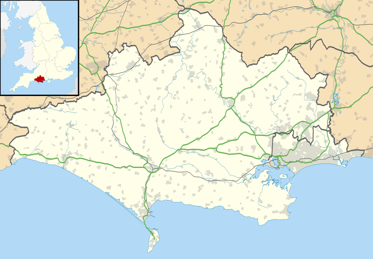
831:
751:
553:
515:
475:
431:
1411:
1101:
921:
871:
791:
761:
1431:
164:
Equirectangular map projection on WGS 84 datum, with N/S stretched 155%
1126:
1081:
1056:
1006:
1001:
986:
821:
756:
746:
711:
1296:
1161:
1111:
1091:
1076:
1066:
906:
901:
876:
841:
776:
721:
716:
211:
Administrative borders and coastline data from
Boundary-Line product.
1326:
1446:
1331:
1286:
1141:
1031:
941:
886:
856:
826:
816:
811:
781:
766:
579:
Click on a date/time to view the file as it appeared at that time.
1491:
1371:
1356:
1351:
1276:
287:
Contains
Ordnance Survey data © Crown copyright and database right
1171:
1156:
736:
144:
1481:
1291:
916:
690:
1281:
1266:
1316:
1301:
1261:
87:(SVG file, nominally 1,425 × 990 pixels, file size: 1.64 MB)
1401:
659:
Updated boundaries reflecting 2019 local government changes
1341:
1321:
1306:
1436:
1386:
1311:
1271:
190:
93:
1476:
1361:
1496:
1426:
1366:
1501:
1406:
1471:
701:
1222:
577:
482:
Creative
Commons Attribution-ShareAlike 3.0 Unported
456:
Creative
Commons Attribution-ShareAlike 3.0 Unported
117:
Commons is a freely licensed media file repository.
1486:
214:All other geographic data from Meridian 2 product.
333:https://creativecommons.org/licenses/by-sa/3.0
98:
1462:Πρότυπο:Location map Ηνωμένο Βασίλειο Ντόρσετ
339:Creative Commons Attribution-Share Alike 3.0
257:
242:
186:
135:
1252:Plantilya:Location map United Kingdom Dorset
352:
231:
196:
14:
299:– to copy, distribute and transmit the work
147:, UK with the following information shown:
46:Size of this PNG preview of this SVG file:
1224:The following other wikis use this file:
1232:قالب:Location map United Kingdom Dorset
357:File:Dorset UK district map (blank).svg
1392:Benutzer:Huligan0/Chapman's Pool
1377:Vorlage:Positionskarte England Dorset
129:
1337:Benutzer:Huligan0/Info Box Halbinsel
280:Attribution-Share Alike 3.0 Unported
238:, created using Ordnance Survey data
570:
268:
263:
13:
1519:
689:{{Information |Description=Map of
385:
379:
254:
130:
80:
1553:
1526:
384:
1422:Benutzer:Huligan0/Pondfield Cove
1397:Benutzer:Huligan0/Worbarrow Tout
370:
310:Under the following conditions:
275:This file is licensed under the
267:
262:
256:
97:
31:
21:
1442:Benutzer:Huligan0/The Pinnacles
1347:Benutzer:Huligan0/Info Box Berg
1242:Шаблон:ПК Великобритания Дорсет
367:
1417:Benutzer:Huligan0/Hobarrow Bay
1382:Benutzer:Huligan0/Egmont Bight
1219:
629:Resized to original dimensions
574:
366:
26:
1:
36:
1412:Benutzer:Huligan0/Brandy Bay
698:
392:Items portrayed in this file
7:
1516:
1432:Benutzer:Huligan0/Hen Cliff
1248:Usage on ceb.wikipedia.org
154:Coastline, lakes and rivers
10:
1558:
1468:Usage on es.wikipedia.org
1453:Usage on el.wikipedia.org
1258:Usage on de.wikipedia.org
1238:Usage on bg.wikipedia.org
1228:Usage on ar.wikipedia.org
324:same or compatible license
138:Dorset UK location map.svg
132:
571:
16:
1297:Portland Bill Lighthouse
667:18:48, 26 September 2010
369:
290:
219:England location map.svg
104:This is a file from the
41:
688:
658:
628:
189:
108:. Information from its
1447:The Pinnacles (Dorset)
1287:Kernkraftwerk Winfrith
892:Corfe Castle (village)
151:Administrative borders
111:description page there
1357:Swyre Head (Lulworth)
1352:Swyre Head (Kingston)
1277:Christchurch (Dorset)
1022:Maiden Castle, Dorset
1147:Sturminster Marshall
1052:Mount Pleasant henge
947:Flagstones Enclosure
637:04:12, 16 April 2019
607:19:26, 22 April 2019
70:2,560 × 1,779 pixels
1482:Dorchester (Dorset)
1292:Bournemouth Airport
305:– to adapt the work
217:Inset derived from
167:Geographic limits:
52:Other resolutions:
1197:West Stour, Dorset
1152:Sturminster Newton
1012:Lytchett Matravers
957:Gillingham, Dorset
937:East Weare Battery
932:East Stour, Dorset
912:Dorchester, Dorset
157:Roads and railways
74:1,425 × 990 pixels
66:1,280 × 889 pixels
62:1,024 × 711 pixels
1545:
1544:
1511:more global usage
1220:Global file usage
1207:Wimborne St Giles
1107:Shaftesbury Abbey
997:Langton Matravers
807:Bradford Peverell
727:Allington, Dorset
696:
521:26 September 2010
466:copyright license
452:copyright license
378:
363:
362:
251:
248:Reusing this file
191:26 September 2010
126:
125:
106:Wikimedia Commons
32:Global file usage
1549:
1527:
1492:Isla de Pórtland
1282:Vitality Stadium
1267:Isle of Portland
1202:Wimborne Minster
1182:West Bay, Dorset
1137:Stourton Caundle
1097:Sandsfoot Castle
1017:Lytchett Minster
972:Isle of Portland
862:Burton Bradstock
742:Batcombe, Dorset
679:
649:
619:
581:
422:copyright status
408:copyright status
376:
346:
343:
340:
337:
334:
326:as the original.
288:
277:Creative Commons
271:
270:
266:
265:
260:
259:
245:
192:
139:
133:
122:
101:
100:
94:
88:
77:
58:640 × 445 pixels
54:320 × 222 pixels
48:800 × 556 pixels
1557:
1556:
1552:
1551:
1550:
1548:
1547:
1546:
1515:
1457:Μουσείο Αρμάτων
1327:St Alban’s Head
1317:Isle of Purbeck
1302:Old Harry Rocks
1262:Brownsea Island
1218:
1177:Wareham, Dorset
1122:St Ives, Dorset
1072:Portland Castle
1062:Old Harry Rocks
977:Iwerne Courtney
852:Buckland Newton
847:Buckhorn Weston
837:Brownsea Island
797:Bourton, Dorset
772:Blandford Forum
697:
685:
677:
655:
647:
625:
617:
573:
572:
569:
568:
567:
566:
565:
564:
563:
562:
560:
550:
549:
548:
546:
531:
530:
529:
528:
527:
526:
525:
524:
522:
512:
511:
510:
508:
493:
492:
491:
490:
489:
488:
487:
486:
484:
472:
471:
470:
468:
449:
448:
447:
446:
445:
444:
443:
442:
440:
428:
427:
426:
424:
405:
404:
403:
402:
401:
399:
383:
382:
381:
364:
348:
347:
344:
341:
338:
335:
332:
331:
289:
286:
283:
272:
202:Ordnance Survey
137:
128:
127:
116:
115:
114:is shown below.
90:
86:
79:
78:
51:
12:
11:
5:
1555:
1543:
1542:
1539:
1535:
1534:
1531:
1518:
1513:of this file.
1507:
1506:
1505:
1504:
1499:
1494:
1489:
1484:
1479:
1474:
1466:
1465:
1464:
1459:
1451:
1450:
1449:
1444:
1439:
1434:
1429:
1424:
1419:
1414:
1409:
1404:
1402:Worbarrow Tout
1399:
1394:
1389:
1384:
1379:
1374:
1369:
1364:
1359:
1354:
1349:
1344:
1339:
1334:
1332:Chapman’s Pool
1329:
1324:
1319:
1314:
1309:
1304:
1299:
1294:
1289:
1284:
1279:
1274:
1269:
1264:
1256:
1255:
1254:
1246:
1245:
1244:
1236:
1235:
1234:
1221:
1216:to this file.
1210:
1209:
1204:
1199:
1194:
1189:
1184:
1179:
1174:
1169:
1164:
1159:
1154:
1149:
1144:
1139:
1134:
1129:
1124:
1119:
1114:
1109:
1104:
1099:
1094:
1089:
1084:
1079:
1074:
1069:
1064:
1059:
1054:
1049:
1044:
1039:
1037:Maumbury Rings
1034:
1029:
1024:
1019:
1014:
1009:
1004:
999:
994:
989:
984:
982:Iwerne Minster
979:
974:
969:
967:Hinton St Mary
964:
962:Hilton, Dorset
959:
954:
949:
944:
939:
934:
929:
924:
919:
914:
909:
904:
899:
894:
889:
884:
879:
874:
869:
864:
859:
854:
849:
844:
839:
834:
829:
824:
819:
814:
809:
804:
802:Bradford Abbas
799:
794:
789:
784:
779:
774:
769:
764:
759:
754:
749:
744:
739:
734:
729:
724:
719:
714:
707:is available.
700:
695:
694:
687:
683:
680:
674:
669:
664:
661:
660:
657:
653:
650:
644:
639:
634:
631:
630:
627:
623:
620:
614:
609:
604:
600:
599:
596:
593:
590:
587:
584:
576:
561:
558:
556:
555:
554:
552:
551:
547:
542:
540:
539:
538:
537:
535:
523:
520:
518:
517:
516:
514:
513:
509:
504:
502:
501:
500:
499:
497:
485:
480:
478:
477:
476:
474:
473:
469:
464:
462:
461:
460:
459:
457:
453:
441:
436:
434:
433:
432:
430:
429:
425:
420:
418:
417:
416:
415:
413:
409:
400:
395:
393:
390:
389:
388:
387:
375:
374:
371:
368:
361:
360:
354:
353:Other versions
350:
349:
330:
329:
328:
327:
317:
308:
307:
306:
300:
293:You are free:
284:
274:
273:
255:
252:
240:
239:
233:
229:
228:
227:
226:
215:
212:
198:
194:
193:
188:
184:
183:
182:
181:
178:
175:
172:
162:
161:
158:
155:
152:
140:
131:
124:
123:
102:
92:
91:
45:
40:
39:
34:
29:
24:
19:
9:
6:
4:
3:
2:
1554:
1540:
1537:
1536:
1532:
1529:
1528:
1525:
1522:
1514:
1512:
1503:
1500:
1498:
1495:
1493:
1490:
1488:
1485:
1483:
1480:
1478:
1475:
1473:
1470:
1469:
1467:
1463:
1460:
1458:
1455:
1454:
1452:
1448:
1445:
1443:
1440:
1438:
1435:
1433:
1430:
1428:
1425:
1423:
1420:
1418:
1415:
1413:
1410:
1408:
1405:
1403:
1400:
1398:
1395:
1393:
1390:
1388:
1385:
1383:
1380:
1378:
1375:
1373:
1372:Parson’s Barn
1370:
1368:
1365:
1363:
1360:
1358:
1355:
1353:
1350:
1348:
1345:
1343:
1342:Peveril Point
1340:
1338:
1335:
1333:
1330:
1328:
1325:
1323:
1322:Worbarrow Bay
1320:
1318:
1315:
1313:
1310:
1308:
1307:Poole Harbour
1305:
1303:
1300:
1298:
1295:
1293:
1290:
1288:
1285:
1283:
1280:
1278:
1275:
1273:
1270:
1268:
1265:
1263:
1260:
1259:
1257:
1253:
1250:
1249:
1247:
1243:
1240:
1239:
1237:
1233:
1230:
1229:
1227:
1226:
1225:
1217:
1215:
1208:
1205:
1203:
1200:
1198:
1195:
1193:
1190:
1188:
1187:West Lulworth
1185:
1183:
1180:
1178:
1175:
1173:
1170:
1168:
1167:Verne Citadel
1165:
1163:
1160:
1158:
1155:
1153:
1150:
1148:
1145:
1143:
1140:
1138:
1135:
1133:
1132:Stour Provost
1130:
1128:
1125:
1123:
1120:
1118:
1117:Shillingstone
1115:
1113:
1110:
1108:
1105:
1103:
1100:
1098:
1095:
1093:
1090:
1088:
1087:Purse Caundle
1085:
1083:
1080:
1078:
1075:
1073:
1070:
1068:
1065:
1063:
1060:
1058:
1055:
1053:
1050:
1048:
1045:
1043:
1042:Melbury Abbas
1040:
1038:
1035:
1033:
1030:
1028:
1027:Maiden Newton
1025:
1023:
1020:
1018:
1015:
1013:
1010:
1008:
1005:
1003:
1000:
998:
995:
993:
992:Kington Magna
990:
988:
985:
983:
980:
978:
975:
973:
970:
968:
965:
963:
960:
958:
955:
953:
950:
948:
945:
943:
940:
938:
935:
933:
930:
928:
925:
923:
920:
918:
915:
913:
910:
908:
905:
903:
900:
898:
895:
893:
890:
888:
885:
883:
880:
878:
875:
873:
870:
868:
865:
863:
860:
858:
855:
853:
850:
848:
845:
843:
840:
838:
835:
833:
830:
828:
825:
823:
820:
818:
815:
813:
810:
808:
805:
803:
800:
798:
795:
793:
790:
788:
787:Bothenhampton
785:
783:
780:
778:
775:
773:
770:
768:
765:
763:
760:
758:
755:
753:
750:
748:
745:
743:
740:
738:
735:
733:
732:Alton Pancras
730:
728:
725:
723:
720:
718:
715:
713:
710:
709:
708:
706:
692:
686:
681:
675:
673:
670:
668:
665:
663:
662:
656:
654:The Equalizer
651:
645:
643:
640:
638:
635:
633:
632:
626:
624:The Equalizer
621:
615:
613:
610:
608:
605:
602:
601:
597:
594:
591:
588:
585:
583:
582:
580:
559:image/svg+xml
557:
545:
541:
519:
507:
503:
483:
479:
467:
463:
439:
435:
423:
419:
398:
394:
391:
372:
365:
358:
355:
351:
336:CC BY-SA 3.0
325:
321:
318:
315:
312:
311:
309:
304:
301:
298:
295:
294:
292:
291:
285:Attribution:
281:
278:
261:
253:
249:
244:
241:
237:
234:
230:
224:
220:
216:
213:
210:
209:
208:
206:
203:
199:
195:
185:
180:South: 50.50N
179:
177:North: 51.10N
176:
173:
170:
169:
168:
165:
159:
156:
153:
150:
149:
148:
146:
141:
134:
120:
113:
112:
107:
103:
96:
95:
89:
84:
83:Original file
75:
71:
67:
63:
59:
55:
49:
44:
38:
35:
33:
30:
28:
25:
23:
20:
18:
15:
1523:
1520:
1508:
1437:Hobarrow Bay
1387:Egmont Bight
1312:Durlston Bay
1272:Corfe Castle
1223:
1211:
1192:West Orchard
1047:Milton Abbas
952:Fortuneswell
927:East Orchard
897:Corfe Mullen
882:Chesil Beach
867:Cann, Dorset
832:Broadwindsor
752:Beer Hackett
702:
676:1,425 × 990
646:1,338 × 982
616:1,425 × 990
578:
575:File history
319:
313:
302:
296:
200:
166:
163:
142:
119:You can help
109:
81:
22:File history
1477:Bournemouth
1362:Anvil Point
1102:Shaftesbury
922:Durdle Door
872:Cerne Abbas
792:Bournemouth
762:Bettiscombe
438:copyrighted
412:copyrighted
359:- Blank map
320:share alike
314:attribution
174:East: 1.65W
171:West: 2.99W
160:Urban areas
136:Description
1497:Lyme Regis
1427:Brandy Bay
1367:Cow Corner
1214:more links
1127:Stalbridge
1082:Puddletown
1057:Netherbury
1007:Lyme Regis
1002:Longburton
987:Kimmeridge
822:Broadmayne
757:Bere Regis
747:Beaminster
712:Abbotsbury
699:File usage
592:Dimensions
544:media type
534:media type
243:Permission
27:File usage
1502:Osmington
1407:Gad Cliff
1162:Tolpuddle
1112:Sherborne
1092:Sandbanks
1077:Poundbury
1067:Portesham
907:Cranborne
902:Corscombe
877:Charmouth
842:Bryanston
777:Bloxworth
722:Alderholt
717:Affpuddle
705:full list
684:Nilfanion
678:(1.73 MB)
648:(1.67 MB)
618:(1.64 MB)
589:Thumbnail
586:Date/Time
506:inception
496:inception
236:Nilfanion
1517:Metadata
1472:Weymouth
1142:Studland
1032:Marnhull
942:Ferndown
887:Chideock
857:Burstock
827:Broadwey
817:Bridport
812:Bradpole
782:Boscombe
767:Bincombe
380:Usama777
373:Captions
303:to remix
297:to share
282:license.
223:Spischot
205:OpenData
37:Metadata
1172:Verwood
1157:Swanage
737:Ashmore
603:current
598:Comment
397:depicts
377:English
143:Map of
85:
1538:Height
917:Dorset
691:Dorset
232:Author
197:Source
145:Dorset
1530:Width
1509:View
1487:Poole
1212:View
1533:1425
595:User
345:true
342:true
187:Date
17:File
1541:990
221:by
207:.
72:|
68:|
64:|
60:|
56:|
50:.
250:)
246:(
225:.
121:.
76:.

.svg)