672:"}},"text\/plain":{"en":{"":"inception"}}},"{\"value\":{\"time\":\"+2010-11-16T00:00:00Z\",\"timezone\":0,\"before\":0,\"after\":0,\"precision\":11,\"calendarmodel\":\"http:\\\/\\\/www.wikidata.org\\\/entity\\\/Q1985727\"},\"type\":\"time\"}":{"text\/html":{"en":{"P571":"16 November 2010"}},"text\/plain":{"en":{"P571":"16 November 2010"}}}}": -->
38:
452:
364:
309:
224:
464:","P2093":"Nilfanion"}},"text\/plain":{"en":{"P4174":"Nilfanion","P2093":"Nilfanion"}}},"{\"value\":{\"entity-type\":\"property\",\"numeric-id\":2093,\"id\":\"P2093\"},\"type\":\"wikibase-entityid\"}":{"text\/html":{"en":{"":"
229:
94:
611:"}},"text\/plain":{"en":{"P275":"Creative Commons Attribution-ShareAlike 3.0 Unported"}}},"{\"value\":{\"entity-type\":\"item\",\"numeric-id\":50829104,\"id\":\"Q50829104\"},\"type\":\"wikibase-entityid\"}":{"text\/html":{"en":{"P275":"
607:"}},"text\/plain":{"en":{"":"copyright license"}}},"{\"value\":{\"entity-type\":\"item\",\"numeric-id\":14946043,\"id\":\"Q14946043\"},\"type\":\"wikibase-entityid\"}":{"text\/html":{"en":{"P275":"
563:"}},"text\/plain":{"en":{"":"copyright status"}}},"{\"value\":{\"entity-type\":\"item\",\"numeric-id\":50423863,\"id\":\"Q50423863\"},\"type\":\"wikibase-entityid\"}":{"text\/html":{"en":{"P6216":"
468:"}},"text\/plain":{"en":{"":"author name string"}}},"{\"value\":{\"entity-type\":\"property\",\"numeric-id\":2699,\"id\":\"P2699\"},\"type\":\"wikibase-entityid\"}":{"text\/html":{"en":{"":"
456:"}},"text\/plain":{"en":{"":"creator"}}},"{\"value\":{\"entity-type\":\"property\",\"numeric-id\":4174,\"id\":\"P4174\"},\"type\":\"wikibase-entityid\"}":{"text\/html":{"en":{"":"
559:
472:"}},"text\/plain":{"en":{"":"URL"}}},"{\"value\":\"https:\\\/\\\/commons.wikimedia.org\\\/wiki\\\/user:Nilfanion\",\"type\":\"string\"}":{"text\/html":{"en":{"P2699":"
460:"}},"text\/plain":{"en":{"":"Wikimedia username"}}},"{\"value\":\"Nilfanion\",\"type\":\"string\"}":{"text\/html":{"en":{"P4174":"
270:– You must give appropriate credit, provide a link to the license, and indicate if changes were made. You may do so in any reasonable manner, but not in any way that suggests the licensor endorses you or your use.
401:
461:
376:
612:
608:
564:
473:
1293:
784:
560:
469:
465:
457:
669:
604:
453:
1606:
1770:
326:
1381:
68:
64:
60:
56:
52:
48:
42:
105:
476:"}},"text\/plain":{"en":{"P2699":"https:\/\/commons.wikimedia.org\/wiki\/user:Nilfanion"}}}}": -->
77:
615:"}},"text\/plain":{"en":{"P275":"GNU Free Documentation License, version 1.2 or later"}}}}": -->
382:
324:; with no Invariant Sections, no Front-Cover Texts, and no Back-Cover Texts. A copy of the license is included in the section entitled
179:
655:
638:
590:
1671:
277:
574:
538:
525:
510:
876:
316:
679:
622:
483:
442:
1601:
1171:
393:
517:
239:
1661:
1596:
783:
More than 100 pages use this file. The following list shows the first 100 pages that use this file only. A
321:
276:– If you remix, transform, or build upon the material, you must distribute your contributions under the
1241:
986:
806:
567:"}},"text\/plain":{"en":{"P6216":"copyrighted"}}}}": -->
1351:
747:
742:
37:
1331:
991:
168:
113:
1501:
1151:
1211:
996:
801:
545:
370:
1731:
1691:
1371:
1361:
1231:
1121:
1111:
314:
Permission is granted to copy, distribute and/or modify this document under the terms of the
1271:
1256:
1191:
1136:
1126:
1076:
966:
236:
8:
1416:
1206:
1181:
1016:
946:
891:
841:
816:
1236:
1116:
1046:
1011:
916:
1471:
1246:
1201:
1166:
1051:
976:
936:
826:
796:
211:
I, the copyright holder of this work, hereby publish it under the following licenses:
100:
1681:
1446:
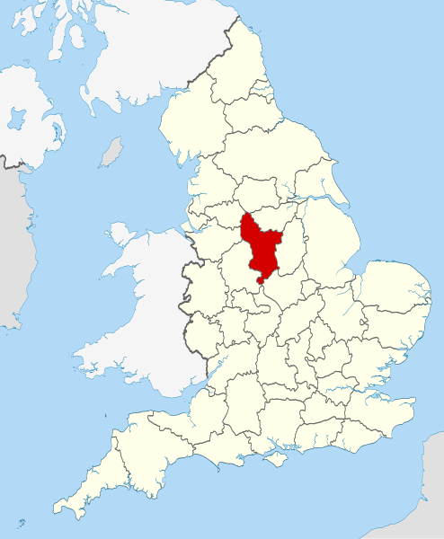
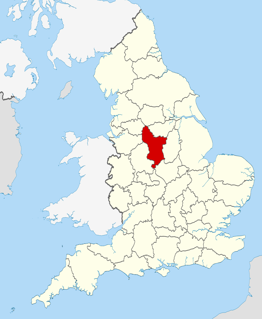
791:
432:
1391:
1286:
1226:
1216:
1036:
1021:
1001:
846:
165:
1616:
1261:
1091:
1041:
836:
770:
195:
1516:
981:
831:
758:
765:== Summary == {{Information |Description=Location of the ceremonial county of
1196:
851:
1086:
1061:
901:
866:
402:
Commons:Valued image candidates/Locator maps of
English ceremonial counties
689:
649:
632:
584:
493:
1141:
1081:
861:
811:
143:
1276:
1251:
1221:
1186:
1146:
1106:
1071:
1066:
951:
941:
921:
906:
896:
881:
766:
185:
Irish, French and Isle of Man coastlines, Lough Neagh and Irish border
1656:
1056:
1031:
1006:
926:
911:
886:
821:
358:
303:
1281:
1176:
1101:
1096:
971:
856:
715:
Click on a date/time to view the file as it appeared at that time.
1476:
1626:
1266:
1156:
961:
956:
381:
on
Wikimedia Commons. The image set has been assessed under the
1161:
931:
871:
1131:
82:(SVG file, nominally 1,108 × 1,345 pixels, file size: 302 KB)
1646:
1026:
154:
88:
1751:
1721:
1711:
1636:
1566:
1536:
1426:
1401:
1341:
1761:
1741:
1701:
1586:
1576:
1556:
1546:
1526:
1511:
1491:
1466:
1456:
1436:
1411:
1321:
1311:
426:
Add a one-line explanation of what this file represents
781:
474:
https:\/\/commons.wikimedia.org\/wiki\/user:Nilfanion
1481:
1302:
713:
656:
639:
Creative
Commons Attribution-ShareAlike 3.0 Unported
613:
609:
Creative
Commons Attribution-ShareAlike 3.0 Unported
320:, Version 1.2 or any later version published by the
112:
Commons is a freely licensed media file repository.
377:Locator maps of the Ceremonial counties of England
1662:Apvienotās Karalistes administratīvais iedalījums
1417:Llista de comtats cerimonials d'Anglaterra
369:This is one of the images forming part of the
287:https://creativecommons.org/licenses/by-sa/3.0
93:
293:Creative Commons Attribution-Share Alike 3.0
217:
150:
135:
546:https://commons.wikimedia.org/user:Nilfanion
191:
160:
14:
253:– to copy, distribute and transmit the work
41:Size of this PNG preview of this SVG file:
352:You may select the license of your choice.
1472:Anexo:Condados ceremoniales de Inglaterra
1304:The following other wikis use this file:
180:National Geospatial-Intelligence Agency
1447:Grade I listed buildings in Derbyshire
1682:Comtats ceremonials d'Anglatèrra
142:Location of the ceremonial county of
124:
1392:Lec'hanvioù kembraek e Bro-Saoz
332:http://www.gnu.org/copyleft/fdl.html
240:Attribution-Share Alike 3.0 Unported
706:
228:
223:
13:
1517:Englannin muodolliset kreivikunnat
877:Biggin (Dovedale and Parwich Ward)
431:
425:
390:
351:
214:
210:
175:County boundaries and GB coastline
138:Derbyshire UK locator map 2010.svg
125:
75:
1782:
1348:Usage on be-tarask.wikipedia.org
430:
416:
362:
308:
307:
264:Under the following conditions:
235:This file is licensed under the
227:
222:
216:
92:
31:
21:
1172:Shining Cliff Woods, Derbyshire
413:
363:
1299:
710:
412:
399:You can see its nomination at
394:Ceremonial counties of England
387:the most valued set on Commons
338:GNU Free Documentation License
327:GNU Free Documentation License
317:GNU Free Documentation License
26:
1:
778:
438:Items portrayed in this file
204:
7:
1748:Usage on sco.wikipedia.org
1728:Usage on pnb.wikipedia.org
1718:Usage on pl.wiktionary.org
1708:Usage on pl.wikivoyage.org
1633:Usage on lld.wikipedia.org
1563:Usage on hak.wikipedia.org
1533:Usage on fr.wiktionary.org
1443:Usage on dag.wikipedia.org
1423:Usage on ceb.wikipedia.org
1398:Usage on br.wiktionary.org
1338:Usage on ast.wikipedia.org
10:
1787:
1758:Usage on sh.wikipedia.org
1738:Usage on pt.wikipedia.org
1698:Usage on pl.wikipedia.org
1688:Usage on os.wikipedia.org
1678:Usage on oc.wikipedia.org
1668:Usage on mr.wikipedia.org
1653:Usage on lv.wikipedia.org
1643:Usage on lt.wikipedia.org
1623:Usage on la.wikipedia.org
1613:Usage on ko.wikipedia.org
1593:Usage on ja.wikipedia.org
1583:Usage on ia.wikipedia.org
1573:Usage on hu.wikipedia.org
1553:Usage on gl.wikipedia.org
1543:Usage on ga.wikipedia.org
1523:Usage on fr.wikipedia.org
1508:Usage on fi.wikipedia.org
1498:Usage on fa.wikipedia.org
1488:Usage on eu.wikipedia.org
1463:Usage on es.wikipedia.org
1453:Usage on eo.wikipedia.org
1433:Usage on cs.wikipedia.org
1408:Usage on ca.wikipedia.org
1388:Usage on br.wikipedia.org
1378:Usage on bn.wikipedia.org
1368:Usage on bg.wikipedia.org
1358:Usage on be.wikipedia.org
1328:Usage on ar.wikipedia.org
1318:Usage on an.wikipedia.org
1308:Usage on af.wikipedia.org
278:same or compatible license
132:
127:
1242:Tintwistle Rural District
987:Hartington Nether Quarter
807:Aldercar and Langley Mill
707:
383:valued image set criteria
16:
1152:Robin Hood's Stride
992:Hartington Upper Quarter
769:within England. |Source=
415:
374:
322:Free Software Foundation
244:
99:This is a file from the
36:
764:
743:22:33, 23 November 2010
153:
103:. Information from its
1212:Sudbury Rural District
997:Hartshorne, Derbyshire
802:Abney and Abney Grange
400:
106:description page there
1607:Category:ダービーシャー出身の人物
1477:North East Derbyshire
1232:Thornhill, Derbyshire
1122:Repton Rural District
1112:Radbourne, Derbyshire
1627:Derbiensis comitatus
1272:Walton, Chesterfield
1257:Tunstead, Derbyshire
1192:Stainsby, Derbyshire
1137:Ridgeway, Derbyshire
1127:Rhodeswood Reservoir
1077:Newhaven, Derbyshire
967:Draycott, Derbyshire
392:Locator maps of the
69:1,108 × 1,345 pixels
65:1,687 × 2,048 pixels
1207:Sudbury, Derbyshire
1182:Shirley, Derbyshire
1017:Horsley, Derbyshire
947:Crowden, Derbyshire
892:Blackwell, Bolsover
842:Ashgate, Derbyshire
817:Aldwark, Derbyshire
259:– to adapt the work
47:Other resolutions:
1237:Thorpe, Derbyshire
1117:Rattle, Derbyshire
1047:Litton, Derbyshire
1012:Hopton, Derbyshire
917:Brough and Shatton
792:Abbot's Chair
526:author name string
511:Wikimedia username
466:author name string
458:Wikimedia username
389:within the scope:
385:and is considered
61:843 × 1,024 pixels
1771:more global usage
1300:Global file usage
1247:Torside Reservoir
1202:Stanton by Bridge
1167:Sett Valley Trail
1052:Longdendale Trail
977:Flagg, Derbyshire
937:Combs, Derbyshire
827:Alton, Derbyshire
797:Abney, Derbyshire
776:
623:copyright license
605:copyright license
424:
410:
409:
349:
348:
201:
200:
121:
120:
101:Wikimedia Commons
32:Global file usage
1778:
1602:Category:ダービーシャー
1287:Windgather Rocks
1227:Temple Normanton
1217:Sutton Scarsdale
1037:Leam, Derbyshire
1022:Howden Reservoir
1002:High Peak Estate
847:Aston, High Peak
755:
717:
695:16 November 2010
575:copyright status
561:copyright status
548:
543:
533:
530:
520:
515:
422:
371:Valued image set
366:
365:
359:
345:
342:
339:
336:
333:
311:
310:
304:
300:
297:
294:
291:
288:
280:as the original.
237:Creative Commons
231:
230:
226:
225:
220:
219:
156:
155:16 November 2010
139:
133:
117:
96:
95:
89:
83:
72:
57:633 × 768 pixels
53:395 × 480 pixels
49:198 × 240 pixels
43:494 × 600 pixels
1786:
1785:
1781:
1780:
1779:
1777:
1776:
1775:
1298:
1262:Tunstead Milton
1092:Peakshole Water
1042:Little Hayfield
837:Ash, Derbyshire
777:
771:Ordnance Survey
761:
753:
709:
708:
705:
704:
703:
702:
701:
700:
699:
698:
696:
686:
685:
684:
682:
667:
666:
665:
664:
663:
662:
661:
660:
658:
647:
646:
645:
644:
643:
641:
629:
628:
627:
625:
602:
601:
600:
599:
598:
597:
596:
595:
593:
581:
580:
579:
577:
558:
557:
556:
555:
554:
553:
552:
551:
550:
549:
544:
541:
535:
534:
531:
528:
522:
521:
516:
513:
504:
503:
502:
500:
490:
489:
488:
486:
451:
450:
449:
448:
447:
445:
429:
428:
427:
404:
397:
380:
355:
354:
353:
343:
340:
337:
334:
331:
302:
301:
298:
295:
292:
289:
286:
285:
243:
232:
213:
212:
207:
202:
166:Ordnance Survey
146:within England.
137:
130:
123:
122:
111:
110:
109:is shown below.
85:
81:
74:
73:
46:
12:
11:
5:
1784:
1773:of this file.
1767:
1766:
1765:
1764:
1756:
1755:
1754:
1746:
1745:
1744:
1736:
1735:
1734:
1726:
1725:
1724:
1716:
1715:
1714:
1706:
1705:
1704:
1696:
1695:
1694:
1686:
1685:
1684:
1676:
1675:
1674:
1666:
1665:
1664:
1659:
1651:
1650:
1649:
1641:
1640:
1639:
1631:
1630:
1629:
1621:
1620:
1619:
1611:
1610:
1609:
1604:
1599:
1591:
1590:
1589:
1581:
1580:
1579:
1571:
1570:
1569:
1561:
1560:
1559:
1551:
1550:
1549:
1541:
1540:
1539:
1531:
1530:
1529:
1521:
1520:
1519:
1514:
1506:
1505:
1504:
1496:
1495:
1494:
1486:
1485:
1484:
1479:
1474:
1469:
1461:
1460:
1459:
1451:
1450:
1449:
1441:
1440:
1439:
1431:
1430:
1429:
1421:
1420:
1419:
1414:
1406:
1405:
1404:
1396:
1395:
1394:
1386:
1385:
1384:
1376:
1375:
1374:
1366:
1365:
1364:
1356:
1355:
1354:
1346:
1345:
1344:
1336:
1335:
1334:
1326:
1325:
1324:
1316:
1315:
1314:
1301:
1296:to this file.
1290:
1289:
1284:
1279:
1274:
1269:
1264:
1259:
1254:
1249:
1244:
1239:
1234:
1229:
1224:
1219:
1214:
1209:
1204:
1199:
1194:
1189:
1184:
1179:
1174:
1169:
1164:
1159:
1154:
1149:
1144:
1139:
1134:
1129:
1124:
1119:
1114:
1109:
1104:
1099:
1094:
1089:
1084:
1079:
1074:
1069:
1064:
1059:
1054:
1049:
1044:
1039:
1034:
1029:
1024:
1019:
1014:
1009:
1004:
999:
994:
989:
984:
982:Greenhill Lane
979:
974:
969:
964:
959:
954:
949:
944:
939:
934:
929:
924:
919:
914:
909:
904:
899:
894:
889:
884:
879:
874:
869:
864:
859:
854:
849:
844:
839:
834:
832:Arkwright Town
829:
824:
819:
814:
809:
804:
799:
794:
787:is available.
780:
775:
774:
763:
759:
756:
752:1,108 × 1,345
750:
745:
740:
736:
735:
732:
729:
726:
723:
720:
712:
697:
694:
692:
691:
690:
688:
687:
683:
678:
676:
675:
674:
673:
671:
659:
654:
652:
651:
650:
648:
642:
637:
635:
634:
633:
631:
630:
626:
621:
619:
618:
617:
616:
614:
610:
606:
594:
589:
587:
586:
585:
583:
582:
578:
573:
571:
570:
569:
568:
566:
562:
537:
536:
524:
523:
509:
508:
507:
506:
505:
501:
498:
496:
495:
494:
492:
491:
487:
482:
480:
479:
478:
477:
475:
471:
467:
463:
459:
455:
446:
441:
439:
436:
435:
434:
433:
421:
420:
417:
414:
408:
407:
367:
350:
347:
346:
312:
284:
283:
282:
281:
271:
262:
261:
260:
254:
247:You are free:
234:
233:
215:
209:
208:
206:
203:
199:
198:
193:
189:
188:
187:
186:
177:
176:
162:
158:
157:
152:
148:
147:
140:
131:
129:
126:
119:
118:
97:
87:
86:
40:
35:
34:
29:
24:
19:
9:
6:
4:
3:
2:
1783:
1774:
1772:
1763:
1760:
1759:
1757:
1753:
1750:
1749:
1747:
1743:
1740:
1739:
1737:
1733:
1730:
1729:
1727:
1723:
1720:
1719:
1717:
1713:
1710:
1709:
1707:
1703:
1700:
1699:
1697:
1693:
1690:
1689:
1687:
1683:
1680:
1679:
1677:
1673:
1670:
1669:
1667:
1663:
1660:
1658:
1655:
1654:
1652:
1648:
1645:
1644:
1642:
1638:
1635:
1634:
1632:
1628:
1625:
1624:
1622:
1618:
1615:
1614:
1612:
1608:
1605:
1603:
1600:
1598:
1595:
1594:
1592:
1588:
1585:
1584:
1582:
1578:
1575:
1574:
1572:
1568:
1565:
1564:
1562:
1558:
1555:
1554:
1552:
1548:
1545:
1544:
1542:
1538:
1535:
1534:
1532:
1528:
1525:
1524:
1522:
1518:
1515:
1513:
1510:
1509:
1507:
1503:
1500:
1499:
1497:
1493:
1490:
1489:
1487:
1483:
1480:
1478:
1475:
1473:
1470:
1468:
1465:
1464:
1462:
1458:
1455:
1454:
1452:
1448:
1445:
1444:
1442:
1438:
1435:
1434:
1432:
1428:
1425:
1424:
1422:
1418:
1415:
1413:
1410:
1409:
1407:
1403:
1400:
1399:
1397:
1393:
1390:
1389:
1387:
1383:
1380:
1379:
1377:
1373:
1370:
1369:
1367:
1363:
1360:
1359:
1357:
1353:
1350:
1349:
1347:
1343:
1340:
1339:
1337:
1333:
1330:
1329:
1327:
1323:
1320:
1319:
1317:
1313:
1310:
1309:
1307:
1306:
1305:
1297:
1295:
1288:
1285:
1283:
1280:
1278:
1275:
1273:
1270:
1268:
1265:
1263:
1260:
1258:
1255:
1253:
1250:
1248:
1245:
1243:
1240:
1238:
1235:
1233:
1230:
1228:
1225:
1223:
1220:
1218:
1215:
1213:
1210:
1208:
1205:
1203:
1200:
1198:
1197:Stainsby Mill
1195:
1193:
1190:
1188:
1185:
1183:
1180:
1178:
1175:
1173:
1170:
1168:
1165:
1163:
1160:
1158:
1155:
1153:
1150:
1148:
1145:
1143:
1140:
1138:
1135:
1133:
1130:
1128:
1125:
1123:
1120:
1118:
1115:
1113:
1110:
1108:
1105:
1103:
1100:
1098:
1095:
1093:
1090:
1088:
1085:
1083:
1080:
1078:
1075:
1073:
1070:
1068:
1065:
1063:
1060:
1058:
1055:
1053:
1050:
1048:
1045:
1043:
1040:
1038:
1035:
1033:
1030:
1028:
1025:
1023:
1020:
1018:
1015:
1013:
1010:
1008:
1005:
1003:
1000:
998:
995:
993:
990:
988:
985:
983:
980:
978:
975:
973:
970:
968:
965:
963:
960:
958:
955:
953:
950:
948:
945:
943:
940:
938:
935:
933:
930:
928:
925:
923:
920:
918:
915:
913:
910:
908:
905:
903:
900:
898:
895:
893:
890:
888:
885:
883:
880:
878:
875:
873:
870:
868:
865:
863:
860:
858:
855:
853:
852:Ault Hucknall
850:
848:
845:
843:
840:
838:
835:
833:
830:
828:
825:
823:
820:
818:
815:
813:
810:
808:
805:
803:
800:
798:
795:
793:
790:
789:
788:
786:
773:: *County bou
772:
768:
762:
757:
751:
749:
746:
744:
741:
738:
737:
733:
730:
727:
724:
721:
719:
718:
716:
693:
681:
677:
657:
653:
640:
636:
624:
620:
592:
588:
576:
572:
547:
540:
527:
519:
512:
497:
485:
481:
444:
440:
437:
418:
411:
406:
403:
396:
395:
388:
384:
379:
378:
372:
368:
361:
360:
357:
329:
328:
323:
319:
318:
313:
306:
305:
290:CC BY-SA 3.0
279:
275:
272:
269:
266:
265:
263:
258:
255:
252:
249:
248:
246:
245:
241:
238:
221:
197:
194:
190:
184:
183:
182:
181:
174:
173:
172:
170:
167:
163:
159:
149:
145:
141:
134:
115:
108:
107:
102:
98:
91:
90:
84:
79:
78:Original file
70:
66:
62:
58:
54:
50:
44:
39:
33:
30:
28:
25:
23:
20:
18:
15:
1768:
1382:ডার্বিশায়ার
1303:
1291:
1087:Padley Gorge
1062:Lumford Mill
902:Brackenfield
867:Bearwardcote
782:
714:
711:File history
398:
391:
386:
375:
356:
325:
315:
273:
267:
256:
250:
178:
164:
114:You can help
104:
76:
22:File history
1142:River Amber
1082:Old Glossop
862:Barlborough
812:Alderwasley
591:copyrighted
565:copyrighted
274:share alike
268:attribution
136:Description
1762:Derbyshire
1752:Derbyshire
1742:Derbyshire
1722:Derbyshire
1712:Derbyshire
1702:Derbyshire
1647:Derbišyras
1637:Derbyshire
1587:Derbyshire
1577:Derbyshire
1567:Derbyshire
1557:Derbyshire
1547:Derbyshire
1537:Derbyshire
1527:Derbyshire
1512:Derbyshire
1492:Derbyshire
1467:Derbyshire
1457:Derbyshire
1437:Derbyshire
1427:Derbyshire
1412:Derbyshire
1402:Derbyshire
1342:Derbyshire
1322:Derbyshire
1312:Derbyshire
1294:more links
1277:Wessington
1252:Trent Lock
1222:Taddington
1187:Sparrowpit
1147:River Sett
1107:Poolsbrook
1072:Netherseal
1067:Minninglow
952:Derbyshire
942:Cressbrook
922:Brushfield
907:Bradbourne
897:Boylestone
882:Birch Vale
779:File usage
767:Derbyshire
728:Dimensions
499:some value
144:Derbyshire
27:File usage
1672:डर्बीशायर
1657:Dārbišīra
1332:ديربيشاير
1057:Lose Hill
1032:Kedleston
1007:Holmewood
927:Butterley
912:Breadsall
887:Birchover
822:Alkmonton
785:full list
760:Nilfanion
725:Thumbnail
722:Date/Time
680:inception
670:inception
532:Nilfanion
518:Nilfanion
462:Nilfanion
205:Licensing
196:Nilfanion
1732:ڈربیشائر
1692:Дербишир
1502:داربیشر
1372:Дарбишър
1362:Дэрбішыр
1352:Дэрбішыр
1282:Win Hill
1177:Shirland
1102:Pilsbury
1097:Pikehall
972:Egginton
857:Ballidon
754:(302 KB)
419:Captions
257:to remix
251:to share
242:license.
169:OpenData
1597:ダービーシャー
1482:Erewash
1267:Unstone
1157:Rowarth
962:Doe Lea
957:Dinting
739:current
734:Comment
484:creator
454:creator
443:depicts
423:English
128:Summary
80:
1162:Rushop
932:Calver
872:Beeley
192:Author
161:Source
1769:View
1292:View
1132:Riber
1617:더비셔주
1027:Ible
731:User
344:true
341:true
335:GFDL
299:true
296:true
151:Date
17:File
539:URL
470:URL
542::
529::
514::
405:.
373::
171::
67:|
63:|
59:|
55:|
51:|
45:.
330:.
116:.
71:.
Text is available under the Creative Commons Attribution-ShareAlike License. Additional terms may apply.
