520:"}},"text\/plain":{"en":{"":"inception"}}},"{\"value\":{\"time\":\"+2010-09-26T00:00:00Z\",\"timezone\":0,\"before\":0,\"after\":0,\"precision\":11,\"calendarmodel\":\"http:\\\/\\\/www.wikidata.org\\\/entity\\\/Q1985727\"},\"type\":\"time\"}":{"text\/html":{"en":{"P571":"26 September 2010"}},"text\/plain":{"en":{"P571":"26 September 2010"}}}}": -->
38:
253:
259:
264:
94:
558:"}},"text\/plain":{"en":{"":"media type"}}},"{\"value\":\"image\\\/svg+xml\",\"type\":\"string\"}":{"text\/html":{"en":{"P1163":"image\/svg+xml"}},"text\/plain":{"en":{"P1163":"image\/svg+xml"}}}}": -->
476:"}},"text\/plain":{"en":{"":"copyright license"}}},"{\"value\":{\"entity-type\":\"item\",\"numeric-id\":14946043,\"id\":\"Q14946043\"},\"type\":\"wikibase-entityid\"}":{"text\/html":{"en":{"P275":"
432:"}},"text\/plain":{"en":{"":"copyright status"}}},"{\"value\":{\"entity-type\":\"item\",\"numeric-id\":50423863,\"id\":\"Q50423863\"},\"type\":\"wikibase-entityid\"}":{"text\/html":{"en":{"P6216":"
385:"}},"text\/plain":{"en":{"":"depicts"}}},"{\"value\":{\"entity-type\":\"item\",\"numeric-id\":23098,\"id\":\"Q23098\"},\"type\":\"wikibase-entityid\"}":{"text\/html":{"en":{"P180":"
554:
1263:
1203:
311:– You must give appropriate credit, provide a link to the license, and indicate if changes were made. You may do so in any reasonable manner, but not in any way that suggests the licensor endorses you or your use.
655:, UK with the following information shown: *Administrative borders *Coastline, lakes and rivers *Roads and railways *Urban areas Equirectangular map projection on WGS 84 datum, with N/S stretch
477:
433:
386:
555:
429:
1175:
666:
517:
473:
382:
1482:
64:
68:
60:
56:
52:
48:
42:
480:"}},"text\/plain":{"en":{"P275":"Creative Commons Attribution-ShareAlike 3.0 Unported"}}}}": -->
105:
242:
77:
351:
503:
459:
318:
415:
565:
443:
527:
487:
399:
213:
274:
1193:
808:
665:
More than 100 pages use this file. The following list shows the first 100 pages that use this file only. A
317:– If you remix, transform, or build upon the material, you must distribute your contributions under the
1218:
436:"}},"text\/plain":{"en":{"P6216":"copyrighted"}}}}": -->
783:
718:
389:"}},"text\/plain":{"en":{"P180":"Derbyshire"}}}}": -->
199:
113:
633:
628:
37:
1213:
1163:
898:
893:
703:
1293:
1233:
1113:
983:
833:
758:
693:
1158:
1088:
1003:
883:
828:
271:
8:
1253:
973:
1133:
1053:
923:
100:
1223:
1008:
963:
948:
928:
773:
196:
1138:
1073:
1018:
728:
678:
230:
1013:
938:
868:
698:
644:
217:
1153:
1148:
1043:
888:
863:
768:
1243:
1108:
1093:
1063:
978:
575:
537:
497:
453:
409:
1143:
1098:
1023:
878:
873:
803:
753:
738:
733:
139:
159:
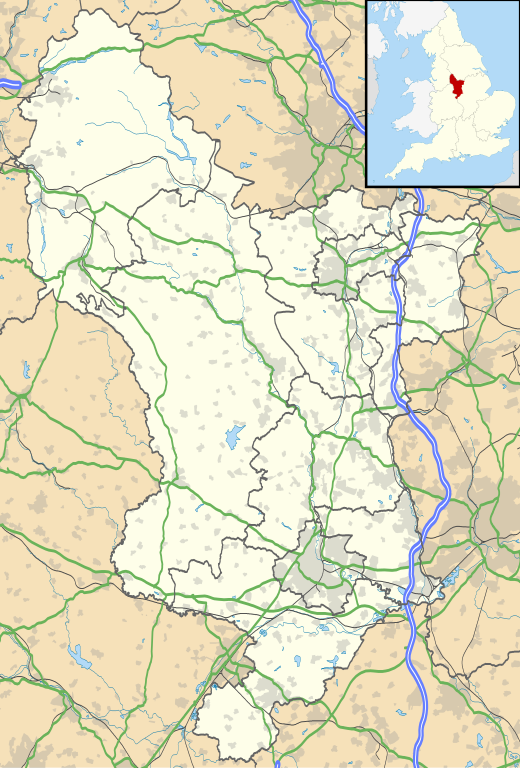
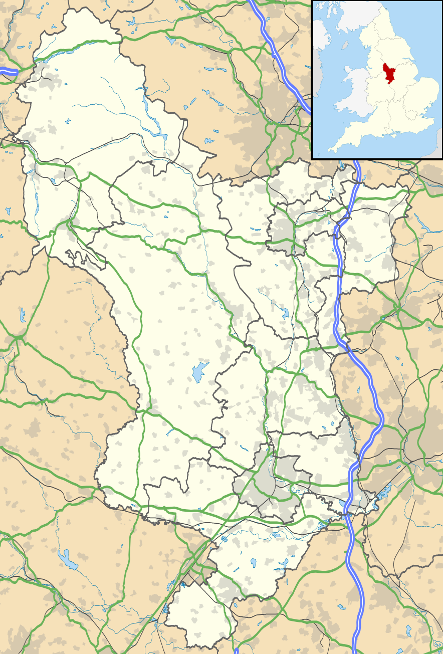
Equirectangular map projection on WGS 84 datum, with N/S stretched 165%
1168:
1128:
1123:
1078:
1068:
988:
958:
953:
943:
908:
813:
778:
763:
713:
652:
1118:
1058:
998:
968:
823:
818:
683:
206:
Administrative borders and coastline data from
Boundary-Line product.
1333:
1038:
1033:
1028:
933:
853:
798:
748:
723:
688:
673:
601:
Click on a date/time to view the file as it appeared at that time.
1353:
282:
Contains
Ordnance Survey data © Crown copyright and database right
1103:
1083:
993:
903:
858:
848:
788:
1413:
1048:
918:
743:
708:
1348:
1303:
913:
838:
793:
82:(SVG file, nominally 884 × 1,305 pixels, file size: 2.38 MB)
1358:
1283:
843:
1438:
1288:
185:
88:
1448:
1433:
1408:
1373:
1473:
1468:
1388:
1328:
375:
Add a one-line explanation of what this file represents
1428:
1393:
1318:
1418:
1403:
1383:
1363:
1313:
663:
1463:
1443:
1398:
1368:
1338:
1323:
1308:
1298:
1184:
599:
504:
Creative
Commons Attribution-ShareAlike 3.0 Unported
478:
Creative
Commons Attribution-ShareAlike 3.0 Unported
112:
Commons is a freely licensed media file repository.
1458:
1453:
1343:
1423:
1378:
1273:
209:All other geographic data from Meridian 2 product.
1278:
1264:Πρότυπο:Location map Ηνωμένο Βασίλειο Ντέρμπισαϊρ
1234:Plantilya:Location map United Kingdom Derbyshire
1219:Mòdul:Location map/data/Regne Unit Derbyshire/ús
328:https://creativecommons.org/licenses/by-sa/3.0
93:
1214:Mòdul:Location map/data/Regne Unit Derbyshire
334:Creative Commons Attribution-Share Alike 3.0
252:
237:
181:
130:
1294:Plantilla:Mapa de localización de Derbyshire
1254:Nodyn:Location map United Kingdom Derbyshire
347:
226:
191:
14:
1194:قالب:Location map United Kingdom Derbyshire
294:– to copy, distribute and transmit the work
142:, UK with the following information shown:
41:Size of this PNG preview of this SVG file:
1186:The following other wikis use this file:
352:File:Devon UK district map (blank).svg
124:
275:Attribution-Share Alike 3.0 Unported
233:, created using Ordnance Survey data
592:
263:
258:
13:
1224:Mòdul:Location map/data/Derbyshire
651:{{Information |Description=Map of
380:
374:
249:
125:
75:
1494:
1204:Шаблон:ПК Великобритания Дарбишър
379:
365:
305:Under the following conditions:
270:This file is licensed under the
262:
257:
251:
92:
31:
21:
362:
1181:
596:
361:
133:Derbyshire UK location map.svg
26:
1:
162:Geographic limitation :
152:Roads and railway station are
809:Derby Museum and Art Gallery
660:
395:Items portrayed in this file
7:
1230:Usage on ceb.wikipedia.org
149:Coastline, lakes and rivers
10:
1499:
1270:Usage on es.wikipedia.org
1260:Usage on el.wikipedia.org
1250:Usage on cy.wikipedia.org
1240:Usage on cs.wikipedia.org
1210:Usage on ca.wikipedia.org
1200:Usage on bg.wikipedia.org
1190:Usage on ar.wikipedia.org
319:same or compatible license
127:
1244:Šablona:LocMap Derbyshire
593:
16:
784:Chesterfield, Derbyshire
719:Black Rocks (Derbyshire)
629:18:46, 26 September 2010
364:
285:
214:England location map.svg
99:This is a file from the
36:
650:
184:
103:. Information from its
1334:Ashbourne (Derbyshire)
1164:Willington, Derbyshire
899:Hartshorne, Derbyshire
894:Hartington, Derbyshire
704:Barrow Hill Roundhouse
146:Administrative borders
106:description page there
1354:Creswell (Derbyshire)
1114:Thornhill, Derbyshire
984:Melbourne, Derbyshire
834:Eckington, Derbyshire
759:Castleton, Derbyshire
694:Ashbourne, Derbyshire
1159:Whitwell, Derbyshire
1089:Staveley, Derbyshire
1004:Newhaven, Derbyshire
884:Hadfield, Derbyshire
829:Duffield, Derbyshire
65:1,387 × 2,048 pixels
1414:Hatton (Derbyshire)
974:Matlock, Derbyshire
300:– to adapt the work
212:Inset derived from
47:Other resolutions:
1134:Treak Cliff Cavern
1054:Ripley, Derbyshire
924:Heatherton Village
69:884 × 1,305 pixels
61:693 × 1,024 pixels
1483:more global usage
1349:Coton in the Elms
1182:Global file usage
658:
543:26 September 2010
488:copyright license
474:copyright license
373:
358:
357:
246:
243:Reusing this file
186:26 September 2010
121:
120:
101:Wikimedia Commons
32:Global file usage
1490:
1304:Chatsworth House
1009:Normanton, Derby
964:Mackworth, Derby
949:Leam, Derbyshire
929:Hope, Derbyshire
774:Chatsworth House
641:
603:
444:copyright status
430:copyright status
371:
341:
338:
335:
332:
329:
321:as the original.
283:
272:Creative Commons
266:
265:
261:
260:
255:
254:
240:
187:
134:
128:
117:
96:
95:
89:
83:
72:
57:520 × 768 pixels
53:325 × 480 pixels
49:162 × 240 pixels
43:406 × 599 pixels
1498:
1497:
1493:
1492:
1491:
1489:
1488:
1487:
1180:
1139:Tunstead Milton
1074:South Wingfield
1019:Osmaston, Derby
729:Bolsover Castle
679:Allenton, Derby
659:
647:
639:
595:
594:
591:
590:
589:
588:
587:
586:
585:
584:
582:
572:
571:
570:
568:
553:
552:
551:
550:
549:
548:
547:
546:
544:
534:
533:
532:
530:
515:
514:
513:
512:
511:
510:
509:
508:
506:
494:
493:
492:
490:
471:
470:
469:
468:
467:
466:
465:
464:
462:
450:
449:
448:
446:
427:
426:
425:
424:
423:
422:
421:
420:
418:
406:
405:
404:
402:
378:
377:
376:
359:
343:
342:
339:
336:
333:
330:
327:
326:
284:
281:
278:
267:
197:Ordnance Survey
132:
123:
122:
111:
110:
109:is shown below.
85:
81:
74:
73:
46:
12:
11:
5:
1496:
1485:of this file.
1479:
1478:
1477:
1476:
1471:
1466:
1461:
1456:
1451:
1446:
1441:
1436:
1431:
1426:
1421:
1416:
1411:
1406:
1401:
1396:
1391:
1386:
1381:
1376:
1371:
1366:
1361:
1359:Aston-on-Trent
1356:
1351:
1346:
1341:
1336:
1331:
1326:
1321:
1316:
1311:
1306:
1301:
1296:
1291:
1286:
1284:Creswell Crags
1281:
1276:
1268:
1267:
1266:
1258:
1257:
1256:
1248:
1247:
1246:
1238:
1237:
1236:
1228:
1227:
1226:
1221:
1216:
1208:
1207:
1206:
1198:
1197:
1196:
1183:
1178:to this file.
1172:
1171:
1166:
1161:
1156:
1151:
1146:
1141:
1136:
1131:
1126:
1121:
1116:
1111:
1106:
1101:
1096:
1091:
1086:
1081:
1076:
1071:
1066:
1061:
1056:
1051:
1046:
1041:
1036:
1031:
1026:
1021:
1016:
1014:Oakwood, Derby
1011:
1006:
1001:
996:
991:
986:
981:
976:
971:
966:
961:
956:
951:
946:
941:
939:Kedleston Hall
936:
931:
926:
921:
916:
911:
906:
901:
896:
891:
886:
881:
876:
871:
869:Greenhill Lane
866:
861:
856:
851:
846:
841:
836:
831:
826:
821:
816:
811:
806:
801:
796:
791:
786:
781:
776:
771:
766:
761:
756:
751:
746:
741:
736:
731:
726:
721:
716:
711:
706:
701:
699:Aston-on-Trent
696:
691:
686:
681:
676:
669:is available.
662:
657:
656:
649:
645:
642:
636:
631:
626:
622:
621:
618:
615:
612:
609:
606:
598:
583:
580:
578:
577:
576:
574:
573:
569:
564:
562:
561:
560:
559:
557:
545:
542:
540:
539:
538:
536:
535:
531:
526:
524:
523:
522:
521:
519:
507:
502:
500:
499:
498:
496:
495:
491:
486:
484:
483:
482:
481:
479:
475:
463:
458:
456:
455:
454:
452:
451:
447:
442:
440:
439:
438:
437:
435:
431:
419:
414:
412:
411:
410:
408:
407:
403:
398:
396:
393:
392:
391:
390:
388:
384:
370:
369:
366:
363:
356:
355:
349:
348:Other versions
345:
344:
325:
324:
323:
322:
312:
303:
302:
301:
295:
288:You are free:
279:
269:
268:
250:
247:
235:
234:
228:
224:
223:
222:
221:
210:
207:
193:
189:
188:
183:
179:
178:
177:
176:
173:
170:
167:
157:
156:
153:
150:
147:
135:
126:
119:
118:
97:
87:
86:
40:
35:
34:
29:
24:
19:
9:
6:
4:
3:
2:
1495:
1486:
1484:
1475:
1472:
1470:
1467:
1465:
1462:
1460:
1457:
1455:
1452:
1450:
1447:
1445:
1442:
1440:
1439:Denby Bottles
1437:
1435:
1432:
1430:
1427:
1425:
1422:
1420:
1417:
1415:
1412:
1410:
1407:
1405:
1402:
1400:
1397:
1395:
1392:
1390:
1387:
1385:
1382:
1380:
1377:
1375:
1372:
1370:
1367:
1365:
1362:
1360:
1357:
1355:
1352:
1350:
1347:
1345:
1342:
1340:
1337:
1335:
1332:
1330:
1327:
1325:
1322:
1320:
1317:
1315:
1312:
1310:
1307:
1305:
1302:
1300:
1297:
1295:
1292:
1290:
1287:
1285:
1282:
1280:
1277:
1275:
1272:
1271:
1269:
1265:
1262:
1261:
1259:
1255:
1252:
1251:
1249:
1245:
1242:
1241:
1239:
1235:
1232:
1231:
1229:
1225:
1222:
1220:
1217:
1215:
1212:
1211:
1209:
1205:
1202:
1201:
1199:
1195:
1192:
1191:
1189:
1188:
1187:
1179:
1177:
1170:
1167:
1165:
1162:
1160:
1157:
1155:
1154:Whatstandwell
1152:
1150:
1149:Whaley Bridge
1147:
1145:
1142:
1140:
1137:
1135:
1132:
1130:
1127:
1125:
1122:
1120:
1117:
1115:
1112:
1110:
1107:
1105:
1102:
1100:
1097:
1095:
1092:
1090:
1087:
1085:
1082:
1080:
1077:
1075:
1072:
1070:
1067:
1065:
1062:
1060:
1057:
1055:
1052:
1050:
1047:
1045:
1044:Renishaw Hall
1042:
1040:
1037:
1035:
1032:
1030:
1027:
1025:
1022:
1020:
1017:
1015:
1012:
1010:
1007:
1005:
1002:
1000:
997:
995:
992:
990:
987:
985:
982:
980:
977:
975:
972:
970:
967:
965:
962:
960:
957:
955:
952:
950:
947:
945:
942:
940:
937:
935:
932:
930:
927:
925:
922:
920:
917:
915:
912:
910:
907:
905:
902:
900:
897:
895:
892:
890:
889:Hardwick Hall
887:
885:
882:
880:
877:
875:
872:
870:
867:
865:
864:Great Hucklow
862:
860:
857:
855:
852:
850:
847:
845:
842:
840:
837:
835:
832:
830:
827:
825:
822:
820:
817:
815:
812:
810:
807:
805:
802:
800:
797:
795:
792:
790:
787:
785:
782:
780:
777:
775:
772:
770:
769:Chapel Milton
767:
765:
762:
760:
757:
755:
752:
750:
747:
745:
742:
740:
737:
735:
732:
730:
727:
725:
722:
720:
717:
715:
712:
710:
707:
705:
702:
700:
697:
695:
692:
690:
687:
685:
682:
680:
677:
675:
672:
671:
670:
668:
654:
648:
643:
637:
635:
632:
630:
627:
624:
623:
619:
616:
613:
610:
607:
605:
604:
602:
581:image/svg+xml
579:
567:
563:
541:
529:
525:
505:
501:
489:
485:
461:
457:
445:
441:
417:
413:
401:
397:
394:
367:
360:
353:
350:
346:
331:CC BY-SA 3.0
320:
316:
313:
310:
307:
306:
304:
299:
296:
293:
290:
289:
287:
286:
280:Attribution:
276:
273:
256:
248:
244:
239:
236:
232:
229:
225:
219:
215:
211:
208:
205:
204:
203:
201:
198:
194:
190:
180:
175:South: 52.69N
174:
172:North: 53.55N
171:
168:
165:
164:
163:
160:
154:
151:
148:
145:
144:
143:
141:
136:
129:
115:
108:
107:
102:
98:
91:
90:
84:
79:
78:Original file
70:
66:
62:
58:
54:
50:
44:
39:
33:
30:
28:
25:
23:
20:
18:
15:
1480:
1289:Chesterfield
1185:
1173:
1109:Tapton House
1094:Sudbury Hall
1064:Shelton Lock
979:Matlock Bath
664:
638:884 × 1,305
600:
597:File history
314:
308:
297:
291:
195:
161:
158:
137:
114:You can help
104:
76:
22:File history
1449:Barrow Hill
1434:Darley Dale
1409:Grindleford
1374:Barlborough
1144:West Hallam
1099:Swadlincote
1024:Peak Forest
879:Haddon Hall
874:Grindleford
804:Darley Dale
754:Calke Abbey
739:Bretby Hall
734:Brassington
460:copyrighted
434:copyrighted
354:- Blank map
315:share alike
309:attribution
169:East: 1.10W
166:West: 2.06W
155:Urban areas
131:Description
1474:Duckmanton
1469:Dove Holes
1389:Hathersage
1329:Clay Cross
1176:more links
1169:Wirksworth
1129:Tissington
1124:Tintwistle
1079:Sparrowpit
1069:Shirebrook
989:Mickleover
959:Long Eaton
954:Littleover
944:Killamarsh
909:Hathersage
814:Derbyshire
779:Chellaston
764:Chaddesden
714:Birchinlee
661:File usage
653:Derbyshire
614:Dimensions
566:media type
556:media type
416:Derbyshire
387:Derbyshire
238:Permission
140:Derbyshire
27:File usage
1429:Cutthorpe
1394:Grassmoor
1319:Ambergate
1119:Tideswell
1059:Sandiacre
999:New Mills
969:Markeaton
824:Dronfield
819:Doveridge
684:Allestree
667:full list
646:Nilfanion
640:(2.38 MB)
611:Thumbnail
608:Date/Time
528:inception
518:inception
231:Nilfanion
1419:Hayfield
1404:Glapwell
1384:Cromford
1364:Bakewell
1314:Alfreton
1039:Pleasley
1034:Pilsbury
1029:Pentrich
934:Ilkeston
854:Gamesley
799:Cromford
749:Buxworth
724:Bolsover
689:Alvaston
674:Alfreton
368:Captions
298:to remix
292:to share
277:license.
218:Spischot
200:OpenData
1464:Bonsall
1444:Doe Lea
1399:Glossop
1369:Bamford
1339:Ashover
1324:Chinley
1309:Matlock
1299:Wardlow
1104:Tansley
1084:Spondon
994:Monyash
904:Hasland
859:Glossop
849:Findern
789:Chinley
625:current
620:Comment
400:depicts
383:depicts
372:English
138:Map of
80:
1459:Belper
1454:Baslow
1344:Clowne
1049:Repton
919:Heanor
744:Buxton
709:Baslow
227:Author
192:Source
1481:View
1424:Heage
1379:Crich
1274:Derby
1174:View
914:Heage
839:Edale
794:Crich
1279:Eyam
844:Eyam
617:User
340:true
337:true
182:Date
17:File
216:by
202:.
67:|
63:|
59:|
55:|
51:|
45:.
245:)
241:(
220:.
116:.
71:.

.svg)