593:"}},"text\/plain":{"en":{"":"coordinates of the point of view"}}},"{\"value\":{\"latitude\":31.4,\"longitude\":35,\"altitude\":null,\"precision\":1.0e-6,\"globe\":\"http:\\\/\\\/www.wikidata.org\\\/entity\\\/Q2\"},\"type\":\"globecoordinate\"}":{"text\/html":{"en":{"P1259":"31\u00b024'0.000"N, 35\u00b00'0.000"E"}},"text\/plain":{"en":{"P1259":"31\u00b024'0.000\"N, 35\u00b00'0.000\"E"}}}}": -->
555:"}},"text\/plain":{"en":{"":"inception"}}},"{\"value\":{\"time\":\"+2011-11-29T00:00:00Z\",\"timezone\":0,\"before\":0,\"after\":0,\"precision\":11,\"calendarmodel\":\"http:\\\/\\\/www.wikidata.org\\\/entity\\\/Q1985727\"},\"type\":\"time\"}":{"text\/html":{"en":{"P571":"29 November 2011"}},"text\/plain":{"en":{"P571":"29 November 2011"}}}}": -->
43:
337:
150:
164:
343:
348:
95:
511:"}},"text\/plain":{"en":{"":"copyright license"}}},"{\"value\":{\"entity-type\":\"item\",\"numeric-id\":14946043,\"id\":\"Q14946043\"},\"type\":\"wikibase-entityid\"}":{"text\/html":{"en":{"P275":"
467:"}},"text\/plain":{"en":{"":"copyright status"}}},"{\"value\":{\"entity-type\":\"item\",\"numeric-id\":50423863,\"id\":\"Q50423863\"},\"type\":\"wikibase-entityid\"}":{"text\/html":{"en":{"P6216":"
589:
389:– You must give appropriate credit, provide a link to the license, and indicate if changes were made. You may do so in any reasonable manner, but not in any way that suggests the licensor endorses you or your use.
141:
147:
512:
468:
590:
464:
552:
508:
61:
57:
53:
47:
106:
515:"}},"text\/plain":{"en":{"P275":"Creative Commons Attribution-ShareAlike 3.0 Unported"}}}}": -->
74:
538:
494:
157:
765:
This file contains additional information, probably added from the digital camera or scanner used to create or digitize it.
396:
600:
478:
562:
522:
453:
358:
293:
768:
If the file has been modified from its original state, some details may not fully reflect the modified file.
801:
395:– If you remix, transform, or build upon the material, you must distribute your contributions under the
709:
471:"}},"text\/plain":{"en":{"P6216":"copyrighted"}}}}": -->
695:
The following pages on the
English Knowledge use this file (pages on other projects are not listed):
668:
663:
65:
42:
699:
114:
704:
355:
316:
8:
752:
679:
320:
297:
163:
101:
443:
610:
572:
532:
488:
216:
816:
312:
747:
192:
737:
636:
Click on a date/time to view the file as it appeared at that time.
727:
204:
149:
142:
31° 24′ 00″ N, 35° 00′ 00″ E
262:
89:
437:
Add a one-line explanation of what this file represents
223:
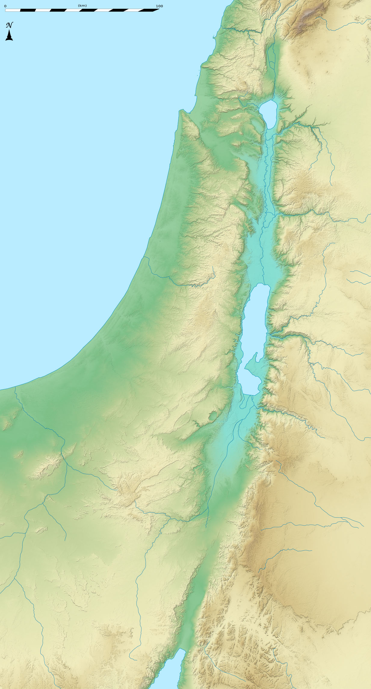
Equirectangular projection, N/S stretching 115 %.
693:
79:(1,233 × 2,291 pixels, file size: 743 KB, MIME type:
718:
634:
539:
Creative
Commons Attribution-ShareAlike 3.0 Unported
513:
Creative
Commons Attribution-ShareAlike 3.0 Unported
113:
Commons is a freely licensed media file repository.
406:https://creativecommons.org/licenses/by-sa/3.0
94:
412:Creative Commons Attribution-Share Alike 3.0
336:
258:
178:
307:
268:
14:
753:Formula:Charta locatrix Israelis physicalis
372:– to copy, distribute and transmit the work
234:Bathymetry: 1:3,724,000 (precision: 931 m)
230:Topography: 1:1,608,000 (precision: 402 m)
215:Carte physique vierge (sans frontières) d'
720:The following other wikis use this file:
845:xmp.did:31BD35ED0B1AE111829C90BFEA124D8B
156:View this and other nearby images on:
125:
359:Attribution-Share Alike 3.0 Unported
273:Topographic background map: Own work
132:
627:
347:
342:
13:
763:
442:
436:
333:
209:
197:
185:
126:
72:
857:
770:
441:
181:Dead Sea terrain location map.jpg
694:
601:coordinates of the point of view
591:coordinates of the point of view
427:
383:Under the following conditions:
354:This file is licensed under the
346:
341:
335:
219:, destinée à la géolocalisation.
162:
148:
93:
31:
21:
834:Date metadata was last modified
424:
292:All additional data taken from
198:
842:Unique ID of original document
715:
631:
423:
239:Geographic limits of the map:
210:
186:
26:
1:
36:
690:
449:Items portrayed in this file
329:
294:File:Israel_location_map.svg
7:
826:Date and time of digitizing
802:Adobe Photoshop CS5 Windows
760:
616:31°24'0.000"N, 35°0'0.000"E
10:
862:
744:Usage on la.wikipedia.org
734:Usage on id.wikipedia.org
724:Usage on fr.wikipedia.org
397:same or compatible license
286:NASA SRTM3 (public domain)
175:
128:
808:File change date and time
748:Usor:Andrew Dalby/Chartae
710:Talk:Jerusalem/Archive 15
628:
16:
426:
363:
100:This is a file from the
41:
837:01:57, 29 November 2011
829:01:57, 29 November 2011
811:23:57, 28 November 2011
738:Gempa bumi Yerikho 1927
700:1927 Jericho earthquake
685:
664:22:23, 28 November 2011
300:under GFDL/CC-BY-SA 3.0
261:
104:. Information from its
705:749 Galilee earthquake
203:Blank location map of
168:31.400000; 35.000000
107:description page there
46:Size of this preview:
782:Horizontal resolution
728:Canal de la mer Morte
66:1,233 × 2,291 pixels
790:Vertical resolution
378:– to adapt the work
191:Positionskarte von
52:Other resolutions:
849:
848:
716:Global file usage
688:
523:copyright license
509:copyright license
435:
326:
325:
173:
172:
122:
121:
102:Wikimedia Commons
32:Global file usage
853:
771:
676:
638:
578:29 November 2011
479:copyright status
465:copyright status
433:
419:
416:
413:
410:
407:
399:as the original.
356:Creative Commons
350:
349:
345:
344:
339:
338:
278:Sources of data:
264:
263:29 November 2011
214:
212:Français :
207:(no boundaries).
202:
190:
182:
176:
169:
166:
152:
151:
145:
144:
133:
118:
97:
96:
90:
84:
82:
69:
62:413 × 768 pixels
58:258 × 480 pixels
54:129 × 240 pixels
48:322 × 598 pixels
861:
860:
856:
855:
854:
852:
851:
850:
759:
714:
696:
689:
682:
674:
630:
629:
626:
625:
624:
623:
622:
621:
620:
619:
617:
607:
606:
605:
603:
588:
587:
586:
585:
584:
583:
582:
581:
579:
569:
568:
567:
565:
550:
549:
548:
547:
546:
545:
544:
543:
541:
529:
528:
527:
525:
506:
505:
504:
503:
502:
501:
500:
499:
497:
485:
484:
483:
481:
462:
461:
460:
459:
458:
456:
440:
439:
438:
421:
420:
417:
414:
411:
408:
405:
404:
362:
351:
332:
327:
220:
208:
196:
180:
167:
140:
139:
136:Camera location
131:
124:
123:
112:
111:
110:is shown below.
86:
80:
78:
71:
70:
51:
12:
11:
5:
859:
847:
846:
843:
839:
838:
835:
831:
830:
827:
823:
822:
819:
813:
812:
809:
805:
804:
799:
795:
794:
791:
787:
786:
783:
779:
778:
775:
762:
758:
757:
756:
755:
750:
742:
741:
740:
732:
731:
730:
717:
713:
712:
707:
702:
692:
687:
686:
684:
680:
677:
673:1,233 × 2,291
671:
666:
661:
657:
656:
653:
650:
647:
644:
641:
633:
618:
615:
613:
612:
611:
609:
608:
604:
599:
597:
596:
595:
594:
592:
580:
577:
575:
574:
573:
571:
570:
566:
561:
559:
558:
557:
556:
554:
542:
537:
535:
534:
533:
531:
530:
526:
521:
519:
518:
517:
516:
514:
510:
498:
493:
491:
490:
489:
487:
486:
482:
477:
475:
474:
473:
472:
470:
466:
457:
452:
450:
447:
446:
445:
444:
432:
431:
428:
425:
403:
402:
401:
400:
390:
381:
380:
379:
373:
366:You are free:
353:
352:
334:
331:
328:
324:
323:
309:
305:
304:
303:
302:
290:
289:
288:
284:
270:
266:
265:
260:
256:
255:
254:
253:
250:
247:
244:
237:
236:
232:
183:
174:
171:
170:
160:
154:
137:
130:
127:
120:
119:
98:
88:
87:
45:
40:
39:
34:
29:
24:
19:
9:
6:
4:
3:
2:
858:
844:
841:
840:
836:
833:
832:
828:
825:
824:
820:
818:
815:
814:
810:
807:
806:
803:
800:
798:Software used
797:
796:
792:
789:
788:
784:
781:
780:
776:
773:
772:
769:
766:
754:
751:
749:
746:
745:
743:
739:
736:
735:
733:
729:
726:
725:
723:
722:
721:
711:
708:
706:
703:
701:
698:
697:
683:
681:MichaelNetzer
678:
672:
670:
667:
665:
662:
659:
658:
654:
651:
648:
645:
642:
640:
639:
637:
614:
602:
598:
576:
564:
560:
540:
536:
524:
520:
496:
492:
480:
476:
455:
451:
448:
429:
422:
409:CC BY-SA 3.0
398:
394:
391:
388:
385:
384:
382:
377:
374:
371:
368:
367:
365:
364:
360:
357:
340:
322:
318:
314:
310:
306:
301:
299:
295:
291:
287:
285:
283:
281:
280:
279:
277:
276:
275:
274:
271:
267:
257:
251:
248:
245:
242:
241:
240:
235:
233:
231:
229:
228:
227:
226:
224:
221:
218:
213:
206:
201:
194:
189:
184:
177:
165:
161:
159:
158:OpenStreetMap
155:
153:
143:
138:
135:
134:
116:
109:
108:
103:
99:
92:
91:
85:
76:
75:Original file
67:
63:
59:
55:
49:
44:
38:
35:
33:
30:
28:
25:
23:
20:
18:
15:
767:
764:
719:
635:
632:File history
392:
386:
375:
369:
321:NordNordWest
298:NordNordWest
272:
238:
222:
211:
199:
187:
115:You can help
105:
73:
22:File history
817:Color space
774:Orientation
495:copyrighted
469:copyrighted
393:share alike
387:attribution
311:Eric Gaba (
296:created by
282:SRTM30 Plus
179:Description
691:File usage
649:Dimensions
252:E: 36.3° E
249:W: 33.7° E
246:S: 29.3° N
243:N: 33.5° N
81:image/jpeg
27:File usage
646:Thumbnail
643:Date/Time
563:inception
553:inception
330:Licensing
200:English:
188:Deutsch:
761:Metadata
675:(743 KB)
430:Captions
376:to remix
370:to share
361:license.
317:fr:Sting
37:Metadata
660:current
655:Comment
454:depicts
434:English
225:Scales:
129:Summary
77:
793:72 dpi
785:72 dpi
777:Normal
319:) and
308:Author
269:Source
217:Israël
205:Israel
193:Israel
146:
313:Sting
821:sRGB
652:User
418:true
415:true
259:Date
17:File
315:-
64:|
60:|
56:|
50:.
195:.
117:.
83:)
68:.
Text is available under the Creative Commons Attribution-ShareAlike License. Additional terms may apply.