713:"}},"text\/plain":{"en":{"":"coordinates of the point of view"}}},"{\"value\":{\"latitude\":54.45274,\"longitude\":-3.014,\"altitude\":null,\"precision\":1.0e-5,\"globe\":\"http:\\\/\\\/www.wikidata.org\\\/entity\\\/Q2\"},\"type\":\"globecoordinate\"}":{"text\/html":{"en":{"P1259":"54\u00b027'9.86"N, 3\u00b00'50.40"W"}},"text\/plain":{"en":{"P1259":"54\u00b027'9.86\"N, 3\u00b00'50.40\"W"}}},"{\"value\":{\"entity-type\":\"property\",\"numeric-id\":7787,\"id\":\"P7787\"},\"type\":\"wikibase-entityid\"}":{"text\/html":{"en":{"":"
900:"}},"text\/plain":{"en":{"":"coordinates of depicted place"}}},"{\"value\":{\"latitude\":54.4531,\"longitude\":-3.0135,\"altitude\":null,\"precision\":1.0e-5,\"globe\":\"http:\\\/\\\/www.wikidata.org\\\/entity\\\/Q2\"},\"type\":\"globecoordinate\"}":{"text\/html":{"en":{"P9149":"54\u00b027'11.16"N, 3\u00b00'48.60"W"}},"text\/plain":{"en":{"P9149":"54\u00b027'11.16\"N, 3\u00b00'48.60\"W"}}},"{\"value\":{\"entity-type\":\"property\",\"numeric-id\":7787,\"id\":\"P7787\"},\"type\":\"wikibase-entityid\"}":{"text\/html":{"en":{"":"
1006:"}},"text\/plain":{"en":{"":"checksum"}}},"{\"value\":\"033de3b06128982fd7c009bbb1d0606cdac39d26\",\"type\":\"string\"}":{"text\/html":{"en":{"P4092":"033de3b06128982fd7c009bbb1d0606cdac39d26"}},"text\/plain":{"en":{"P4092":"033de3b06128982fd7c009bbb1d0606cdac39d26"}}},"{\"value\":{\"entity-type\":\"property\",\"numeric-id\":459,\"id\":\"P459\"},\"type\":\"wikibase-entityid\"}":{"text\/html":{"en":{"":"
484:"}},"text\/plain":{"en":{"":"author name string"}}},"{\"value\":\"Gordon Brown\",\"type\":\"string\"}":{"text\/html":{"en":{"P2093":"Gordon Brown"}},"text\/plain":{"en":{"P2093":"Gordon Brown"}}},"{\"value\":{\"entity-type\":\"property\",\"numeric-id\":2699,\"id\":\"P2699\"},\"type\":\"wikibase-entityid\"}":{"text\/html":{"en":{"":"
675:"}},"text\/plain":{"en":{"":"inception"}}},"{\"value\":{\"time\":\"+2010-03-21T00:00:00Z\",\"timezone\":0,\"before\":0,\"after\":0,\"precision\":11,\"calendarmodel\":\"http:\\\/\\\/www.wikidata.org\\\/entity\\\/Q1985727\"},\"type\":\"time\"}":{"text\/html":{"en":{"P571":"21 March 2010"}},"text\/plain":{"en":{"P571":"21 March 2010"}}}}": -->
777:
277:
227:
1002:
219:
291:
241:
312:
350:
355:
67:
492:"}},"text\/plain":{"en":{"P2699":"https:\/\/www.geograph.org.uk\/profile\/1876"}}},"{\"value\":{\"entity-type\":\"property\",\"numeric-id\":3831,\"id\":\"P3831\"},\"type\":\"wikibase-entityid\"}":{"text\/html":{"en":{"":"
785:"}},"text\/plain":{"en":{"P7482":"file available on the internet"}}},"{\"value\":{\"entity-type\":\"property\",\"numeric-id\":137,\"id\":\"P137\"},\"type\":\"wikibase-entityid\"}":{"text\/html":{"en":{"":"
793:"}},"text\/plain":{"en":{"P137":"Geograph Britain and Ireland"}}},"{\"value\":{\"entity-type\":\"property\",\"numeric-id\":7384,\"id\":\"P7384\"},\"type\":\"wikibase-entityid\"}":{"text\/html":{"en":{"":"
496:"}},"text\/plain":{"en":{"":"object of statement has role"}}},"{\"value\":{\"entity-type\":\"item\",\"numeric-id\":33231,\"id\":\"Q33231\"},\"type\":\"wikibase-entityid\"}":{"text\/html":{"en":{"P3831":"
1010:"}},"text\/plain":{"en":{"":"determination method"}}},"{\"value\":{\"entity-type\":\"item\",\"numeric-id\":13414952,\"id\":\"Q13414952\"},\"type\":\"wikibase-entityid\"}":{"text\/html":{"en":{"P459":"
968:"}},"text\/plain":{"en":{"":"media type"}}},"{\"value\":\"image\\\/jpeg\",\"type\":\"string\"}":{"text\/html":{"en":{"P1163":"image\/jpeg"}},"text\/plain":{"en":{"P1163":"image\/jpeg"}}}}": -->
631:"}},"text\/plain":{"en":{"":"copyright license"}}},"{\"value\":{\"entity-type\":\"item\",\"numeric-id\":19068220,\"id\":\"Q19068220\"},\"type\":\"wikibase-entityid\"}":{"text\/html":{"en":{"P275":"
587:"}},"text\/plain":{"en":{"":"copyright status"}}},"{\"value\":{\"entity-type\":\"item\",\"numeric-id\":50423863,\"id\":\"Q50423863\"},\"type\":\"wikibase-entityid\"}":{"text\/html":{"en":{"P6216":"
781:"}},"text\/plain":{"en":{"":"source of file"}}},"{\"value\":{\"entity-type\":\"item\",\"numeric-id\":74228490,\"id\":\"Q74228490\"},\"type\":\"wikibase-entityid\"}":{"text\/html":{"en":{"P7482":"
1073:"}},"text\/plain":{"en":{"":"data size"}}},"{\"value\":{\"amount\":\"+144583\",\"unit\":\"http:\\\/\\\/www.wikidata.org\\\/entity\\\/Q8799\"},\"type\":\"quantity\"}":{"text\/html":{"en":{"P3575":"144,583
1246:
1118:"}},"text\/plain":{"en":{"":"height"}}},"{\"value\":{\"amount\":\"+480\",\"unit\":\"http:\\\/\\\/www.wikidata.org\\\/entity\\\/Q355198\"},\"type\":\"quantity\"}":{"text\/html":{"en":{"P2048":"480
789:"}},"text\/plain":{"en":{"":"operator"}}},"{\"value\":{\"entity-type\":\"item\",\"numeric-id\":1503119,\"id\":\"Q1503119\"},\"type\":\"wikibase-entityid\"}":{"text\/html":{"en":{"P137":"
1163:"}},"text\/plain":{"en":{"":"width"}}},"{\"value\":{\"amount\":\"+640\",\"unit\":\"http:\\\/\\\/www.wikidata.org\\\/entity\\\/Q355198\"},\"type\":\"quantity\"}":{"text\/html":{"en":{"P2049":"640
904:"}},"text\/plain":{"en":{"":"heading"}}},"{\"value\":{\"amount\":\"+45\",\"unit\":\"http:\\\/\\\/www.wikidata.org\\\/entity\\\/Q28390\"},\"type\":\"quantity\"}":{"text\/html":{"en":{"P7787":"45
717:"}},"text\/plain":{"en":{"":"heading"}}},"{\"value\":{\"amount\":\"+45\",\"unit\":\"http:\\\/\\\/www.wikidata.org\\\/entity\\\/Q28390\"},\"type\":\"quantity\"}":{"text\/html":{"en":{"P7787":"45
801:"}},"text\/plain":{"en":{"P7384":"1767270"}}},"{\"value\":{\"entity-type\":\"property\",\"numeric-id\":973,\"id\":\"P973\"},\"type\":\"wikibase-entityid\"}":{"text\/html":{"en":{"":"
480:"}},"text\/plain":{"en":{"":"creator"}}},"{\"value\":{\"entity-type\":\"property\",\"numeric-id\":2093,\"id\":\"P2093\"},\"type\":\"wikibase-entityid\"}":{"text\/html":{"en":{"":"
1159:
260:
1263:== {{int:filedesc}} == {{Information |description={{en|1=Coffin Stone at Town End This stone is beside a 'corpse road' along which coffins had to be carried from Ambleside for burial at St Oswald's Church, Grasmere. This stone, along with others along th
797:"}},"text\/plain":{"en":{"":"geograph.org.uk image ID"}}},"{\"value\":\"1767270\",\"type\":\"string\"}":{"text\/html":{"en":{"P7384":"
210:
121:
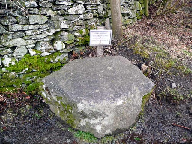
Coffin Stone at Town End This stone is beside a 'corpse road' along which coffins had to be carried from
Ambleside for burial at St Oswald's Church, Grasmere. This stone, along with others along the way, was used to support the coffin while the bearers
402:– You must give appropriate credit, provide a link to the license, and indicate if changes were made. You may do so in any reasonable manner, but not in any way that suggests the licensor endorses you or your use.
274:
224:
78:
46:
798:
1011:
782:
632:
588:
790:
497:
1160:
1115:
1070:
1003:
965:
901:
897:
794:
778:
714:
710:
584:
493:
485:
481:
806:
1007:
802:
786:
672:
628:
489:
477:
1256:
635:"}},"text\/plain":{"en":{"P275":"Creative Commons Attribution-ShareAlike 2.0 Generic"}}}}": -->
809:"}},"text\/plain":{"en":{"P973":"https:\/\/www.geograph.org.uk\/photo\/1767270"}}}}": -->
1055:
832:
658:
614:
284:
234:
852:
319:
1288:
This file contains additional information, probably added from the digital camera or scanner used to create or digitize it.
409:
1245:
1240:
569:
37:
1174:
1129:
1084:
1021:
975:
942:
915:
860:
816:
755:
728:
598:
562:
547:
534:
1048:
875:
845:
682:
642:
507:
466:
365:
1291:
If the file has been modified from its original state, some details may not fully reflect the modified file.
408:– If you remix, transform, or build upon the material, you must distribute your contributions under the
326:
on the
Geograph website for the photographer's contact details. The copyright on this image is owned by
1077:"}},"text\/plain":{"en":{"P3575":"144,583 byte"}}}}": -->
500:"}},"text\/plain":{"en":{"P3831":"photographer"}}}}": -->
591:"}},"text\/plain":{"en":{"P6216":"copyrighted"}}}}": -->
1273:
The following pages on the
English Knowledge use this file (pages on other projects are not listed):
1167:"}},"text\/plain":{"en":{"P2049":"640 pixel"}}}}": -->
1122:"}},"text\/plain":{"en":{"P2048":"480 pixel"}}}}": -->
908:"}},"text\/plain":{"en":{"P7787":"45 degree"}}}}": -->
721:"}},"text\/plain":{"en":{"P7787":"45 degree"}}}}": -->
86:
179:
1014:"}},"text\/plain":{"en":{"P459":"SHA-1"}}}}": -->
882:
867:
554:
362:
163:
8:
306:
290:
240:
331:
73:
456:
142:
152:
1184:
1139:
1094:
1031:
985:
925:
826:
738:
692:
652:
608:
517:
1277:
311:
323:
1213:
Click on a date/time to view the file as it appeared at that time.
276:
226:
261:
54° 27′ 11″ N, 3° 00′ 49″ W
211:
54° 27′ 10″ N, 3° 00′ 50″ W
131:
61:
111:
Coffin Stone at Town End - geograph.org.uk - 1767270.jpg
47:
Coffin_Stone_at_Town_End_-_geograph.org.uk_-_1767270.jpg
450:
Add a one-line explanation of what this file represents
1271:
1211:
85:
Commons is a freely licensed media file repository.
659:
Creative
Commons Attribution-ShareAlike 2.0 Generic
633:
Creative
Commons Attribution-ShareAlike 2.0 Generic
51:(640 × 480 pixels, file size: 141 KB, MIME type:
419:https://creativecommons.org/licenses/by-sa/2.0
66:
807:https:\/\/www.geograph.org.uk\/photo\/1767270
425:Creative Commons Attribution-Share Alike 2.0
343:
127:
108:
490:https:\/\/www.geograph.org.uk\/profile\/1876
148:
137:
14:
1164:
1119:
1074:
905:
718:
385:– to copy, distribute and transmit the work
883:https://www.geograph.org.uk/photo/1767270
1037:033de3b06128982fd7c009bbb1d0606cdac39d26
555:https://www.geograph.org.uk/profile/1876
283:View this and other nearby images on:
233:View this and other nearby images on:
186:
97:
330:and is licensed for reuse under the
251:
201:
1204:
366:Attribution-Share Alike 2.0 Generic
354:
349:
334:Attribution-ShareAlike 2.0 license.
13:
1286:
455:
449:
340:
317:
115:
98:
44:
1312:
1293:
454:
1272:
729:coordinates of the point of view
711:coordinates of the point of view
440:
396:Under the following conditions:
361:This file is licensed under the
353:
348:
342:
310:
289:
275:
267:
239:
225:
217:
65:
21:
437:
116:
41:No higher resolution available.
1208:
833:file available on the internet
783:file available on the internet
436:
318:This image was taken from the
26:
1:
916:coordinates of depicted place
898:coordinates of depicted place
31:
1268:
853:Geograph Britain and Ireland
791:Geograph Britain and Ireland
563:object of statement has role
494:object of statement has role
462:Items portrayed in this file
302:
7:
1283:
266:
216:
10:
1317:
931:54°27'11.16"N, 3°0'48.60"W
410:same or compatible license
105:
100:
1205:
744:54°27'9.86"N, 3°0'50.40"W
192:Gordon Brown /
173:Gordon Brown /
16:
861:geograph.org.uk image ID
795:geograph.org.uk image ID
439:
376:
194:Coffin Stone at Town End
175:Coffin Stone at Town End
72:This is a file from the
36:
1262:
164:required by the license
130:
76:. Information from its
324:this photograph's page
295:54.453100; -3.013500
245:54.452740; -3.014000
79:description page there
1241:20:40, 11 March 2011
1049:determination method
1008:determination method
391:– to adapt the work
535:author name string
482:author name string
1304:
1303:
1266:
1166:
1121:
1076:
907:
720:
643:copyright license
629:copyright license
448:
339:
338:
322:collection. See
300:
299:
250:
249:
199:
198:
167:
94:
93:
74:Wikimedia Commons
1308:
1294:
1253:
1215:
1193:
1148:
1103:
1058:
1053:
953:
952:
947:
885:
880:
876:described at URL
870:
865:
855:
850:
803:described at URL
766:
765:
760:
599:copyright status
585:copyright status
572:
567:
557:
552:
542:
539:
446:
432:
429:
426:
423:
420:
412:as the original.
374:
363:Creative Commons
357:
356:
352:
351:
346:
345:
332:Creative Commons
320:Geograph project
314:
307:
296:
293:
279:
278:
272:
271:
270:
264:
263:
252:
246:
243:
229:
228:
222:
221:
220:
214:
213:
202:
161:
133:
120:
112:
106:
90:
69:
68:
62:
56:
54:
1316:
1315:
1311:
1310:
1309:
1307:
1306:
1305:
1282:
1274:
1267:
1259:
1251:
1207:
1206:
1203:
1202:
1201:
1200:
1199:
1198:
1197:
1196:
1194:
1191:
1181:
1180:
1179:
1177:
1158:
1157:
1156:
1155:
1154:
1153:
1152:
1151:
1149:
1146:
1136:
1135:
1134:
1132:
1113:
1112:
1111:
1110:
1109:
1108:
1107:
1106:
1104:
1101:
1091:
1090:
1089:
1087:
1068:
1067:
1066:
1065:
1064:
1063:
1062:
1061:
1060:
1059:
1054:
1051:
1042:
1041:
1040:
1038:
1028:
1027:
1026:
1024:
1001:
1000:
999:
998:
997:
996:
995:
994:
992:
982:
981:
980:
978:
963:
962:
961:
960:
959:
958:
957:
956:
955:
954:
950:
948:
945:
936:
935:
934:
932:
922:
921:
920:
918:
895:
894:
893:
892:
891:
890:
889:
888:
887:
886:
881:
878:
872:
871:
866:
863:
857:
856:
851:
848:
839:
838:
837:
835:
823:
822:
821:
819:
776:
775:
774:
773:
772:
771:
770:
769:
768:
767:
763:
761:
758:
749:
748:
747:
745:
735:
734:
733:
731:
708:
707:
706:
705:
704:
703:
702:
701:
699:
689:
688:
687:
685:
670:
669:
668:
667:
666:
665:
664:
663:
661:
649:
648:
647:
645:
626:
625:
624:
623:
622:
621:
620:
619:
617:
605:
604:
603:
601:
582:
581:
580:
579:
578:
577:
576:
575:
574:
573:
568:
565:
559:
558:
553:
550:
544:
543:
540:
537:
528:
527:
526:
524:
514:
513:
512:
510:
475:
474:
473:
472:
471:
469:
453:
452:
451:
434:
433:
430:
427:
424:
421:
418:
417:
375:
372:
369:
358:
335:
305:
294:
268:
259:
258:
255:Object location
244:
218:
209:
208:
205:Camera location
200:
189:
182:
170:
143:geograph.org.uk
123:
110:
103:
96:
95:
84:
83:
82:is shown below.
58:
52:
50:
43:
42:
12:
11:
5:
1314:
1302:
1301:
1298:
1285:
1281:
1280:
1270:
1265:
1264:
1261:
1257:
1254:
1248:
1243:
1238:
1234:
1233:
1230:
1227:
1224:
1221:
1218:
1210:
1195:
1189:
1187:
1186:
1185:
1183:
1182:
1178:
1173:
1171:
1170:
1169:
1168:
1162:
1150:
1144:
1142:
1141:
1140:
1138:
1137:
1133:
1128:
1126:
1125:
1124:
1123:
1117:
1105:
1099:
1097:
1096:
1095:
1093:
1092:
1088:
1083:
1081:
1080:
1079:
1078:
1072:
1047:
1046:
1045:
1044:
1043:
1039:
1036:
1034:
1033:
1032:
1030:
1029:
1025:
1020:
1018:
1017:
1016:
1015:
1013:
1009:
1005:
993:
990:
988:
987:
986:
984:
983:
979:
974:
972:
971:
970:
969:
967:
941:
940:
939:
938:
937:
933:
930:
928:
927:
926:
924:
923:
919:
914:
912:
911:
910:
909:
903:
899:
874:
873:
859:
858:
844:
843:
842:
841:
840:
836:
831:
829:
828:
827:
825:
824:
820:
817:source of file
815:
813:
812:
811:
810:
808:
804:
800:
796:
792:
788:
784:
780:
779:source of file
754:
753:
752:
751:
750:
746:
743:
741:
740:
739:
737:
736:
732:
727:
725:
724:
723:
722:
716:
712:
700:
697:
695:
694:
693:
691:
690:
686:
681:
679:
678:
677:
676:
674:
662:
657:
655:
654:
653:
651:
650:
646:
641:
639:
638:
637:
636:
634:
630:
618:
613:
611:
610:
609:
607:
606:
602:
597:
595:
594:
593:
592:
590:
586:
561:
560:
546:
545:
533:
532:
531:
530:
529:
525:
522:
520:
519:
518:
516:
515:
511:
506:
504:
503:
502:
501:
499:
495:
491:
487:
483:
479:
470:
465:
463:
460:
459:
458:
457:
445:
444:
441:
438:
416:
415:
414:
413:
403:
394:
393:
392:
386:
379:You are free:
370:
360:
359:
341:
337:
336:
315:
304:
301:
298:
297:
287:
281:
256:
248:
247:
237:
231:
206:
197:
196:
190:
187:
184:
183:
178:
171:
168:
156:
155:
150:
146:
145:
139:
135:
134:
129:
125:
124:
113:
104:
102:
99:
92:
91:
70:
60:
59:
40:
35:
34:
29:
24:
19:
9:
6:
4:
3:
2:
1313:
1299:
1296:
1295:
1292:
1289:
1279:
1276:
1275:
1260:
1255:
1249:
1247:
1244:
1242:
1239:
1236:
1235:
1231:
1228:
1225:
1222:
1219:
1217:
1216:
1214:
1188:
1176:
1172:
1143:
1131:
1127:
1098:
1086:
1082:
1057:
1050:
1035:
1023:
1019:
989:
977:
973:
944:
929:
917:
913:
884:
877:
869:
862:
854:
847:
834:
830:
818:
814:
757:
742:
730:
726:
698:21 March 2010
696:
684:
680:
660:
656:
644:
640:
616:
612:
600:
596:
571:
564:
556:
549:
536:
521:
509:
505:
468:
464:
461:
442:
435:
422:CC BY-SA 2.0
411:
407:
404:
401:
398:
397:
395:
390:
387:
384:
381:
380:
378:
377:
371:Attribution:
367:
364:
347:
333:
329:
325:
321:
316:
313:
309:
308:
292:
288:
286:
285:OpenStreetMap
282:
280:
262:
257:
254:
253:
242:
238:
236:
235:OpenStreetMap
232:
230:
212:
207:
204:
203:
195:
191:
185:
181:
177: /
176:
172:
165:
160:
158:
157:
154:
151:
147:
144:
140:
136:
132:21 March 2010
126:
119:
114:
107:
88:
81:
80:
75:
71:
64:
63:
57:
48:
39:
33:
30:
28:
25:
23:
20:
18:
15:
1290:
1287:
1212:
1209:File history
570:photographer
541:Gordon Brown
498:photographer
405:
399:
388:
382:
373:Gordon Brown
328:Gordon Brown
327:
265:
215:
193:
180:CC BY-SA 2.0
174:
153:Gordon Brown
117:
87:You can help
77:
45:
22:File history
1278:Corpse road
1258:GeographBot
615:copyrighted
589:copyrighted
406:share alike
400:attribution
159:Attribution
109:Description
1297:_error
1269:File usage
1250:640 × 480
1226:Dimensions
991:image/jpeg
976:media type
966:media type
523:some value
53:image/jpeg
27:File usage
1223:Thumbnail
1220:Date/Time
1085:data size
1071:data size
683:inception
673:inception
303:Licensing
188:InfoField
169:InfoField
118:English:
1284:Metadata
1252:(141 KB)
1100:144,583
1022:checksum
1004:checksum
846:operator
787:operator
443:Captions
389:to remix
383:to share
368:license.
32:Metadata
1237:current
1232:Comment
943:heading
902:heading
868:1767270
799:1767270
756:heading
715:heading
508:creator
478:creator
467:depicts
447:English
122:rested.
101:Summary
49:
1130:height
1116:height
951:degree
906:degree
764:degree
719:degree
273:
223:
149:Author
138:Source
1192:pixel
1175:width
1165:pixel
1161:width
1147:pixel
1120:pixel
1056:SHA-1
1012:SHA-1
141:From
1229:User
1190:640
1145:480
1102:byte
1075:byte
431:true
428:true
128:Date
17:File
949:45
762:45
548:URL
486:URL
1052::
946::
879::
864::
849::
759::
566::
551::
538::
1300:0
166:)
162:(
89:.
55:)
_heading:45.00&language=en)
_heading:45.00&language=en)
