796:"}},"text\/plain":{"en":{"":"coordinates of the point of view"}}},"{\"value\":{\"latitude\":54.74611,\"longitude\":-5.7124,\"altitude\":null,\"precision\":1.0e-5,\"globe\":\"http:\\\/\\\/www.wikidata.org\\\/entity\\\/Q2\"},\"type\":\"globecoordinate\"}":{"text\/html":{"en":{"P1259":"54\u00b044'46.00"N, 5\u00b042'44.64"W"}},"text\/plain":{"en":{"P1259":"54\u00b044'46.00\"N, 5\u00b042'44.64\"W"}}},"{\"value\":{\"entity-type\":\"property\",\"numeric-id\":7787,\"id\":\"P7787\"},\"type\":\"wikibase-entityid\"}":{"text\/html":{"en":{"":"
864:"}},"text\/plain":{"en":{"":"coordinates of depicted place"}}},"{\"value\":{\"latitude\":54.73636,\"longitude\":-5.7055,\"altitude\":null,\"precision\":1.0e-5,\"globe\":\"http:\\\/\\\/www.wikidata.org\\\/entity\\\/Q2\"},\"type\":\"globecoordinate\"}":{"text\/html":{"en":{"P9149":"54\u00b044'10.90"N, 5\u00b042'19.80"W"}},"text\/plain":{"en":{"P9149":"54\u00b044'10.90\"N, 5\u00b042'19.80\"W"}}},"{\"value\":{\"entity-type\":\"property\",\"numeric-id\":7787,\"id\":\"P7787\"},\"type\":\"wikibase-entityid\"}":{"text\/html":{"en":{"":"
1014:"}},"text\/plain":{"en":{"":"checksum"}}},"{\"value\":\"ee8b8185d08f696ba0fbd3879965ff55f0dc401d\",\"type\":\"string\"}":{"text\/html":{"en":{"P4092":"ee8b8185d08f696ba0fbd3879965ff55f0dc401d"}},"text\/plain":{"en":{"P4092":"ee8b8185d08f696ba0fbd3879965ff55f0dc401d"}}},"{\"value\":{\"entity-type\":\"property\",\"numeric-id\":459,\"id\":\"P459\"},\"type\":\"wikibase-entityid\"}":{"text\/html":{"en":{"":"
456:"}},"text\/plain":{"en":{"":"author name string"}}},"{\"value\":\"Aubrey Dale\",\"type\":\"string\"}":{"text\/html":{"en":{"P2093":"Aubrey Dale"}},"text\/plain":{"en":{"P2093":"Aubrey Dale"}}},"{\"value\":{\"entity-type\":\"property\",\"numeric-id\":3831,\"id\":\"P3831\"},\"type\":\"wikibase-entityid\"}":{"text\/html":{"en":{"":"
639:"}},"text\/plain":{"en":{"":"inception"}}},"{\"value\":{\"time\":\"+2006-05-21T00:00:00Z\",\"timezone\":0,\"before\":0,\"after\":0,\"precision\":11,\"calendarmodel\":\"http:\\\/\\\/www.wikidata.org\\\/entity\\\/Q1985727\"},\"type\":\"time\"}":{"text\/html":{"en":{"P571":"21 May 2006"}},"text\/plain":{"en":{"P571":"21 May 2006"}}}}": -->
673:
440:
191:
233:
183:
1010:
205:
276:
314:
319:
72:
452:"}},"text\/plain":{"en":{"P2699":"https:\/\/www.geograph.org.uk\/profile\/5835"}}},"{\"value\":{\"entity-type\":\"property\",\"numeric-id\":2093,\"id\":\"P2093\"},\"type\":\"wikibase-entityid\"}":{"text\/html":{"en":{"":"
681:"}},"text\/plain":{"en":{"P7482":"file available on the internet"}}},"{\"value\":{\"entity-type\":\"property\",\"numeric-id\":137,\"id\":\"P137\"},\"type\":\"wikibase-entityid\"}":{"text\/html":{"en":{"":"
689:"}},"text\/plain":{"en":{"P137":"Geograph Britain and Ireland"}}},"{\"value\":{\"entity-type\":\"property\",\"numeric-id\":7384,\"id\":\"P7384\"},\"type\":\"wikibase-entityid\"}":{"text\/html":{"en":{"":"
460:"}},"text\/plain":{"en":{"":"object of statement has role"}}},"{\"value\":{\"entity-type\":\"item\",\"numeric-id\":33231,\"id\":\"Q33231\"},\"type\":\"wikibase-entityid\"}":{"text\/html":{"en":{"P3831":"
1018:"}},"text\/plain":{"en":{"":"determination method"}}},"{\"value\":{\"entity-type\":\"item\",\"numeric-id\":13414952,\"id\":\"Q13414952\"},\"type\":\"wikibase-entityid\"}":{"text\/html":{"en":{"P459":"
1254:
976:"}},"text\/plain":{"en":{"":"media type"}}},"{\"value\":\"image\\\/jpeg\",\"type\":\"string\"}":{"text\/html":{"en":{"P1163":"image\/jpeg"}},"text\/plain":{"en":{"P1163":"image\/jpeg"}}}}": -->
595:"}},"text\/plain":{"en":{"":"copyright license"}}},"{\"value\":{\"entity-type\":\"item\",\"numeric-id\":19068220,\"id\":\"Q19068220\"},\"type\":\"wikibase-entityid\"}":{"text\/html":{"en":{"P275":"
551:"}},"text\/plain":{"en":{"":"copyright status"}}},"{\"value\":{\"entity-type\":\"item\",\"numeric-id\":50423863,\"id\":\"Q50423863\"},\"type\":\"wikibase-entityid\"}":{"text\/html":{"en":{"P6216":"
677:"}},"text\/plain":{"en":{"":"source of file"}}},"{\"value\":{\"entity-type\":\"item\",\"numeric-id\":74228490,\"id\":\"Q74228490\"},\"type\":\"wikibase-entityid\"}":{"text\/html":{"en":{"P7482":"
1081:"}},"text\/plain":{"en":{"":"data size"}}},"{\"value\":{\"amount\":\"+128619\",\"unit\":\"http:\\\/\\\/www.wikidata.org\\\/entity\\\/Q8799\"},\"type\":\"quantity\"}":{"text\/html":{"en":{"P3575":"128,619
932:"}},"text\/plain":{"en":{"":"captured with"}}},"{\"value\":{\"entity-type\":\"item\",\"numeric-id\":1143323,\"id\":\"Q1143323\"},\"type\":\"wikibase-entityid\"}":{"text\/html":{"en":{"P4082":"
1126:"}},"text\/plain":{"en":{"":"height"}}},"{\"value\":{\"amount\":\"+426\",\"unit\":\"http:\\\/\\\/www.wikidata.org\\\/entity\\\/Q355198\"},\"type\":\"quantity\"}":{"text\/html":{"en":{"P2048":"426
868:"}},"text\/plain":{"en":{"":"heading"}}},"{\"value\":{\"amount\":\"+157\",\"unit\":\"http:\\\/\\\/www.wikidata.org\\\/entity\\\/Q28390\"},\"type\":\"quantity\"}":{"text\/html":{"en":{"P7787":"157
800:"}},"text\/plain":{"en":{"":"heading"}}},"{\"value\":{\"amount\":\"+157\",\"unit\":\"http:\\\/\\\/www.wikidata.org\\\/entity\\\/Q28390\"},\"type\":\"quantity\"}":{"text\/html":{"en":{"P7787":"157
685:"}},"text\/plain":{"en":{"":"operator"}}},"{\"value\":{\"entity-type\":\"item\",\"numeric-id\":1503119,\"id\":\"Q1503119\"},\"type\":\"wikibase-entityid\"}":{"text\/html":{"en":{"P137":"
1171:"}},"text\/plain":{"en":{"":"width"}}},"{\"value\":{\"amount\":\"+640\",\"unit\":\"http:\\\/\\\/www.wikidata.org\\\/entity\\\/Q355198\"},\"type\":\"quantity\"}":{"text\/html":{"en":{"P2049":"640
697:"}},"text\/plain":{"en":{"P7384":"172672"}}},"{\"value\":{\"entity-type\":\"property\",\"numeric-id\":973,\"id\":\"P973\"},\"type\":\"wikibase-entityid\"}":{"text\/html":{"en":{"":"
444:"}},"text\/plain":{"en":{"":"creator"}}},"{\"value\":{\"entity-type\":\"property\",\"numeric-id\":2699,\"id\":\"P2699\"},\"type\":\"wikibase-entityid\"}":{"text\/html":{"en":{"":"
1167:
448:"}},"text\/plain":{"en":{"":"URL"}}},"{\"value\":\"https:\\\/\\\/www.geograph.org.uk\\\/profile\\\/5835\",\"type\":\"string\"}":{"text\/html":{"en":{"P2699":"
224:
174:
693:"}},"text\/plain":{"en":{"":"geograph.org.uk image ID"}}},"{\"value\":\"172672\",\"type\":\"string\"}":{"text\/html":{"en":{"P7384":"
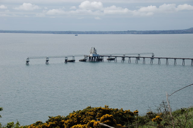
1271:== {{int:filedesc}} == {{Information |description={{en|1=Cloghan jetty, Belfast Lough. Cloghan jetty and the nearby Kilroot power station were planned and built during the early 1970's. The jetty was for use by oil tankers. The great oil crisis caused a
366:– You must give appropriate credit, provide a link to the license, and indicate if changes were made. You may do so in any reasonable manner, but not in any way that suggests the licensor endorses you or your use.
238:
188:
83:
51:
1019:
694:
678:
596:
552:
933:
686:
461:
1168:
1123:
1078:
1011:
973:
929:
865:
861:
797:
793:
690:
674:
548:
457:
453:
445:
1015:
702:
698:
682:
636:
592:
449:
441:
1264:
599:"}},"text\/plain":{"en":{"P275":"Creative Commons Attribution-ShareAlike 2.0 Generic"}}}}": -->
1416:
705:"}},"text\/plain":{"en":{"P973":"https:\/\/www.geograph.org.uk\/photo\/172672"}}}}": -->
1063:
728:
622:
578:
248:
198:
1253:
1248:
42:
959:
748:
283:
1321:
This file contains additional information, probably added from the digital camera or scanner used to create or digitize it.
373:
533:
1182:
1137:
1092:
1029:
983:
943:
906:
879:
838:
811:
756:
712:
562:
526:
513:
498:
1056:
771:
741:
646:
606:
471:
430:
1447:
329:
1324:
If the file has been modified from its original state, some details may not fully reflect the modified file.
372:– If you remix, transform, or build upon the material, you must distribute your contributions under the
290:
on the
Geograph website for the photographer's contact details. The copyright on this image is owned by
1085:"}},"text\/plain":{"en":{"P3575":"128,619 byte"}}}}": -->
464:"}},"text\/plain":{"en":{"P3831":"photographer"}}}}": -->
555:"}},"text\/plain":{"en":{"P6216":"copyrighted"}}}}": -->
1281:
The following pages on the
English Knowledge use this file (pages on other projects are not listed):
872:"}},"text\/plain":{"en":{"P7787":"157 degree"}}}}": -->
804:"}},"text\/plain":{"en":{"P7787":"157 degree"}}}}": -->
1175:"}},"text\/plain":{"en":{"P2049":"640 pixel"}}}}": -->
1130:"}},"text\/plain":{"en":{"P2048":"426 pixel"}}}}": -->
936:"}},"text\/plain":{"en":{"P4082":"Nikon D50"}}}}": -->
91:
1022:"}},"text\/plain":{"en":{"P459":"SHA-1"}}}}": -->
1474:
1290:
778:
763:
505:
326:
8:
1510:
270:
254:
204:
1615:
1333:
295:
78:
420:
1578:
1492:
1350:
1285:
1625:
1588:
1379:
157:
147:
1544:
1192:
1147:
1102:
1039:
993:
953:
889:
821:
722:
656:
616:
572:
481:
275:
1343:
287:
1635:
1360:
1221:
Click on a date/time to view the file as it appeared at that time.
240:
190:
127:
Hunterston on the Clyde. The jetty is now used infrequently.
116:
Cloghan jetty, Belfast Lough - geograph.org.uk - 172672.jpg
52:
Cloghan_jetty,_Belfast_Lough_-_geograph.org.uk_-_172672.jpg
1308:
225:
54° 44′ 11″ N, 5° 42′ 20″ W
175:
54° 44′ 46″ N, 5° 42′ 45″ W
136:
66:
414:
Add a one-line explanation of what this file represents
1279:
1299:
1219:
90:
Commons is a freely licensed media file repository.
623:
Creative
Commons Attribution-ShareAlike 2.0 Generic
597:
Creative
Commons Attribution-ShareAlike 2.0 Generic
56:(640 × 426 pixels, file size: 126 KB, MIME type:
383:https://creativecommons.org/licenses/by-sa/2.0
71:
389:Creative Commons Attribution-Share Alike 2.0
307:
132:
113:
703:https:\/\/www.geograph.org.uk\/photo\/172672
450:https:\/\/www.geograph.org.uk\/profile\/5835
153:
142:
14:
1172:
1127:
1082:
869:
801:
349:– to copy, distribute and transmit the work
1301:The following other wikis use this file:
1045:ee8b8185d08f696ba0fbd3879965ff55f0dc401d
779:https://www.geograph.org.uk/photo/172672
506:https://www.geograph.org.uk/profile/5835
247:View this and other nearby images on:
197:View this and other nearby images on:
102:
294:and is licensed for reuse under the
215:
165:
1212:
330:Attribution-Share Alike 2.0 Generic
318:
313:
298:Attribution-ShareAlike 2.0 license.
13:
1319:
419:
413:
304:
281:
120:
103:
49:
1660:
1326:
418:
1370:Date and time of data generation
1280:
812:coordinates of the point of view
794:coordinates of the point of view
404:
360:Under the following conditions:
325:This file is licensed under the
317:
312:
306:
274:
253:
239:
231:
203:
189:
181:
70:
31:
21:
401:
121:
46:No higher resolution available.
1296:
1216:
729:file available on the internet
679:file available on the internet
400:
282:This image was taken from the
26:
1:
880:coordinates of depicted place
862:coordinates of depicted place
36:
1536:DateTimeDigitized subseconds
1276:
749:Geograph Britain and Ireland
687:Geograph Britain and Ireland
527:object of statement has role
458:object of statement has role
426:Items portrayed in this file
266:
230:
180:
7:
1528:DateTimeOriginal subseconds
1458:Date and time of digitizing
1316:
895:54°44'10.90"N, 5°42'19.80"W
827:54°44'46.00"N, 5°42'44.64"W
10:
1665:
1599:Focal length in 35 mm film
1557:One-chip color area sensor
1305:Usage on no.wikipedia.org
374:same or compatible license
110:
105:
1423:File change date and time
1213:
16:
757:geograph.org.uk image ID
691:geograph.org.uk image ID
403:
340:
77:This is a file from the
41:
1562:Custom image processing
1270:
135:
81:. Information from its
1645:Subject distance range
1466:Image compression mode
1249:13:31, 31 January 2010
288:this photograph's page
259:54.736360; -5.705500
209:54.746110; -5.712400
84:description page there
1484:Maximum land aperture
1397:Horizontal resolution
1355:1/640 sec (0.0015625)
1291:Kilroot Power Station
1057:determination method
1016:determination method
1520:DateTime subseconds
1431:Y and C positioning
1405:Vertical resolution
1330:Camera manufacturer
355:– to adapt the work
1607:Scene capture type
1583:Auto white balance
1515:Flash did not fire
1461:09:31, 21 May 2006
1426:09:31, 21 May 2006
1373:09:31, 21 May 2006
514:author name string
454:author name string
1652:
1651:
1334:NIKON CORPORATION
1297:Global file usage
1274:
1174:
1129:
1084:
871:
803:
607:copyright license
593:copyright license
412:
303:
302:
286:collection. See
264:
263:
214:
213:
163:
162:
99:
98:
79:Wikimedia Commons
32:Global file usage
1656:
1487:4.7 APEX (f/5.1)
1439:Exposure Program
1327:
1261:
1223:
1201:
1156:
1111:
1066:
1061:
917:
916:
911:
849:
848:
843:
781:
776:
772:described at URL
766:
761:
751:
746:
699:described at URL
563:copyright status
549:copyright status
536:
531:
521:
518:
508:
503:
410:
396:
393:
390:
387:
384:
376:as the original.
338:
327:Creative Commons
321:
320:
316:
315:
310:
309:
296:Creative Commons
284:Geograph project
278:
271:
260:
257:
243:
242:
236:
235:
234:
228:
227:
216:
210:
207:
193:
192:
186:
185:
184:
178:
177:
166:
138:
125:
117:
111:
95:
74:
73:
67:
61:
59:
1664:
1663:
1659:
1658:
1657:
1655:
1654:
1653:
1573:Manual exposure
1315:
1295:
1282:
1275:
1267:
1259:
1215:
1214:
1211:
1210:
1209:
1208:
1207:
1206:
1205:
1204:
1202:
1199:
1189:
1188:
1187:
1185:
1166:
1165:
1164:
1163:
1162:
1161:
1160:
1159:
1157:
1154:
1144:
1143:
1142:
1140:
1121:
1120:
1119:
1118:
1117:
1116:
1115:
1114:
1112:
1109:
1099:
1098:
1097:
1095:
1076:
1075:
1074:
1073:
1072:
1071:
1070:
1069:
1068:
1067:
1062:
1059:
1050:
1049:
1048:
1046:
1036:
1035:
1034:
1032:
1009:
1008:
1007:
1006:
1005:
1004:
1003:
1002:
1000:
990:
989:
988:
986:
971:
970:
969:
968:
967:
966:
965:
964:
962:
950:
949:
948:
946:
927:
926:
925:
924:
923:
922:
921:
920:
919:
918:
914:
912:
909:
900:
899:
898:
896:
886:
885:
884:
882:
859:
858:
857:
856:
855:
854:
853:
852:
851:
850:
846:
844:
841:
832:
831:
830:
828:
818:
817:
816:
814:
791:
790:
789:
788:
787:
786:
785:
784:
783:
782:
777:
774:
768:
767:
762:
759:
753:
752:
747:
744:
735:
734:
733:
731:
719:
718:
717:
715:
672:
671:
670:
669:
668:
667:
666:
665:
663:
653:
652:
651:
649:
634:
633:
632:
631:
630:
629:
628:
627:
625:
613:
612:
611:
609:
590:
589:
588:
587:
586:
585:
584:
583:
581:
569:
568:
567:
565:
546:
545:
544:
543:
542:
541:
540:
539:
538:
537:
532:
529:
523:
522:
519:
516:
510:
509:
504:
501:
492:
491:
490:
488:
478:
477:
476:
474:
439:
438:
437:
436:
435:
433:
417:
416:
415:
398:
397:
394:
391:
388:
385:
382:
381:
339:
336:
333:
322:
299:
269:
258:
232:
223:
222:
219:Object location
208:
182:
173:
172:
169:Camera location
164:
148:geograph.org.uk
128:
115:
108:
101:
100:
89:
88:
87:is shown below.
63:
57:
55:
48:
47:
12:
11:
5:
1662:
1650:
1649:
1646:
1642:
1641:
1638:
1632:
1631:
1628:
1622:
1621:
1618:
1612:
1611:
1608:
1604:
1603:
1600:
1596:
1595:
1592:
1585:
1584:
1581:
1575:
1574:
1571:
1567:
1566:
1565:Normal process
1563:
1559:
1558:
1555:
1554:Sensing method
1551:
1550:
1547:
1541:
1540:
1537:
1533:
1532:
1529:
1525:
1524:
1521:
1517:
1516:
1513:
1507:
1506:
1503:
1499:
1498:
1495:
1489:
1488:
1485:
1481:
1480:
1477:
1471:
1470:
1467:
1463:
1462:
1459:
1455:
1454:
1451:
1444:
1443:
1440:
1436:
1435:
1432:
1428:
1427:
1424:
1420:
1419:
1414:
1410:
1409:
1406:
1402:
1401:
1398:
1394:
1393:
1390:
1386:
1385:
1382:
1375:
1374:
1371:
1367:
1366:
1363:
1357:
1356:
1353:
1347:
1346:
1341:
1337:
1336:
1331:
1318:
1314:
1313:
1312:
1311:
1298:
1294:
1293:
1288:
1278:
1273:
1272:
1269:
1265:
1262:
1256:
1251:
1246:
1242:
1241:
1238:
1235:
1232:
1229:
1226:
1218:
1203:
1197:
1195:
1194:
1193:
1191:
1190:
1186:
1181:
1179:
1178:
1177:
1176:
1170:
1158:
1152:
1150:
1149:
1148:
1146:
1145:
1141:
1136:
1134:
1133:
1132:
1131:
1125:
1113:
1107:
1105:
1104:
1103:
1101:
1100:
1096:
1091:
1089:
1088:
1087:
1086:
1080:
1055:
1054:
1053:
1052:
1051:
1047:
1044:
1042:
1041:
1040:
1038:
1037:
1033:
1028:
1026:
1025:
1024:
1023:
1021:
1017:
1013:
1001:
998:
996:
995:
994:
992:
991:
987:
982:
980:
979:
978:
977:
975:
963:
958:
956:
955:
954:
952:
951:
947:
942:
940:
939:
938:
937:
935:
931:
905:
904:
903:
902:
901:
897:
894:
892:
891:
890:
888:
887:
883:
878:
876:
875:
874:
873:
867:
863:
837:
836:
835:
834:
833:
829:
826:
824:
823:
822:
820:
819:
815:
810:
808:
807:
806:
805:
799:
795:
770:
769:
755:
754:
740:
739:
738:
737:
736:
732:
727:
725:
724:
723:
721:
720:
716:
713:source of file
711:
709:
708:
707:
706:
704:
700:
696:
692:
688:
684:
680:
676:
675:source of file
664:
661:
659:
658:
657:
655:
654:
650:
645:
643:
642:
641:
640:
638:
626:
621:
619:
618:
617:
615:
614:
610:
605:
603:
602:
601:
600:
598:
594:
582:
577:
575:
574:
573:
571:
570:
566:
561:
559:
558:
557:
556:
554:
550:
525:
524:
512:
511:
497:
496:
495:
494:
493:
489:
486:
484:
483:
482:
480:
479:
475:
470:
468:
467:
466:
465:
463:
459:
455:
451:
447:
443:
434:
429:
427:
424:
423:
422:
421:
409:
408:
405:
402:
380:
379:
378:
377:
367:
358:
357:
356:
350:
343:You are free:
334:
324:
323:
305:
301:
300:
279:
268:
265:
262:
261:
251:
245:
220:
212:
211:
201:
195:
170:
161:
160:
155:
151:
150:
144:
140:
139:
134:
130:
129:
118:
109:
107:
104:
97:
96:
75:
65:
64:
45:
40:
39:
34:
29:
24:
19:
9:
6:
4:
3:
2:
1661:
1647:
1644:
1643:
1639:
1637:
1634:
1633:
1629:
1627:
1624:
1623:
1619:
1617:
1614:
1613:
1609:
1606:
1605:
1601:
1598:
1597:
1593:
1590:
1587:
1586:
1582:
1580:
1579:White balance
1577:
1576:
1572:
1570:Exposure mode
1569:
1568:
1564:
1561:
1560:
1556:
1553:
1552:
1548:
1546:
1543:
1542:
1538:
1535:
1534:
1530:
1527:
1526:
1522:
1519:
1518:
1514:
1512:
1509:
1508:
1504:
1501:
1500:
1496:
1494:
1493:Metering mode
1491:
1490:
1486:
1483:
1482:
1478:
1476:
1475:Exposure bias
1473:
1472:
1468:
1465:
1464:
1460:
1457:
1456:
1452:
1449:
1446:
1445:
1441:
1438:
1437:
1433:
1430:
1429:
1425:
1422:
1421:
1418:
1415:
1413:Software used
1412:
1411:
1407:
1404:
1403:
1399:
1396:
1395:
1391:
1388:
1387:
1383:
1381:
1377:
1376:
1372:
1369:
1368:
1364:
1362:
1359:
1358:
1354:
1352:
1351:Exposure time
1349:
1348:
1345:
1342:
1339:
1338:
1335:
1332:
1329:
1328:
1325:
1322:
1310:
1309:Belfast Lough
1307:
1306:
1304:
1303:
1302:
1292:
1289:
1287:
1286:Belfast Lough
1284:
1283:
1268:
1263:
1257:
1255:
1252:
1250:
1247:
1244:
1243:
1239:
1236:
1233:
1230:
1227:
1225:
1224:
1222:
1196:
1184:
1180:
1151:
1139:
1135:
1106:
1094:
1090:
1065:
1058:
1043:
1031:
1027:
997:
985:
981:
961:
957:
945:
944:captured with
941:
930:captured with
908:
893:
881:
877:
840:
825:
813:
809:
780:
773:
765:
758:
750:
743:
730:
726:
714:
710:
660:
648:
644:
624:
620:
608:
604:
580:
576:
564:
560:
535:
528:
515:
507:
500:
485:
473:
469:
432:
428:
425:
406:
399:
386:CC BY-SA 2.0
375:
371:
368:
365:
362:
361:
359:
354:
351:
348:
345:
344:
342:
341:
335:Attribution:
331:
328:
311:
297:
293:
289:
285:
280:
277:
273:
272:
256:
252:
250:
249:OpenStreetMap
246:
244:
226:
221:
218:
217:
206:
202:
200:
199:OpenStreetMap
196:
194:
176:
171:
168:
167:
159:
156:
152:
149:
145:
141:
131:
124:
119:
112:
93:
86:
85:
80:
76:
69:
68:
62:
53:
44:
38:
35:
33:
30:
28:
25:
23:
20:
18:
15:
1589:Digital zoom
1502:Light source
1380:focal length
1340:Camera model
1323:
1320:
1300:
1220:
1217:File history
534:photographer
462:photographer
369:
363:
352:
346:
291:
229:
179:
122:
92:You can help
82:
50:
22:File history
1545:Color space
1389:Orientation
1266:GeographBot
662:21 May 2006
579:copyrighted
553:copyrighted
520:Aubrey Dale
370:share alike
364:attribution
337:Aubrey Dale
292:Aubrey Dale
158:Aubrey Dale
137:21 May 2006
114:Description
1626:Saturation
1277:File usage
1258:640 × 426
1234:Dimensions
999:image/jpeg
984:media type
974:media type
487:some value
58:image/jpeg
27:File usage
1636:Sharpness
1417:Ver.1.00
1344:NIKON D50
1231:Thumbnail
1228:Date/Time
1093:data size
1079:data size
960:Nikon D50
934:Nikon D50
647:inception
637:inception
267:Licensing
123:English:
1616:Contrast
1610:Standard
1434:Co-sited
1361:F-number
1317:Metadata
1260:(126 KB)
1108:128,619
1030:checksum
1012:checksum
742:operator
683:operator
407:Captions
353:to remix
347:to share
332:license.
37:Metadata
1648:Unknown
1505:Unknown
1497:Pattern
1450:version
1408:300 dpi
1400:300 dpi
1245:current
1240:Comment
907:heading
866:heading
839:heading
798:heading
472:creator
442:creator
431:depicts
411:English
106:Summary
54:
1640:Normal
1630:Normal
1620:Normal
1442:Manual
1392:Normal
1138:height
1124:height
915:degree
870:degree
847:degree
802:degree
764:172672
695:172672
237:
187:
154:Author
143:Source
1602:82 mm
1591:ratio
1511:Flash
1384:55 mm
1378:Lens
1200:pixel
1183:width
1173:pixel
1169:width
1155:pixel
1128:pixel
1064:SHA-1
1020:SHA-1
146:From
1549:sRGB
1453:2.21
1448:Exif
1237:User
1198:640
1153:426
1110:byte
1083:byte
913:157
845:157
395:true
392:true
133:Date
17:File
1365:f/8
499:URL
446:URL
1539:30
1531:30
1523:30
1060::
910::
842::
775::
760::
745::
530::
517::
502::
1594:1
1479:0
1469:2
94:.
60:)
_heading:157.00&language=en)
_heading:157.00&language=en)
