857:"}},"text\/plain":{"en":{"":"checksum"}}},"{\"value\":\"3b8afb5552f8efbde18664b8b0080a4046fbca47\",\"type\":\"string\"}":{"text\/html":{"en":{"P4092":"3b8afb5552f8efbde18664b8b0080a4046fbca47"}},"text\/plain":{"en":{"P4092":"3b8afb5552f8efbde18664b8b0080a4046fbca47"}}},"{\"value\":{\"entity-type\":\"property\",\"numeric-id\":459,\"id\":\"P459\"},\"type\":\"wikibase-entityid\"}":{"text\/html":{"en":{"":"
781:"}},"text\/plain":{"en":{"":"coordinates of depicted place"}}},"{\"value\":{\"latitude\":53.8749,\"longitude\":-2.387,\"altitude\":null,\"precision\":0.0001,\"globe\":\"http:\\\/\\\/www.wikidata.org\\\/entity\\\/Q2\"},\"type\":\"globecoordinate\"}":{"text\/html":{"en":{"P9149":"53\u00b052'29.6"N, 2\u00b023'13.2"W"}},"text\/plain":{"en":{"P9149":"53\u00b052'29.6\"N, 2\u00b023'13.2\"W"}}}}": -->
743:"}},"text\/plain":{"en":{"":"inception"}}},"{\"value\":{\"time\":\"+2006-01-04T00:00:00Z\",\"timezone\":0,\"before\":0,\"after\":0,\"precision\":11,\"calendarmodel\":\"http:\\\/\\\/www.wikidata.org\\\/entity\\\/Q1985727\"},\"type\":\"time\"}":{"text\/html":{"en":{"P571":"4 January 2006"}},"text\/plain":{"en":{"P571":"4 January 2006"}}}}": -->
620:
425:
853:
261:
299:
304:
72:
449:"}},"text\/plain":{"en":{"":"author name string"}}},"{\"value\":\"Mike and Kirsty Grundy\",\"type\":\"string\"}":{"text\/html":{"en":{"P2093":"Mike and Kirsty Grundy"}},"text\/plain":{"en":{"P2093":"Mike and Kirsty Grundy"}}}}": -->
437:"}},"text\/plain":{"en":{"P2699":"https:\/\/www.geograph.org.uk\/profile\/1380"}}},"{\"value\":{\"entity-type\":\"property\",\"numeric-id\":3831,\"id\":\"P3831\"},\"type\":\"wikibase-entityid\"}":{"text\/html":{"en":{"":"
636:"}},"text\/plain":{"en":{"P973":"https:\/\/www.geograph.org.uk\/photo\/101123"}}},"{\"value\":{\"entity-type\":\"property\",\"numeric-id\":137,\"id\":\"P137\"},\"type\":\"wikibase-entityid\"}":{"text\/html":{"en":{"":"
628:"}},"text\/plain":{"en":{"P7482":"file available on the internet"}}},"{\"value\":{\"entity-type\":\"property\",\"numeric-id\":973,\"id\":\"P973\"},\"type\":\"wikibase-entityid\"}":{"text\/html":{"en":{"":"
644:"}},"text\/plain":{"en":{"P137":"Geograph Britain and Ireland"}}},"{\"value\":{\"entity-type\":\"property\",\"numeric-id\":7384,\"id\":\"P7384\"},\"type\":\"wikibase-entityid\"}":{"text\/html":{"en":{"":"
441:"}},"text\/plain":{"en":{"":"object of statement has role"}}},"{\"value\":{\"entity-type\":\"item\",\"numeric-id\":33231,\"id\":\"Q33231\"},\"type\":\"wikibase-entityid\"}":{"text\/html":{"en":{"P3831":"
861:"}},"text\/plain":{"en":{"":"determination method"}}},"{\"value\":{\"entity-type\":\"item\",\"numeric-id\":13414952,\"id\":\"Q13414952\"},\"type\":\"wikibase-entityid\"}":{"text\/html":{"en":{"P459":"
1097:
819:"}},"text\/plain":{"en":{"":"media type"}}},"{\"value\":\"image\\\/jpeg\",\"type\":\"string\"}":{"text\/html":{"en":{"P1163":"image\/jpeg"}},"text\/plain":{"en":{"P1163":"image\/jpeg"}}}}": -->
580:"}},"text\/plain":{"en":{"":"copyright license"}}},"{\"value\":{\"entity-type\":\"item\",\"numeric-id\":19068220,\"id\":\"Q19068220\"},\"type\":\"wikibase-entityid\"}":{"text\/html":{"en":{"P275":"
536:"}},"text\/plain":{"en":{"":"copyright status"}}},"{\"value\":{\"entity-type\":\"item\",\"numeric-id\":50423863,\"id\":\"Q50423863\"},\"type\":\"wikibase-entityid\"}":{"text\/html":{"en":{"P6216":"
624:"}},"text\/plain":{"en":{"":"source of file"}}},"{\"value\":{\"entity-type\":\"item\",\"numeric-id\":74228490,\"id\":\"Q74228490\"},\"type\":\"wikibase-entityid\"}":{"text\/html":{"en":{"P7482":"
924:"}},"text\/plain":{"en":{"":"data size"}}},"{\"value\":{\"amount\":\"+77190\",\"unit\":\"http:\\\/\\\/www.wikidata.org\\\/entity\\\/Q8799\"},\"type\":\"quantity\"}":{"text\/html":{"en":{"P3575":"77,190
445:"}},"text\/plain":{"en":{"P3831":"photographer"}}},"{\"value\":{\"entity-type\":\"property\",\"numeric-id\":2093,\"id\":\"P2093\"},\"type\":\"wikibase-entityid\"}":{"text\/html":{"en":{"":"
969:"}},"text\/plain":{"en":{"":"height"}}},"{\"value\":{\"amount\":\"+480\",\"unit\":\"http:\\\/\\\/www.wikidata.org\\\/entity\\\/Q355198\"},\"type\":\"quantity\"}":{"text\/html":{"en":{"P2048":"480
640:"}},"text\/plain":{"en":{"":"operator"}}},"{\"value\":{\"entity-type\":\"item\",\"numeric-id\":1503119,\"id\":\"Q1503119\"},\"type\":\"wikibase-entityid\"}":{"text\/html":{"en":{"P137":"
1014:"}},"text\/plain":{"en":{"":"width"}}},"{\"value\":{\"amount\":\"+640\",\"unit\":\"http:\\\/\\\/www.wikidata.org\\\/entity\\\/Q355198\"},\"type\":\"quantity\"}":{"text\/html":{"en":{"P2049":"640
429:"}},"text\/plain":{"en":{"":"creator"}}},"{\"value\":{\"entity-type\":\"property\",\"numeric-id\":2699,\"id\":\"P2699\"},\"type\":\"wikibase-entityid\"}":{"text\/html":{"en":{"":"
1010:
433:"}},"text\/plain":{"en":{"":"URL"}}},"{\"value\":\"https:\\\/\\\/www.geograph.org.uk\\\/profile\\\/1380\",\"type\":\"string\"}":{"text\/html":{"en":{"P2699":"
1114:== {{int:filedesc}} == {{Information |description={{en|1=Clitheroe Royal Grammar School. This building is the former Boys' Grammar School (founded 1554). It now houses the 6th form college of the combined boys' and girls'schools. }} |date=2006-01-04 |sour
648:"}},"text\/plain":{"en":{"":"geograph.org.uk image ID"}}},"{\"value\":\"101123\",\"type\":\"string\"}":{"text\/html":{"en":{"P7384":"
214:
351:– You must give appropriate credit, provide a link to the license, and indicate if changes were made. You may do so in any reasonable manner, but not in any way that suggests the licensor endorses you or your use.
83:
220:
51:
862:
649:
625:
581:
537:
641:
126:
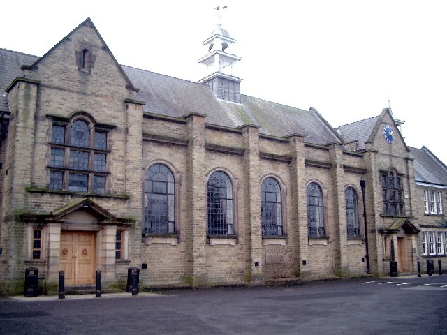
Clitheroe Royal
Grammar School. This building is the former Boys' Grammar School (founded 1554). It now houses the 6th form college of the combined boys' and girls'schools.
442:
1011:
966:
921:
854:
816:
778:
645:
621:
533:
446:
438:
430:
858:
740:
637:
633:
629:
577:
434:
426:
1107:
584:"}},"text\/plain":{"en":{"P275":"Creative Commons Attribution-ShareAlike 2.0 Generic"}}}}": -->
906:
675:
607:
563:
230:
1096:
1091:
42:
710:
268:
1159:
This file contains additional information, probably added from the digital camera or scanner used to create or digitize it.
358:
505:
1025:
980:
935:
872:
826:
788:
718:
659:
547:
513:
498:
483:
899:
750:
703:
688:
591:
456:
415:
1128:
314:
1162:
If the file has been modified from its original state, some details may not fully reflect the modified file.
357:– If you remix, transform, or build upon the material, you must distribute your contributions under the
275:
on the
Geograph website for the photographer's contact details. The copyright on this image is owned by
928:"}},"text\/plain":{"en":{"P3575":"77,190 byte"}}}}": -->
540:"}},"text\/plain":{"en":{"P6216":"copyrighted"}}}}": -->
1124:
The following pages on the
English Knowledge use this file (pages on other projects are not listed):
1018:"}},"text\/plain":{"en":{"P2049":"640 pixel"}}}}": -->
973:"}},"text\/plain":{"en":{"P2048":"480 pixel"}}}}": -->
91:
652:"}},"text\/plain":{"en":{"P7384":"101123"}}}}": -->
183:
865:"}},"text\/plain":{"en":{"P459":"SHA-1"}}}}": -->
725:
695:
490:
311:
167:
8:
255:
236:
280:
78:
405:
156:
146:
1035:
990:
945:
882:
836:
798:
760:
669:
601:
557:
466:
260:
272:
1064:
Click on a date/time to view the file as it appeared at that time.
222:
116:
Clitheroe Royal
Grammar School - geograph.org.uk - 101123.jpg
52:
Clitheroe_Royal_Grammar_School_-_geograph.org.uk_-_101123.jpg
215:
53° 52′ 30″ N, 2° 23′ 13″ W
135:
66:
399:
Add a one-line explanation of what this file represents
1146:
1122:
1137:
1062:
90:
Commons is a freely licensed media file repository.
608:
Creative
Commons Attribution-ShareAlike 2.0 Generic
582:
Creative
Commons Attribution-ShareAlike 2.0 Generic
56:(640 × 480 pixels, file size: 75 KB, MIME type:
368:https://creativecommons.org/licenses/by-sa/2.0
71:
374:Creative Commons Attribution-Share Alike 2.0
292:
131:
113:
634:https:\/\/www.geograph.org.uk\/photo\/101123
435:https:\/\/www.geograph.org.uk\/profile\/1380
152:
141:
14:
1015:
970:
925:
334:– to copy, distribute and transmit the work
1139:The following other wikis use this file:
888:3b8afb5552f8efbde18664b8b0080a4046fbca47
696:https://www.geograph.org.uk/photo/101123
491:https://www.geograph.org.uk/profile/1380
229:View this and other nearby images on:
190:
102:
279:and is licensed for reuse under the
205:
1055:
315:Attribution-Share Alike 2.0 Generic
303:
298:
283:Attribution-ShareAlike 2.0 license.
196:Mike and Kirsty Grundy /
177:Mike and Kirsty Grundy /
13:
1157:
404:
398:
289:
266:
120:
103:
49:
1183:
1164:
403:
1123:
389:
345:Under the following conditions:
310:This file is licensed under the
302:
297:
291:
259:
235:
221:
70:
31:
21:
386:
121:
46:No higher resolution available.
1134:
1129:Clitheroe Royal Grammar School
1059:
676:file available on the internet
626:file available on the internet
385:
267:This image was taken from the
198:Clitheroe Royal Grammar School
179:Clitheroe Royal Grammar School
26:
1:
789:coordinates of depicted place
779:coordinates of depicted place
36:
1119:
711:Geograph Britain and Ireland
642:Geograph Britain and Ireland
499:object of statement has role
439:object of statement has role
411:Items portrayed in this file
251:
7:
1154:
10:
1188:
1143:Usage on www.wikidata.org
359:same or compatible license
110:
105:
1056:
804:53°52'29.6"N, 2°23'13.2"W
16:
719:geograph.org.uk image ID
646:geograph.org.uk image ID
388:
325:
77:This is a file from the
41:
1113:
168:required by the license
134:
81:. Information from its
1092:22:21, 30 January 2010
520:Mike and Kirsty Grundy
322:Mike and Kirsty Grundy
277:Mike and Kirsty Grundy
273:this photograph's page
241:53.874900; -2.387000
157:Mike and Kirsty Grundy
84:description page there
900:determination method
859:determination method
340:– to adapt the work
514:author name string
447:author name string
1175:
1174:
1135:Global file usage
1117:
1017:
972:
927:
592:copyright license
578:copyright license
397:
288:
287:
271:collection. See
246:
245:
203:
202:
171:
99:
98:
79:Wikimedia Commons
32:Global file usage
1179:
1165:
1104:
1066:
1044:
999:
954:
909:
904:
728:
723:
713:
708:
698:
693:
689:described at URL
630:described at URL
548:copyright status
534:copyright status
521:
518:
508:
503:
493:
488:
395:
381:
378:
375:
372:
369:
361:as the original.
323:
312:Creative Commons
306:
305:
301:
300:
295:
294:
281:Creative Commons
269:Geograph project
263:
256:
242:
239:
225:
224:
218:
217:
206:
165:
137:
125:
117:
111:
95:
74:
73:
67:
61:
59:
1187:
1186:
1182:
1181:
1180:
1178:
1177:
1176:
1153:
1133:
1125:
1118:
1110:
1102:
1058:
1057:
1054:
1053:
1052:
1051:
1050:
1049:
1048:
1047:
1045:
1042:
1032:
1031:
1030:
1028:
1009:
1008:
1007:
1006:
1005:
1004:
1003:
1002:
1000:
997:
987:
986:
985:
983:
964:
963:
962:
961:
960:
959:
958:
957:
955:
952:
942:
941:
940:
938:
919:
918:
917:
916:
915:
914:
913:
912:
911:
910:
905:
902:
893:
892:
891:
889:
879:
878:
877:
875:
852:
851:
850:
849:
848:
847:
846:
845:
843:
833:
832:
831:
829:
814:
813:
812:
811:
810:
809:
808:
807:
805:
795:
794:
793:
791:
776:
775:
774:
773:
772:
771:
770:
769:
767:
757:
756:
755:
753:
738:
737:
736:
735:
734:
733:
732:
731:
730:
729:
724:
721:
715:
714:
709:
706:
700:
699:
694:
691:
682:
681:
680:
678:
666:
665:
664:
662:
619:
618:
617:
616:
615:
614:
613:
612:
610:
598:
597:
596:
594:
575:
574:
573:
572:
571:
570:
569:
568:
566:
554:
553:
552:
550:
531:
530:
529:
528:
527:
526:
525:
524:
523:
522:
519:
516:
510:
509:
504:
501:
495:
494:
489:
486:
477:
476:
475:
473:
463:
462:
461:
459:
424:
423:
422:
421:
420:
418:
402:
401:
400:
383:
382:
379:
376:
373:
370:
367:
366:
324:
321:
318:
307:
284:
254:
240:
213:
212:
209:Object location
204:
193:
186:
174:
147:geograph.org.uk
127:
115:
108:
101:
100:
89:
88:
87:is shown below.
63:
57:
55:
48:
47:
12:
11:
5:
1185:
1173:
1172:
1169:
1156:
1152:
1151:
1150:
1149:
1136:
1132:
1131:
1121:
1116:
1115:
1112:
1108:
1105:
1099:
1094:
1089:
1085:
1084:
1081:
1078:
1075:
1072:
1069:
1061:
1046:
1040:
1038:
1037:
1036:
1034:
1033:
1029:
1024:
1022:
1021:
1020:
1019:
1013:
1001:
995:
993:
992:
991:
989:
988:
984:
979:
977:
976:
975:
974:
968:
956:
950:
948:
947:
946:
944:
943:
939:
934:
932:
931:
930:
929:
923:
898:
897:
896:
895:
894:
890:
887:
885:
884:
883:
881:
880:
876:
871:
869:
868:
867:
866:
864:
860:
856:
844:
841:
839:
838:
837:
835:
834:
830:
825:
823:
822:
821:
820:
818:
806:
803:
801:
800:
799:
797:
796:
792:
787:
785:
784:
783:
782:
780:
768:
766:4 January 2006
765:
763:
762:
761:
759:
758:
754:
749:
747:
746:
745:
744:
742:
717:
716:
702:
701:
687:
686:
685:
684:
683:
679:
674:
672:
671:
670:
668:
667:
663:
660:source of file
658:
656:
655:
654:
653:
651:
647:
643:
639:
635:
631:
627:
623:
622:source of file
611:
606:
604:
603:
602:
600:
599:
595:
590:
588:
587:
586:
585:
583:
579:
567:
562:
560:
559:
558:
556:
555:
551:
546:
544:
543:
542:
541:
539:
535:
512:
511:
497:
496:
482:
481:
480:
479:
478:
474:
471:
469:
468:
467:
465:
464:
460:
455:
453:
452:
451:
450:
448:
444:
440:
436:
432:
428:
419:
414:
412:
409:
408:
407:
406:
394:
393:
390:
387:
365:
364:
363:
362:
352:
343:
342:
341:
335:
328:You are free:
319:
309:
308:
290:
286:
285:
264:
253:
250:
244:
243:
233:
227:
210:
201:
200:
194:
191:
188:
187:
182:
175:
172:
160:
159:
154:
150:
149:
143:
139:
138:
136:4 January 2006
133:
129:
128:
118:
109:
107:
104:
97:
96:
75:
65:
64:
45:
40:
39:
34:
29:
24:
19:
9:
6:
4:
3:
2:
1184:
1170:
1167:
1166:
1163:
1160:
1148:
1145:
1144:
1142:
1141:
1140:
1130:
1127:
1126:
1111:
1106:
1100:
1098:
1095:
1093:
1090:
1087:
1086:
1082:
1079:
1076:
1073:
1070:
1068:
1067:
1065:
1039:
1027:
1023:
994:
982:
978:
949:
937:
933:
908:
901:
886:
874:
870:
840:
828:
824:
802:
790:
786:
764:
752:
748:
727:
720:
712:
705:
697:
690:
677:
673:
661:
657:
609:
605:
593:
589:
565:
561:
549:
545:
515:
507:
500:
492:
485:
470:
458:
454:
417:
413:
410:
391:
384:
371:CC BY-SA 2.0
360:
356:
353:
350:
347:
346:
344:
339:
336:
333:
330:
329:
327:
326:
320:Attribution:
316:
313:
296:
282:
278:
274:
270:
265:
262:
258:
257:
249:
248:
238:
234:
232:
231:OpenStreetMap
228:
226:
216:
211:
208:
207:
199:
195:
189:
185:
181: /
180:
176:
169:
164:
162:
161:
158:
155:
151:
148:
144:
140:
130:
124:
119:
112:
93:
86:
85:
80:
76:
69:
68:
62:
53:
44:
38:
35:
33:
30:
28:
25:
23:
20:
18:
15:
1161:
1158:
1138:
1063:
1060:File history
506:photographer
443:photographer
354:
348:
337:
331:
276:
247:
197:
184:CC BY-SA 2.0
178:
122:
92:You can help
82:
50:
22:File history
1109:GeographBot
564:copyrighted
538:copyrighted
355:share alike
349:attribution
163:Attribution
114:Description
1168:_error
1120:File usage
1101:640 × 480
1077:Dimensions
842:image/jpeg
827:media type
817:media type
472:some value
58:image/jpeg
27:File usage
1074:Thumbnail
1071:Date/Time
936:data size
922:data size
751:inception
741:inception
252:Licensing
192:InfoField
173:InfoField
123:English:
1155:Metadata
1147:Q5134440
873:checksum
855:checksum
704:operator
638:operator
392:Captions
338:to remix
332:to share
317:license.
37:Metadata
1103:(75 KB)
1088:current
1083:Comment
951:77,190
457:creator
427:creator
416:depicts
396:English
106:Summary
54:
981:height
967:height
726:101123
650:101123
219:
153:Author
142:Source
1043:pixel
1026:width
1016:pixel
1012:width
998:pixel
971:pixel
907:SHA-1
863:SHA-1
145:From
1080:User
1041:640
996:480
953:byte
926:byte
380:true
377:true
132:Date
17:File
484:URL
431:URL
903::
722::
707::
692::
517::
502::
487::
1171:0
170:)
166:(
94:.
60:)
_&language=en)
