558:"}},"text\/plain":{"en":{"":"checksum"}}},"{\"value\":\"fe13492d45785dc3e4a950b83423c8cf681cf40b\",\"type\":\"string\"}":{"text\/html":{"en":{"P4092":"fe13492d45785dc3e4a950b83423c8cf681cf40b"}},"text\/plain":{"en":{"P4092":"fe13492d45785dc3e4a950b83423c8cf681cf40b"}}},"{\"value\":{\"entity-type\":\"property\",\"numeric-id\":459,\"id\":\"P459\"},\"type\":\"wikibase-entityid\"}":{"text\/html":{"en":{"":"
482:"}},"text\/plain":{"en":{"":"inception"}}},"{\"value\":{\"time\":\"+2010-11-30T00:00:00Z\",\"timezone\":0,\"before\":0,\"after\":0,\"precision\":11,\"calendarmodel\":\"http:\\\/\\\/www.wikidata.org\\\/entity\\\/Q1985727\"},\"type\":\"time\"}":{"text\/html":{"en":{"P571":"30 November 2010"}},"text\/plain":{"en":{"P571":"30 November 2010"}}}}": -->
38:
242:
554:
253:
94:
562:"}},"text\/plain":{"en":{"":"determination method"}}},"{\"value\":{\"entity-type\":\"item\",\"numeric-id\":13414952,\"id\":\"Q13414952\"},\"type\":\"wikibase-entityid\"}":{"text\/html":{"en":{"P459":"
520:"}},"text\/plain":{"en":{"":"media type"}}},"{\"value\":\"image\\\/jpeg\",\"type\":\"string\"}":{"text\/html":{"en":{"P1163":"image\/jpeg"}},"text\/plain":{"en":{"P1163":"image\/jpeg"}}}}": -->
438:"}},"text\/plain":{"en":{"":"copyright license"}}},"{\"value\":{\"entity-type\":\"item\",\"numeric-id\":14946043,\"id\":\"Q14946043\"},\"type\":\"wikibase-entityid\"}":{"text\/html":{"en":{"P275":"
394:"}},"text\/plain":{"en":{"":"copyright status"}}},"{\"value\":{\"entity-type\":\"item\",\"numeric-id\":50423863,\"id\":\"Q50423863\"},\"type\":\"wikibase-entityid\"}":{"text\/html":{"en":{"P6216":"
625:"}},"text\/plain":{"en":{"":"data size"}}},"{\"value\":{\"amount\":\"+259597\",\"unit\":\"http:\\\/\\\/www.wikidata.org\\\/entity\\\/Q8799\"},\"type\":\"quantity\"}":{"text\/html":{"en":{"P3575":"259,597
670:"}},"text\/plain":{"en":{"":"height"}}},"{\"value\":{\"amount\":\"+2146\",\"unit\":\"http:\\\/\\\/www.wikidata.org\\\/entity\\\/Q355198\"},\"type\":\"quantity\"}":{"text\/html":{"en":{"P2048":"2,146
715:"}},"text\/plain":{"en":{"":"width"}}},"{\"value\":{\"amount\":\"+2010\",\"unit\":\"http:\\\/\\\/www.wikidata.org\\\/entity\\\/Q355198\"},\"type\":\"quantity\"}":{"text\/html":{"en":{"P2049":"2,010
711:
300:– You must give appropriate credit, provide a link to the license, and indicate if changes were made. You may do so in any reasonable manner, but not in any way that suggests the licensor endorses you or your use.
819:, UK. Equirectangular map projection on WGS 84 datum, with N/S stretched 160% Geographic limits: *West: 3.35W *East: 3.05W *North: 51.57N *South: 51.37N |Source=[[w:Ordnance Survey|Ordnance S
1001:
563:
439:
395:
712:
667:
622:
555:
517:
391:
559:
479:
435:
1036:
1081:
60:
56:
52:
48:
42:
105:
1071:
73:
442:"}},"text\/plain":{"en":{"P275":"Creative Commons Attribution-ShareAlike 3.0 Unported"}}}}": -->
938:
231:
1096:
961:
607:
465:
421:
933:
1066:
202:
307:
1061:
1011:
726:
681:
636:
573:
527:
405:
600:
489:
449:
380:
263:
853:
306:– If you remix, transform, or build upon the material, you must distribute your contributions under the
893:
629:"}},"text\/plain":{"en":{"P3575":"259,597 byte"}}}}": -->
1171:
838:
719:"}},"text\/plain":{"en":{"P2049":"2,010 pixel"}}}}": -->
674:"}},"text\/plain":{"en":{"P2048":"2,146 pixel"}}}}": -->
398:"}},"text\/plain":{"en":{"P6216":"copyrighted"}}}}": -->
991:
913:
829:
The following pages on the
English Knowledge use this file (pages on other projects are not listed):
797:
792:
64:
37:
888:
833:
340:
185:
843:
113:
956:
1166:
1091:
1046:
868:
566:"}},"text\/plain":{"en":{"P459":"SHA-1"}}}}": -->
873:
1016:
260:
8:
898:
883:
1181:
1156:
903:
863:
206:
1026:
878:
858:
100:
370:
1151:
1141:
908:
182:
971:
219:
1211:
1191:
1056:
918:
808:
928:
736:
691:
646:
583:
537:
499:
459:
415:
1126:
1111:
848:
1131:
1116:
145:
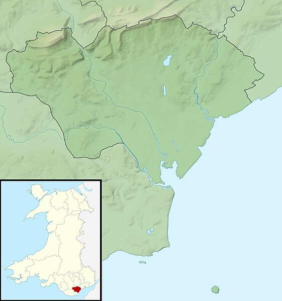
Equirectangular map projection on WGS 84 datum, with N/S stretched 160%
923:
195:
Administrative borders and coastline data from
Boundary-Line product.
1012:
Wikiproyecto:Ilustración/Taller de
Cartografía/Realizaciones/Europa
765:
Click on a date/time to view the file as it appeared at that time.
139:
271:
Contains
Ordnance Survey data © Crown copyright and database right
816:
981:
171:
88:
1106:
992:
Vorlage:Positionskarte Wales City and County of
Cardiff
364:
Add a one-line explanation of what this file represents
986:
827:
78:(2,010 × 2,146 pixels, file size: 254 KB, MIME type:
947:
763:
466:
Creative
Commons Attribution-ShareAlike 3.0 Unported
440:
Creative
Commons Attribution-ShareAlike 3.0 Unported
112:
Commons is a freely licensed media file repository.
1201:
198:All other geographic data from Meridian 2 product.
1172:Modül:Konum haritası/veri/Galler Cardiff/belge
317:https://creativecommons.org/licenses/by-sa/3.0
93:
323:Creative Commons Attribution-Share Alike 3.0
241:
226:
167:
130:
336:
215:
192:Relief data from Land-Form Panorama product.
177:
14:
716:
671:
626:
283:– to copy, distribute and transmit the work
1157:Module:Location map/data/Wales Cardiff/doc
939:Module:Location map/data/Wales Cardiff/doc
1067:モジュール:Location map/data/Wales Cardiff/doc
1017:Plantilla:Mapa de localización de Cardiff
949:The following other wikis use this file:
815:{{Information |Description=Relief map of
1167:Modül:Konum haritası/veri/Galler Cardiff
589:fe13492d45785dc3e4a950b83423c8cf681cf40b
1097:모듈:Location map/data/Wales Cardiff/설명문서
1152:Module:Location map/data/Wales Cardiff
934:Module:Location map/data/Wales Cardiff
1062:モジュール:Location map/data/Wales Cardiff
203:File: United Kingdom location map.svg
124:
1082:ಟೆಂಪ್ಲೇಟು:Location map Wales Cardiff
972:Plantilya:Location map Wales Cardiff
264:Attribution-Share Alike 3.0 Unported
222:, created using Ordnance Survey data
1212:Template:Location map Wales Cardiff
1057:Template:Location map Wales Cardiff
1002:Πρότυπο:Location map Ουαλία Κάρντιφ
756:
252:
247:
13:
1192:Batakan:Location map Wales Cardiff
1092:모듈:Location map/data/Wales Cardiff
369:
363:
238:
133:Cardiff UK relief location map.jpg
125:
71:
1225:
1142:Šablon:Location map Wales Cardiff
368:
828:
354:
294:Under the following conditions:
259:This file is licensed under the
251:
246:
240:
201:Inset derived from derived from
92:
31:
21:
957:قالب:Location map Wales Cardiff
351:
1047:Sablon:Pozíciós térkép Cardiff
1027:Modèle:Géolocalisation/Cardiff
944:
854:Bishop's Palace, Llandaff
760:
350:
26:
1:
824:
376:Items portrayed in this file
7:
1188:Usage on war.wikipedia.org
968:Usage on ceb.wikipedia.org
10:
1230:
1208:Usage on zh.wikipedia.org
1198:Usage on www.wikidata.org
1178:Usage on tt.wikipedia.org
1163:Usage on tr.wikipedia.org
1148:Usage on si.wikipedia.org
1138:Usage on sh.wikipedia.org
1123:Usage on pl.wikibooks.org
1103:Usage on pl.wikipedia.org
1088:Usage on ko.wikipedia.org
1078:Usage on kn.wikipedia.org
1053:Usage on ja.wikipedia.org
1043:Usage on hu.wikipedia.org
1033:Usage on he.wikipedia.org
1023:Usage on fr.wikipedia.org
1008:Usage on es.wikipedia.org
998:Usage on el.wikipedia.org
978:Usage on de.wikipedia.org
953:Usage on ar.wikipedia.org
914:St Padarn's Institute
894:Shah Jalal Mosque, Cardiff
308:same or compatible license
127:
839:2-4 High Street, Llandaff
757:
16:
889:Morganstown Castle Mound
834:19 High Street, Llandaff
353:
274:
99:This is a file from the
36:
1127:Moduł:Mapa/dane/Cardiff
1112:Moduł:Mapa/dane/Cardiff
844:6 High Street, Llandaff
814:
793:00:56, 30 November 2011
341:File:Cardiff UK map.svg
170:
103:. Information from its
1132:Moduł:Mapa/dane/GB-CRF
1117:Moduł:Mapa/dane/GB-CRF
1037:תבנית:מפת מיקום/קארדיף
869:Hayes Island Snack Bar
106:description page there
41:Size of this preview:
874:Jackson Hall, Cardiff
601:determination method
560:determination method
65:2,010 × 2,146 pixels
899:St Andrew, Llandaff
884:Llanishen Reservoir
289:– to adapt the work
148:Geographic limits:
47:Other resolutions:
904:St Cross, Llandaff
864:Craig-y-parc House
61:959 × 1,024 pixels
945:Global file usage
879:Lisvane Reservoir
859:Caer Castell Camp
822:
718:
673:
628:
450:copyright license
436:copyright license
362:
347:
346:
235:
232:Reusing this file
121:
120:
101:Wikimedia Commons
32:Global file usage
1221:
962:قلعة سانت فاجانس
909:St Fagans Castle
805:
767:
745:
700:
655:
610:
605:
505:30 November 2010
406:copyright status
392:copyright status
360:
330:
327:
324:
321:
318:
310:as the original.
272:
261:Creative Commons
255:
254:
250:
249:
244:
243:
229:
173:
172:30 November 2010
134:
128:
117:
96:
95:
89:
83:
81:
68:
57:719 × 768 pixels
53:450 × 480 pixels
49:225 × 240 pixels
43:561 × 599 pixels
1229:
1228:
1224:
1223:
1222:
1220:
1219:
1218:
943:
830:
823:
811:
803:
759:
758:
755:
754:
753:
752:
751:
750:
749:
748:
746:
743:
733:
732:
731:
729:
710:
709:
708:
707:
706:
705:
704:
703:
701:
698:
688:
687:
686:
684:
665:
664:
663:
662:
661:
660:
659:
658:
656:
653:
643:
642:
641:
639:
620:
619:
618:
617:
616:
615:
614:
613:
612:
611:
606:
603:
594:
593:
592:
590:
580:
579:
578:
576:
553:
552:
551:
550:
549:
548:
547:
546:
544:
534:
533:
532:
530:
515:
514:
513:
512:
511:
510:
509:
508:
506:
496:
495:
494:
492:
477:
476:
475:
474:
473:
472:
471:
470:
468:
456:
455:
454:
452:
433:
432:
431:
430:
429:
428:
427:
426:
424:
412:
411:
410:
408:
389:
388:
387:
386:
385:
383:
367:
366:
365:
348:
332:
331:
328:
325:
322:
319:
316:
315:
273:
270:
267:
256:
183:Ordnance Survey
132:
123:
122:
111:
110:
109:is shown below.
85:
79:
77:
70:
69:
46:
12:
11:
5:
1227:
1217:
1216:
1215:
1214:
1206:
1205:
1204:
1196:
1195:
1194:
1186:
1185:
1184:
1176:
1175:
1174:
1169:
1161:
1160:
1159:
1154:
1146:
1145:
1144:
1136:
1135:
1134:
1129:
1121:
1120:
1119:
1114:
1109:
1101:
1100:
1099:
1094:
1086:
1085:
1084:
1076:
1075:
1074:
1069:
1064:
1059:
1051:
1050:
1049:
1041:
1040:
1039:
1031:
1030:
1029:
1021:
1020:
1019:
1014:
1006:
1005:
1004:
996:
995:
994:
989:
984:
976:
975:
974:
966:
965:
964:
959:
946:
942:
941:
936:
931:
926:
921:
919:Twmpath Castle
916:
911:
906:
901:
896:
891:
886:
881:
876:
871:
866:
861:
856:
851:
846:
841:
836:
826:
821:
820:
813:
809:
806:
802:2,010 × 2,146
800:
795:
790:
786:
785:
782:
779:
776:
773:
770:
762:
747:
741:
739:
738:
737:
735:
734:
730:
725:
723:
722:
721:
720:
714:
702:
696:
694:
693:
692:
690:
689:
685:
680:
678:
677:
676:
675:
669:
657:
651:
649:
648:
647:
645:
644:
640:
635:
633:
632:
631:
630:
624:
599:
598:
597:
596:
595:
591:
588:
586:
585:
584:
582:
581:
577:
572:
570:
569:
568:
567:
565:
561:
557:
545:
542:
540:
539:
538:
536:
535:
531:
526:
524:
523:
522:
521:
519:
507:
504:
502:
501:
500:
498:
497:
493:
488:
486:
485:
484:
483:
481:
469:
464:
462:
461:
460:
458:
457:
453:
448:
446:
445:
444:
443:
441:
437:
425:
420:
418:
417:
416:
414:
413:
409:
404:
402:
401:
400:
399:
397:
393:
384:
379:
377:
374:
373:
372:
371:
359:
358:
355:
352:
345:
344:
338:
337:Other versions
334:
333:
314:
313:
312:
311:
301:
292:
291:
290:
284:
277:You are free:
268:
258:
257:
239:
236:
224:
223:
217:
213:
212:
211:
210:
199:
196:
193:
179:
175:
174:
169:
165:
164:
163:
162:
159:
156:
153:
138:Relief map of
135:
126:
119:
118:
97:
87:
86:
40:
35:
34:
29:
24:
19:
9:
6:
4:
3:
2:
1226:
1213:
1210:
1209:
1207:
1203:
1200:
1199:
1197:
1193:
1190:
1189:
1187:
1183:
1180:
1179:
1177:
1173:
1170:
1168:
1165:
1164:
1162:
1158:
1155:
1153:
1150:
1149:
1147:
1143:
1140:
1139:
1137:
1133:
1130:
1128:
1125:
1124:
1122:
1118:
1115:
1113:
1110:
1108:
1105:
1104:
1102:
1098:
1095:
1093:
1090:
1089:
1087:
1083:
1080:
1079:
1077:
1073:
1070:
1068:
1065:
1063:
1060:
1058:
1055:
1054:
1052:
1048:
1045:
1044:
1042:
1038:
1035:
1034:
1032:
1028:
1025:
1024:
1022:
1018:
1015:
1013:
1010:
1009:
1007:
1003:
1000:
999:
997:
993:
990:
988:
985:
983:
980:
979:
977:
973:
970:
969:
967:
963:
960:
958:
955:
954:
952:
951:
950:
940:
937:
935:
932:
930:
927:
925:
922:
920:
917:
915:
912:
910:
907:
905:
902:
900:
897:
895:
892:
890:
887:
885:
882:
880:
877:
875:
872:
870:
867:
865:
862:
860:
857:
855:
852:
850:
847:
845:
842:
840:
837:
835:
832:
831:
818:
812:
807:
801:
799:
796:
794:
791:
788:
787:
783:
780:
777:
774:
771:
769:
768:
766:
740:
728:
724:
695:
683:
679:
650:
638:
634:
609:
602:
587:
575:
571:
541:
529:
525:
503:
491:
487:
467:
463:
451:
447:
423:
419:
407:
403:
382:
378:
375:
356:
349:
342:
339:
335:
320:CC BY-SA 3.0
309:
305:
302:
299:
296:
295:
293:
288:
285:
282:
279:
278:
276:
275:
269:Attribution:
265:
262:
245:
237:
233:
228:
225:
221:
218:
214:
208:
204:
200:
197:
194:
191:
190:
189:
187:
184:
180:
176:
166:
161:South: 51.37N
160:
158:North: 51.57N
157:
154:
151:
150:
149:
146:
143:
141:
136:
129:
115:
108:
107:
102:
98:
91:
90:
84:
75:
74:Original file
66:
62:
58:
54:
50:
44:
39:
33:
30:
28:
25:
23:
20:
18:
15:
982:Castell Coch
948:
929:Wenallt Camp
764:
761:File history
303:
297:
286:
280:
207:NordNordWest
181:
147:
144:
137:
114:You can help
104:
72:
22:File history
1072:セント・フェーガンス城
849:Animal Wall
422:copyrighted
396:copyrighted
343:- Blank map
304:share alike
298:attribution
155:East: 3.05W
152:West: 3.35W
131:Description
1107:Garth Hill
825:File usage
778:Dimensions
543:image/jpeg
528:media type
518:media type
227:Permission
80:image/jpeg
27:File usage
987:Flat Holm
924:Ty Bronna
810:Nilfanion
775:Thumbnail
772:Date/Time
637:data size
623:data size
490:inception
480:inception
220:Nilfanion
804:(254 KB)
652:259,597
574:checksum
556:checksum
357:Captions
287:to remix
281:to share
266:license.
186:OpenData
1182:Кардифф
817:Cardiff
789:current
784:Comment
381:depicts
361:English
140:Cardiff
76:
1202:Q10690
742:2,010
697:2,146
682:height
668:height
216:Author
178:Source
142:, UK.
744:pixel
727:width
717:pixel
713:width
699:pixel
672:pixel
608:SHA-1
564:SHA-1
781:User
654:byte
627:byte
329:true
326:true
168:Date
17:File
205:by
604::
188:.
63:|
59:|
55:|
51:|
45:.
234:)
230:(
209:.
116:.
82:)
67:.
