898:"}},"text\/plain":{"en":{"":"checksum"}}},"{\"value\":\"2992b1a894884893fd538e1d8a54e2bf2e089759\",\"type\":\"string\"}":{"text\/html":{"en":{"P4092":"2992b1a894884893fd538e1d8a54e2bf2e089759"}},"text\/plain":{"en":{"P4092":"2992b1a894884893fd538e1d8a54e2bf2e089759"}}},"{\"value\":{\"entity-type\":\"property\",\"numeric-id\":459,\"id\":\"P459\"},\"type\":\"wikibase-entityid\"}":{"text\/html":{"en":{"":"
778:"}},"text\/plain":{"en":{"":"coordinates of depicted place"}}},"{\"value\":{\"latitude\":50.753,\"longitude\":-1.765,\"altitude\":null,\"precision\":0.0001,\"globe\":\"http:\\\/\\\/www.wikidata.org\\\/entity\\\/Q2\"},\"type\":\"globecoordinate\"}":{"text\/html":{"en":{"P9149":"50\u00b045'10.8"N, 1\u00b045'54.0"W"}},"text\/plain":{"en":{"P9149":"50\u00b045'10.8\"N, 1\u00b045'54.0\"W"}}}}": -->
438:"}},"text\/plain":{"en":{"":"author name string"}}},"{\"value\":\"Stuart Buchan\",\"type\":\"string\"}":{"text\/html":{"en":{"P2093":"Stuart Buchan"}},"text\/plain":{"en":{"P2093":"Stuart Buchan"}}},"{\"value\":{\"entity-type\":\"property\",\"numeric-id\":3831,\"id\":\"P3831\"},\"type\":\"wikibase-entityid\"}":{"text\/html":{"en":{"":"
621:"}},"text\/plain":{"en":{"":"inception"}}},"{\"value\":{\"time\":\"+2005-11-04T00:00:00Z\",\"timezone\":0,\"before\":0,\"after\":0,\"precision\":11,\"calendarmodel\":\"http:\\\/\\\/www.wikidata.org\\\/entity\\\/Q1985727\"},\"type\":\"time\"}":{"text\/html":{"en":{"P571":"4 November 2005"}},"text\/plain":{"en":{"P571":"4 November 2005"}}}}": -->
655:
422:
894:
258:
296:
301:
72:
434:"}},"text\/plain":{"en":{"P2699":"https:\/\/www.geograph.org.uk\/profile\/299"}}},"{\"value\":{\"entity-type\":\"property\",\"numeric-id\":2093,\"id\":\"P2093\"},\"type\":\"wikibase-entityid\"}":{"text\/html":{"en":{"":"
663:"}},"text\/plain":{"en":{"P7482":"file available on the internet"}}},"{\"value\":{\"entity-type\":\"property\",\"numeric-id\":137,\"id\":\"P137\"},\"type\":\"wikibase-entityid\"}":{"text\/html":{"en":{"":"
671:"}},"text\/plain":{"en":{"P137":"Geograph Britain and Ireland"}}},"{\"value\":{\"entity-type\":\"property\",\"numeric-id\":7384,\"id\":\"P7384\"},\"type\":\"wikibase-entityid\"}":{"text\/html":{"en":{"":"
442:"}},"text\/plain":{"en":{"":"object of statement has role"}}},"{\"value\":{\"entity-type\":\"item\",\"numeric-id\":33231,\"id\":\"Q33231\"},\"type\":\"wikibase-entityid\"}":{"text\/html":{"en":{"P3831":"
902:"}},"text\/plain":{"en":{"":"determination method"}}},"{\"value\":{\"entity-type\":\"item\",\"numeric-id\":13414952,\"id\":\"Q13414952\"},\"type\":\"wikibase-entityid\"}":{"text\/html":{"en":{"P459":"
860:"}},"text\/plain":{"en":{"":"media type"}}},"{\"value\":\"image\\\/jpeg\",\"type\":\"string\"}":{"text\/html":{"en":{"P1163":"image\/jpeg"}},"text\/plain":{"en":{"P1163":"image\/jpeg"}}}}": -->
577:"}},"text\/plain":{"en":{"":"copyright license"}}},"{\"value\":{\"entity-type\":\"item\",\"numeric-id\":19068220,\"id\":\"Q19068220\"},\"type\":\"wikibase-entityid\"}":{"text\/html":{"en":{"P275":"
533:"}},"text\/plain":{"en":{"":"copyright status"}}},"{\"value\":{\"entity-type\":\"item\",\"numeric-id\":50423863,\"id\":\"Q50423863\"},\"type\":\"wikibase-entityid\"}":{"text\/html":{"en":{"P6216":"
659:"}},"text\/plain":{"en":{"":"source of file"}}},"{\"value\":{\"entity-type\":\"item\",\"numeric-id\":74228490,\"id\":\"Q74228490\"},\"type\":\"wikibase-entityid\"}":{"text\/html":{"en":{"P7482":"
965:"}},"text\/plain":{"en":{"":"data size"}}},"{\"value\":{\"amount\":\"+118065\",\"unit\":\"http:\\\/\\\/www.wikidata.org\\\/entity\\\/Q8799\"},\"type\":\"quantity\"}":{"text\/html":{"en":{"P3575":"118,065
816:"}},"text\/plain":{"en":{"":"captured with"}}},"{\"value\":{\"entity-type\":\"item\",\"numeric-id\":5507399,\"id\":\"Q5507399\"},\"type\":\"wikibase-entityid\"}":{"text\/html":{"en":{"P4082":"
1010:"}},"text\/plain":{"en":{"":"height"}}},"{\"value\":{\"amount\":\"+481\",\"unit\":\"http:\\\/\\\/www.wikidata.org\\\/entity\\\/Q355198\"},\"type\":\"quantity\"}":{"text\/html":{"en":{"P2048":"481
667:"}},"text\/plain":{"en":{"":"operator"}}},"{\"value\":{\"entity-type\":\"item\",\"numeric-id\":1503119,\"id\":\"Q1503119\"},\"type\":\"wikibase-entityid\"}":{"text\/html":{"en":{"P137":"
1055:"}},"text\/plain":{"en":{"":"width"}}},"{\"value\":{\"amount\":\"+640\",\"unit\":\"http:\\\/\\\/www.wikidata.org\\\/entity\\\/Q355198\"},\"type\":\"quantity\"}":{"text\/html":{"en":{"P2049":"640
679:"}},"text\/plain":{"en":{"P7384":"74345"}}},"{\"value\":{\"entity-type\":\"property\",\"numeric-id\":973,\"id\":\"P973\"},\"type\":\"wikibase-entityid\"}":{"text\/html":{"en":{"":"
426:"}},"text\/plain":{"en":{"":"creator"}}},"{\"value\":{\"entity-type\":\"property\",\"numeric-id\":2699,\"id\":\"P2699\"},\"type\":\"wikibase-entityid\"}":{"text\/html":{"en":{"":"
1051:
683:"}},"text\/plain":{"en":{"":"described at URL"}}},"{\"value\":\"https:\\\/\\\/www.geograph.org.uk\\\/photo\\\/74345\",\"type\":\"string\"}":{"text\/html":{"en":{"P973":"
430:"}},"text\/plain":{"en":{"":"URL"}}},"{\"value\":\"https:\\\/\\\/www.geograph.org.uk\\\/profile\\\/299\",\"type\":\"string\"}":{"text\/html":{"en":{"P2699":"
43:
675:"}},"text\/plain":{"en":{"":"geograph.org.uk image ID"}}},"{\"value\":\"74345\",\"type\":\"string\"}":{"text\/html":{"en":{"P7384":"
1155:== {{int:filedesc}} == {{Information |description={{en|1=Burton, Dorset. Burton Village is a lovely self contained village on the edge of the New Forest. Note the compass rose in the foreground.}} |date=2005-11-04 |source=From [http://www.geograph.org.uk/
214:
348:– You must give appropriate credit, provide a link to the license, and indicate if changes were made. You may do so in any reasonable manner, but not in any way that suggests the licensor endorses you or your use.
1364:
220:
903:
660:
578:
534:
676:
817:
668:
443:
1052:
1007:
962:
895:
857:
813:
775:
672:
656:
530:
439:
435:
427:
899:
680:
664:
618:
574:
423:
83:
51:
684:
431:
1148:
581:"}},"text\/plain":{"en":{"P275":"Creative Commons Attribution-ShareAlike 2.0 Generic"}}}}": -->
126:
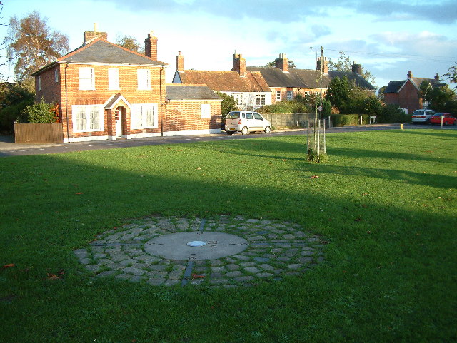
Burton, Dorset. Burton
Village is a lovely self contained village on the edge of the New Forest. Note the compass rose in the foreground.
687:"}},"text\/plain":{"en":{"P973":"https:\/\/www.geograph.org.uk\/photo\/74345"}}}}": -->
947:
710:
604:
560:
230:
843:
730:
265:
1250:
This file contains additional information, probably added from the digital camera or scanner used to create or digitize it.
355:
515:
1066:
1021:
976:
913:
867:
827:
785:
738:
694:
544:
508:
495:
480:
940:
753:
723:
628:
588:
453:
412:
820:"}},"text\/plain":{"en":{"P4082":"Fujifilm FinePix S602 Zoom"}}}}": -->
1197:
1137:
1132:
42:
1395:
311:
1253:
If the file has been modified from its original state, some details may not fully reflect the modified file.
354:– If you remix, transform, or build upon the material, you must distribute your contributions under the
272:
on the
Geograph website for the photographer's contact details. The copyright on this image is owned by
969:"}},"text\/plain":{"en":{"P3575":"118,065 byte"}}}}": -->
446:"}},"text\/plain":{"en":{"P3831":"photographer"}}}}": -->
537:"}},"text\/plain":{"en":{"P6216":"copyrighted"}}}}": -->
1165:
The following pages on the
English Knowledge use this file (pages on other projects are not listed):
1059:"}},"text\/plain":{"en":{"P2049":"640 pixel"}}}}": -->
1014:"}},"text\/plain":{"en":{"P2048":"481 pixel"}}}}": -->
91:
183:
906:"}},"text\/plain":{"en":{"P459":"SHA-1"}}}}": -->
1448:
308:
167:
760:
745:
487:
8:
1484:
252:
236:
1280:
277:
78:
402:
1169:
1544:
1466:
1422:
1287:
1327:
156:
146:
1494:
1076:
1031:
986:
923:
877:
837:
795:
704:
638:
598:
554:
463:
257:
1307:
1237:
269:
1562:
1297:
1270:
1105:
Click on a date/time to view the file as it appeared at that time.
222:
1207:
1217:
1187:
215:
50° 45′ 11″ N, 1° 45′ 54″ W
135:
66:
396:
Add a one-line explanation of what this file represents
1227:
1163:
1178:
1103:
90:
Commons is a freely licensed media file repository.
605:
Creative
Commons Attribution-ShareAlike 2.0 Generic
579:
Creative
Commons Attribution-ShareAlike 2.0 Generic
56:(640 × 481 pixels, file size: 115 KB, MIME type:
1489:Flash did not fire, compulsory flash suppression
365:https://creativecommons.org/licenses/by-sa/2.0
71:
371:Creative Commons Attribution-Share Alike 2.0
289:
131:
113:
152:
141:
116:Burton, Dorset - geograph.org.uk - 74345.jpg
52:Burton,_Dorset_-_geograph.org.uk_-_74345.jpg
14:
1056:
1011:
966:
685:https:\/\/www.geograph.org.uk\/photo\/74345
432:https:\/\/www.geograph.org.uk\/profile\/299
331:– to copy, distribute and transmit the work
1180:The following other wikis use this file:
1365:Digital Camera FinePix S602 ZOOM Ver1.00
929:2992b1a894884893fd538e1d8a54e2bf2e089759
761:https://www.geograph.org.uk/photo/74345
488:https://www.geograph.org.uk/profile/299
229:View this and other nearby images on:
190:
102:
276:and is licensed for reuse under the
205:
1096:
312:Attribution-Share Alike 2.0 Generic
300:
295:
280:Attribution-ShareAlike 2.0 license.
13:
1248:
1234:Usage on zh-min-nan.wikipedia.org
401:
395:
286:
263:
120:
103:
49:
1587:
1255:
400:
1318:Date and time of data generation
1164:
386:
342:Under the following conditions:
307:This file is licensed under the
299:
294:
288:
256:
235:
221:
70:
31:
21:
383:
121:
46:No higher resolution available.
1292:1/220 sec (0.0045454545454545)
1175:
1100:
711:file available on the internet
661:file available on the internet
382:
264:This image was taken from the
26:
1:
786:coordinates of depicted place
776:coordinates of depicted place
36:
1160:
731:Geograph Britain and Ireland
669:Geograph Britain and Ireland
509:object of statement has role
440:object of statement has role
408:Items portrayed in this file
248:
7:
1520:Focal plane resolution unit
1406:Date and time of digitizing
1245:
10:
1592:
1531:One-chip color area sensor
1224:Usage on www.wikidata.org
1214:Usage on tr.wikipedia.org
1204:Usage on it.wikipedia.org
1194:Usage on fa.wikipedia.org
1184:Usage on cy.wikipedia.org
844:Fujifilm FinePix S602 Zoom
818:Fujifilm FinePix S602 Zoom
356:same or compatible license
196:Stuart Buchan /
177:Stuart Buchan /
110:
105:
1371:File change date and time
1097:
801:50°45'10.8"N, 1°45'54.0"W
16:
1512:Focal plane Y resolution
1504:Focal plane X resolution
739:geograph.org.uk image ID
673:geograph.org.uk image ID
385:
322:
77:This is a file from the
41:
1154:
168:required by the license
134:
81:. Information from its
1572:Subject distance range
1414:Image compression mode
1409:16:49, 4 November 2005
1374:13:54, 5 November 2005
1321:16:49, 4 November 2005
1133:13:55, 30 January 2010
270:this photograph's page
241:50.753000; -1.765000
84:description page there
1458:Maximum land aperture
1345:Horizontal resolution
941:determination method
900:determination method
1379:Y and C positioning
1353:Vertical resolution
1267:Camera manufacturer
337:– to adapt the work
1554:Scene capture type
1549:Auto white balance
496:author name string
436:author name string
1579:
1578:
1281:FinePix S602 ZOOM
1176:Global file usage
1158:
1058:
1013:
968:
589:copyright license
575:copyright license
394:
285:
284:
268:collection. See
246:
245:
203:
202:
171:
99:
98:
79:Wikimedia Commons
32:Global file usage
1583:
1387:Exposure Program
1256:
1145:
1107:
1085:
1040:
995:
950:
945:
763:
758:
754:described at URL
748:
743:
733:
728:
681:described at URL
545:copyright status
531:copyright status
518:
513:
503:
500:
490:
485:
392:
378:
375:
372:
369:
366:
358:as the original.
320:
309:Creative Commons
303:
302:
298:
297:
292:
291:
278:Creative Commons
266:Geograph project
260:
253:
242:
239:
225:
224:
218:
217:
206:
165:
137:
125:
117:
111:
95:
74:
73:
67:
61:
59:
1591:
1590:
1586:
1585:
1584:
1582:
1581:
1580:
1461:3 APEX (f/2.83)
1440:APEX brightness
1244:
1238:Burton (Dorset)
1208:Burton (Dorset)
1174:
1166:
1159:
1151:
1143:
1099:
1098:
1095:
1094:
1093:
1092:
1091:
1090:
1089:
1088:
1086:
1083:
1073:
1072:
1071:
1069:
1050:
1049:
1048:
1047:
1046:
1045:
1044:
1043:
1041:
1038:
1028:
1027:
1026:
1024:
1005:
1004:
1003:
1002:
1001:
1000:
999:
998:
996:
993:
983:
982:
981:
979:
960:
959:
958:
957:
956:
955:
954:
953:
952:
951:
946:
943:
934:
933:
932:
930:
920:
919:
918:
916:
893:
892:
891:
890:
889:
888:
887:
886:
884:
874:
873:
872:
870:
855:
854:
853:
852:
851:
850:
849:
848:
846:
834:
833:
832:
830:
811:
810:
809:
808:
807:
806:
805:
804:
802:
792:
791:
790:
788:
773:
772:
771:
770:
769:
768:
767:
766:
765:
764:
759:
756:
750:
749:
744:
741:
735:
734:
729:
726:
717:
716:
715:
713:
701:
700:
699:
697:
654:
653:
652:
651:
650:
649:
648:
647:
645:
644:4 November 2005
635:
634:
633:
631:
616:
615:
614:
613:
612:
611:
610:
609:
607:
595:
594:
593:
591:
572:
571:
570:
569:
568:
567:
566:
565:
563:
551:
550:
549:
547:
528:
527:
526:
525:
524:
523:
522:
521:
520:
519:
514:
511:
505:
504:
501:
498:
492:
491:
486:
483:
474:
473:
472:
470:
460:
459:
458:
456:
421:
420:
419:
418:
417:
415:
399:
398:
397:
380:
379:
376:
373:
370:
367:
364:
363:
321:
318:
315:
304:
281:
251:
240:
213:
212:
209:Object location
204:
193:
186:
174:
147:geograph.org.uk
136:4 November 2005
127:
115:
108:
101:
100:
89:
88:
87:is shown below.
63:
57:
55:
48:
47:
12:
11:
5:
1589:
1577:
1576:
1573:
1569:
1568:
1565:
1559:
1558:
1555:
1551:
1550:
1547:
1541:
1540:
1537:
1533:
1532:
1529:
1528:Sensing method
1525:
1524:
1521:
1517:
1516:
1513:
1509:
1508:
1505:
1501:
1500:
1497:
1491:
1490:
1487:
1481:
1480:
1477:
1473:
1472:
1469:
1463:
1462:
1459:
1455:
1454:
1451:
1445:
1444:
1441:
1437:
1436:
1433:
1429:
1428:
1425:
1419:
1418:
1415:
1411:
1410:
1407:
1403:
1402:
1399:
1392:
1391:
1390:Normal program
1388:
1384:
1383:
1380:
1376:
1375:
1372:
1368:
1367:
1362:
1358:
1357:
1354:
1350:
1349:
1346:
1342:
1341:
1338:
1334:
1333:
1330:
1323:
1322:
1319:
1315:
1314:
1311:
1304:
1303:
1300:
1294:
1293:
1290:
1284:
1283:
1278:
1274:
1273:
1268:
1264:
1263:
1260:
1247:
1243:
1242:
1241:
1240:
1232:
1231:
1230:
1222:
1221:
1220:
1218:Burton, Dorset
1212:
1211:
1210:
1202:
1201:
1200:
1192:
1191:
1190:
1188:Burton, Dorset
1177:
1173:
1172:
1170:Burton, Dorset
1162:
1157:
1156:
1153:
1149:
1146:
1140:
1135:
1130:
1126:
1125:
1122:
1119:
1116:
1113:
1110:
1102:
1087:
1081:
1079:
1078:
1077:
1075:
1074:
1070:
1065:
1063:
1062:
1061:
1060:
1054:
1042:
1036:
1034:
1033:
1032:
1030:
1029:
1025:
1020:
1018:
1017:
1016:
1015:
1009:
997:
991:
989:
988:
987:
985:
984:
980:
975:
973:
972:
971:
970:
964:
939:
938:
937:
936:
935:
931:
928:
926:
925:
924:
922:
921:
917:
912:
910:
909:
908:
907:
905:
901:
897:
885:
882:
880:
879:
878:
876:
875:
871:
866:
864:
863:
862:
861:
859:
847:
842:
840:
839:
838:
836:
835:
831:
826:
824:
823:
822:
821:
819:
815:
803:
800:
798:
797:
796:
794:
793:
789:
784:
782:
781:
780:
779:
777:
752:
751:
737:
736:
722:
721:
720:
719:
718:
714:
709:
707:
706:
705:
703:
702:
698:
695:source of file
693:
691:
690:
689:
688:
686:
682:
678:
674:
670:
666:
662:
658:
657:source of file
646:
643:
641:
640:
639:
637:
636:
632:
627:
625:
624:
623:
622:
620:
608:
603:
601:
600:
599:
597:
596:
592:
587:
585:
584:
583:
582:
580:
576:
564:
559:
557:
556:
555:
553:
552:
548:
543:
541:
540:
539:
538:
536:
532:
507:
506:
494:
493:
479:
478:
477:
476:
475:
471:
468:
466:
465:
464:
462:
461:
457:
452:
450:
449:
448:
447:
445:
441:
437:
433:
429:
425:
416:
411:
409:
406:
405:
404:
403:
391:
390:
387:
384:
362:
361:
360:
359:
349:
340:
339:
338:
332:
325:You are free:
316:
306:
305:
287:
283:
282:
261:
250:
247:
244:
243:
233:
227:
210:
201:
200:
198:Burton, Dorset
194:
191:
188:
187:
182:
179:Burton, Dorset
175:
172:
160:
159:
154:
150:
149:
143:
139:
138:
133:
129:
128:
118:
109:
107:
104:
97:
96:
75:
65:
64:
45:
40:
39:
34:
29:
24:
19:
9:
6:
4:
3:
2:
1588:
1574:
1571:
1570:
1566:
1564:
1561:
1560:
1556:
1553:
1552:
1548:
1546:
1545:White balance
1543:
1542:
1539:Auto exposure
1538:
1536:Exposure mode
1535:
1534:
1530:
1527:
1526:
1522:
1519:
1518:
1514:
1511:
1510:
1506:
1503:
1502:
1498:
1496:
1493:
1492:
1488:
1486:
1483:
1482:
1478:
1475:
1474:
1470:
1468:
1467:Metering mode
1465:
1464:
1460:
1457:
1456:
1452:
1450:
1449:Exposure bias
1447:
1446:
1442:
1439:
1438:
1434:
1432:APEX aperture
1431:
1430:
1426:
1424:
1423:Shutter speed
1421:
1420:
1416:
1413:
1412:
1408:
1405:
1404:
1400:
1397:
1394:
1393:
1389:
1386:
1385:
1381:
1378:
1377:
1373:
1370:
1369:
1366:
1363:
1361:Software used
1360:
1359:
1355:
1352:
1351:
1347:
1344:
1343:
1339:
1336:
1335:
1331:
1329:
1325:
1324:
1320:
1317:
1316:
1312:
1309:
1306:
1305:
1301:
1299:
1296:
1295:
1291:
1289:
1288:Exposure time
1286:
1285:
1282:
1279:
1276:
1275:
1272:
1269:
1266:
1265:
1261:
1258:
1257:
1254:
1251:
1239:
1236:
1235:
1233:
1229:
1226:
1225:
1223:
1219:
1216:
1215:
1213:
1209:
1206:
1205:
1203:
1199:
1196:
1195:
1193:
1189:
1186:
1185:
1183:
1182:
1181:
1171:
1168:
1167:
1152:
1147:
1141:
1139:
1136:
1134:
1131:
1128:
1127:
1123:
1120:
1117:
1114:
1111:
1109:
1108:
1106:
1080:
1068:
1064:
1035:
1023:
1019:
990:
978:
974:
949:
942:
927:
915:
911:
881:
869:
865:
845:
841:
829:
828:captured with
825:
814:captured with
799:
787:
783:
762:
755:
747:
740:
732:
725:
712:
708:
696:
692:
642:
630:
626:
606:
602:
590:
586:
562:
558:
546:
542:
517:
510:
502:Stuart Buchan
497:
489:
482:
467:
455:
451:
414:
410:
407:
388:
381:
368:CC BY-SA 2.0
357:
353:
350:
347:
344:
343:
341:
336:
333:
330:
327:
326:
324:
323:
319:Stuart Buchan
317:Attribution:
313:
310:
293:
279:
275:
274:Stuart Buchan
271:
267:
262:
259:
255:
254:
238:
234:
232:
231:OpenStreetMap
228:
226:
216:
211:
208:
207:
199:
195:
189:
185:
181: /
180:
176:
169:
164:
162:
161:
158:
157:Stuart Buchan
155:
151:
148:
144:
140:
130:
124:
119:
112:
93:
86:
85:
80:
76:
69:
68:
62:
53:
44:
38:
35:
33:
30:
28:
25:
23:
20:
18:
15:
1575:Distant view
1476:Light source
1328:focal length
1277:Camera model
1252:
1249:
1198:برتون، دورست
1179:
1104:
1101:File history
516:photographer
444:photographer
351:
345:
334:
328:
273:
197:
184:CC BY-SA 2.0
178:
122:
92:You can help
82:
50:
22:File history
1495:Color space
1337:Orientation
1259:Image title
1150:GeographBot
561:copyrighted
535:copyrighted
352:share alike
346:attribution
163:Attribution
114:Description
1161:File usage
1142:640 × 481
1118:Dimensions
883:image/jpeg
868:media type
858:media type
469:some value
58:image/jpeg
27:File usage
1563:Sharpness
1308:ISO speed
1115:Thumbnail
1112:Date/Time
977:data size
963:data size
629:inception
619:inception
249:Licensing
192:InfoField
173:InfoField
123:English:
1557:Standard
1382:Co-sited
1298:F-number
1271:FUJIFILM
1246:Metadata
1228:Q2080049
1144:(115 KB)
992:118,065
914:checksum
896:checksum
724:operator
665:operator
389:Captions
335:to remix
329:to share
314:license.
37:Metadata
1479:Unknown
1471:Pattern
1398:version
1262:SZ 1792
1129:current
1124:Comment
454:creator
424:creator
413:depicts
393:English
106:Summary
54:
1567:Normal
1356:72 dpi
1348:72 dpi
1340:Normal
1332:7.8 mm
1310:rating
1022:height
1008:height
219:
153:Author
142:Source
1515:3,704
1507:3,704
1485:Flash
1326:Lens
1084:pixel
1067:width
1057:pixel
1053:width
1039:pixel
1012:pixel
948:SHA-1
904:SHA-1
746:74345
677:74345
145:From
1499:sRGB
1443:5.76
1396:Exif
1121:User
1082:640
1037:481
994:byte
967:byte
377:true
374:true
132:Date
17:File
1427:7.8
1417:1.5
1401:2.2
1313:200
1302:f/4
481:URL
428:URL
944::
757::
742::
727::
512::
499::
484::
1523:3
1453:0
1435:4
170:)
166:(
94:.
60:)
_&language=en)
