844:"}},"text\/plain":{"en":{"":"coordinates of the point of view"}}},"{\"value\":{\"latitude\":55.03961,\"longitude\":-7.3761,\"altitude\":null,\"precision\":1.0e-5,\"globe\":\"http:\\\/\\\/www.wikidata.org\\\/entity\\\/Q2\"},\"type\":\"globecoordinate\"}":{"text\/html":{"en":{"P1259":"55\u00b02'22.60"N, 7\u00b022'33.96"W"}},"text\/plain":{"en":{"P1259":"55\u00b02'22.60\"N, 7\u00b022'33.96\"W"}}},"{\"value\":{\"entity-type\":\"property\",\"numeric-id\":7787,\"id\":\"P7787\"},\"type\":\"wikibase-entityid\"}":{"text\/html":{"en":{"":"
956:"}},"text\/plain":{"en":{"":"coordinates of depicted place"}}},"{\"value\":{\"latitude\":55.0398,\"longitude\":-7.3767,\"altitude\":null,\"precision\":1.0e-5,\"globe\":\"http:\\\/\\\/www.wikidata.org\\\/entity\\\/Q2\"},\"type\":\"globecoordinate\"}":{"text\/html":{"en":{"P9149":"55\u00b02'23.28"N, 7\u00b022'36.12"W"}},"text\/plain":{"en":{"P9149":"55\u00b02'23.28\"N, 7\u00b022'36.12\"W"}}},"{\"value\":{\"entity-type\":\"property\",\"numeric-id\":7787,\"id\":\"P7787\"},\"type\":\"wikibase-entityid\"}":{"text\/html":{"en":{"":"
1272:"}},"text\/plain":{"en":{"":"checksum"}}},"{\"value\":\"095f4136475133287b48b7b286025126a3cdc354\",\"type\":\"string\"}":{"text\/html":{"en":{"P4092":"095f4136475133287b48b7b286025126a3cdc354"}},"text\/plain":{"en":{"P4092":"095f4136475133287b48b7b286025126a3cdc354"}}},"{\"value\":{\"entity-type\":\"property\",\"numeric-id\":459,\"id\":\"P459\"},\"type\":\"wikibase-entityid\"}":{"text\/html":{"en":{"":"
687:"}},"text\/plain":{"en":{"":"inception"}}},"{\"value\":{\"time\":\"+2007-07-26T00:00:00Z\",\"timezone\":0,\"before\":0,\"after\":0,\"precision\":11,\"calendarmodel\":\"http:\\\/\\\/www.wikidata.org\\\/entity\\\/Q1985727\"},\"type\":\"time\"}":{"text\/html":{"en":{"P571":"26 July 2007"}},"text\/plain":{"en":{"P571":"26 July 2007"}}}}": -->
721:
289:
239:
281:
231:
1268:
253:
324:
362:
367:
72:
1152:"}},"text\/plain":{"en":{"":"ISO speed"}}},"{\"value\":{\"amount\":\"+400\",\"unit\":\"1\"},\"type\":\"quantity\"}":{"text\/html":{"en":{"P6789":"400"}},"text\/plain":{"en":{"P6789":"400"}}}}": -->
1069:"}},"text\/plain":{"en":{"":"f-number"}}},"{\"value\":{\"amount\":\"+9.5\",\"unit\":\"1\"},\"type\":\"quantity\"}":{"text\/html":{"en":{"P6790":"9.5"}},"text\/plain":{"en":{"P6790":"9.5"}}}}": -->
1024:"}},"text\/plain":{"en":{"":"exposure time"}}},"{\"value\":{\"amount\":\"+0.00285714285714285714\",\"unit\":\"http:\\\/\\\/www.wikidata.org\\\/entity\\\/Q11574\"},\"type\":\"quantity\"}":{"text\/html":{"en":{"P6757":"0.00285714285714285714
508:"}},"text\/plain":{"en":{"P2699":"https:\/\/www.geograph.org.uk\/profile\/15821"}}},"{\"value\":{\"entity-type\":\"property\",\"numeric-id\":2093,\"id\":\"P2093\"},\"type\":\"wikibase-entityid\"}":{"text\/html":{"en":{"":"
737:"}},"text\/plain":{"en":{"P973":"https:\/\/www.geograph.org.uk\/photo\/505874"}}},"{\"value\":{\"entity-type\":\"property\",\"numeric-id\":7384,\"id\":\"P7384\"},\"type\":\"wikibase-entityid\"}":{"text\/html":{"en":{"":"
512:"}},"text\/plain":{"en":{"":"author name string"}}},"{\"value\":\"Shane Killen\",\"type\":\"string\"}":{"text\/html":{"en":{"P2093":"Shane Killen"}},"text\/plain":{"en":{"P2093":"Shane Killen"}}}}": -->
729:"}},"text\/plain":{"en":{"P7482":"file available on the internet"}}},"{\"value\":{\"entity-type\":\"property\",\"numeric-id\":973,\"id\":\"P973\"},\"type\":\"wikibase-entityid\"}":{"text\/html":{"en":{"":"
496:"}},"text\/plain":{"en":{"":"object of statement has role"}}},"{\"value\":{\"entity-type\":\"item\",\"numeric-id\":33231,\"id\":\"Q33231\"},\"type\":\"wikibase-entityid\"}":{"text\/html":{"en":{"P3831":"
1276:"}},"text\/plain":{"en":{"":"determination method"}}},"{\"value\":{\"entity-type\":\"item\",\"numeric-id\":13414952,\"id\":\"Q13414952\"},\"type\":\"wikibase-entityid\"}":{"text\/html":{"en":{"P459":"
1190:"}},"text\/plain":{"en":{"":"media type"}}},"{\"value\":\"image\\\/jpeg\",\"type\":\"string\"}":{"text\/html":{"en":{"P1163":"image\/jpeg"}},"text\/plain":{"en":{"P1163":"image\/jpeg"}}}}": -->
643:"}},"text\/plain":{"en":{"":"copyright license"}}},"{\"value\":{\"entity-type\":\"item\",\"numeric-id\":19068220,\"id\":\"Q19068220\"},\"type\":\"wikibase-entityid\"}":{"text\/html":{"en":{"P275":"
599:"}},"text\/plain":{"en":{"":"copyright status"}}},"{\"value\":{\"entity-type\":\"item\",\"numeric-id\":50423863,\"id\":\"Q50423863\"},\"type\":\"wikibase-entityid\"}":{"text\/html":{"en":{"P6216":"
725:"}},"text\/plain":{"en":{"":"source of file"}}},"{\"value\":{\"entity-type\":\"item\",\"numeric-id\":74228490,\"id\":\"Q74228490\"},\"type\":\"wikibase-entityid\"}":{"text\/html":{"en":{"P7482":"
1339:"}},"text\/plain":{"en":{"":"data size"}}},"{\"value\":{\"amount\":\"+74148\",\"unit\":\"http:\\\/\\\/www.wikidata.org\\\/entity\\\/Q8799\"},\"type\":\"quantity\"}":{"text\/html":{"en":{"P3575":"74,148
1107:"}},"text\/plain":{"en":{"":"focal length"}}},"{\"value\":{\"amount\":\"+17\",\"unit\":\"http:\\\/\\\/www.wikidata.org\\\/entity\\\/Q174789\"},\"type\":\"quantity\"}":{"text\/html":{"en":{"P2151":"17
500:"}},"text\/plain":{"en":{"P3831":"photographer"}}},"{\"value\":{\"entity-type\":\"property\",\"numeric-id\":2699,\"id\":\"P2699\"},\"type\":\"wikibase-entityid\"}":{"text\/html":{"en":{"":"
912:"}},"text\/plain":{"en":{"":"captured with"}}},"{\"value\":{\"entity-type\":\"item\",\"numeric-id\":64072,\"id\":\"Q64072\"},\"type\":\"wikibase-entityid\"}":{"text\/html":{"en":{"P4082":"
1384:"}},"text\/plain":{"en":{"":"height"}}},"{\"value\":{\"amount\":\"+261\",\"unit\":\"http:\\\/\\\/www.wikidata.org\\\/entity\\\/Q355198\"},\"type\":\"quantity\"}":{"text\/html":{"en":{"P2048":"261
1228:"}},"text\/plain":{"en":{"":"instance of"}}},"{\"value\":{\"entity-type\":\"item\",\"numeric-id\":125191,\"id\":\"Q125191\"},\"type\":\"wikibase-entityid\"}":{"text\/html":{"en":{"P31":"
960:"}},"text\/plain":{"en":{"":"heading"}}},"{\"value\":{\"amount\":\"+292\",\"unit\":\"http:\\\/\\\/www.wikidata.org\\\/entity\\\/Q28390\"},\"type\":\"quantity\"}":{"text\/html":{"en":{"P7787":"292
848:"}},"text\/plain":{"en":{"":"heading"}}},"{\"value\":{\"amount\":\"+292\",\"unit\":\"http:\\\/\\\/www.wikidata.org\\\/entity\\\/Q28390\"},\"type\":\"quantity\"}":{"text\/html":{"en":{"P7787":"292
749:"}},"text\/plain":{"en":{"":"operator"}}},"{\"value\":{\"entity-type\":\"item\",\"numeric-id\":1503119,\"id\":\"Q1503119\"},\"type\":\"wikibase-entityid\"}":{"text\/html":{"en":{"P137":"
1429:"}},"text\/plain":{"en":{"":"width"}}},"{\"value\":{\"amount\":\"+640\",\"unit\":\"http:\\\/\\\/www.wikidata.org\\\/entity\\\/Q355198\"},\"type\":\"quantity\"}":{"text\/html":{"en":{"P2049":"640
1512:
745:"}},"text\/plain":{"en":{"P7384":"505874"}}},"{\"value\":{\"entity-type\":\"property\",\"numeric-id\":137,\"id\":\"P137\"},\"type\":\"wikibase-entityid\"}":{"text\/html":{"en":{"":"
492:"}},"text\/plain":{"en":{"":"creator"}}},"{\"value\":{\"entity-type\":\"property\",\"numeric-id\":3831,\"id\":\"P3831\"},\"type\":\"wikibase-entityid\"}":{"text\/html":{"en":{"":"
1425:
272:
741:"}},"text\/plain":{"en":{"":"geograph.org.uk image ID"}}},"{\"value\":\"505874\",\"type\":\"string\"}":{"text\/html":{"en":{"P7384":"
222:
1529:== {{int:filedesc}} == {{Information |description={{en|1=Bridge End Co. Donegal Three petrol stations just over the UK/Eire border. Unlike petrol stations on the UK side these three stations are thriving due to the difference in fuel tax/Euro exchange rat
126:
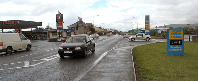
Bridge End Co. Donegal. Three petrol stations just over the UK/Eire border. Unlike petrol stations on the UK side these three stations are thriving due to the difference in fuel tax/Euro exchange rate. Compare the fate of the petrol station at C4120 (
414:– You must give appropriate credit, provide a link to the license, and indicate if changes were made. You may do so in any reasonable manner, but not in any way that suggests the licensor endorses you or your use.
236:
286:
83:
51:
1277:
742:
726:
644:
600:
750:
1229:
913:
497:
1426:
1381:
1336:
1269:
1187:
1149:
1104:
1066:
1021:
957:
953:
909:
845:
841:
738:
722:
596:
509:
501:
493:
505:
1273:
746:
734:
730:
684:
640:
489:
1225:
1522:
128:
1621:
1601:
647:"}},"text\/plain":{"en":{"P275":"Creative Commons Attribution-ShareAlike 2.0 Generic"}}}}": -->
1321:
776:
670:
626:
296:
246:
826:
331:
1644:
This file contains additional information, probably added from the digital camera or scanner used to create or digitize it.
1255:
421:
939:
553:
1440:
1395:
1350:
1287:
1197:
1159:
1118:
1076:
1035:
998:
971:
923:
886:
859:
804:
760:
610:
576:
561:
546:
1511:
1506:
1028:"}},"text\/plain":{"en":{"P6757":"0.00285714285714285714 second"}}}}": -->
42:
1314:
819:
789:
694:
654:
519:
478:
753:"}},"text\/plain":{"en":{"P137":"Geograph Britain and Ireland"}}}}": -->
1239:
1771:
377:
1647:
If the file has been modified from its original state, some details may not fully reflect the modified file.
916:"}},"text\/plain":{"en":{"P4082":"Canon EOS 350D"}}}}": -->
420:– If you remix, transform, or build upon the material, you must distribute your contributions under the
338:
on the
Geograph website for the photographer's contact details. The copyright on this image is owned by
1666:
1111:"}},"text\/plain":{"en":{"P2151":"17 millimetre"}}}}": -->
1343:"}},"text\/plain":{"en":{"P3575":"74,148 byte"}}}}": -->
603:"}},"text\/plain":{"en":{"P6216":"copyrighted"}}}}": -->
1539:
The following pages on the
English Knowledge use this file (pages on other projects are not listed):
964:"}},"text\/plain":{"en":{"P7787":"292 degree"}}}}": -->
852:"}},"text\/plain":{"en":{"P7787":"292 degree"}}}}": -->
1543:
1433:"}},"text\/plain":{"en":{"P2049":"640 pixel"}}}}": -->
1388:"}},"text\/plain":{"en":{"P2048":"261 pixel"}}}}": -->
1232:"}},"text\/plain":{"en":{"P31":"photograph"}}}}": -->
91:
191:
1280:"}},"text\/plain":{"en":{"P459":"SHA-1"}}}}": -->
1808:
568:
811:
796:
374:
175:
8:
1828:
318:
302:
252:
343:
78:
468:
1656:
1888:
1818:
1790:
1673:
164:
1713:
154:
1450:
1405:
1360:
1297:
1249:
1207:
1169:
1128:
1086:
1045:
981:
933:
869:
770:
704:
664:
620:
529:
1838:
323:
132:
1693:
335:
1683:
1479:
Click on a date/time to view the file as it appeared at that time.
288:
238:
1611:
1581:
1591:
273:
55° 02′ 23″ N, 7° 22′ 36″ W
223:
55° 02′ 23″ N, 7° 22′ 34″ W
143:
66:
1561:
1571:
462:
Add a one-line explanation of what this file represents
1631:
1537:
116:
Bridge End Co. Donegal - geograph.org.uk - 505874.jpg
52:
Bridge_End_Co._Donegal_-_geograph.org.uk_-_505874.jpg
1552:
1477:
90:
Commons is a freely licensed media file repository.
671:
Creative
Commons Attribution-ShareAlike 2.0 Generic
645:
Creative
Commons Attribution-ShareAlike 2.0 Generic
1833:Flash did not fire, compulsory flash suppression
56:(640 × 261 pixels, file size: 72 KB, MIME type:
431:https://creativecommons.org/licenses/by-sa/2.0
71:
506:https:\/\/www.geograph.org.uk\/profile\/15821
437:Creative Commons Attribution-Share Alike 2.0
355:
139:
113:
735:https:\/\/www.geograph.org.uk\/photo\/505874
160:
149:
14:
1430:
1385:
1340:
1108:
1025:
961:
849:
397:– to copy, distribute and transmit the work
1554:The following other wikis use this file:
569:https://www.geograph.org.uk/profile/15821
1303:095f4136475133287b48b7b286025126a3cdc354
797:https://www.geograph.org.uk/photo/505874
295:View this and other nearby images on:
245:View this and other nearby images on:
198:
133:https://www.panoramio.com/user/574636
102:
342:and is licensed for reuse under the
263:
213:
1470:
378:Attribution-Share Alike 2.0 Generic
366:
361:
346:Attribution-ShareAlike 2.0 license.
13:
1642:
467:
461:
352:
329:
120:
103:
49:
1913:
1649:
466:
1704:Date and time of data generation
1538:
860:coordinates of the point of view
842:coordinates of the point of view
452:
408:Under the following conditions:
373:This file is licensed under the
365:
360:
354:
322:
301:
287:
279:
251:
237:
229:
70:
31:
21:
449:
131:) about 2Km to the South East.
121:
46:No higher resolution available.
1678:1/350 sec (0.0028571428571429)
1549:
1474:
777:file available on the internet
727:file available on the internet
448:
330:This image was taken from the
26:
1:
972:coordinates of depicted place
954:coordinates of depicted place
36:
1534:
827:Geograph Britain and Ireland
751:Geograph Britain and Ireland
547:object of statement has role
494:object of statement has role
474:Items portrayed in this file
314:
278:
228:
7:
1864:Focal plane resolution unit
1782:Date and time of digitizing
1639:
1558:Usage on ceb.wikipedia.org
10:
1918:
1667:Canon EOS DIGITAL REBEL XT
1628:Usage on www.wikidata.org
1618:Usage on uk.wikipedia.org
1608:Usage on sv.wikipedia.org
1598:Usage on ru.wikipedia.org
1588:Usage on ga.wikipedia.org
1578:Usage on eu.wikipedia.org
1568:Usage on es.wikipedia.org
987:55°2'23.28"N, 7°22'36.12"W
875:55°2'22.60"N, 7°22'33.96"W
422:same or compatible license
110:
105:
1747:File change date and time
1471:
204:Shane Killen /
185:Shane Killen /
16:
1856:Focal plane Y resolution
1848:Focal plane X resolution
1544:Bridgend, County Donegal
805:geograph.org.uk image ID
739:geograph.org.uk image ID
451:
388:
77:This is a file from the
41:
1872:Custom image processing
1528:
1051:0.00285714285714285714
176:required by the license
142:
81:. Information from its
1507:07:51, 5 February 2011
336:this photograph's page
307:55.039800; -7.376700
257:55.039610; -7.376100
206:Bridge End Co. Donegal
187:Bridge End Co. Donegal
84:description page there
1731:Horizontal resolution
1315:determination method
1274:determination method
1785:12:09, 26 July 2007
1755:Y and C positioning
1750:12:31, 26 July 2007
1739:Vertical resolution
1707:12:09, 26 July 2007
1653:Camera manufacturer
1622:Брідженд (Ірландія)
1602:Бридженд (Ирландия)
403:– to adapt the work
1898:Scene capture type
1893:Auto white balance
1612:Bridge End, Irland
1582:Bridgend (Donegal)
577:author name string
510:author name string
1905:
1904:
1592:Ceann an Droichid
1550:Global file usage
1532:
1432:
1387:
1342:
1110:
1027:
963:
851:
655:copyright license
641:copyright license
460:
351:
350:
334:collection. See
312:
311:
262:
261:
211:
210:
179:
99:
98:
79:Wikimedia Commons
32:Global file usage
1909:
1859:3,958.7628865979
1763:Exposure Program
1650:
1519:
1481:
1459:
1414:
1369:
1324:
1319:
1137:
1054:
1009:
1008:
1003:
897:
896:
891:
829:
824:
814:
809:
799:
794:
790:described at URL
731:described at URL
611:copyright status
597:copyright status
584:
581:
571:
566:
556:
551:
458:
444:
441:
438:
435:
432:
424:as the original.
386:
375:Creative Commons
369:
368:
364:
363:
358:
357:
344:Creative Commons
332:Geograph project
326:
319:
308:
305:
291:
290:
284:
283:
282:
276:
275:
264:
258:
255:
241:
240:
234:
233:
232:
226:
225:
214:
173:
145:
125:
117:
111:
95:
74:
73:
67:
61:
59:
1917:
1916:
1912:
1911:
1910:
1908:
1907:
1906:
1851:3,954.233409611
1795:8.4512176513672
1638:
1548:
1540:
1533:
1525:
1517:
1473:
1472:
1469:
1468:
1467:
1466:
1465:
1464:
1463:
1462:
1460:
1457:
1447:
1446:
1445:
1443:
1424:
1423:
1422:
1421:
1420:
1419:
1418:
1417:
1415:
1412:
1402:
1401:
1400:
1398:
1379:
1378:
1377:
1376:
1375:
1374:
1373:
1372:
1370:
1367:
1357:
1356:
1355:
1353:
1334:
1333:
1332:
1331:
1330:
1329:
1328:
1327:
1326:
1325:
1320:
1317:
1308:
1307:
1306:
1304:
1294:
1293:
1292:
1290:
1267:
1266:
1265:
1264:
1263:
1262:
1261:
1260:
1258:
1246:
1245:
1244:
1242:
1223:
1222:
1221:
1220:
1219:
1218:
1217:
1216:
1214:
1204:
1203:
1202:
1200:
1185:
1184:
1183:
1182:
1181:
1180:
1179:
1178:
1176:
1166:
1165:
1164:
1162:
1147:
1146:
1145:
1144:
1143:
1142:
1141:
1140:
1138:
1135:
1125:
1124:
1123:
1121:
1102:
1101:
1100:
1099:
1098:
1097:
1096:
1095:
1093:
1083:
1082:
1081:
1079:
1064:
1063:
1062:
1061:
1060:
1059:
1058:
1057:
1055:
1052:
1042:
1041:
1040:
1038:
1019:
1018:
1017:
1016:
1015:
1014:
1013:
1012:
1011:
1010:
1006:
1004:
1001:
992:
991:
990:
988:
978:
977:
976:
974:
951:
950:
949:
948:
947:
946:
945:
944:
942:
930:
929:
928:
926:
907:
906:
905:
904:
903:
902:
901:
900:
899:
898:
894:
892:
889:
880:
879:
878:
876:
866:
865:
864:
862:
839:
838:
837:
836:
835:
834:
833:
832:
831:
830:
825:
822:
816:
815:
810:
807:
801:
800:
795:
792:
783:
782:
781:
779:
767:
766:
765:
763:
720:
719:
718:
717:
716:
715:
714:
713:
711:
701:
700:
699:
697:
682:
681:
680:
679:
678:
677:
676:
675:
673:
661:
660:
659:
657:
638:
637:
636:
635:
634:
633:
632:
631:
629:
617:
616:
615:
613:
594:
593:
592:
591:
590:
589:
588:
587:
586:
585:
582:
579:
573:
572:
567:
564:
558:
557:
552:
549:
540:
539:
538:
536:
526:
525:
524:
522:
487:
486:
485:
484:
483:
481:
465:
464:
463:
446:
445:
442:
439:
436:
433:
430:
429:
387:
384:
381:
370:
347:
317:
306:
280:
271:
270:
267:Object location
256:
230:
221:
220:
217:Camera location
212:
201:
194:
182:
155:geograph.org.uk
135:
115:
108:
101:
100:
89:
88:
87:is shown below.
63:
57:
55:
48:
47:
12:
11:
5:
1915:
1903:
1902:
1899:
1895:
1894:
1891:
1885:
1884:
1881:
1877:
1876:
1875:Normal process
1873:
1869:
1868:
1865:
1861:
1860:
1857:
1853:
1852:
1849:
1845:
1844:
1841:
1835:
1834:
1831:
1825:
1824:
1821:
1815:
1814:
1811:
1805:
1804:
1803:6.495849609375
1801:
1797:
1796:
1793:
1787:
1786:
1783:
1779:
1778:
1775:
1768:
1767:
1766:Normal program
1764:
1760:
1759:
1756:
1752:
1751:
1748:
1744:
1743:
1740:
1736:
1735:
1732:
1728:
1727:
1724:
1720:
1719:
1716:
1709:
1708:
1705:
1701:
1700:
1697:
1690:
1689:
1686:
1680:
1679:
1676:
1670:
1669:
1664:
1660:
1659:
1654:
1641:
1637:
1636:
1635:
1634:
1626:
1625:
1624:
1616:
1615:
1614:
1606:
1605:
1604:
1596:
1595:
1594:
1586:
1585:
1584:
1576:
1575:
1574:
1566:
1565:
1564:
1551:
1547:
1546:
1536:
1531:
1530:
1527:
1523:
1520:
1514:
1509:
1504:
1500:
1499:
1496:
1493:
1490:
1487:
1484:
1476:
1461:
1455:
1453:
1452:
1451:
1449:
1448:
1444:
1439:
1437:
1436:
1435:
1434:
1428:
1416:
1410:
1408:
1407:
1406:
1404:
1403:
1399:
1394:
1392:
1391:
1390:
1389:
1383:
1371:
1365:
1363:
1362:
1361:
1359:
1358:
1354:
1349:
1347:
1346:
1345:
1344:
1338:
1313:
1312:
1311:
1310:
1309:
1305:
1302:
1300:
1299:
1298:
1296:
1295:
1291:
1286:
1284:
1283:
1282:
1281:
1279:
1275:
1271:
1259:
1254:
1252:
1251:
1250:
1248:
1247:
1243:
1238:
1236:
1235:
1234:
1233:
1231:
1227:
1215:
1212:
1210:
1209:
1208:
1206:
1205:
1201:
1196:
1194:
1193:
1192:
1191:
1189:
1177:
1174:
1172:
1171:
1170:
1168:
1167:
1163:
1158:
1156:
1155:
1154:
1153:
1151:
1139:
1133:
1131:
1130:
1129:
1127:
1126:
1122:
1117:
1115:
1114:
1113:
1112:
1106:
1094:
1091:
1089:
1088:
1087:
1085:
1084:
1080:
1075:
1073:
1072:
1071:
1070:
1068:
1056:
1050:
1048:
1047:
1046:
1044:
1043:
1039:
1034:
1032:
1031:
1030:
1029:
1023:
997:
996:
995:
994:
993:
989:
986:
984:
983:
982:
980:
979:
975:
970:
968:
967:
966:
965:
959:
955:
943:
940:Canon EOS 350D
938:
936:
935:
934:
932:
931:
927:
922:
920:
919:
918:
917:
915:
914:Canon EOS 350D
911:
885:
884:
883:
882:
881:
877:
874:
872:
871:
870:
868:
867:
863:
858:
856:
855:
854:
853:
847:
843:
818:
817:
803:
802:
788:
787:
786:
785:
784:
780:
775:
773:
772:
771:
769:
768:
764:
761:source of file
759:
757:
756:
755:
754:
752:
748:
744:
740:
736:
732:
728:
724:
723:source of file
712:
709:
707:
706:
705:
703:
702:
698:
693:
691:
690:
689:
688:
686:
674:
669:
667:
666:
665:
663:
662:
658:
653:
651:
650:
649:
648:
646:
642:
630:
625:
623:
622:
621:
619:
618:
614:
609:
607:
606:
605:
604:
602:
598:
575:
574:
560:
559:
545:
544:
543:
542:
541:
537:
534:
532:
531:
530:
528:
527:
523:
518:
516:
515:
514:
513:
511:
507:
503:
499:
495:
491:
482:
477:
475:
472:
471:
470:
469:
457:
456:
453:
450:
428:
427:
426:
425:
415:
406:
405:
404:
398:
391:You are free:
382:
372:
371:
353:
349:
348:
327:
316:
313:
310:
309:
299:
293:
268:
260:
259:
249:
243:
218:
209:
208:
202:
199:
196:
195:
190:
183:
180:
168:
167:
162:
158:
157:
151:
147:
146:
141:
137:
136:
118:
109:
107:
104:
97:
96:
75:
65:
64:
45:
40:
39:
34:
29:
24:
19:
9:
6:
4:
3:
2:
1914:
1900:
1897:
1896:
1892:
1890:
1889:White balance
1887:
1886:
1883:Auto exposure
1882:
1880:Exposure mode
1879:
1878:
1874:
1871:
1870:
1866:
1863:
1862:
1858:
1855:
1854:
1850:
1847:
1846:
1842:
1840:
1837:
1836:
1832:
1830:
1827:
1826:
1822:
1820:
1819:Metering mode
1817:
1816:
1812:
1810:
1809:Exposure bias
1807:
1806:
1802:
1800:APEX aperture
1799:
1798:
1794:
1792:
1791:Shutter speed
1789:
1788:
1784:
1781:
1780:
1776:
1773:
1770:
1769:
1765:
1762:
1761:
1757:
1754:
1753:
1749:
1746:
1745:
1741:
1738:
1737:
1733:
1730:
1729:
1725:
1722:
1721:
1717:
1715:
1711:
1710:
1706:
1703:
1702:
1698:
1695:
1692:
1691:
1687:
1685:
1682:
1681:
1677:
1675:
1674:Exposure time
1672:
1671:
1668:
1665:
1662:
1661:
1658:
1655:
1652:
1651:
1648:
1645:
1633:
1630:
1629:
1627:
1623:
1620:
1619:
1617:
1613:
1610:
1609:
1607:
1603:
1600:
1599:
1597:
1593:
1590:
1589:
1587:
1583:
1580:
1579:
1577:
1573:
1570:
1569:
1567:
1563:
1560:
1559:
1557:
1556:
1555:
1545:
1542:
1541:
1526:
1521:
1515:
1513:
1510:
1508:
1505:
1502:
1501:
1497:
1494:
1491:
1488:
1485:
1483:
1482:
1480:
1454:
1442:
1438:
1409:
1397:
1393:
1364:
1352:
1348:
1323:
1316:
1301:
1289:
1285:
1257:
1253:
1241:
1237:
1211:
1199:
1195:
1173:
1161:
1157:
1132:
1120:
1116:
1090:
1078:
1074:
1049:
1037:
1036:exposure time
1033:
1022:exposure time
1000:
985:
973:
969:
941:
937:
925:
924:captured with
921:
910:captured with
888:
873:
861:
857:
828:
821:
813:
806:
798:
791:
778:
774:
762:
758:
708:
696:
692:
672:
668:
656:
652:
628:
624:
612:
608:
578:
570:
563:
555:
548:
533:
521:
517:
480:
476:
473:
454:
447:
434:CC BY-SA 2.0
423:
419:
416:
413:
410:
409:
407:
402:
399:
396:
393:
392:
390:
389:
383:Attribution:
379:
376:
359:
345:
341:
337:
333:
328:
325:
321:
320:
304:
300:
298:
297:OpenStreetMap
294:
292:
274:
269:
266:
265:
254:
250:
248:
247:OpenStreetMap
244:
242:
224:
219:
216:
215:
207:
203:
197:
193:
189: /
188:
184:
177:
172:
170:
169:
166:
163:
159:
156:
152:
148:
138:
134:
130:
124:
119:
112:
93:
86:
85:
80:
76:
69:
68:
62:
53:
44:
38:
35:
33:
30:
28:
25:
23:
20:
18:
15:
1714:focal length
1663:Camera model
1646:
1643:
1553:
1478:
1475:File history
1119:focal length
1105:focal length
710:26 July 2007
583:Shane Killen
554:photographer
498:photographer
417:
411:
400:
394:
385:Shane Killen
340:Shane Killen
339:
277:
227:
205:
192:CC BY-SA 2.0
186:
165:Shane Killen
144:26 July 2007
122:
92:You can help
82:
50:
22:File history
1839:Color space
1723:Orientation
1524:GeographBot
1240:instance of
1226:instance of
627:copyrighted
601:copyrighted
418:share alike
412:attribution
171:Attribution
114:Description
1572:Bridge End
1562:Bridge End
1535:File usage
1516:640 × 261
1492:Dimensions
1256:photograph
1230:photograph
1213:image/jpeg
1198:media type
1188:media type
1136:millimetre
1109:millimetre
535:some value
58:image/jpeg
27:File usage
1694:ISO speed
1489:Thumbnail
1486:Date/Time
1351:data size
1337:data size
1160:ISO speed
1150:ISO speed
695:inception
685:inception
315:Licensing
200:InfoField
181:InfoField
123:English:
1901:Standard
1758:Co-sited
1684:F-number
1640:Metadata
1632:Q1249297
1288:checksum
1270:checksum
1077:f-number
1067:f-number
820:operator
747:operator
455:Captions
401:to remix
395:to share
380:license.
37:Metadata
1823:Pattern
1774:version
1518:(72 KB)
1503:current
1498:Comment
1366:74,148
999:heading
958:heading
887:heading
846:heading
520:creator
490:creator
479:depicts
459:English
106:Summary
54:
1867:inches
1742:72 dpi
1734:72 dpi
1726:Normal
1696:rating
1396:height
1382:height
1053:second
1026:second
1007:degree
962:degree
895:degree
850:degree
812:505874
743:505874
285:
235:
161:Author
150:Source
129:505840
1829:Flash
1718:17 mm
1712:Lens
1688:f/9.5
1657:Canon
1458:pixel
1441:width
1431:pixel
1427:width
1413:pixel
1386:pixel
1322:SHA-1
1278:SHA-1
153:From
1843:sRGB
1777:2.21
1772:Exif
1495:User
1456:640
1411:261
1368:byte
1341:byte
1005:292
893:292
443:true
440:true
140:Date
17:File
1699:400
1175:400
1134:17
1092:9.5
562:URL
502:URL
1318::
1002::
890::
823::
808::
793::
580::
565::
550::
1813:0
178:)
174:(
94:.
60:)
Text is available under the Creative Commons Attribution-ShareAlike License. Additional terms may apply.
_heading:292.00&language=en)
_heading:292.00&language=en)
