558:"}},"text\/plain":{"en":{"":"checksum"}}},"{\"value\":\"050524924e1245e51be5250e62e85894ce9b54c9\",\"type\":\"string\"}":{"text\/html":{"en":{"P4092":"050524924e1245e51be5250e62e85894ce9b54c9"}},"text\/plain":{"en":{"P4092":"050524924e1245e51be5250e62e85894ce9b54c9"}}},"{\"value\":{\"entity-type\":\"property\",\"numeric-id\":459,\"id\":\"P459\"},\"type\":\"wikibase-entityid\"}":{"text\/html":{"en":{"":"
482:"}},"text\/plain":{"en":{"":"inception"}}},"{\"value\":{\"time\":\"+2010-11-29T00:00:00Z\",\"timezone\":0,\"before\":0,\"after\":0,\"precision\":11,\"calendarmodel\":\"http:\\\/\\\/www.wikidata.org\\\/entity\\\/Q1985727\"},\"type\":\"time\"}":{"text\/html":{"en":{"P571":"29 November 2010"}},"text\/plain":{"en":{"P571":"29 November 2010"}}}}": -->
38:
242:
554:
253:
94:
562:"}},"text\/plain":{"en":{"":"determination method"}}},"{\"value\":{\"entity-type\":\"item\",\"numeric-id\":13414952,\"id\":\"Q13414952\"},\"type\":\"wikibase-entityid\"}":{"text\/html":{"en":{"P459":"
520:"}},"text\/plain":{"en":{"":"media type"}}},"{\"value\":\"image\\\/jpeg\",\"type\":\"string\"}":{"text\/html":{"en":{"P1163":"image\/jpeg"}},"text\/plain":{"en":{"P1163":"image\/jpeg"}}}}": -->
438:"}},"text\/plain":{"en":{"":"copyright license"}}},"{\"value\":{\"entity-type\":\"item\",\"numeric-id\":14946043,\"id\":\"Q14946043\"},\"type\":\"wikibase-entityid\"}":{"text\/html":{"en":{"P275":"
394:"}},"text\/plain":{"en":{"":"copyright status"}}},"{\"value\":{\"entity-type\":\"item\",\"numeric-id\":50423863,\"id\":\"Q50423863\"},\"type\":\"wikibase-entityid\"}":{"text\/html":{"en":{"P6216":"
625:"}},"text\/plain":{"en":{"":"data size"}}},"{\"value\":{\"amount\":\"+243288\",\"unit\":\"http:\\\/\\\/www.wikidata.org\\\/entity\\\/Q8799\"},\"type\":\"quantity\"}":{"text\/html":{"en":{"P3575":"243,288
670:"}},"text\/plain":{"en":{"":"height"}}},"{\"value\":{\"amount\":\"+1040\",\"unit\":\"http:\\\/\\\/www.wikidata.org\\\/entity\\\/Q355198\"},\"type\":\"quantity\"}":{"text\/html":{"en":{"P2048":"1,040
715:"}},"text\/plain":{"en":{"":"width"}}},"{\"value\":{\"amount\":\"+1999\",\"unit\":\"http:\\\/\\\/www.wikidata.org\\\/entity\\\/Q355198\"},\"type\":\"quantity\"}":{"text\/html":{"en":{"P2049":"1,999
711:
1011:
996:
300:– You must give appropriate credit, provide a link to the license, and indicate if changes were made. You may do so in any reasonable manner, but not in any way that suggests the licensor endorses you or your use.
819:, UK. Equirectangular map projection on WGS 84 datum, with N/S stretched 160% Geographic limits: *West: 1.63W *East: 0.46W *North: 51.59N *South: 51.21N |Source=[[w:Ordnance Survey|Ordnan
563:
439:
395:
1161:
712:
667:
622:
555:
517:
391:
559:
479:
435:
1126:
1325:
933:
60:
56:
52:
48:
42:
928:
105:
73:
442:"}},"text\/plain":{"en":{"P275":"Creative Commons Attribution-ShareAlike 3.0 Unported"}}}}": -->
1116:
340:
231:
1111:
1001:
607:
465:
421:
1286:
307:
883:
726:
681:
636:
573:
527:
405:
1271:
923:
600:
489:
449:
380:
1281:
893:
202:
263:
878:
848:
838:
833:
951:
1306:
306:– If you remix, transform, or build upon the material, you must distribute your contributions under the
1231:
797:
792:
629:"}},"text\/plain":{"en":{"P3575":"243,288 byte"}}}}": -->
64:
37:
719:"}},"text\/plain":{"en":{"P2049":"1,999 pixel"}}}}": -->
674:"}},"text\/plain":{"en":{"P2048":"1,040 pixel"}}}}": -->
398:"}},"text\/plain":{"en":{"P6216":"copyrighted"}}}}": -->
829:
The following pages on the
English Knowledge use this file (pages on other projects are not listed):
903:
863:
1296:
1251:
1226:
185:
113:
888:
843:
1241:
566:"}},"text\/plain":{"en":{"P459":"SHA-1"}}}}": -->
1036:
1021:
991:
868:
1216:
1316:
1106:
1096:
260:
8:
913:
1181:
1151:
1066:
971:
100:
370:
908:
182:
966:
961:
853:
219:
1261:
1246:
1056:
858:
808:
206:
1136:
1171:
1026:
1206:
1191:
981:
918:
898:
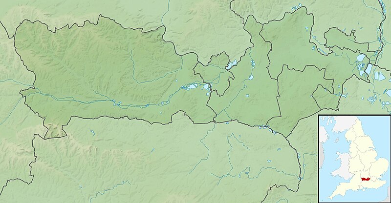
736:
691:
646:
583:
537:
499:
459:
415:
873:
145:
Equirectangular map projection on WGS 84 datum, with N/S stretched 160%
139:
1071:
986:
976:
816:
195:
Administrative borders and coastline data from
Boundary-Line product.
1081:
765:
Click on a date/time to view the file as it appeared at that time.
271:
Contains
Ordnance Survey data © Crown copyright and database right
1061:
1086:
1051:
1046:
1076:
1146:
1287:
Modül:Konum haritası/veri/Birleşik Krallık
Berkshire/belge
1196:
171:
88:
364:
Add a one-line explanation of what this file represents
1252:
Module:Location map/data/United
Kingdom Berkshire/doc
1232:
Module:Location map/data/United
Kingdom Berkshire/doc
934:
Module:Location map/data/United
Kingdom Berkshire/doc
827:
78:(1,999 × 1,040 pixels, file size: 238 KB, MIME type:
1282:
Modül:Konum haritası/veri/Birleşik Krallık
Berkshire
1117:モジュール:Location map/data/United Kingdom Berkshire/doc
942:
763:
466:
Creative
Commons Attribution-ShareAlike 3.0 Unported
440:
Creative
Commons Attribution-ShareAlike 3.0 Unported
112:
Commons is a freely licensed media file repository.
1012:টেমপ্লেট:অবস্থান মানচিত্র United Kingdom Berkshire
198:All other geographic data from Meridian 2 product.
1242:Module:Location map/data/United Kingdom Berkshire
1227:Module:Location map/data/United Kingdom Berkshire
929:Module:Location map/data/United Kingdom Berkshire
1112:モジュール:Location map/data/United Kingdom Berkshire
1127:ಟೆಂಪ್ಲೇಟು:Location map United Kingdom Berkshire
1022:Plantilya:Location map United Kingdom Berkshire
1217:Template:Location map United Kingdom Berkshire
1107:Template:Location map United Kingdom Berkshire
1097:Template:Mappa di localizzazione/GBR Berkshire
317:https://creativecommons.org/licenses/by-sa/3.0
93:
1317:Batakan:Location map United Kingdom Berkshire
1307:Bản mẫu:Location map United Kingdom Berkshire
343:- Blank map with administrative borders only.
323:Creative Commons Attribution-Share Alike 3.0
241:
226:
167:
130:
1272:Шаблон:Location map United Kingdom Berkshire
336:
215:
192:Relief data from Land-Form Panorama product.
177:
14:
1037:Plantilla:Mapa de localización de Berkshire
716:
671:
626:
283:– to copy, distribute and transmit the work
952:قالب:Location map United Kingdom Berkshire
341:File:Berkshire UK district map (blank).svg
944:The following other wikis use this file:
815:{{Information |Description=Relief map of
589:050524924e1245e51be5250e62e85894ce9b54c9
124:
884:MDIS & Partners Festival of Golf
264:Attribution-Share Alike 3.0 Unported
222:, created using Ordnance Survey data
133:Berkshire UK relief location map.jpg
1262:Mall:Kartposition England Berkshire
756:
252:
247:
13:
1247:Module:Location map/data/Berkshire
924:Module:Location map/data/Berkshire
369:
363:
238:
125:
71:
1337:
1137:Formula:Charta locatrix Berceriae
368:
1067:Modèle:Géolocalisation/Berkshire
997:Шаблон:ПК Великобритания Бъркшър
828:
354:
294:Under the following conditions:
259:This file is licensed under the
251:
246:
240:
92:
31:
21:
1172:Sjabloon:Positiekaart Berkshire
894:River Blackwater (River Loddon)
351:
1223:Usage on simple.wikipedia.org
1027:Wokingham (kapital sa kondado)
939:
760:
350:
26:
1:
1057:Utilisateur:Ælfgar/Brouillon3
879:Jewish Community of Berkshire
849:2021 Senior Open Championship
839:2015 Senior Open Championship
834:2009 Senior Open Championship
1297:سانچہ:Location map Berkshire
824:
376:Items portrayed in this file
7:
1313:Usage on war.wikipedia.org
1213:Usage on sco.wikipedia.org
1152:Veidne:VietasKarte Bārkšīra
1018:Usage on ceb.wikipedia.org
10:
1342:
1303:Usage on vi.wikipedia.org
1293:Usage on ur.wikipedia.org
1278:Usage on tr.wikipedia.org
1268:Usage on tg.wikipedia.org
1258:Usage on sv.wikipedia.org
1238:Usage on si.wikipedia.org
1203:Usage on pl.wikibooks.org
1188:Usage on pl.wikipedia.org
1178:Usage on os.wikipedia.org
1168:Usage on nl.wikipedia.org
1158:Usage on mk.wikipedia.org
1143:Usage on lv.wikipedia.org
1133:Usage on la.wikipedia.org
1123:Usage on kn.wikipedia.org
1103:Usage on ja.wikipedia.org
1093:Usage on it.wikipedia.org
1082:Bataille d'Englefield
1043:Usage on fr.wikipedia.org
1033:Usage on es.wikipedia.org
1008:Usage on bn.wikipedia.org
958:Usage on bg.wikipedia.org
948:Usage on ar.wikipedia.org
308:same or compatible license
127:
1207:Moduł:Mapa/dane/Berkshire
1192:Moduł:Mapa/dane/Berkshire
757:
16:
1072:Kennet Valley Alderwoods
904:Second Battle of Newbury
864:Bearwood Lakes Golf Club
353:
274:
203:England location map.svg
99:This is a file from the
36:
1162:Шаблон:ПолКарта Беркшир
1062:Bataille d'Ashdown
814:
793:01:17, 29 November 2011
170:
103:. Information from its
889:Queen Mother Reservoir
844:2020 Reading stabbings
106:description page there
41:Size of this preview:
869:Combe Hill, Berkshire
601:determination method
560:determination method
65:1,999 × 1,040 pixels
1087:Langley (Berkshire)
1052:Bataille de Reading
1047:Newbury (Berkshire)
914:Virginia Water Lake
289:– to adapt the work
201:Inset derived from
148:Geographic limits:
47:Other resolutions:
61:1,280 × 666 pixels
57:1,024 × 533 pixels
1326:more global usage
1002:Комптън (Бъркшър)
940:Global file usage
822:
718:
673:
628:
450:copyright license
436:copyright license
362:
347:
346:
235:
232:Reusing this file
121:
120:
101:Wikimedia Commons
32:Global file usage
1333:
909:Siege of Reading
805:
767:
745:
700:
655:
610:
605:
505:29 November 2010
406:copyright status
392:copyright status
360:
330:
327:
324:
321:
318:
310:as the original.
272:
261:Creative Commons
255:
254:
250:
249:
244:
243:
229:
173:
172:29 November 2010
134:
128:
117:
96:
95:
89:
83:
81:
68:
53:640 × 333 pixels
49:320 × 166 pixels
43:800 × 416 pixels
1341:
1340:
1336:
1335:
1334:
1332:
1331:
1330:
938:
854:2024 Curtis Cup
830:
823:
811:
803:
759:
758:
755:
754:
753:
752:
751:
750:
749:
748:
746:
743:
733:
732:
731:
729:
710:
709:
708:
707:
706:
705:
704:
703:
701:
698:
688:
687:
686:
684:
665:
664:
663:
662:
661:
660:
659:
658:
656:
653:
643:
642:
641:
639:
620:
619:
618:
617:
616:
615:
614:
613:
612:
611:
606:
603:
594:
593:
592:
590:
580:
579:
578:
576:
553:
552:
551:
550:
549:
548:
547:
546:
544:
534:
533:
532:
530:
515:
514:
513:
512:
511:
510:
509:
508:
506:
496:
495:
494:
492:
477:
476:
475:
474:
473:
472:
471:
470:
468:
456:
455:
454:
452:
433:
432:
431:
430:
429:
428:
427:
426:
424:
412:
411:
410:
408:
389:
388:
387:
386:
385:
383:
367:
366:
365:
348:
332:
331:
328:
325:
322:
319:
316:
315:
273:
270:
267:
256:
183:Ordnance Survey
132:
123:
122:
111:
110:
109:is shown below.
85:
79:
77:
70:
69:
46:
12:
11:
5:
1339:
1328:of this file.
1322:
1321:
1320:
1319:
1311:
1310:
1309:
1301:
1300:
1299:
1291:
1290:
1289:
1284:
1276:
1275:
1274:
1266:
1265:
1264:
1256:
1255:
1254:
1249:
1244:
1236:
1235:
1234:
1229:
1221:
1220:
1219:
1211:
1210:
1209:
1201:
1200:
1199:
1194:
1186:
1185:
1184:
1176:
1175:
1174:
1166:
1165:
1164:
1156:
1155:
1154:
1149:
1147:Vindzoras pils
1141:
1140:
1139:
1131:
1130:
1129:
1121:
1120:
1119:
1114:
1109:
1101:
1100:
1099:
1091:
1090:
1089:
1084:
1079:
1074:
1069:
1064:
1059:
1054:
1049:
1041:
1040:
1039:
1031:
1030:
1029:
1024:
1016:
1015:
1014:
1006:
1005:
1004:
999:
994:
989:
984:
979:
974:
969:
964:
956:
955:
954:
941:
937:
936:
931:
926:
921:
916:
911:
906:
901:
896:
891:
886:
881:
876:
871:
866:
861:
859:Bearwood House
856:
851:
846:
841:
836:
826:
821:
820:
813:
809:
806:
802:1,999 × 1,040
800:
795:
790:
786:
785:
782:
779:
776:
773:
770:
762:
747:
741:
739:
738:
737:
735:
734:
730:
725:
723:
722:
721:
720:
714:
702:
696:
694:
693:
692:
690:
689:
685:
680:
678:
677:
676:
675:
669:
657:
651:
649:
648:
647:
645:
644:
640:
635:
633:
632:
631:
630:
624:
599:
598:
597:
596:
595:
591:
588:
586:
585:
584:
582:
581:
577:
572:
570:
569:
568:
567:
565:
561:
557:
545:
542:
540:
539:
538:
536:
535:
531:
526:
524:
523:
522:
521:
519:
507:
504:
502:
501:
500:
498:
497:
493:
488:
486:
485:
484:
483:
481:
469:
464:
462:
461:
460:
458:
457:
453:
448:
446:
445:
444:
443:
441:
437:
425:
420:
418:
417:
416:
414:
413:
409:
404:
402:
401:
400:
399:
397:
393:
384:
379:
377:
374:
373:
372:
371:
359:
358:
355:
352:
345:
344:
338:
337:Other versions
334:
333:
314:
313:
312:
311:
301:
292:
291:
290:
284:
277:You are free:
268:
258:
257:
239:
236:
224:
223:
217:
213:
212:
211:
210:
199:
196:
193:
179:
175:
174:
169:
165:
164:
163:
162:
159:
156:
153:
138:Relief map of
135:
126:
119:
118:
97:
87:
86:
40:
35:
34:
29:
24:
19:
9:
6:
4:
3:
2:
1338:
1329:
1327:
1318:
1315:
1314:
1312:
1308:
1305:
1304:
1302:
1298:
1295:
1294:
1292:
1288:
1285:
1283:
1280:
1279:
1277:
1273:
1270:
1269:
1267:
1263:
1260:
1259:
1257:
1253:
1250:
1248:
1245:
1243:
1240:
1239:
1237:
1233:
1230:
1228:
1225:
1224:
1222:
1218:
1215:
1214:
1212:
1208:
1205:
1204:
1202:
1198:
1195:
1193:
1190:
1189:
1187:
1183:
1180:
1179:
1177:
1173:
1170:
1169:
1167:
1163:
1160:
1159:
1157:
1153:
1150:
1148:
1145:
1144:
1142:
1138:
1135:
1134:
1132:
1128:
1125:
1124:
1122:
1118:
1115:
1113:
1110:
1108:
1105:
1104:
1102:
1098:
1095:
1094:
1092:
1088:
1085:
1083:
1080:
1078:
1075:
1073:
1070:
1068:
1065:
1063:
1060:
1058:
1055:
1053:
1050:
1048:
1045:
1044:
1042:
1038:
1035:
1034:
1032:
1028:
1025:
1023:
1020:
1019:
1017:
1013:
1010:
1009:
1007:
1003:
1000:
998:
995:
993:
990:
988:
985:
983:
980:
978:
975:
973:
970:
968:
965:
963:
960:
959:
957:
953:
950:
949:
947:
946:
945:
935:
932:
930:
927:
925:
922:
920:
917:
915:
912:
910:
907:
905:
902:
900:
897:
895:
892:
890:
887:
885:
882:
880:
877:
875:
872:
870:
867:
865:
862:
860:
857:
855:
852:
850:
847:
845:
842:
840:
837:
835:
832:
831:
818:
812:
807:
801:
799:
796:
794:
791:
788:
787:
783:
780:
777:
774:
771:
769:
768:
766:
740:
728:
724:
695:
683:
679:
650:
638:
634:
609:
602:
587:
575:
571:
541:
529:
525:
503:
491:
487:
467:
463:
451:
447:
423:
419:
407:
403:
382:
378:
375:
356:
349:
342:
339:
335:
320:CC BY-SA 3.0
309:
305:
302:
299:
296:
295:
293:
288:
285:
282:
279:
278:
276:
275:
269:Attribution:
265:
262:
245:
237:
233:
228:
225:
221:
218:
214:
208:
204:
200:
197:
194:
191:
190:
189:
187:
184:
180:
176:
166:
161:South: 51.21N
160:
158:North: 51.59N
157:
154:
151:
150:
149:
146:
143:
141:
136:
129:
115:
108:
107:
102:
98:
91:
90:
84:
75:
74:Original file
66:
62:
58:
54:
50:
44:
39:
33:
30:
28:
25:
23:
20:
18:
15:
1323:
1197:Pang (rzeka)
943:
919:Walbury Hill
899:River Loddon
764:
761:File history
303:
297:
286:
280:
181:
147:
144:
137:
114:You can help
104:
72:
22:File history
874:Inkpen Hill
422:copyrighted
396:copyrighted
304:share alike
298:attribution
155:East: 0.46W
152:West: 1.63W
131:Description
1077:Île Friday
825:File usage
778:Dimensions
543:image/jpeg
528:media type
518:media type
227:Permission
80:image/jpeg
27:File usage
817:Berkshire
810:Nilfanion
775:Thumbnail
772:Date/Time
637:data size
623:data size
490:inception
480:inception
220:Nilfanion
140:Berkshire
992:Уокингам
804:(238 KB)
652:243,288
574:checksum
556:checksum
357:Captions
287:to remix
281:to share
266:license.
207:Spischot
186:OpenData
1182:Беркшир
972:Уиндзор
789:current
784:Comment
381:depicts
361:English
76:
967:Нюбъри
962:Рединг
742:1,999
697:1,040
682:height
668:height
216:Author
178:Source
142:, UK.
1324:View
982:Аскът
744:pixel
727:width
717:pixel
713:width
699:pixel
672:pixel
608:SHA-1
564:SHA-1
987:Итън
977:Слау
781:User
654:byte
627:byte
329:true
326:true
168:Date
17:File
205:by
604::
188:.
63:|
59:|
55:|
51:|
45:.
234:)
230:(
209:.
116:.
82:)
67:.

.svg)