859:"}},"text\/plain":{"en":{"":"coordinates of the point of view"}}},"{\"value\":{\"latitude\":53.60654,\"longitude\":-2.4268,\"altitude\":null,\"precision\":1.0e-5,\"globe\":\"http:\\\/\\\/www.wikidata.org\\\/entity\\\/Q2\"},\"type\":\"globecoordinate\"}":{"text\/html":{"en":{"P1259":"53\u00b036'23.54"N, 2\u00b025'36.48"W"}},"text\/plain":{"en":{"P1259":"53\u00b036'23.54\"N, 2\u00b025'36.48\"W"}}},"{\"value\":{\"entity-type\":\"property\",\"numeric-id\":7787,\"id\":\"P7787\"},\"type\":\"wikibase-entityid\"}":{"text\/html":{"en":{"":"
927:"}},"text\/plain":{"en":{"":"coordinates of depicted place"}}},"{\"value\":{\"latitude\":53.60617,\"longitude\":-2.43,\"altitude\":null,\"precision\":1.0e-5,\"globe\":\"http:\\\/\\\/www.wikidata.org\\\/entity\\\/Q2\"},\"type\":\"globecoordinate\"}":{"text\/html":{"en":{"P9149":"53\u00b036'22.21"N, 2\u00b025'48.00"W"}},"text\/plain":{"en":{"P9149":"53\u00b036'22.21\"N, 2\u00b025'48.00\"W"}}},"{\"value\":{\"entity-type\":\"property\",\"numeric-id\":7787,\"id\":\"P7787\"},\"type\":\"wikibase-entityid\"}":{"text\/html":{"en":{"":"
1033:"}},"text\/plain":{"en":{"":"checksum"}}},"{\"value\":\"734c5c8b0ea22440b5ed3236c3afe1e6bfc276d6\",\"type\":\"string\"}":{"text\/html":{"en":{"P4092":"734c5c8b0ea22440b5ed3236c3afe1e6bfc276d6"}},"text\/plain":{"en":{"P4092":"734c5c8b0ea22440b5ed3236c3afe1e6bfc276d6"}}},"{\"value\":{\"entity-type\":\"property\",\"numeric-id\":459,\"id\":\"P459\"},\"type\":\"wikibase-entityid\"}":{"text\/html":{"en":{"":"
702:"}},"text\/plain":{"en":{"":"inception"}}},"{\"value\":{\"time\":\"+2008-09-14T00:00:00Z\",\"timezone\":0,\"before\":0,\"after\":0,\"precision\":11,\"calendarmodel\":\"http:\\\/\\\/www.wikidata.org\\\/entity\\\/Q1985727\"},\"type\":\"time\"}":{"text\/html":{"en":{"P571":"14 September 2008"}},"text\/plain":{"en":{"P571":"14 September 2008"}}}}": -->
736:
277:
227:
1029:
219:
291:
241:
312:
350:
355:
67:
523:"}},"text\/plain":{"en":{"P2699":"https:\/\/www.geograph.org.uk\/profile\/4264"}}},"{\"value\":{\"entity-type\":\"property\",\"numeric-id\":2093,\"id\":\"P2093\"},\"type\":\"wikibase-entityid\"}":{"text\/html":{"en":{"":"
752:"}},"text\/plain":{"en":{"P973":"https:\/\/www.geograph.org.uk\/photo\/964370"}}},"{\"value\":{\"entity-type\":\"property\",\"numeric-id\":7384,\"id\":\"P7384\"},\"type\":\"wikibase-entityid\"}":{"text\/html":{"en":{"":"
744:"}},"text\/plain":{"en":{"P7482":"file available on the internet"}}},"{\"value\":{\"entity-type\":\"property\",\"numeric-id\":973,\"id\":\"P973\"},\"type\":\"wikibase-entityid\"}":{"text\/html":{"en":{"":"
527:"}},"text\/plain":{"en":{"":"author name string"}}},"{\"value\":\"Chris Allen\",\"type\":\"string\"}":{"text\/html":{"en":{"P2093":"Chris Allen"}},"text\/plain":{"en":{"P2093":"Chris Allen"}}}}": -->
511:"}},"text\/plain":{"en":{"":"object of statement has role"}}},"{\"value\":{\"entity-type\":\"item\",\"numeric-id\":33231,\"id\":\"Q33231\"},\"type\":\"wikibase-entityid\"}":{"text\/html":{"en":{"P3831":"
1037:"}},"text\/plain":{"en":{"":"determination method"}}},"{\"value\":{\"entity-type\":\"item\",\"numeric-id\":13414952,\"id\":\"Q13414952\"},\"type\":\"wikibase-entityid\"}":{"text\/html":{"en":{"P459":"
995:"}},"text\/plain":{"en":{"":"media type"}}},"{\"value\":\"image\\\/jpeg\",\"type\":\"string\"}":{"text\/html":{"en":{"P1163":"image\/jpeg"}},"text\/plain":{"en":{"P1163":"image\/jpeg"}}}}": -->
658:"}},"text\/plain":{"en":{"":"copyright license"}}},"{\"value\":{\"entity-type\":\"item\",\"numeric-id\":19068220,\"id\":\"Q19068220\"},\"type\":\"wikibase-entityid\"}":{"text\/html":{"en":{"P275":"
614:"}},"text\/plain":{"en":{"":"copyright status"}}},"{\"value\":{\"entity-type\":\"item\",\"numeric-id\":50423863,\"id\":\"Q50423863\"},\"type\":\"wikibase-entityid\"}":{"text\/html":{"en":{"P6216":"
740:"}},"text\/plain":{"en":{"":"source of file"}}},"{\"value\":{\"entity-type\":\"item\",\"numeric-id\":74228490,\"id\":\"Q74228490\"},\"type\":\"wikibase-entityid\"}":{"text\/html":{"en":{"P7482":"
1100:"}},"text\/plain":{"en":{"":"data size"}}},"{\"value\":{\"amount\":\"+74601\",\"unit\":\"http:\\\/\\\/www.wikidata.org\\\/entity\\\/Q8799\"},\"type\":\"quantity\"}":{"text\/html":{"en":{"P3575":"74,601
515:"}},"text\/plain":{"en":{"P3831":"photographer"}}},"{\"value\":{\"entity-type\":\"property\",\"numeric-id\":2699,\"id\":\"P2699\"},\"type\":\"wikibase-entityid\"}":{"text\/html":{"en":{"":"
460:"}},"text\/plain":{"en":{"":"depicts"}}},"{\"value\":{\"entity-type\":\"item\",\"numeric-id\":23305423,\"id\":\"Q23305423\"},\"type\":\"wikibase-entityid\"}":{"text\/html":{"en":{"P180":"
1145:"}},"text\/plain":{"en":{"":"height"}}},"{\"value\":{\"amount\":\"+425\",\"unit\":\"http:\\\/\\\/www.wikidata.org\\\/entity\\\/Q355198\"},\"type\":\"quantity\"}":{"text\/html":{"en":{"P2048":"425
931:"}},"text\/plain":{"en":{"":"heading"}}},"{\"value\":{\"amount\":\"+270\",\"unit\":\"http:\\\/\\\/www.wikidata.org\\\/entity\\\/Q28390\"},\"type\":\"quantity\"}":{"text\/html":{"en":{"P7787":"270
863:"}},"text\/plain":{"en":{"":"heading"}}},"{\"value\":{\"amount\":\"+270\",\"unit\":\"http:\\\/\\\/www.wikidata.org\\\/entity\\\/Q28390\"},\"type\":\"quantity\"}":{"text\/html":{"en":{"P7787":"270
764:"}},"text\/plain":{"en":{"":"operator"}}},"{\"value\":{\"entity-type\":\"item\",\"numeric-id\":1503119,\"id\":\"Q1503119\"},\"type\":\"wikibase-entityid\"}":{"text\/html":{"en":{"P137":"
1190:"}},"text\/plain":{"en":{"":"width"}}},"{\"value\":{\"amount\":\"+640\",\"unit\":\"http:\\\/\\\/www.wikidata.org\\\/entity\\\/Q355198\"},\"type\":\"quantity\"}":{"text\/html":{"en":{"P2049":"640
760:"}},"text\/plain":{"en":{"P7384":"964370"}}},"{\"value\":{\"entity-type\":\"property\",\"numeric-id\":137,\"id\":\"P137\"},\"type\":\"wikibase-entityid\"}":{"text\/html":{"en":{"":"
507:"}},"text\/plain":{"en":{"":"creator"}}},"{\"value\":{\"entity-type\":\"property\",\"numeric-id\":3831,\"id\":\"P3831\"},\"type\":\"wikibase-entityid\"}":{"text\/html":{"en":{"":"
1273:
1186:
260:
756:"}},"text\/plain":{"en":{"":"geograph.org.uk image ID"}}},"{\"value\":\"964370\",\"type\":\"string\"}":{"text\/html":{"en":{"P7384":"
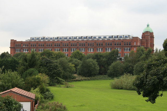
1290:== {{int:filedesc}} == {{Information |description={{en|1=Astley Bridge Mill Another view of this mill also known as Sir John Holden's Mill and the last cotton spinning mill to be built in Bolton. The trees obscure the lower levels and the new penthouses a
210:
402:– You must give appropriate credit, provide a link to the license, and indicate if changes were made. You may do so in any reasonable manner, but not in any way that suggests the licensor endorses you or your use.
224:
274:
1038:
757:
741:
659:
615:
461:
78:
765:
46:
512:
1187:
1142:
1097:
1030:
992:
928:
924:
860:
856:
753:
737:
611:
524:
516:
508:
1034:
761:
749:
745:
699:
655:
520:
504:
457:
1283:
122:
a typical mill chimney, although I've noticed a little brick stack in front of the water tower that might have serviced a central heating boiler.
662:"}},"text\/plain":{"en":{"P275":"Creative Commons Attribution-ShareAlike 2.0 Generic"}}}}": -->
1082:
791:
685:
641:
490:
284:
234:
841:
319:
1320:
This file contains additional information, probably added from the digital camera or scanner used to create or digitize it.
409:
568:
1201:
1156:
1111:
1048:
1002:
969:
942:
901:
874:
819:
775:
625:
591:
576:
561:
1075:
834:
804:
709:
669:
534:
474:
768:"}},"text\/plain":{"en":{"P137":"Geograph Britain and Ireland"}}}}": -->
1272:
1267:
37:
365:
1323:
If the file has been modified from its original state, some details may not fully reflect the modified file.
464:"}},"text\/plain":{"en":{"P180":"Astley Bridge Mill"}}}}": -->
408:– If you remix, transform, or build upon the material, you must distribute your contributions under the
326:
on the
Geograph website for the photographer's contact details. The copyright on this image is owned by
1309:
1104:"}},"text\/plain":{"en":{"P3575":"74,601 byte"}}}}": -->
618:"}},"text\/plain":{"en":{"P6216":"copyrighted"}}}}": -->
1300:
The following pages on the
English Knowledge use this file (pages on other projects are not listed):
935:"}},"text\/plain":{"en":{"P7787":"270 degree"}}}}": -->
867:"}},"text\/plain":{"en":{"P7787":"270 degree"}}}}": -->
1194:"}},"text\/plain":{"en":{"P2049":"640 pixel"}}}}": -->
1149:"}},"text\/plain":{"en":{"P2048":"425 pixel"}}}}": -->
1304:
86:
179:
1041:"}},"text\/plain":{"en":{"P459":"SHA-1"}}}}": -->
826:
811:
583:
362:
163:
8:
306:
290:
240:
331:
73:
152:
142:
1211:
1166:
1121:
1058:
1012:
952:
884:
785:
719:
679:
635:
544:
484:
311:
323:
1240:
Click on a date/time to view the file as it appeared at that time.
276:
226:
261:
53° 36′ 22″ N, 2° 25′ 48″ W
211:
53° 36′ 24″ N, 2° 25′ 36″ W
131:
61:
450:
Add a one-line explanation of what this file represents
1298:
1238:
85:
Commons is a freely licensed media file repository.
686:
Creative
Commons Attribution-ShareAlike 2.0 Generic
660:
Creative
Commons Attribution-ShareAlike 2.0 Generic
111:Astley Bridge Mill - geograph.org.uk - 964370.jpg
47:Astley_Bridge_Mill_-_geograph.org.uk_-_964370.jpg
51:(640 × 425 pixels, file size: 73 KB, MIME type:
419:https://creativecommons.org/licenses/by-sa/2.0
66:
425:Creative Commons Attribution-Share Alike 2.0
343:
127:
108:
750:https:\/\/www.geograph.org.uk\/photo\/964370
521:https:\/\/www.geograph.org.uk\/profile\/4264
148:
137:
14:
1191:
1146:
1101:
932:
864:
385:– to copy, distribute and transmit the work
1064:734c5c8b0ea22440b5ed3236c3afe1e6bfc276d6
812:https://www.geograph.org.uk/photo/964370
584:https://www.geograph.org.uk/profile/4264
283:View this and other nearby images on:
233:View this and other nearby images on:
186:
97:
330:and is licensed for reuse under the
251:
201:
1231:
366:Attribution-Share Alike 2.0 Generic
354:
349:
334:Attribution-ShareAlike 2.0 license.
13:
1318:
455:
449:
340:
317:
115:
98:
44:
1344:
1325:
454:
1299:
875:coordinates of the point of view
857:coordinates of the point of view
440:
396:Under the following conditions:
361:This file is licensed under the
353:
348:
342:
310:
289:
275:
267:
239:
225:
217:
65:
21:
437:
116:
41:No higher resolution available.
1235:
792:file available on the internet
742:file available on the internet
436:
318:This image was taken from the
26:
1:
943:coordinates of depicted place
925:coordinates of depicted place
31:
1295:
842:Geograph Britain and Ireland
766:Geograph Britain and Ireland
562:object of statement has role
509:object of statement has role
470:Items portrayed in this file
302:
266:
216:
7:
1315:
958:53°36'22.21"N, 2°25'48.00"W
890:53°36'23.54"N, 2°25'36.48"W
10:
1349:
1310:Listed buildings in Bolton
410:same or compatible license
105:
100:
1232:
16:
820:geograph.org.uk image ID
754:geograph.org.uk image ID
439:
376:
192:Chris Allen /
173:Chris Allen /
72:This is a file from the
36:
1305:List of mills in Bolton
1289:
1268:16:05, 22 February 2011
164:required by the license
130:
76:. Information from its
324:this photograph's page
295:53.606170; -2.430000
245:53.606540; -2.426800
79:description page there
1076:determination method
1035:determination method
391:– to adapt the work
592:author name string
525:author name string
491:Astley Bridge Mill
462:Astley Bridge Mill
194:Astley Bridge Mill
175:Astley Bridge Mill
1336:
1335:
1293:
1193:
1148:
1103:
934:
866:
725:14 September 2008
670:copyright license
656:copyright license
448:
339:
338:
322:collection. See
300:
299:
250:
249:
199:
198:
167:
132:14 September 2008
94:
93:
74:Wikimedia Commons
1340:
1326:
1280:
1242:
1220:
1175:
1130:
1085:
1080:
980:
979:
974:
912:
911:
906:
844:
839:
829:
824:
814:
809:
805:described at URL
746:described at URL
626:copyright status
612:copyright status
599:
596:
586:
581:
571:
566:
446:
432:
429:
426:
423:
420:
412:as the original.
374:
363:Creative Commons
357:
356:
352:
351:
346:
345:
332:Creative Commons
320:Geograph project
314:
307:
296:
293:
279:
278:
272:
271:
270:
264:
263:
252:
246:
243:
229:
228:
222:
221:
220:
214:
213:
202:
161:
133:
120:
112:
106:
90:
69:
68:
62:
56:
54:
1348:
1347:
1343:
1342:
1341:
1339:
1338:
1337:
1314:
1301:
1294:
1286:
1278:
1234:
1233:
1230:
1229:
1228:
1227:
1226:
1225:
1224:
1223:
1221:
1218:
1208:
1207:
1206:
1204:
1185:
1184:
1183:
1182:
1181:
1180:
1179:
1178:
1176:
1173:
1163:
1162:
1161:
1159:
1140:
1139:
1138:
1137:
1136:
1135:
1134:
1133:
1131:
1128:
1118:
1117:
1116:
1114:
1095:
1094:
1093:
1092:
1091:
1090:
1089:
1088:
1087:
1086:
1081:
1078:
1069:
1068:
1067:
1065:
1055:
1054:
1053:
1051:
1028:
1027:
1026:
1025:
1024:
1023:
1022:
1021:
1019:
1009:
1008:
1007:
1005:
990:
989:
988:
987:
986:
985:
984:
983:
982:
981:
977:
975:
972:
963:
962:
961:
959:
949:
948:
947:
945:
922:
921:
920:
919:
918:
917:
916:
915:
914:
913:
909:
907:
904:
895:
894:
893:
891:
881:
880:
879:
877:
854:
853:
852:
851:
850:
849:
848:
847:
846:
845:
840:
837:
831:
830:
825:
822:
816:
815:
810:
807:
798:
797:
796:
794:
782:
781:
780:
778:
735:
734:
733:
732:
731:
730:
729:
728:
726:
716:
715:
714:
712:
697:
696:
695:
694:
693:
692:
691:
690:
688:
676:
675:
674:
672:
653:
652:
651:
650:
649:
648:
647:
646:
644:
632:
631:
630:
628:
609:
608:
607:
606:
605:
604:
603:
602:
601:
600:
597:
594:
588:
587:
582:
579:
573:
572:
567:
564:
555:
554:
553:
551:
541:
540:
539:
537:
502:
501:
500:
499:
498:
497:
496:
495:
493:
481:
480:
479:
477:
453:
452:
451:
434:
433:
430:
427:
424:
421:
418:
417:
375:
372:
369:
358:
335:
305:
294:
268:
259:
258:
255:Object location
244:
218:
209:
208:
205:Camera location
200:
189:
182:
170:
143:geograph.org.uk
123:
110:
103:
96:
95:
84:
83:
82:is shown below.
58:
52:
50:
43:
42:
12:
11:
5:
1346:
1334:
1333:
1330:
1317:
1313:
1312:
1307:
1297:
1292:
1291:
1288:
1284:
1281:
1275:
1270:
1265:
1261:
1260:
1257:
1254:
1251:
1248:
1245:
1237:
1222:
1216:
1214:
1213:
1212:
1210:
1209:
1205:
1200:
1198:
1197:
1196:
1195:
1189:
1177:
1171:
1169:
1168:
1167:
1165:
1164:
1160:
1155:
1153:
1152:
1151:
1150:
1144:
1132:
1126:
1124:
1123:
1122:
1120:
1119:
1115:
1110:
1108:
1107:
1106:
1105:
1099:
1074:
1073:
1072:
1071:
1070:
1066:
1063:
1061:
1060:
1059:
1057:
1056:
1052:
1047:
1045:
1044:
1043:
1042:
1040:
1036:
1032:
1020:
1017:
1015:
1014:
1013:
1011:
1010:
1006:
1001:
999:
998:
997:
996:
994:
968:
967:
966:
965:
964:
960:
957:
955:
954:
953:
951:
950:
946:
941:
939:
938:
937:
936:
930:
926:
900:
899:
898:
897:
896:
892:
889:
887:
886:
885:
883:
882:
878:
873:
871:
870:
869:
868:
862:
858:
833:
832:
818:
817:
803:
802:
801:
800:
799:
795:
790:
788:
787:
786:
784:
783:
779:
776:source of file
774:
772:
771:
770:
769:
767:
763:
759:
755:
751:
747:
743:
739:
738:source of file
727:
724:
722:
721:
720:
718:
717:
713:
708:
706:
705:
704:
703:
701:
689:
684:
682:
681:
680:
678:
677:
673:
668:
666:
665:
664:
663:
661:
657:
645:
640:
638:
637:
636:
634:
633:
629:
624:
622:
621:
620:
619:
617:
613:
590:
589:
575:
574:
560:
559:
558:
557:
556:
552:
549:
547:
546:
545:
543:
542:
538:
533:
531:
530:
529:
528:
526:
522:
518:
514:
510:
506:
494:
489:
487:
486:
485:
483:
482:
478:
473:
471:
468:
467:
466:
465:
463:
459:
445:
444:
441:
438:
416:
415:
414:
413:
403:
394:
393:
392:
386:
379:You are free:
370:
360:
359:
341:
337:
336:
315:
304:
301:
298:
297:
287:
281:
256:
248:
247:
237:
231:
206:
197:
196:
190:
187:
184:
183:
178:
171:
168:
156:
155:
150:
146:
145:
139:
135:
134:
129:
125:
124:
113:
104:
102:
99:
92:
91:
70:
60:
59:
40:
35:
34:
29:
24:
19:
9:
6:
4:
3:
2:
1345:
1331:
1328:
1327:
1324:
1321:
1311:
1308:
1306:
1303:
1302:
1287:
1282:
1276:
1274:
1271:
1269:
1266:
1263:
1262:
1258:
1255:
1252:
1249:
1246:
1244:
1243:
1241:
1215:
1203:
1199:
1170:
1158:
1154:
1125:
1113:
1109:
1084:
1077:
1062:
1050:
1046:
1016:
1004:
1000:
971:
956:
944:
940:
903:
888:
876:
872:
843:
836:
828:
821:
813:
806:
793:
789:
777:
773:
723:
711:
707:
687:
683:
671:
667:
643:
639:
627:
623:
593:
585:
578:
570:
563:
548:
536:
532:
492:
488:
476:
472:
469:
442:
435:
422:CC BY-SA 2.0
411:
407:
404:
401:
398:
397:
395:
390:
387:
384:
381:
380:
378:
377:
371:Attribution:
367:
364:
347:
333:
329:
325:
321:
316:
313:
309:
308:
292:
288:
286:
285:OpenStreetMap
282:
280:
262:
257:
254:
253:
242:
238:
236:
235:OpenStreetMap
232:
230:
212:
207:
204:
203:
195:
191:
185:
181:
177: /
176:
172:
165:
160:
158:
157:
154:
151:
147:
144:
140:
136:
126:
119:
114:
107:
88:
81:
80:
75:
71:
64:
63:
57:
48:
39:
33:
30:
28:
25:
23:
20:
18:
15:
1322:
1319:
1239:
1236:File history
569:photographer
513:photographer
405:
399:
388:
382:
327:
265:
215:
193:
180:CC BY-SA 2.0
174:
117:
87:You can help
77:
45:
22:File history
1285:GeographBot
642:copyrighted
616:copyrighted
598:Chris Allen
406:share alike
400:attribution
373:Chris Allen
328:Chris Allen
159:Attribution
153:Chris Allen
109:Description
1329:_error
1296:File usage
1277:640 × 425
1253:Dimensions
1018:image/jpeg
1003:media type
993:media type
550:some value
53:image/jpeg
27:File usage
1250:Thumbnail
1247:Date/Time
1112:data size
1098:data size
710:inception
700:inception
303:Licensing
188:InfoField
169:InfoField
118:English:
1316:Metadata
1049:checksum
1031:checksum
835:operator
762:operator
443:Captions
389:to remix
383:to share
368:license.
32:Metadata
1279:(73 KB)
1264:current
1259:Comment
1127:74,601
970:heading
929:heading
902:heading
861:heading
535:creator
505:creator
475:depicts
458:depicts
447:English
101:Summary
49:
1157:height
1143:height
978:degree
933:degree
910:degree
865:degree
827:964370
758:964370
273:
223:
149:Author
138:Source
1219:pixel
1202:width
1192:pixel
1188:width
1174:pixel
1147:pixel
1083:SHA-1
1039:SHA-1
141:From
1256:User
1217:640
1172:425
1129:byte
1102:byte
976:270
908:270
431:true
428:true
128:Date
17:File
577:URL
517:URL
1079::
973::
905::
838::
823::
808::
595::
580::
565::
1332:0
166:)
162:(
89:.
55:)
_heading:270.00&language=en)
_heading:270.00&language=en)
