558:"}},"text\/plain":{"en":{"":"checksum"}}},"{\"value\":\"fe0550908e616fd39ec8c0ef49b12e7817186406\",\"type\":\"string\"}":{"text\/html":{"en":{"P4092":"fe0550908e616fd39ec8c0ef49b12e7817186406"}},"text\/plain":{"en":{"P4092":"fe0550908e616fd39ec8c0ef49b12e7817186406"}}},"{\"value\":{\"entity-type\":\"property\",\"numeric-id\":459,\"id\":\"P459\"},\"type\":\"wikibase-entityid\"}":{"text\/html":{"en":{"":"
38:
482:"}},"text\/plain":{"en":{"":"inception"}}},"{\"value\":{\"time\":\"+2010-11-30T00:00:00Z\",\"timezone\":0,\"before\":0,\"after\":0,\"precision\":11,\"calendarmodel\":\"http:\\\/\\\/www.wikidata.org\\\/entity\\\/Q1985727\"},\"type\":\"time\"}":{"text\/html":{"en":{"P571":"30 November 2010"}},"text\/plain":{"en":{"P571":"30 November 2010"}}}}": -->
242:
554:
253:
94:
562:"}},"text\/plain":{"en":{"":"determination method"}}},"{\"value\":{\"entity-type\":\"item\",\"numeric-id\":13414952,\"id\":\"Q13414952\"},\"type\":\"wikibase-entityid\"}":{"text\/html":{"en":{"P459":"
520:"}},"text\/plain":{"en":{"":"media type"}}},"{\"value\":\"image\\\/jpeg\",\"type\":\"string\"}":{"text\/html":{"en":{"P1163":"image\/jpeg"}},"text\/plain":{"en":{"P1163":"image\/jpeg"}}}}": -->
438:"}},"text\/plain":{"en":{"":"copyright license"}}},"{\"value\":{\"entity-type\":\"item\",\"numeric-id\":14946043,\"id\":\"Q14946043\"},\"type\":\"wikibase-entityid\"}":{"text\/html":{"en":{"P275":"
394:"}},"text\/plain":{"en":{"":"copyright status"}}},"{\"value\":{\"entity-type\":\"item\",\"numeric-id\":50423863,\"id\":\"Q50423863\"},\"type\":\"wikibase-entityid\"}":{"text\/html":{"en":{"P6216":"
625:"}},"text\/plain":{"en":{"":"data size"}}},"{\"value\":{\"amount\":\"+531202\",\"unit\":\"http:\\\/\\\/www.wikidata.org\\\/entity\\\/Q8799\"},\"type\":\"quantity\"}":{"text\/html":{"en":{"P3575":"531,202
670:"}},"text\/plain":{"en":{"":"height"}}},"{\"value\":{\"amount\":\"+1758\",\"unit\":\"http:\\\/\\\/www.wikidata.org\\\/entity\\\/Q355198\"},\"type\":\"quantity\"}":{"text\/html":{"en":{"P2048":"1,758
715:"}},"text\/plain":{"en":{"":"width"}}},"{\"value\":{\"amount\":\"+2000\",\"unit\":\"http:\\\/\\\/www.wikidata.org\\\/entity\\\/Q355198\"},\"type\":\"quantity\"}":{"text\/html":{"en":{"P2049":"2,000
711:
1026:
1056:
300:– You must give appropriate credit, provide a link to the license, and indicate if changes were made. You may do so in any reasonable manner, but not in any way that suggests the licensor endorses you or your use.
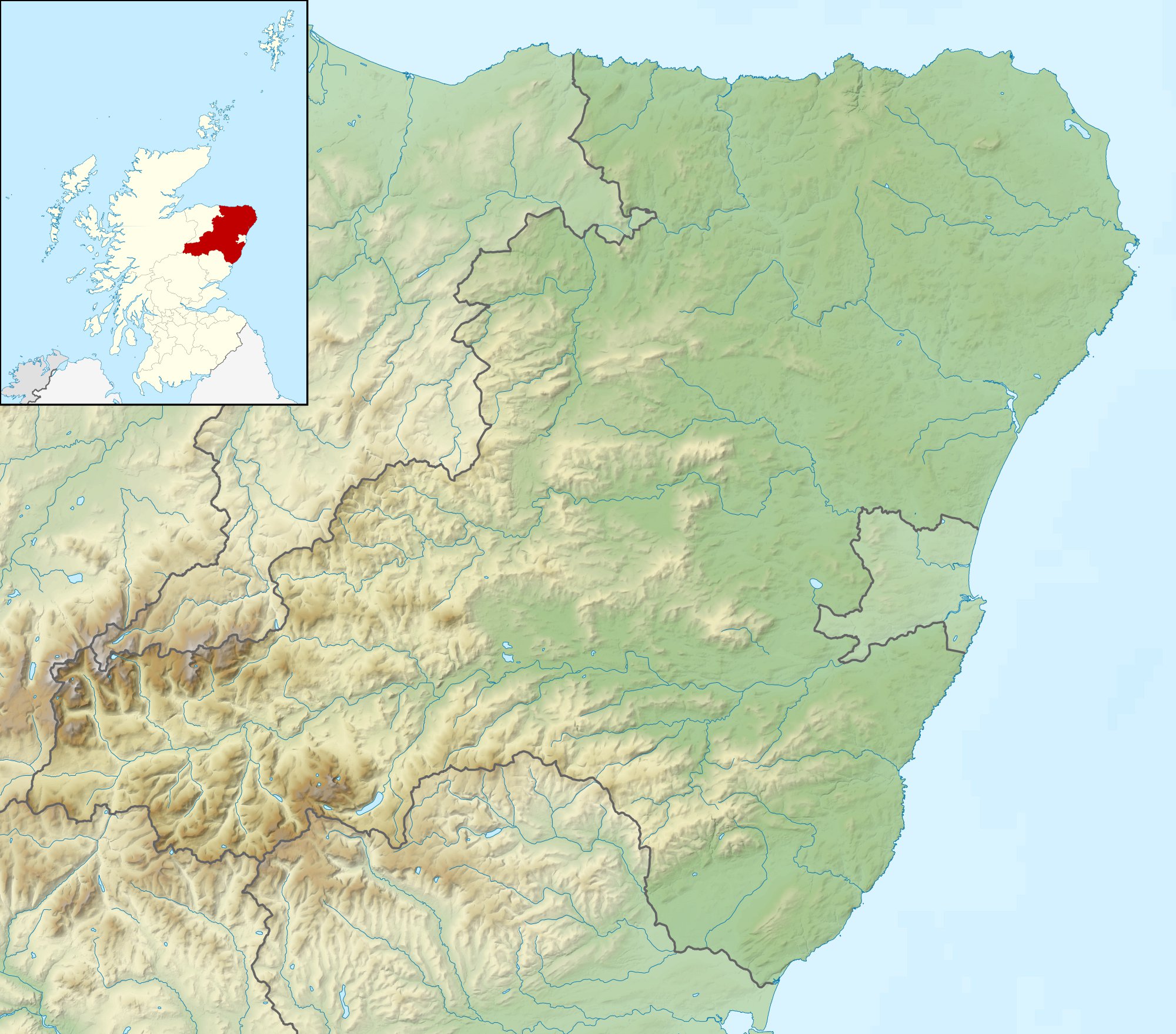
819:, UK. Equirectangular map projection on WGS 84 datum, with N/S stretched 180% Geographic limits: *West: 3.85W *East: 1.70W *North: 57.75N *South: 56.70N |Source=[[w:Ordnance Surve
563:
439:
395:
1295:
712:
667:
622:
555:
517:
391:
559:
479:
435:
60:
56:
52:
48:
42:
105:
73:
998:
993:
442:"}},"text\/plain":{"en":{"P275":"Creative Commons Attribution-ShareAlike 3.0 Unported"}}}}": -->
231:
607:
465:
421:
202:
340:
307:
726:
681:
636:
573:
527:
405:
600:
489:
449:
380:
978:
883:
263:
888:
797:
792:
64:
37:
1016:
306:– If you remix, transform, or build upon the material, you must distribute your contributions under the
968:
873:
629:"}},"text\/plain":{"en":{"P3575":"531,202 byte"}}}}": -->
833:
719:"}},"text\/plain":{"en":{"P2049":"2,000 pixel"}}}}": -->
674:"}},"text\/plain":{"en":{"P2048":"1,758 pixel"}}}}": -->
398:"}},"text\/plain":{"en":{"P6216":"copyrighted"}}}}": -->
829:
The following pages on the
English Knowledge use this file (pages on other projects are not listed):
953:
943:
185:
113:
868:
566:"}},"text\/plain":{"en":{"P459":"SHA-1"}}}}": -->
1046:
1036:
1136:
1071:
260:
988:
8:
963:
1051:
973:
206:
938:
100:
370:
858:
843:
182:
1041:
219:
983:
928:
923:
908:
863:
808:
139:
1081:
958:
948:
933:
898:
816:
1286:
1061:
736:
691:
646:
583:
537:
499:
459:
415:
913:
145:
Equirectangular map projection on WGS 84 datum, with N/S stretched 180%
1131:
918:
903:
893:
848:
1151:
838:
195:
Administrative borders and coastline data from
Boundary-Line product.
765:
Click on a date/time to view the file as it appeared at that time.
271:
Contains
Ordnance Survey data © Crown copyright and database right
1266:
853:
1271:
1256:
1226:
1201:
1196:
1176:
1171:
1161:
1141:
1111:
1281:
1276:
1261:
1241:
1236:
1166:
1116:
1101:
1096:
1091:
878:
1206:
1191:
1246:
1221:
1181:
1251:
1231:
1211:
171:
88:
1186:
1216:
1156:
1126:
1106:
364:
Add a one-line explanation of what this file represents
1146:
1121:
827:
78:(2,000 × 1,758 pixels, file size: 519 KB, MIME type:
1007:
763:
466:
Creative
Commons Attribution-ShareAlike 3.0 Unported
440:
Creative
Commons Attribution-ShareAlike 3.0 Unported
112:
Commons is a freely licensed media file repository.
999:
1027:Ҡалып:ПозКарта Бөйөк Британия Шотландия Абердиншир
198:All other geographic data from Meridian 2 product.
1137:Vorlage:Positionskarte Schottland Aberdeenshire
994:Module:Location map/data/Scotland Aberdeenshire
317:https://creativecommons.org/licenses/by-sa/3.0
93:
1072:Plantilya:Location map Scotland Aberdeenshire
323:Creative Commons Attribution-Share Alike 3.0
241:
226:
167:
130:
336:
215:
192:Relief data from Land-Form Panorama product.
177:
14:
716:
671:
626:
283:– to copy, distribute and transmit the work
1009:The following other wikis use this file:
815:{{Information |Description=Relief map of
1017:قالب:Location map Scotland Aberdeenshire
589:fe0550908e616fd39ec8c0ef49b12e7817186406
133:Aberdeenshire UK relief location map.jpg
203:File: United Kingdom location map.svg
124:
1057:Шаблон:ПК Великобритания Абърдийншър
264:Attribution-Share Alike 3.0 Unported
222:, created using Ordnance Survey data
756:
341:File:Aberdeenshire UK blank map.svg
252:
247:
13:
369:
363:
238:
125:
71:
1307:
368:
979:St Cyrus National Nature Reserve
828:
354:
294:Under the following conditions:
259:This file is licensed under the
251:
246:
240:
201:Inset derived from derived from
92:
31:
21:
1287:Kinnaird Castle (Aberdeenshire)
351:
1004:
884:Forvie National Nature Reserve
760:
350:
26:
1:
1082:Šablona:LocMap Aberdeenshire
889:Fraserburgh Lifeboat Station
824:
376:Items portrayed in this file
7:
1068:Usage on ceb.wikipedia.org
10:
1312:
1088:Usage on de.wikipedia.org
1078:Usage on cs.wikipedia.org
1033:Usage on bg.wikipedia.org
1023:Usage on ba.wikipedia.org
1013:Usage on ar.wikipedia.org
969:Peterhead Lifeboat Station
874:Duff House Royal Golf Club
308:same or compatible license
127:
834:Aberdeen Lifeboat Station
757:
16:
954:PGA Seniors Championship
944:Macduff Lifeboat Station
353:
274:
99:This is a file from the
36:
814:
793:12:14, 30 November 2011
170:
103:. Information from its
869:Dubh Loch (Glen Muick)
106:description page there
41:Size of this preview:
1132:Sgòr an Lochain Uaine
989:Wallace's Castle
601:determination method
560:determination method
65:2,000 × 1,758 pixels
61:1,165 × 1,024 pixels
1267:Inverallochy Castle
964:Peterhead Golf Club
289:– to adapt the work
148:Geographic limits:
47:Other resolutions:
974:Scottish Challenge
1296:more global usage
1272:Inchdrewer Castle
1257:Hallforest Castle
1227:Castle of Rattray
1202:Kindrochit Castle
1197:Glenbuchat Castle
1177:Old Slains Castle
1172:New Slains Castle
1162:Fetteresso Castle
1152:The Devil’s Point
1142:Abergeldie Castle
1112:Craigievar Castle
1005:Global file usage
939:Loch of Strathbeg
822:
718:
673:
628:
450:copyright license
436:copyright license
362:
347:
346:
235:
232:Reusing this file
121:
120:
101:Wikimedia Commons
32:Global file usage
1303:
1282:Kinnairdy Castle
1277:Inverugie Castle
1262:House of Schivas
1242:Fedderate Castle
1237:Esslemont Castle
1167:Balquhain Castle
1117:Findlater Castle
1102:Kildrummy Castle
1097:Dunnottar Castle
1092:Bennachie (Berg)
984:Tap o' Noth
859:Cullykhan Castle
844:Castle of Findon
805:
767:
745:
700:
655:
610:
605:
505:30 November 2010
406:copyright status
392:copyright status
360:
330:
327:
324:
321:
318:
310:as the original.
272:
261:Creative Commons
255:
254:
250:
249:
244:
243:
229:
173:
172:30 November 2010
134:
128:
117:
96:
95:
89:
83:
81:
68:
57:874 × 768 pixels
53:546 × 480 pixels
49:273 × 240 pixels
43:682 × 599 pixels
1311:
1310:
1306:
1305:
1304:
1302:
1301:
1300:
1207:Ben Avon (Berg)
1192:Tolquhon Castle
1003:
830:
823:
811:
803:
759:
758:
755:
754:
753:
752:
751:
750:
749:
748:
746:
743:
733:
732:
731:
729:
710:
709:
708:
707:
706:
705:
704:
703:
701:
698:
688:
687:
686:
684:
665:
664:
663:
662:
661:
660:
659:
658:
656:
653:
643:
642:
641:
639:
620:
619:
618:
617:
616:
615:
614:
613:
612:
611:
606:
603:
594:
593:
592:
590:
580:
579:
578:
576:
553:
552:
551:
550:
549:
548:
547:
546:
544:
534:
533:
532:
530:
515:
514:
513:
512:
511:
510:
509:
508:
506:
496:
495:
494:
492:
477:
476:
475:
474:
473:
472:
471:
470:
468:
456:
455:
454:
452:
433:
432:
431:
430:
429:
428:
427:
426:
424:
412:
411:
410:
408:
389:
388:
387:
386:
385:
383:
367:
366:
365:
348:
332:
331:
328:
325:
322:
319:
316:
315:
273:
270:
267:
256:
183:Ordnance Survey
132:
123:
122:
111:
110:
109:is shown below.
85:
79:
77:
70:
69:
46:
12:
11:
5:
1309:
1298:of this file.
1292:
1291:
1290:
1289:
1284:
1279:
1274:
1269:
1264:
1259:
1254:
1249:
1247:Fordyce Castle
1244:
1239:
1234:
1229:
1224:
1222:Crathes Castle
1219:
1214:
1209:
1204:
1199:
1194:
1189:
1184:
1179:
1174:
1169:
1164:
1159:
1154:
1149:
1144:
1139:
1134:
1129:
1124:
1119:
1114:
1109:
1104:
1099:
1094:
1086:
1085:
1084:
1076:
1075:
1074:
1066:
1065:
1064:
1059:
1054:
1049:
1044:
1039:
1031:
1030:
1029:
1021:
1020:
1019:
1006:
1002:
1001:
996:
991:
986:
981:
976:
971:
966:
961:
956:
951:
946:
941:
936:
931:
929:Loch of Aboyne
926:
924:Loch Vrotachan
921:
916:
911:
909:Loch Etchachan
906:
901:
896:
891:
886:
881:
876:
871:
866:
864:Deeside Gaelic
861:
856:
851:
846:
841:
836:
826:
821:
820:
813:
809:
806:
802:2,000 × 1,758
800:
795:
790:
786:
785:
782:
779:
776:
773:
770:
762:
747:
741:
739:
738:
737:
735:
734:
730:
725:
723:
722:
721:
720:
714:
702:
696:
694:
693:
692:
690:
689:
685:
680:
678:
677:
676:
675:
669:
657:
651:
649:
648:
647:
645:
644:
640:
635:
633:
632:
631:
630:
624:
599:
598:
597:
596:
595:
591:
588:
586:
585:
584:
582:
581:
577:
572:
570:
569:
568:
567:
565:
561:
557:
545:
542:
540:
539:
538:
536:
535:
531:
526:
524:
523:
522:
521:
519:
507:
504:
502:
501:
500:
498:
497:
493:
488:
486:
485:
484:
483:
481:
469:
464:
462:
461:
460:
458:
457:
453:
448:
446:
445:
444:
443:
441:
437:
425:
420:
418:
417:
416:
414:
413:
409:
404:
402:
401:
400:
399:
397:
393:
384:
379:
377:
374:
373:
372:
371:
359:
358:
355:
352:
345:
344:
338:
337:Other versions
334:
333:
314:
313:
312:
311:
301:
292:
291:
290:
284:
277:You are free:
268:
258:
257:
239:
236:
224:
223:
217:
213:
212:
211:
210:
199:
196:
193:
179:
175:
174:
169:
165:
164:
163:
162:
159:
156:
153:
138:Relief map of
135:
126:
119:
118:
97:
87:
86:
40:
35:
34:
29:
24:
19:
9:
6:
4:
3:
2:
1308:
1299:
1297:
1288:
1285:
1283:
1280:
1278:
1275:
1273:
1270:
1268:
1265:
1263:
1260:
1258:
1255:
1253:
1250:
1248:
1245:
1243:
1240:
1238:
1235:
1233:
1230:
1228:
1225:
1223:
1220:
1218:
1215:
1213:
1210:
1208:
1205:
1203:
1200:
1198:
1195:
1193:
1190:
1188:
1185:
1183:
1182:Huntly Castle
1180:
1178:
1175:
1173:
1170:
1168:
1165:
1163:
1160:
1158:
1155:
1153:
1150:
1148:
1145:
1143:
1140:
1138:
1135:
1133:
1130:
1128:
1125:
1123:
1120:
1118:
1115:
1113:
1110:
1108:
1105:
1103:
1100:
1098:
1095:
1093:
1090:
1089:
1087:
1083:
1080:
1079:
1077:
1073:
1070:
1069:
1067:
1063:
1060:
1058:
1055:
1053:
1050:
1048:
1045:
1043:
1040:
1038:
1035:
1034:
1032:
1028:
1025:
1024:
1022:
1018:
1015:
1014:
1012:
1011:
1010:
1000:
997:
995:
992:
990:
987:
985:
982:
980:
977:
975:
972:
970:
967:
965:
962:
960:
959:Peterhead Bay
957:
955:
952:
950:
949:Northern Open
947:
945:
942:
940:
937:
935:
934:Loch of Skene
932:
930:
927:
925:
922:
920:
917:
915:
912:
910:
907:
905:
902:
900:
899:Loch Callater
897:
895:
892:
890:
887:
885:
882:
880:
877:
875:
872:
870:
867:
865:
862:
860:
857:
855:
852:
850:
847:
845:
842:
840:
837:
835:
832:
831:
818:
817:Aberdeenshire
812:
807:
801:
799:
796:
794:
791:
788:
787:
783:
780:
777:
774:
771:
769:
768:
766:
740:
728:
724:
695:
683:
679:
650:
638:
634:
609:
602:
587:
575:
571:
541:
529:
525:
503:
491:
487:
467:
463:
451:
447:
423:
419:
407:
403:
382:
378:
375:
356:
349:
342:
339:
335:
320:CC BY-SA 3.0
309:
305:
302:
299:
296:
295:
293:
288:
285:
282:
279:
278:
276:
275:
269:Attribution:
265:
262:
245:
237:
233:
228:
225:
221:
218:
214:
208:
204:
200:
197:
194:
191:
190:
189:
187:
184:
180:
176:
166:
161:South: 56.70N
160:
158:North: 57.75N
157:
154:
151:
150:
149:
146:
143:
141:
140:Aberdeenshire
136:
129:
115:
108:
107:
102:
98:
91:
90:
84:
75:
74:Original file
66:
62:
58:
54:
50:
44:
39:
33:
30:
28:
25:
23:
20:
18:
15:
1293:
1252:Gight Castle
1232:Ellon Castle
1212:Fyvie Castle
1008:
764:
761:File history
303:
297:
286:
280:
207:NordNordWest
181:
147:
144:
137:
114:You can help
104:
72:
22:File history
1187:Drum Castle
914:Loch Kinord
422:copyrighted
396:copyrighted
343:- Blank map
304:share alike
298:attribution
155:East: 1.70W
152:West: 3.85W
131:Description
1217:Loch Muick
1157:Mount Keen
1127:Cairn Toul
1107:Ben Macdui
919:Loch Muick
904:Loch Davan
894:Glen Tanar
849:Craiginour
825:File usage
778:Dimensions
543:image/jpeg
528:media type
518:media type
227:Permission
80:image/jpeg
27:File usage
1147:Lochnagar
1122:Braeriach
839:Burnfield
810:Nilfanion
775:Thumbnail
772:Date/Time
637:data size
623:data size
490:inception
480:inception
220:Nilfanion
1047:Инвърури
1037:Питърхед
804:(519 KB)
652:531,202
574:checksum
556:checksum
357:Captions
287:to remix
281:to share
266:license.
186:OpenData
1052:Бреймар
789:current
784:Comment
381:depicts
361:English
76:
1042:Хънтли
854:Crovie
742:2,000
697:1,758
682:height
668:height
216:Author
178:Source
142:, UK.
1294:View
1062:Търиф
879:Durno
744:pixel
727:width
717:pixel
713:width
699:pixel
672:pixel
608:SHA-1
564:SHA-1
781:User
654:byte
627:byte
329:true
326:true
168:Date
17:File
205:by
604::
188:.
63:|
59:|
55:|
51:|
45:.
234:)
230:(
209:.
116:.
82:)
67:.