540:
55:
597:
36:
62:
278:. It rises in a swamp about .6 miles (1 km) south of Morris Lake and two miles (3.2 km) east of Echo Lake, near the Lake/Cook County line, at an altitude about 1620 feet (494 m) above sea level. It descends some 1,020 (311 m.) feet in elevation as it flows south to its mouth at
472:
200:
517:
408:
147:
673:
581:
634:
54:
507:
668:
663:
658:
497:
401:
574:
627:
337:
394:
678:
567:
17:
386:
620:
353:
653:
502:
442:
482:
462:
425:
417:
311:
492:
457:
608:
555:
365:
447:
547:
283:
106:
41:
539:
8:
35:
467:
333:
U.S. Geological Survey. National
Hydrography Dataset high-resolution flowline data.
522:
512:
477:
341:
604:
596:
551:
416:
246:
647:
437:
299:
279:
275:
215:
202:
162:
149:
86:
487:
354:
U.S. Geological Survey
Geographic Names Information System: Caribou River
334:
295:
183:
421:
271:
96:
294:
The
Caribou River is a designated trout stream with populations of
603:
This article related to a river or creek in
Minnesota is a
270:
is a 15.0-mile-long (24.1 km) river in northern
61:
645:
628:
575:
402:
635:
621:
582:
568:
409:
395:
16:For other places with the same name, see
674:Lake County, Minnesota geography stubs
646:
390:
591:
534:
13:
327:
282:, also near the eastern border of
14:
690:
546:This article about a location in
23:River in Minnesota, United States
669:Northern Minnesota trout streams
664:Rivers of Lake County, Minnesota
595:
538:
366:"Trout angling: Northeastern MN"
60:
53:
34:
358:
347:
194: • coordinates
141: • coordinates
1:
320:
235:15.0-mile-long (24.1 km)
113:Physical characteristics
659:Tributaries of Lake Superior
607:. You can help Knowledge by
554:. You can help Knowledge by
252:Lake Superior Drainage Basin
7:
312:List of rivers of Minnesota
305:
131: • location
10:
695:
590:
533:
289:
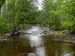
69:Mouth of the Caribou River
40:Looking upstream from the
15:
433:
256:
244:
239:
231:
192:
182:
178:
163:47.5882362°N 91.0243162°W
139:
129:
121:
117:
112:
102:
92:
82:
77:
48:
33:
28:
426:List of Minnesota rivers
216:47.461852°N 91.0287701°W
168:47.5882362; -91.0243162
548:Lake County, Minnesota
344:, accessed May 7, 2012
221:47.461852; -91.0287701
107:Lake County, Minnesota
679:Minnesota river stubs
42:Superior Hiking Trail
654:Rivers of Minnesota
240:Basin features
212: /
159: /
340:2012-03-29 at the
616:
615:
563:
562:
531:
530:
508:Saint Louis River
468:Devil Track River
264:
263:
686:
637:
630:
623:
599:
592:
584:
577:
570:
542:
535:
523:Temperance River
513:Split Rock River
478:Gooseberry River
473:Encampment River
411:
404:
397:
388:
387:
381:
380:
378:
376:
362:
356:
351:
345:
335:The National Map
331:
249:
227:
226:
224:
223:
222:
217:
213:
210:
209:
208:
205:
174:
173:
171:
170:
169:
164:
160:
157:
156:
155:
152:
142:
132:
64:
63:
57:
38:
26:
25:
694:
693:
689:
688:
687:
685:
684:
683:
644:
643:
642:
641:
589:
588:
532:
527:
429:
415:
385:
384:
374:
372:
364:
363:
359:
352:
348:
342:Wayback Machine
332:
328:
323:
317:
308:
292:
245:
220:
218:
214:
211:
206:
203:
201:
199:
198:
195:
167:
165:
161:
158:
153:
150:
148:
146:
145:
140:
130:
73:
72:
71:
70:
67:
66:
65:
44:
24:
21:
12:
11:
5:
692:
682:
681:
676:
671:
666:
661:
656:
640:
639:
632:
625:
617:
614:
613:
600:
587:
586:
579:
572:
564:
561:
560:
543:
529:
528:
526:
525:
520:
515:
510:
505:
500:
495:
490:
485:
480:
475:
470:
465:
460:
455:
450:
445:
440:
434:
431:
430:
414:
413:
406:
399:
391:
383:
382:
357:
346:
325:
324:
322:
319:
315:
314:
307:
304:
291:
288:
262:
261:
258:
254:
253:
250:
242:
241:
237:
236:
233:
229:
228:
196:
193:
190:
189:
186:
180:
179:
176:
175:
143:
137:
136:
133:
127:
126:
123:
119:
118:
115:
114:
110:
109:
104:
100:
99:
94:
90:
89:
84:
80:
79:
75:
74:
68:
59:
58:
52:
51:
50:
49:
46:
45:
39:
31:
30:
22:
9:
6:
4:
3:
2:
691:
680:
677:
675:
672:
670:
667:
665:
662:
660:
657:
655:
652:
651:
649:
638:
633:
631:
626:
624:
619:
618:
612:
610:
606:
601:
598:
594:
593:
585:
580:
578:
573:
571:
566:
565:
559:
557:
553:
549:
544:
541:
537:
536:
524:
521:
519:
516:
514:
511:
509:
506:
504:
501:
499:
496:
494:
493:Manitou River
491:
489:
486:
484:
481:
479:
476:
474:
471:
469:
466:
464:
461:
459:
458:Cascade River
456:
454:
453:Caribou River
451:
449:
446:
444:
441:
439:
438:Baptism River
436:
435:
432:
427:
423:
419:
412:
407:
405:
400:
398:
393:
392:
389:
371:
370:Minnesota DNR
367:
361:
355:
350:
343:
339:
336:
330:
326:
318:
313:
310:
309:
303:
301:
300:rainbow trout
297:
287:
285:
281:
280:Lake Superior
277:
276:United States
273:
269:
268:Caribou River
260:Caribou Falls
259:
255:
251:
248:
243:
238:
234:
230:
225:
197:
191:
188:Lake Superior
187:
185:
181:
177:
172:
144:
138:
134:
128:
124:
120:
116:
111:
108:
105:
101:
98:
95:
91:
88:
87:United States
85:
81:
76:
56:
47:
43:
37:
32:
29:Caribou River
27:
19:
18:Caribou River
609:expanding it
602:
556:expanding it
545:
518:Sucker River
503:Poplar River
498:Pigeon River
488:Lester River
452:
443:Beaver River
373:. Retrieved
369:
360:
349:
329:
316:
293:
267:
265:
247:River system
483:Knife River
463:Cross River
448:Brule River
420:streams of
418:North Shore
284:Lake County
219: /
166: /
648:Categories
321:References
257:Waterfalls
207:91°01′44″W
204:47°27′43″N
154:91°01′28″W
151:47°35′18″N
422:Minnesota
375:March 25,
272:Minnesota
97:Minnesota
338:Archived
306:See also
78:Location
290:Habitat
83:Country
274:, the
232:Length
135:Cramer
125:
122:Source
103:County
550:is a
296:brook
184:Mouth
93:State
605:stub
552:stub
377:2021
298:and
266:The
650::
368:.
302:.
286:.
636:e
629:t
622:v
611:.
583:e
576:t
569:v
558:.
428:)
424:(
410:e
403:t
396:v
379:.
20:.
Text is available under the Creative Commons Attribution-ShareAlike License. Additional terms may apply.

