140:
638:
342:
147:
643:
265:
354:
329:
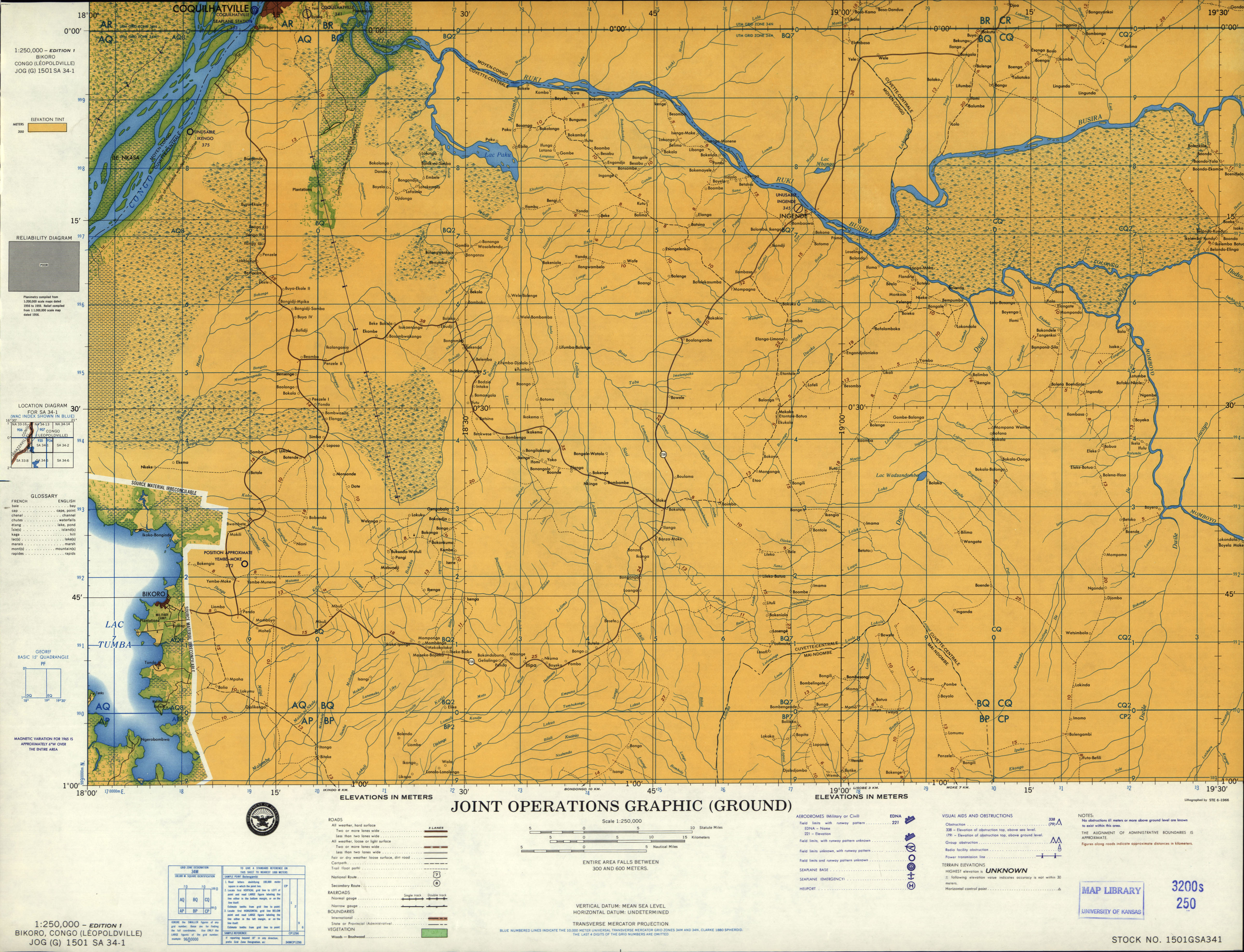
located 7 miles north-east of the town. Additionally, the third letter "B" in the code indicates that the airport is located the former province of
Bandundu. Bikoro is located in the former province of Equateur. It is therefore assumed that FZBC is actually the ICAO code intended for Bokoro airport
458:
451:
444:
97:
467:
368:
139:
704:
363:
680:
321:
Officially, Bokoro
Airport does not have an ICAO-Code. However, the code FZBC is attributed to Bikoro Airport, allegedly serving the town of
699:
236:
72:
495:
346:
654:
325:. Bikoro never had an airport as various old maps and aeronautical charts confirm. It is instead served by the airfield of
282:
673:
399:
308:
290:
500:
471:
244:
275:
666:
90:
387:
436:
490:
286:
426:
637:
80:
431:
8:
240:
505:
485:
612:
602:
597:
248:
41:
30:
617:
576:
561:
556:
546:
358:
650:
581:
566:
551:
541:
536:
526:
521:
693:
607:
571:
531:
326:
112:
99:
247:. The province of Mai-Ndombe is one of three regions the former province of
649:
This article about an airport in the
Democratic Republic of the Congo is a
466:
185:
293:. Statements consisting only of original research should be removed.
642:
322:
172:
369:
List of airports in the
Democratic Republic of the Congo
330:
that has been wrongly assigned due to a spelling error.
364:Transport in the Democratic Republic of the Congo
691:
705:Democratic Republic of the Congo airport stubs
674:
452:
347:Democratic Republic of the Congo portal
681:
667:
459:
445:
309:Learn how and when to remove this message
692:
440:
632:
258:
13:
235:is an airport serving the city of
14:
716:
420:
381:
641:
636:
472:Democratic Republic of the Congo
404:U.S. Defense Intelligence Agency
352:
340:
263:
245:Democratic Republic of the Congo
163:Democratic Republic of the Congo
145:
138:
700:Airports in Mai-Ndombe Province
392:
146:
1:
374:
653:. You can help Knowledge by
7:
333:
289:the claims made and adding
10:
721:
631:
161:Location of the airport in
85:1,080 ft / 329 m
590:
514:
478:
254:
223:
192:
189:
184:
180:
171:
133:
128:
89:
78:
68:
60:
55:
25:
18:
251:has been divided into.
432:OpenStreetMap - Bokoro
388:Google Maps - Bokoro
225:Sources: Google Maps
113:2.88472°S 18.35278°E
400:"JOG 1501 SA 34-01"
359:Aviation portal
241:Mai-Ndombe Province
109: /
427:HERE Maps - Bokoro
274:possibly contains
118:-2.88472; 18.35278
662:
661:
626:
625:
327:Yembe-Moke (FZEM)
319:
318:
311:
276:original research
230:
229:
219:
218:
712:
683:
676:
669:
645:
640:
633:
486:Kinshasa-N'Djili
461:
454:
447:
438:
437:
414:
413:
411:
410:
396:
390:
385:
357:
356:
355:
345:
344:
343:
314:
307:
303:
300:
294:
291:inline citations
267:
266:
259:
182:
181:
175:
149:
148:
142:
124:
123:
121:
120:
119:
114:
110:
107:
106:
105:
102:
48:
37:
16:
15:
720:
719:
715:
714:
713:
711:
710:
709:
690:
689:
688:
687:
629:
627:
622:
613:Kinshasa-N'Dolo
586:
510:
474:
465:
423:
418:
417:
408:
406:
398:
397:
393:
386:
382:
377:
353:
351:
341:
339:
336:
315:
304:
298:
295:
280:
268:
264:
257:
226:
173:
167:
166:
165:
164:
162:
159:
158:
157:
156:
150:
117:
115:
111:
108:
103:
100:
98:
96:
95:
79:Elevation
51:
40:
29:
21:
12:
11:
5:
718:
708:
707:
702:
686:
685:
678:
671:
663:
660:
659:
646:
624:
623:
621:
620:
615:
610:
605:
600:
594:
592:
588:
587:
585:
584:
579:
574:
569:
564:
559:
554:
549:
544:
539:
534:
529:
524:
518:
516:
512:
511:
509:
508:
503:
498:
493:
488:
482:
480:
476:
475:
464:
463:
456:
449:
441:
435:
434:
429:
422:
421:External links
419:
416:
415:
391:
379:
378:
376:
373:
372:
371:
366:
361:
349:
335:
332:
317:
316:
299:September 2024
271:
269:
262:
256:
253:
233:Bokoro Airport
228:
227:
224:
221:
220:
217:
216:
213:
210:
207:
203:
202:
199:
195:
194:
191:
188:
178:
177:
169:
168:
160:
152:
151:
144:
143:
137:
136:
135:
134:
131:
130:
126:
125:
93:
87:
86:
83:
76:
75:
70:
66:
65:
62:
58:
57:
53:
52:
50:
49:
38:
26:
23:
22:
20:Bokoro Airport
19:
9:
6:
4:
3:
2:
717:
706:
703:
701:
698:
697:
695:
684:
679:
677:
672:
670:
665:
664:
658:
656:
652:
647:
644:
639:
635:
634:
630:
619:
616:
614:
611:
609:
606:
604:
601:
599:
596:
595:
593:
589:
583:
580:
578:
575:
573:
570:
568:
565:
563:
560:
558:
555:
553:
550:
548:
545:
543:
540:
538:
535:
533:
530:
528:
525:
523:
520:
519:
517:
513:
507:
504:
502:
499:
497:
494:
492:
489:
487:
484:
483:
481:
479:International
477:
473:
469:
468:Main airports
462:
457:
455:
450:
448:
443:
442:
439:
433:
430:
428:
425:
424:
405:
401:
395:
389:
384:
380:
370:
367:
365:
362:
360:
350:
348:
338:
337:
331:
328:
324:
313:
310:
302:
292:
288:
284:
278:
277:
272:This section
270:
261:
260:
252:
250:
246:
242:
238:
234:
222:
214:
211:
208:
205:
204:
200:
197:
196:
187:
183:
179:
176:
170:
155:
141:
132:
127:
122:
94:
92:
88:
84:
82:
77:
74:
71:
67:
63:
59:
54:
47:
43:
39:
36:
32:
28:
27:
24:
17:
655:expanding it
648:
628:
407:. Retrieved
403:
394:
383:
320:
305:
296:
273:
232:
231:
153:
61:Airport type
45:
34:
591:Unscheduled
116: /
91:Coordinates
694:Categories
506:Mbuji-Mayi
501:Lubumbashi
409:2019-04-06
375:References
283:improve it
104:18°21′10″E
603:Gbadolite
598:Basankusu
496:Kisangani
287:verifying
186:Direction
101:2°53′05″S
618:Tshikapa
577:Mbandaka
515:Domestic
334:See also
249:Bandundu
193:Surface
562:Kolwezi
557:Kananga
547:Kalemie
470:in the
281:Please
190:Length
174:Runways
56:Summary
582:Muanda
567:Lisala
552:Kamina
537:Gemena
527:Bukavu
522:Boende
323:Bikoro
255:Trivia
237:Bokoro
212:3,640
209:1,110
206:11/29
154:Bokoro
73:Bokoro
69:Serves
64:Public
608:Kindu
572:Lodja
542:Isiro
532:Bunia
215:Dirt
651:stub
491:Goma
81:AMSL
46:none
42:ICAO
35:none
31:IATA
285:by
239:in
201:ft
129:Map
696::
402:.
243:,
198:m
44::
33::
682:e
675:t
668:v
657:.
460:e
453:t
446:v
412:.
312:)
306:(
301:)
297:(
279:.
Text is available under the Creative Commons Attribution-ShareAlike License. Additional terms may apply.
