45:
58:
579:
65:
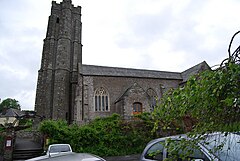
631:"The church as it stands today, is a fine example of the perpendicular style of medieval architecture. It is built on the side of a hill so that its whole length can be seen from below and is dedicated to St Michael and All Angels, which was common practice for churches standing on elevated sites. It was, however, dedicated to St Barnabas and prior to that to St Humbert the Confessor."
323:
For the great majority of towns in
England with names ending in -ham the suffix is very weakly pronounced as /əm/ and the stress is always earlier in the word. In Birmingham, for example, the stress is on the first syllable. Stokenham is a clear exception, with the -ham fully enunciated and stressed.
678:
311:
131:
481:
428:
662:
On the 27th of
September 2021, a fire believed to have originated in the kitchen destroyed much of the pub alongside three neighbouring homes.
836:
217:
759:
1218:
858:
829:
199:
17:
758:
Nicholas Orme, English Church
Dedications: With a Survey of Cornwall and Devon (University of Exeter Press, 1996)
1228:
167:
57:
411:
822:
360:
770:
709:
738:
546:
304:
845:
292:
204:
181:
209:
387:
382:
44:
986:
981:
889:
698:
404:
909:
725:
113:
814:
377:
8:
534:
1223:
1174:
782:
345:
157:
149:
806:
541:("meaning Stoc meadows"). By the 13th century the town was called Stoke in Hamme. An
1179:
1122:
976:
971:
945:
608:
256:
1060:
1025:
640:
596:
1169:
1092:
1035:
996:
966:
904:
879:
542:
1212:
1197:
1132:
1127:
884:
497:
483:
444:
430:
232:
219:
794:
721:
1107:
1087:
866:
647:, abandoned in 1585 but possibly dating back to at least the 12th century.
568:
561:
97:
1147:
1102:
1097:
1065:
1019:
919:
874:
644:
604:
372:
1196:
Bold text denotes a parish council referred to as a town council, i.e.
1112:
1045:
1040:
951:
939:
934:
924:
899:
849:
557:
349:
296:
121:
1184:
1159:
1117:
1030:
1012:
991:
961:
914:
600:
592:
553:
341:
363:
310:
1081:
1075:
1001:
956:
929:
474:
421:
337:
333:
578:
567:
The area was known in the 19th century for the fine crabs, and in
332:
As well as
Stokenham the civil parish includes the settlements of
1164:
1070:
1055:
1050:
894:
625:
173:
1153:
1142:
656:
271:
1006:
807:
Excavations and Survey around the
Village of Stokenham, Devon
572:
300:
139:
78:
571:
local residents were evacuated from the area, on the eve of
844:
265:
280:
655:
The
Tradesman's Arms is an imposing 14th-century, part-
556:
times St. Humbert the
Confessor (d.1188AD) was locally
268:
259:
809:
262:
283:
277:
274:
795:The Church of St Michael and All Angels, Stokenham
1210:
624:The present church dates from 1431; an earlier
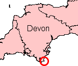
303:, England. The population of the parish at the
545:has the same name. The ward population at the
344:, Kellaton, Kernborough, Dunstone, Beeson and
830:
859:List of civil parishes in Devon#South Hams
837:
823:
599:. The principal road in the parish is the
634:
577:
309:
327:
14:
1211:
533:The village of Stokenham was known in
818:
603:running between the nearest towns of
619:
348:and Bickerton. It forms part of the
24:
614:
25:
1240:
64:
318:
255:
63:
56:
43:
800:
639:Immediately to the east of the
788:
776:
771:Stokenham Devon England Photos
764:
752:
731:
715:
710:Stokenham Devon England Photos
703:
692:
671:
13:
1:
665:
591:To the east of the parish is
1219:Civil parishes in South Hams
650:
586:
582:Start Bay looking north east
7:
388:GPX (secondary coordinates)
299:district, in the county of
32:Human settlement in England
10:
1245:
528:
1193:
865:
856:
846:Non-metropolitan district
643:is the site of Stokenham
408:(Links to map resources)
383:GPX (primary coordinates)
358:Map all coordinates using
190:
180:
166:
148:
130:
112:
96:
88:
51:
42:
37:
27:Village in Devon, England
699:Stokenham Parish Council
679:"Parish population 2011"
366:Download coordinates as:
92:1,895 (2011 census)
783:Stokenham Parish Church
1229:Villages in South Hams
739:"ward population 2011"
583:
350:district of South Hams
315:
233:50.273202°N 3.679744°W
987:Halwell and Moreleigh
982:Frogmore and Sherford
635:Stokenham manor house
581:
378:GPX (all coordinates)
313:
910:Buckland-Tout-Saints
726:Devon County Council
659:pub and restaurant.
628:church predated it.
328:Places in the parish
238:50.273202; -3.679744
182:Sovereign state
797:at Geograph.org.uk.
493: /
440: /
291:) is a village and
229: /
1175:West Buckfastleigh
607:(to the west) and
584:
498:50.2666°N 3.6535°W
316:
1206:
1205:
620:The parish church
526:
525:
445:50.253°N 3.6572°W
314:Stokenham, Devon.
248:
247:
132:Shire county
16:(Redirected from
1236:
972:East Portlemouth
839:
832:
825:
816:
815:
810:
804:
798:
792:
786:
780:
774:
768:
762:
756:
750:
749:
747:
745:
735:
729:
719:
713:
707:
701:
696:
690:
689:
687:
685:
675:
517:
516:
514:
513:
512:
510:
505:
504:
503:50.2666; -3.6535
499:
494:
491:
490:
489:
486:
464:
463:
461:
460:
459:
457:
452:
451:
446:
441:
438:
437:
436:
433:
398:
397:
290:
289:
286:
285:
282:
279:
276:
273:
270:
267:
264:
261:
244:
243:
241:
240:
239:
234:
230:
227:
226:
225:
222:
196:
176:
77:Location within
67:
66:
60:
47:
35:
34:
21:
18:Bickerton, Devon
1244:
1243:
1239:
1238:
1237:
1235:
1234:
1233:
1209:
1208:
1207:
1202:
1189:
1061:Newton and Noss
861:
852:
843:
813:
805:
801:
793:
789:
781:
777:
769:
765:
757:
753:
743:
741:
737:
736:
732:
720:
716:
708:
704:
697:
693:
683:
681:
677:
676:
672:
668:
653:
637:
622:
617:
615:Local landmarks
597:English Channel
589:
531:
508:
506:
502:
500:
496:
495:
492:
487:
484:
482:
480:
479:
455:
453:
450:50.253; -3.6572
449:
447:
443:
442:
439:
434:
431:
429:
427:
426:
407:
396:
395:
394:
393:
392:
330:
321:
258:
254:
237:
235:
231:
228:
223:
220:
218:
216:
215:
214:
194:
172:
162:
144:
126:
108:
84:
83:
82:
81:
75:
74:
73:
72:
68:
33:
28:
23:
22:
15:
12:
11:
5:
1242:
1232:
1231:
1226:
1221:
1204:
1203:
1194:
1191:
1190:
1188:
1187:
1182:
1177:
1172:
1170:West Alvington
1167:
1162:
1157:
1150:
1145:
1140:
1135:
1130:
1125:
1120:
1115:
1110:
1105:
1100:
1095:
1090:
1085:
1078:
1073:
1068:
1063:
1058:
1053:
1048:
1043:
1038:
1036:Littlehempston
1033:
1028:
1023:
1016:
1009:
1004:
999:
994:
989:
984:
979:
974:
969:
967:East Allington
964:
959:
954:
949:
942:
937:
932:
927:
922:
917:
912:
907:
902:
897:
892:
887:
882:
880:Aveton Gifford
877:
871:
869:
867:Civil parishes
863:
862:
857:
854:
853:
842:
841:
834:
827:
819:
812:
811:
799:
787:
775:
763:
751:
730:
714:
702:
691:
669:
667:
664:
652:
649:
636:
633:
621:
618:
616:
613:
611:to the north.
588:
585:
543:electoral ward
530:
527:
524:
523:
521:
518:
477:
471:
470:
468:
465:
424:
418:
417:
414:
409:
402:
391:
390:
385:
380:
375:
369:
356:
355:
354:
329:
326:
320:
317:
246:
245:
213:
212:
207:
202:
197:
195:List of places
191:
188:
187:
186:United Kingdom
184:
178:
177:
170:
164:
163:
161:
160:
154:
152:
146:
145:
143:
142:
136:
134:
128:
127:
125:
124:
118:
116:
110:
109:
107:
106:
102:
100:
94:
93:
90:
86:
85:
76:
70:
69:
62:
61:
55:
54:
53:
52:
49:
48:
40:
39:
31:
26:
9:
6:
4:
3:
2:
1241:
1230:
1227:
1225:
1222:
1220:
1217:
1216:
1214:
1201:
1199:
1192:
1186:
1183:
1181:
1178:
1176:
1173:
1171:
1168:
1166:
1163:
1161:
1158:
1156:
1155:
1151:
1149:
1146:
1144:
1141:
1139:
1136:
1134:
1133:Stoke Gabriel
1131:
1129:
1128:Stoke Fleming
1126:
1124:
1121:
1119:
1116:
1114:
1111:
1109:
1106:
1104:
1101:
1099:
1096:
1094:
1091:
1089:
1086:
1084:
1083:
1079:
1077:
1074:
1072:
1069:
1067:
1064:
1062:
1059:
1057:
1054:
1052:
1049:
1047:
1044:
1042:
1039:
1037:
1034:
1032:
1029:
1027:
1024:
1022:
1021:
1017:
1015:
1014:
1010:
1008:
1005:
1003:
1000:
998:
995:
993:
990:
988:
985:
983:
980:
978:
975:
973:
970:
968:
965:
963:
960:
958:
955:
953:
950:
948:
947:
943:
941:
938:
936:
933:
931:
928:
926:
923:
921:
918:
916:
913:
911:
908:
906:
903:
901:
898:
896:
893:
891:
888:
886:
885:Berry Pomeroy
883:
881:
878:
876:
873:
872:
870:
868:
864:
860:
855:
851:
847:
840:
835:
833:
828:
826:
821:
820:
817:
808:
803:
796:
791:
784:
779:
772:
767:
761:
755:
740:
734:
727:
723:
718:
711:
706:
700:
695:
680:
674:
670:
663:
660:
658:
648:
646:
642:
632:
629:
627:
612:
610:
606:
602:
598:
594:
580:
576:
574:
570:
565:
564:in the town.
563:
559:
555:
550:
548:
544:
540:
536:
522:
519:
515:
478:
476:
473:
472:
469:
466:
462:
425:
423:
420:
419:
415:
413:
410:
406:
403:
400:
399:
389:
386:
384:
381:
379:
376:
374:
371:
370:
368:
367:
362:
361:OpenStreetMap
359:
353:
351:
347:
343:
339:
335:
325:
319:Pronunciation
312:
308:
306:
302:
298:
294:
288:
252:
242:
211:
208:
206:
203:
201:
198:
193:
192:
189:
185:
183:
179:
175:
171:
169:
165:
159:
156:
155:
153:
151:
147:
141:
138:
137:
135:
133:
129:
123:
120:
119:
117:
115:
111:
104:
103:
101:
99:
95:
91:
87:
80:
59:
50:
46:
41:
36:
30:
19:
1195:
1152:
1137:
1108:South Milton
1088:Shaugh Prior
1080:
1018:
1011:
944:
802:
790:
778:
766:
754:
742:. Retrieved
733:
717:
705:
694:
682:. Retrieved
673:
661:
654:
638:
630:
623:
590:
569:World War II
566:
562:patron saint
551:
538:
532:
365:
364:
357:
331:
322:
293:civil parish
250:
249:
98:Civil parish
29:
1148:Thurlestone
1103:South Huish
1098:South Brent
1066:North Huish
1020:Kingsbridge
920:Chivelstone
875:Ashprington
744:20 February
645:manor house
605:Kingsbridge
549:was 1,895.
547:2011 census
537:as Stoc or
535:Saxon Times
501: /
448: /
412:OS Grid Ref
405:Coordinates
346:Chillington
307:was 1,895.
305:2011 census
236: /
1213:Categories
1113:South Pool
1046:Malborough
1041:Loddiswell
952:Dean Prior
940:Dartington
935:Cornworthy
925:Churchstow
900:Blackawton
850:South Hams
666:References
539:Stoc Hamme
507: (
485:50°16′00″N
454: (
432:50°15′11″N
297:South Hams
221:50°16′24″N
158:South West
122:South Hams
89:Population
1224:Stokenham
1185:Yealmpton
1180:Woodleigh
1160:Ugborough
1138:Stokenham
1123:Staverton
1118:Sparkwell
1031:Kingswear
1013:Ivybridge
992:Harberton
977:Ermington
962:Dittisham
946:Dartmouth
915:Charleton
890:Bickleigh
722:Stokenham
651:Local pub
609:Dartmouth
593:Start Bay
587:Geography
558:venerated
554:Mediaeval
520:SX822420
488:3°39′13″W
467:SX818406
435:3°39′26″W
342:Hallsands
251:Stokenham
224:3°40′47″W
105:Stokenham
71:Stokenham
38:Stokenham
1082:Salcombe
1076:Ringmore
1026:Kingston
1002:Holbeton
957:Diptford
930:Cornwood
785:website.
728:website.
657:thatched
509:Torcross
475:Torcross
456:Beesands
422:Beesands
338:Beesands
334:Torcross
114:District
1165:Wembury
1093:Slapton
1071:Rattery
1056:Modbury
1051:Marldon
997:Harford
905:Brixton
895:Bigbury
760:page 24
684:6 April
595:in the
529:History
295:in the
205:England
174:England
168:Country
1154:Totnes
1143:Strete
641:church
626:Norman
416:Notes
401:Point
150:Region
1198:towns
1007:Holne
573:D-day
301:Devon
210:Devon
140:Devon
79:Devon
746:2015
686:2015
601:A379
848:of
724:at
560:as
552:In
373:KML
1215::
575:.
352:.
340:,
336:,
272:ən
266:oʊ
200:UK
1200:.
838:e
831:t
824:v
773:.
748:.
712:.
688:.
511:)
458:)
287:/
284:m
281:æ
278:h
275:ˈ
269:k
263:t
260:s
257:/
253:(
20:)
Text is available under the Creative Commons Attribution-ShareAlike License. Additional terms may apply.


