31:
255:…I took two men in a Small Canoe and ascended the Columbia river to an Island near the Stard. Shore on which two large Mat Lodges of Indians were drying Salmon,…there is no timber of any Sort except Small willow bushes in Sight in any direction - from this Island the natives showed me the entrance of a large Westerly fork which they Call Tâpetêtt at about 8 miles distant, the evening being late I deturmined to return to the forks, at which place I reached at Dark…
332:
314:
220:
228:
38:
262:
In 1872 the island was being used for wheat farming, and in 1912 it was used for raising cows. The causeway that connects the island to the shore was completed sometime around 1940. From 1941 to 1952 the
Batemans used the island to raise turkeys and for farming.
285:
Presently, the island is open to the public for numerous activities. Evidence of the recent fires is apparent, though the vegetation is rebounding quickly. The island is home to many different species of wildlife, including deer, birds,
216:, in the United States. It is approximately 1 mile (1.6 km) long and 0.5 miles (0.80 km) wide (160 acres (65 ha)) and is part of the city of Richland. Bateman Island was formerly known as Riverview Island.
477:
726:
270:
periodically, most recently in August 2001 and July 2017. In both cases, the fires were caused by human activity and led to extended closures of the island to visitation.
716:
484:
452:
706:
701:
731:
290:
in the wet season, and numerous small animals. Common recreational activities include fishing, bird watching, and hiking. The island also has multiple
358:
711:
721:
696:
83:
582:
470:
30:
457:
277:
and with help from many volunteers, about 27 tons worth of beer cans and other debris left there over the last 60 years was removed.
528:
551:
587:
380:
396:
670:
462:
259:
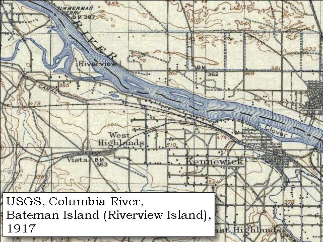
Lewis and Clark never made it past
Bateman Island; it was the furthest upstream they traveled on the Columbia.
602:
546:
523:
240:
506:
166:
675:
650:
645:
336:
417:
635:
494:
515:
213:
619:
538:
209:
176:
71:
8:
274:
566:
498:
441:
205:
156:
611:
376:
640:
561:
492:
318:
201:
67:
690:
303:
244:
98:
85:
429:
248:
453:
More on the background of
Bateman island and relation to Lewis & Clark
458:
A short description of the wildfire that plagued
Bateman island in 2001
291:
267:
219:
313:
251:, but due to the time the farthest they got was Bateman Island.
227:
373:
Original
Journals of the Lewis and Clark Expedition, Volume 3
359:
USGS, Columbia River, Bateman Island (Riverview Island) 1917
287:
247:
and two other men made their way towards the mouth of the
243:
mentioned
Bateman Island in their journals in 1805.
727:
Islands of the
Columbia River in Washington (state)
717:Tourist attractions in Franklin County, Washington
707:Tourist attractions in Benton County, Washington
688:
702:Protected areas of Washington (state) by county
478:
583:Manhattan Project National Historical Park
485:
471:
375:. Digital Scanning Inc. pp. 123–124.
732:Uninhabited islands of Washington (state)
712:Geography of Franklin County, Washington
370:
226:
218:
364:
722:Landforms of Benton County, Washington
697:Geography of Benton County, Washington
689:
37:
466:
273:In 2002 thanks to support by Bechtel
529:Southridge Sports and Events Complex
266:The island has suffered damage from
552:Badger Mountain Centennial Preserve
118:0.25 sq mi (0.65 km)
13:
14:
743:
588:Umatilla National Wildlife Refuge
493:Protected areas and parks in the
442:Three Rivers Community Roundtable
330:
312:
36:
29:
671:Hanford Reach National Monument
223:Fishing spots on Bateman Island
435:
423:
411:
389:
371:Thwaites, Reuben Gold (2001).
352:
280:
1:
418:Bateman Island and Tri-Cities
345:
337:Pacific Northwest portal
200:is an island located on the
7:
430:Bateman Island hiking trail
297:
134:0.57 mi (0.92 km)
126:0.83 mi (1.34 km)
50:Bateman Island (Washington)
10:
748:
235:
663:
628:
610:
601:
575:
537:
514:
505:
397:"Yakima Delta Assessment"
187:
182:
172:
162:
152:
143:
138:
130:
122:
114:
77:
63:
58:
24:
676:Sacagawea Heritage Trail
651:Palouse Falls State Park
646:Juniper Dunes Wilderness
399:. Mid Columbia Fisheries
204:immediately east of the
231:Trail on Bateman Island
641:Lyons Ferry State Park
636:Columbia Plateau Trail
257:
232:
224:
208:between the cities of
253:
230:
222:
214:Kennewick, Washington
620:Sacajawea State Park
72:Richland, Washington
444:Accessed 2016-02-23
432:Accessed 2016-02-23
420:Accessed 2016-02-23
361:Accessed 2016-02-23
95: /
21:
567:Yakima River Delta
547:Columbia Park West
524:Columbia Park East
319:Islands portal
233:
225:
206:Yakima River Delta
99:46.245°N 119.226°W
19:
684:
683:
659:
658:
597:
596:
339:
321:
195:
194:
739:
608:
607:
562:Howard Amon Park
512:
511:
487:
480:
473:
464:
463:
445:
439:
433:
427:
421:
415:
409:
408:
406:
404:
393:
387:
386:
368:
362:
356:
335:
334:
333:
328:
317:
316:
310:
110:
109:
107:
106:
105:
104:46.245; -119.226
100:
96:
93:
92:
91:
88:
40:
39:
33:
22:
18:
747:
746:
742:
741:
740:
738:
737:
736:
687:
686:
685:
680:
655:
624:
603:Franklin County
593:
571:
533:
501:
495:Tri-Cities area
491:
449:
448:
440:
436:
428:
424:
416:
412:
402:
400:
395:
394:
390:
383:
369:
365:
357:
353:
348:
331:
329:
311:
300:
283:
241:Lewis and Clark
238:
148:
103:
101:
97:
94:
89:
86:
84:
82:
81:
54:
53:
52:
51:
48:
47:
46:
45:
41:
17:
16:American Island
12:
11:
5:
745:
735:
734:
729:
724:
719:
714:
709:
704:
699:
682:
681:
679:
678:
673:
667:
665:
661:
660:
657:
656:
654:
653:
648:
643:
638:
632:
630:
626:
625:
623:
622:
616:
614:
605:
599:
598:
595:
594:
592:
591:
585:
579:
577:
573:
572:
570:
569:
564:
559:
557:Bateman Island
554:
549:
543:
541:
535:
534:
532:
531:
526:
520:
518:
509:
503:
502:
490:
489:
482:
475:
467:
461:
460:
455:
447:
446:
434:
422:
410:
388:
381:
363:
350:
349:
347:
344:
343:
342:
324:
306:
299:
296:
282:
279:
237:
234:
202:Columbia River
198:Bateman Island
193:
192:
189:
185:
184:
180:
179:
174:
170:
169:
164:
160:
159:
154:
150:
149:
144:
141:
140:
139:Administration
136:
135:
132:
128:
127:
124:
120:
119:
116:
112:
111:
79:
75:
74:
68:Columbia River
65:
61:
60:
56:
55:
49:
44:Bateman Island
43:
42:
35:
34:
28:
27:
26:
25:
20:Bateman Island
15:
9:
6:
4:
3:
2:
744:
733:
730:
728:
725:
723:
720:
718:
715:
713:
710:
708:
705:
703:
700:
698:
695:
694:
692:
677:
674:
672:
669:
668:
666:
662:
652:
649:
647:
644:
642:
639:
637:
634:
633:
631:
627:
621:
618:
617:
615:
613:
609:
606:
604:
600:
589:
586:
584:
581:
580:
578:
574:
568:
565:
563:
560:
558:
555:
553:
550:
548:
545:
544:
542:
540:
536:
530:
527:
525:
522:
521:
519:
517:
513:
510:
508:
507:Benton County
504:
500:
496:
488:
483:
481:
476:
474:
469:
468:
465:
459:
456:
454:
451:
450:
443:
438:
431:
426:
419:
414:
398:
392:
384:
382:9781582186542
378:
374:
367:
360:
355:
351:
341:
340:
338:
325:
323:
322:
320:
315:
307:
305:
304:Clover Island
302:
301:
295:
293:
289:
278:
276:
271:
269:
264:
260:
256:
252:
250:
246:
245:William Clark
242:
229:
221:
217:
215:
211:
207:
203:
199:
190:
186:
181:
178:
175:
171:
168:
167:Benton County
165:
161:
158:
155:
151:
147:
146:United States
142:
137:
133:
129:
125:
121:
117:
113:
108:
80:
76:
73:
69:
66:
62:
57:
32:
23:
556:
437:
425:
413:
401:. Retrieved
391:
372:
366:
354:
327:
326:
309:
308:
284:
272:
265:
261:
258:
254:
249:Yakima River
239:
197:
196:
183:Demographics
145:
281:Attractions
102: /
90:119°13′34″W
78:Coordinates
691:Categories
499:Washington
346:References
188:Population
157:Washington
87:46°14′42″N
590:(Partial)
516:Kennewick
292:geocaches
59:Geography
539:Richland
298:See also
268:wildfire
210:Richland
177:Richland
64:Location
294:on it.
275:Hanford
236:History
379:
163:County
123:Length
664:Other
629:Other
612:Pasco
576:Other
403:6 May
153:State
131:Width
405:2018
377:ISBN
288:carp
212:and
173:City
115:Area
693::
497:,
70:,
486:e
479:t
472:v
407:.
385:.
191:0
Text is available under the Creative Commons Attribution-ShareAlike License. Additional terms may apply.


