45:
61:
779:
68:
308:
Karatal and other river valleys began. Also during the
Pleistocene, glaciations and intensive ice melting resulted in the Balkash deepening and increasing in size, reconnecting with the Alakol as a single lake. By the Holocene, however, the area became shallow and the single body of water split up into modern lakes Balkhash, Alakol and Sasykkol.
316:
The
Balkhash-Alakol Basin stretches roughly from east to west for about 100 km (62 mi) and has an average width between 100 km (62 mi) and 300 km (190 mi), with a maximum width of 350 km (220 mi). The basin has two parts, the Balkhash depression in the west and
307:
split the fresh Zaysan and the brackish Alakol into independent lakes, causing them to significantly decrease in size. Balkhash, however, became larger and divided into a fresh western and a salty eastern part that characterize its present configuration. At the same time, the formation of the Ili,
321:
in the east. The elevation ranges from 342 m (1,122 ft) —at the surface of lake
Balkhash— to a maximum of 600 m (2,000 ft) towards the eastern end. To the northwest and north the depression is limited by the
501:
295:
the
Balkhash depression filled with sediments and lake Balkhash became shallow and desalinated. At the same time, Alakol and Zaisan were merged into a single lake. In the
789:
513:
Sala, Renato; Deom, Jean-Marc; Aladin, Nikolai V.; Plotnikov, Igor S.; Nurtazin, Sabyr (2020). "Geological
History and Present Conditions of Lake Balkhash".
261:
44:
257:
273:
92:
401:, which are part of the basin even though not reaching the lake. Besides the Balkhash and Alakol, other lakes of the basin are the
386:
60:
276:
took shape and filled with saltwater, covering roughly the area of the present-day basin with an eastern extension that included
783:
532:
764:/ Ch. ed. B.O. Jakyp. — Almaty: « Kazakh encyclopedia» ZhSS, 2011. ISBN 9965-893-64-0(T.Z.),ISBN 9965-893-19-5
804:
638:
477:
441:
desert and semi-desert areas. The main species that grow are salt-tolerant shrubs and grasses, such as
555:
331:
418:
149:
472:
699:
650:
362:
327:
8:
281:
703:
654:
288:
this sea dried up, leaving residual lakes, including
Balkhash, Alakol, Zaisan and Gobi.
715:
303:, tectonic processes intensified, causing the entire depression to deepen. The rising
252:
The basin was formed as a result of a trough that filled with river sediments. In the
528:
514:
502:
Changes in glaciation of the
Balkhash–Alakol basin, central Asia, over recent decades
460:
456:
343:
662:
390:
707:
658:
520:
304:
222:
137:
35:
426:
398:
361:
river, flowing into Lake
Balkhash from the south. Other important rivers are the
241:
208:
524:
732:
560:
382:
323:
318:
141:
616:
592:
798:
438:
402:
370:
366:
347:
253:
233:
145:
107:
94:
550:
577:
410:
406:
378:
339:
437:
The vegetation of the
Balkhash-Alakol Depression is characteristic of the
747:
675:
482:
358:
300:
277:
237:
719:
687:
447:
226:
127:
240:, the largest waterbodies in the trough. The main city in the area is
637:
Wan, Bo; Li, Shihu; Xiao, Wenjiao; Windley, Brian F. (October 2018).
351:
285:
711:
49:
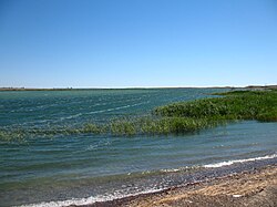
View of the shores of Lake
Balkhash, the main waterbody of the basin
414:
296:
735:
On the origin of Lake Balkhash and the Balkhash-Alakol depression
452:
374:
292:
265:
778:
442:
422:
394:
269:
563:. - 3rd ed. - M. Soviet Encyclopedia, 1969-1978. (in Russian)
335:
193:
342 m (1,122 ft) to 600 m (2,000 ft)
512:
676:Палеоазиатский океан - Большая российская энциклопедия
463:. Parts of the basin are used seasonally for pasture.
185:
100 km (62 mi) to 300 km (190 mi)
417:, among a few smaller ones. The basin includes the
796:
639:"Where and when did the Paleo-Asian ocean form?"
636:
216:
67:
790:Ecosystem management in Balkhash Lake basin
688:"M. Obrucheff's Explorations in Mongolia"
357:The main watercourse of the basin is the
164:ca 22,000 km (8,500 sq mi)
280:and reached further eastwards into the
256:the whole area was part of the ancient
797:
611:
609:
587:
585:
264:. This ancient sea disappeared in the
617:"L-44 Topographic Chart (in Russian)"
593:"L-43 Topographic Chart (in Russian)"
546:
544:
516:Large Asian Lakes in a Changing World
573:
571:
569:
519:. Springer Water. pp. 143–175.
606:
582:
342:mountains, and to the south by the
13:
755:
541:
14:
816:
771:
566:
777:
762:Kazakhstan National Encyclopedia
66:
59:
43:
741:
726:
663:10.1016/j.precamres.2018.09.003
232:The basin is named after lakes
680:
669:
630:
506:
495:
1:
488:
551:Балхаш-Алакольская котловина
311:
218:Балхаш-Алакольская котловина
28:Балхаш-Алакольская котловина
7:
525:10.1007/978-3-030-42254-7_5
466:
10:
821:
750:Балхаш-Алакольская впадина
478:Outline of plate tectonics
326:, to the northeast by the
247:
205:Balkhash-Alakol Depression
733:Stasiv Igor Vasilievich,
556:Great Soviet Encyclopedia
217:
212:
189:
181:
177:700 km (430 mi)
173:
168:
160:
155:
133:
123:
88:
54:
42:
33:
21:
692:The Geographical Journal
432:
559:in 30 vols. — Ch. ed.
150:East Kazakhstan Region
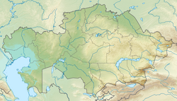
80:Location in Kazakhstan
805:Balkhash-Alakol Basin
784:Balkhash Alakol Basin
473:Geology of Kazakhstan
330:, to the west by the
201:Balkhash-Alakol Basin
74:Balkhash-Alakol Basin
23:Balkhash-Alakol Basin
786:at Wikimedia Commons
698:(3): 260–265. 1895.
643:Precambrian Research
346:in the east and the
328:Tarbagatai Mountains
748:Александр Бабкин —
704:1895GeogJ...5..260.
655:2018PreR..317..241W
260:, a vestige of the
213:Балқаш-Алакөл ойысы
174: • Length
104: /
26:Балқаш-Алакөл ойысы
16:Plain in Kazakhstan
182: • Width
161: • Total
782:Media related to
534:978-3-030-42253-0
393:, as well as the
354:mountain system.
344:Dzungarian Alatau
262:Palaeoasian Ocean
197:
196:
108:46.000°N 77.500°E
812:
781:
765:
759:
753:
745:
739:
730:
724:
723:
684:
678:
673:
667:
666:
634:
628:
627:
625:
623:
613:
604:
603:
601:
599:
589:
580:
575:
564:
548:
539:
538:
510:
504:
499:
305:Tarbagatai Range
225:in southeastern
223:structural basin
220:
219:
214:
138:Karaganda Region
119:
118:
116:
115:
114:
109:
105:
102:
101:
100:
97:
70:
69:
63:
47:
19:
18:
820:
819:
815:
814:
813:
811:
810:
809:
795:
794:
774:
769:
768:
760:
756:
746:
742:
731:
727:
712:10.2307/1773935
686:
685:
681:
674:
670:
635:
631:
621:
619:
615:
614:
607:
597:
595:
591:
590:
583:
576:
567:
549:
542:
535:
511:
507:
500:
496:
491:
469:
435:
429:sandy deserts.
419:Saryesik-Atyrau
314:
258:Dzhungarian Sea
250:
215:; Russian:
112:
110:
106:
103:
98:
95:
93:
91:
90:
84:
83:
82:
81:
78:
77:
76:
75:
71:
50:
38:
29:
27:
24:
17:
12:
11:
5:
818:
808:
807:
793:
792:
787:
773:
772:External links
770:
767:
766:
754:
740:
725:
679:
668:
629:
605:
581:
565:
561:A.M. Prokhorov
540:
533:
505:
493:
492:
490:
487:
486:
485:
480:
475:
468:
465:
434:
431:
350:, part of the
324:Kazakh Uplands
319:artesian basin
313:
310:
249:
246:
195:
194:
191:
187:
186:
183:
179:
178:
175:
171:
170:
166:
165:
162:
158:
157:
153:
152:
142:Zhambyl Region
135:
131:
130:
125:
121:
120:
113:46.000; 77.500
86:
85:
79:
73:
72:
65:
64:
58:
57:
56:
55:
52:
51:
48:
40:
39:
34:
31:
30:
25:
22:
15:
9:
6:
4:
3:
2:
817:
806:
803:
802:
800:
791:
788:
785:
780:
776:
775:
763:
758:
752:
751:
744:
737:
736:
729:
721:
717:
713:
709:
705:
701:
697:
693:
689:
683:
677:
672:
664:
660:
656:
652:
648:
644:
640:
633:
618:
612:
610:
594:
588:
586:
579:
574:
572:
570:
562:
558:
557:
552:
547:
545:
536:
530:
526:
522:
518:
517:
509:
503:
498:
494:
484:
481:
479:
476:
474:
471:
470:
464:
462:
458:
454:
450:
449:
444:
440:
439:Kazakh Steppe
430:
428:
424:
420:
416:
412:
408:
404:
400:
396:
392:
388:
384:
380:
376:
372:
368:
364:
360:
355:
353:
349:
348:Chu-Ili Range
345:
341:
337:
333:
329:
325:
320:
309:
306:
302:
298:
294:
289:
287:
283:
279:
275:
271:
267:
263:
259:
255:
254:Carboniferous
245:
243:
239:
235:
230:
228:
224:
221:), is a flat
210:
206:
202:
192:
188:
184:
180:
176:
172:
167:
163:
159:
154:
151:
147:
146:Almaty Region
143:
139:
136:
132:
129:
126:
122:
117:
89:Coordinates:
87:
62:
53:
46:
41:
37:
32:
20:
761:
757:
749:
743:
738:(in Russian)
734:
728:
695:
691:
682:
671:
646:
642:
632:
622:27 September
620:. Retrieved
598:27 September
596:. Retrieved
578:Google Earth
554:
515:
508:
497:
446:
436:
411:Kashkanteniz
407:Zhalanashkol
356:
340:Maizharylgan
315:
290:
274:Khankhai Sea
251:
231:
204:
200:
198:
649:: 241–252.
483:Panthalassa
317:the Alakol
301:Pleistocene
278:Lake Zaysan
111: /
489:References
448:Calligonum
282:Gobi Lakes
227:Kazakhstan
169:Dimensions
128:Kazakhstan
461:winterfat
352:Tien Shan
312:Geography
286:Oligocene
284:. In the
268:. By the
190:Elevation
799:Category
467:See also
457:wormwood
453:saltwort
427:Muyunkum
415:Itishpes
403:Sasykkol
397:and the
297:Pliocene
242:Balkhash
234:Balkhash
124:Location
720:1773935
700:Bibcode
651:Bibcode
399:Bakanas
375:Karatal
332:Zheltau
293:Miocene
291:In the
266:Permian
248:Geology
134:Part of
99:77°30′E
718:
531:
443:saxaul
423:Taukum
395:Tokrau
391:Ayagöz
387:Tentek
383:Urzhar
270:Eocene
238:Alakol
209:Kazakh
96:46°0′N
716:JSTOR
433:Flora
371:Lepsy
367:Koksu
336:Aitau
36:Basin
624:2022
600:2022
529:ISBN
459:and
425:and
413:and
389:and
379:Emil
363:Aksu
338:and
299:and
272:the
236:and
199:The
156:Area
148:and
708:doi
659:doi
647:317
521:doi
359:Ili
203:or
801::
714:.
706:.
694:.
690:.
657:.
645:.
641:.
608:^
584:^
568:^
553:;
543:^
527:.
455:,
451:,
445:,
421:,
409:,
405:,
385:,
381:,
377:,
373:,
369:,
365:,
334:,
244:.
229:.
211::
144:,
140:,
722:.
710::
702::
696:5
665:.
661::
653::
626:.
602:.
537:.
523::
207:(
Text is available under the Creative Commons Attribution-ShareAlike License. Additional terms may apply.

