27:
50:
198:
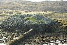
is little space between the edge of the rock and the base of the building. It is a dry-built circular construction with an interior diameter of 24 feet (7.3 m), the wall being 10 feet 6 inches (3.20 m) thick near the base. The entrance passage is from the south, only 2 feet (0.61 m) wide at the interior end, and remains to a height of 3 feet 6 inches (1.07 m) on the left side. Only one or two of the lowest courses of the outside wall of the building remain visible in places, and the rest is concealed by ruins. The interior has probably been cleared of debris, and there the wall exists to a height of 7 feet 4 inches (2.24 m).
43:
236:
201:
A 1911 survey of the broch reported that "there are no signs of chambers in the walls, nor of galleries, the building is poor, the stones are not carefully selected and laid, and the numerous interstices are packed with small angular fragments". A later, 1980, appraisal notes that "reservations on it
197:
An Dun stands on an isolated rock at the south end of Loch
Ardbhair, a sea inlet, and on its eastern shore, about 100 foot (30 m) from the mainland, to which it is connected by a rough causeway of boulders, now part displaced. The broch is only approachable at low tide, and at high water there
42:
319:
191:
202:
being a broch are caused by its small size, and absence of evidence of intra-mural chambers. On balance it is more likely to be a broch."
71:
314:
225:
227:
163:
26:
226:
Royal
Commission on the Ancient and Historical Monuments and Constructions of Scotland (1911).
168:
278:
8:
187:
253:
206:
118:
229:
Second Report and
Inventory of Monuments and Constructions in the County of Sutherland
309:
303:
240:
86:
73:
180:
239:
This article incorporates text from this source, which is in the
183:
106:
301:
320:Archaeological sites in Highland (council area)
279:"An Dun,broch 800m SSW of Ardvar,Loch Ardbhair"
129:An Dun, broch 800m SSW of Ardvar, Loch Ardbhair
25:
219:
137:Prehistoric domestic and defensive: broch
302:
246:
271:
13:
14:
331:
234:
48:
41:
315:Scheduled monuments in Scotland
283:Historic Envieronment Scotland
49:
1:
212:
164:Historic Environment Scotland
7:
10:
336:
194:, Highland, Scotland, UK.
162:
157:
153:
149:
141:
133:
125:
116:
112:
102:
65:
36:
24:
16:Iron Age fort in Scotland
205:An Dun was designated a
254:"An Dun, Loch Ardbhair"
87:58.249614°N 5.122025°W
190:at the south-east of
57:Shown within Highland
31:An Dun, Loch Ardbhair
209:on 14 October 1938.
92:58.249614; -5.122025
83: /
21:
232:. HMSO. p. 2.
207:Scheduled Monument
119:Scheduled monument
19:
174:
173:
327:
294:
293:
291:
289:
275:
269:
268:
266:
264:
250:
244:
238:
237:
233:
223:
98:
97:
95:
94:
93:
88:
84:
81:
80:
79:
76:
52:
51:
45:
29:
22:
18:
335:
334:
330:
329:
328:
326:
325:
324:
300:
299:
298:
297:
287:
285:
277:
276:
272:
262:
260:
252:
251:
247:
235:
224:
220:
215:
145:14 October 1938
121:
91:
89:
85:
82:
77:
74:
72:
70:
69:
61:
60:
59:
58:
55:
54:
53:
32:
17:
12:
11:
5:
333:
323:
322:
317:
312:
296:
295:
270:
245:
217:
216:
214:
211:
172:
171:
166:
160:
159:
155:
154:
151:
150:
147:
146:
143:
139:
138:
135:
131:
130:
127:
123:
122:
117:
114:
113:
110:
109:
104:
100:
99:
67:
63:
62:
56:
47:
46:
40:
39:
38:
37:
34:
33:
30:
15:
9:
6:
4:
3:
2:
332:
321:
318:
316:
313:
311:
308:
307:
305:
284:
280:
274:
259:
255:
249:
242:
241:public domain
231:
230:
222:
218:
210:
208:
203:
199:
195:
193:
192:Loch Ardbhair
189:
185:
182:
178:
170:
167:
165:
161:
156:
152:
148:
144:
140:
136:
132:
128:
126:Official name
124:
120:
115:
111:
108:
105:
101:
96:
68:
64:
44:
35:
28:
23:
286:. Retrieved
282:
273:
261:. Retrieved
257:
248:
228:
221:
204:
200:
196:
176:
175:
158:Identifiers
90: /
66:Coordinates
304:Categories
288:28 October
263:28 October
213:References
142:Designated
75:58°14′59″N
78:5°07′19″W
181:Iron Age
258:Canmore
310:Brochs
179:is an
177:An Dun
169:SM1832
20:An Dun
184:broch
107:Broch
290:2022
265:2022
134:Type
103:Type
188:dun
186:or
306::
281:.
256:.
292:.
267:.
243:.
Text is available under the Creative Commons Attribution-ShareAlike License. Additional terms may apply.

