618:"}},"text\/plain":{"en":{"":"coordinates of depicted place"}}},"{\"value\":{\"latitude\":27.53,\"longitude\":54.52,\"altitude\":null,\"precision\":0.01,\"globe\":\"http:\\\/\\\/www.wikidata.org\\\/entity\\\/Q2\"},\"type\":\"globecoordinate\"}":{"text\/html":{"en":{"P9149":"27\u00b031'48"N, 54\u00b031'12"E"}},"text\/plain":{"en":{"P9149":"27\u00b031'48\"N, 54\u00b031'12\"E"}}}}": -->
580:"}},"text\/plain":{"en":{"":"inception"}}},"{\"value\":{\"time\":\"+2001-08-10T00:00:00Z\",\"timezone\":0,\"before\":0,\"after\":0,\"precision\":11,\"calendarmodel\":\"http:\\\/\\\/www.wikidata.org\\\/entity\\\/Q1985727\"},\"type\":\"time\"}":{"text\/html":{"en":{"P571":"10 August 2001"}},"text\/plain":{"en":{"P571":"10 August 2001"}}}}": -->
146:
480:
331:
282:
91:
320:
43:
500:"}},"text\/plain":{"en":{"":"determination method"}}},"{\"value\":{\"entity-type\":\"item\",\"numeric-id\":60671452,\"id\":\"Q60671452\"},\"type\":\"wikibase-entityid\"}":{"text\/html":{"en":{"P459":"
496:"}},"text\/plain":{"en":{"P1001":"United States of America"}}},"{\"value\":{\"entity-type\":\"property\",\"numeric-id\":459,\"id\":\"P459\"},\"type\":\"wikibase-entityid\"}":{"text\/html":{"en":{"":"
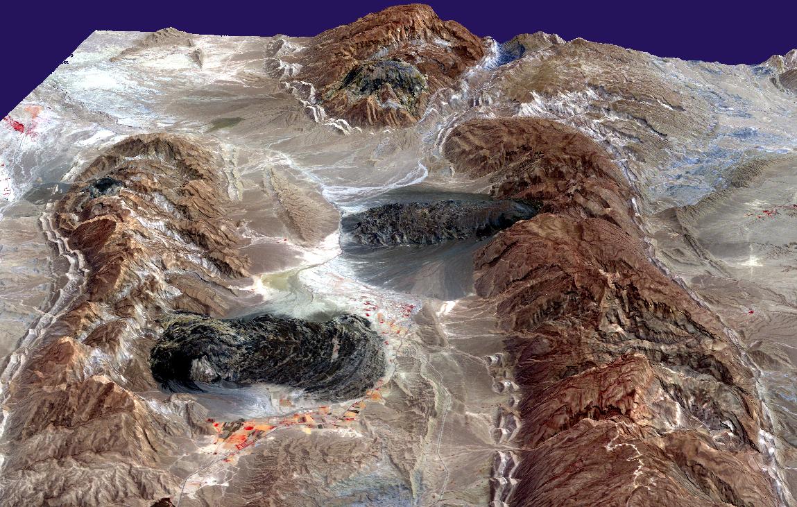
197:. Gravity has caused the salt to flow like glaciers into adjacent valleys. The resulting tongue-shaped bodies are more than 5 kilometers long, with repeating bow-shaped ridges separated by crevasse-like gullies and with steep sides and fronts. The darker tones are due to clays brought up with the salt, as well as the probable accumulation of airborne dust. This
492:"}},"text\/plain":{"en":{"":"applies to jurisdiction"}}},"{\"value\":{\"entity-type\":\"item\",\"numeric-id\":30,\"id\":\"Q30\"},\"type\":\"wikibase-entityid\"}":{"text\/html":{"en":{"P1001":"
484:"}},"text\/plain":{"en":{"":"copyright status"}}},"{\"value\":{\"entity-type\":\"item\",\"numeric-id\":19652,\"id\":\"Q19652\"},\"type\":\"wikibase-entityid\"}":{"text\/html":{"en":{"P6216":"
488:"}},"text\/plain":{"en":{"P6216":"public domain"}}},"{\"value\":{\"entity-type\":\"property\",\"numeric-id\":1001,\"id\":\"P1001\"},\"type\":\"wikibase-entityid\"}":{"text\/html":{"en":{"":"
614:
137:
424:
143:
501:
485:
615:
489:
481:
577:
497:
493:
779:
57:
53:
47:
102:
70:
504:"}},"text\/plain":{"en":{"P459":"work of the federal government of the United States"}}}}": -->
201:
perspective view was created by draping a band 3-2-1 (RGB) image over an ASTER-derived
Digital Elevation Model (2x vertical exaggeration).
403:
joint project implies that all materials created by its probe are copyrighted and require permission for commercial non-educational use.
238:
352:
562:
153:
982:
This file contains additional information, probably added from the digital camera or scanner used to create or digitize it.
527:
420:
400:
625:
540:
511:
378:
587:
555:
470:
547:
410:
363:
985:
If the file has been modified from its original state, some details may not fully reflect the modified file.
761:
693:
688:
428:
61:
42:
431:
states that all of the images in the photo gallery are in the public domain "Unless otherwise noted."
874:
869:
737:
The following pages on the
English Knowledge use this file (pages on other projects are not listed):
727:
perspective view was created by draping a band 3-2-1 (RGB) image over an ASTER-derived
Digital Eleva
374:
110:
959:
404:
359:
8:
415:
391:
385:
219:
307:
303:
159:
190:
97:
460:
746:
720:
704:
969:
934:
924:
298:. NASA copyright policy states that "NASA material is not protected by copyright
290:
186:
756:
716:
194:
635:
597:
521:
311:
751:
348:
182:
712:
661:
Click on a date/time to view the file as it appeared at that time.
382:
377:
data may be copyrighted if they are not explicitly produced by the
904:
799:
145:
909:
741:
198:
229:
NASA/GSFC/MITI/ERSDAC/JAROS, and U.S./Japan ASTER Science Team
944:
914:
884:
724:
295:
894:
949:
859:
834:
814:
844:
138:
27° 31′ 48″ N, 54° 31′ 12″ E
358:
The NASA website hosts a large number of images from the
209:
85:
454:
Add a one-line explanation of what this file represents
839:
294:
in the United States because it was solely created by
220:
http://earthobservatory.nasa.gov/IOTD/view.php?id=4168
824:
735:
789:
770:
659:
109:
Commons is a freely licensed media file repository.
854:
809:
563:
work of the federal government of the United States
502:
work of the federal government of the United States
366:, and other non-American space agencies. These are
75:(1,149 × 731 pixels, file size: 231 KB, MIME type:
351:, insignia and emblems is restricted per U.S. law
711:{{Information | Description=Satellite imagery of
90:
233:
205:
174:
225:
215:
14:
772:The following other wikis use this file:
189:, visible as darkish irregular patches,
152:View this and other nearby images on:
281:
121:
423:(NSSDC) site has been known to host
414:(APOD) web site may be copyrighted.
276:
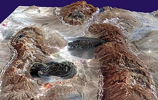
177:SaltGlaciers ZagrosMtns 20010810.jpg
128:
652:
13:
980:
459:
453:
421:National Space Science Data Center
329:
318:
122:
68:
1006:
987:
458:
736:
444:
280:
158:
144:
89:
31:
21:
441:
767:
656:
440:
26:
1:
626:coordinates of depicted place
616:coordinates of depicted place
36:
732:
466:Items portrayed in this file
411:Astronomy Picture of the Day
252:
245:US government, public domain
7:
977:
786:Usage on ast.wikipedia.org
10:
1011:
966:Usage on uk.wikipedia.org
956:Usage on sr.wikipedia.org
941:Usage on sh.wikipedia.org
931:Usage on ru.wikipedia.org
921:Usage on ja.wikipedia.org
901:Usage on it.wikipedia.org
891:Usage on hr.wikipedia.org
881:Usage on fr.wikipedia.org
866:Usage on fa.wikipedia.org
851:Usage on es.wikipedia.org
831:Usage on de.wikipedia.org
821:Usage on cs.wikipedia.org
806:Usage on ca.wikipedia.org
796:Usage on bs.wikipedia.org
776:Usage on ar.wikipedia.org
762:User:Mpangoolakchi/sandbox
308:NASA copyright policy page
171:
124:
653:
16:
548:United States of America
494:United States of America
443:
96:This is a file from the
41:
723:of southern Iran. This
710:
541:applies to jurisdiction
490:applies to jurisdiction
408:Images featured on the
208:
100:. Information from its
641:27°31'48"N, 54°31'12"E
375:Hubble Space Telescope
334:
323:
193:, southern Iran, near
164:27.530000; 54.520000
103:description page there
46:Size of this preview:
401:SOHO (ESA & NASA)
370:in the public domain.
333:
322:
181:Satellite imagery of
905:Formazione di Hormuz
800:Geomorfologija Irana
780:تشكيل هرمز الجيولوجي
689:16:49, 27 April 2006
556:determination method
498:determination method
364:Russian space agency
312:JPL Image Use Policy
288:This file is in the
425:copyrighted content
373:Materials based on
52:Other resolutions:
910:Ghiacciaio di sale
721:w:Zagros Mountains
335:
324:
62:1,149 × 731 pixels
998:
997:
768:Global file usage
730:
452:
438:
437:
429:photo gallery FAQ
342:
304:Template:PD-USGov
275:
274:
249:
248:
242:
239:Reusing this file
169:
168:
118:
117:
98:Wikimedia Commons
32:Global file usage
1002:
988:
945:Geografija Irana
915:Tettonica salina
747:Hormuz Formation
701:
663:
565:
560:
550:
545:
512:copyright status
482:copyright status
450:
394:
388:
338:
332:
321:
284:
283:
277:
271:
268:
265:
262:
257:
256:
236:
211:
191:Zagros Mountains
178:
172:
165:
162:
148:
147:
141:
140:
129:
114:
93:
92:
86:
80:
78:
65:
58:640 × 407 pixels
54:320 × 204 pixels
48:800 × 509 pixels
1010:
1009:
1005:
1004:
1003:
1001:
1000:
999:
976:
895:Zemljopis Irana
766:
738:
731:
717:w:salt glaciers
707:
699:
655:
654:
651:
650:
649:
648:
647:
646:
645:
644:
642:
632:
631:
630:
628:
613:
612:
611:
610:
609:
608:
607:
606:
604:
594:
593:
592:
590:
575:
574:
573:
572:
571:
570:
569:
568:
567:
566:
561:
558:
552:
551:
546:
543:
534:
533:
532:
530:
518:
517:
516:
514:
479:
478:
477:
476:
475:
473:
457:
456:
455:
434:
392:
386:
368:not necessarily
330:
319:
269:
266:
263:
260:
255:
250:
176:
163:
136:
135:
132:Object location
127:
120:
119:
108:
107:
106:is shown below.
82:
76:
74:
67:
66:
51:
12:
11:
5:
1008:
996:
995:
992:
979:
975:
974:
973:
972:
964:
963:
962:
954:
953:
952:
950:Slani ledenjak
947:
939:
938:
937:
929:
928:
927:
919:
918:
917:
912:
907:
899:
898:
897:
889:
888:
887:
879:
878:
877:
872:
864:
863:
862:
860:Glaciar salino
857:
849:
848:
847:
842:
837:
835:Zagros-Gebirge
829:
828:
827:
819:
818:
817:
815:Glacera salina
812:
804:
803:
802:
794:
793:
792:
784:
783:
782:
769:
765:
764:
759:
754:
749:
744:
734:
729:
728:
709:
705:
702:
696:
691:
686:
682:
681:
678:
675:
672:
669:
666:
658:
643:
640:
638:
637:
636:
634:
633:
629:
624:
622:
621:
620:
619:
617:
605:
603:10 August 2001
602:
600:
599:
598:
596:
595:
591:
586:
584:
583:
582:
581:
579:
554:
553:
539:
538:
537:
536:
535:
531:
526:
524:
523:
522:
520:
519:
515:
510:
508:
507:
506:
505:
503:
499:
495:
491:
487:
483:
474:
469:
467:
464:
463:
462:
461:
449:
448:
445:
442:
436:
435:
433:
432:
417:
406:
397:
371:
356:
344:
336:
326:
325:
316:
285:
273:
272:
254:
251:
247:
246:
243:
231:
230:
227:
223:
222:
217:
213:
212:
210:10 August 2001
207:
203:
202:
179:
170:
167:
166:
156:
150:
133:
126:
123:
116:
115:
94:
84:
83:
45:
40:
39:
34:
29:
24:
19:
9:
6:
4:
3:
2:
1007:
993:
990:
989:
986:
983:
971:
968:
967:
965:
961:
958:
957:
955:
951:
948:
946:
943:
942:
940:
936:
933:
932:
930:
926:
923:
922:
920:
916:
913:
911:
908:
906:
903:
902:
900:
896:
893:
892:
890:
886:
883:
882:
880:
876:
873:
871:
868:
867:
865:
861:
858:
856:
853:
852:
850:
846:
845:Salzgletscher
843:
841:
838:
836:
833:
832:
830:
826:
823:
822:
820:
816:
813:
811:
808:
807:
805:
801:
798:
797:
795:
791:
788:
787:
785:
781:
778:
777:
775:
774:
773:
763:
760:
758:
755:
753:
750:
748:
745:
743:
740:
739:
726:
722:
718:
714:
708:
703:
697:
695:
692:
690:
687:
684:
683:
679:
676:
673:
670:
667:
665:
664:
662:
639:
627:
623:
601:
589:
585:
564:
557:
549:
542:
529:
528:public domain
525:
513:
509:
486:public domain
472:
468:
465:
446:
439:
430:
426:
422:
418:
416:
413:
412:
407:
405:
402:
398:
395:
393:{{Cc-Hubble}}
389:
387:{{PD-Hubble}}
383:
380:
376:
372:
369:
365:
361:
357:
354:
350:
346:
345:
343:
341:
337:
328:
327:
317:
315:
313:
309:
305:
301:
297:
293:
292:
291:public domain
286:
279:
278:
264:Public domain
261:Public domain
259:
258:
244:
240:
235:
232:
228:
224:
221:
218:
214:
204:
200:
196:
192:
188:
187:salt glaciers
184:
180:
173:
161:
157:
155:
154:OpenStreetMap
151:
149:
139:
134:
131:
130:
112:
105:
104:
99:
95:
88:
87:
81:
72:
71:Original file
63:
59:
55:
49:
44:
38:
35:
33:
30:
28:
25:
23:
20:
18:
15:
984:
981:
771:
757:Salt glacier
713:w:salt domes
698:1,149 × 731
660:
657:File history
409:
367:
339:
300:unless noted
299:
289:
287:
111:You can help
101:
69:
22:File history
885:Dôme de sel
706:Holly Cheng
353:14 CFR 1221
175:Description
991:_error
875:سازند هرمز
870:یخچال نمکی
752:Karmowstaj
733:File usage
674:Dimensions
349:NASA logos
234:Permission
195:Karmowstaj
183:salt domes
77:image/jpeg
27:File usage
960:Сона дома
840:Salzstock
671:Thumbnail
668:Date/Time
588:inception
578:inception
384:See also
340:Warnings:
253:Licensing
978:Metadata
825:Geologie
700:(231 KB)
447:Captions
302:". (See
37:Metadata
725:w:ASTER
719:in the
685:current
680:Comment
471:depicts
451:English
347:Use of
125:Summary
73:
970:Діапір
935:Диапир
855:Zagros
810:Zagros
790:Zagros
742:Diapir
427:. Its
360:Soviet
226:Author
216:Source
142:
379:STScI
270:false
267:false
199:Aster
925:岩塩氷河
715:and
677:User
419:The
399:The
390:and
296:NASA
206:Date
185:and
17:File
310:or
559::
544::
314:.)
306:,
60:|
56:|
50:.
994:0
396:.
381:.
362:/
355:.
241:)
237:(
113:.
79:)
64:.
Text is available under the Creative Commons Attribution-ShareAlike License. Additional terms may apply.