953:"}},"text\/plain":{"en":{"":"coordinates of the point of view"}}},"{\"value\":{\"latitude\":54.56395,\"longitude\":-1.8695,\"altitude\":null,\"precision\":1.0e-5,\"globe\":\"http:\\\/\\\/www.wikidata.org\\\/entity\\\/Q2\"},\"type\":\"globecoordinate\"}":{"text\/html":{"en":{"P1259":"54\u00b033'50.22"N, 1\u00b052'10.20"W"}},"text\/plain":{"en":{"P1259":"54\u00b033'50.22\"N, 1\u00b052'10.20\"W"}}},"{\"value\":{\"entity-type\":\"property\",\"numeric-id\":7787,\"id\":\"P7787\"},\"type\":\"wikibase-entityid\"}":{"text\/html":{"en":{"":"
1021:"}},"text\/plain":{"en":{"":"coordinates of depicted place"}}},"{\"value\":{\"latitude\":54.56422,\"longitude\":-1.8695,\"altitude\":null,\"precision\":1.0e-5,\"globe\":\"http:\\\/\\\/www.wikidata.org\\\/entity\\\/Q2\"},\"type\":\"globecoordinate\"}":{"text\/html":{"en":{"P9149":"54\u00b033'51.19"N, 1\u00b052'10.20"W"}},"text\/plain":{"en":{"P9149":"54\u00b033'51.19\"N, 1\u00b052'10.20\"W"}}},"{\"value\":{\"entity-type\":\"property\",\"numeric-id\":7787,\"id\":\"P7787\"},\"type\":\"wikibase-entityid\"}":{"text\/html":{"en":{"":"
613:"}},"text\/plain":{"en":{"":"author name string"}}},"{\"value\":\"Hugh Mortimer\",\"type\":\"string\"}":{"text\/html":{"en":{"P2093":"Hugh Mortimer"}},"text\/plain":{"en":{"P2093":"Hugh Mortimer"}}},"{\"value\":{\"entity-type\":\"property\",\"numeric-id\":3831,\"id\":\"P3831\"},\"type\":\"wikibase-entityid\"}":{"text\/html":{"en":{"":"
796:"}},"text\/plain":{"en":{"":"inception"}}},"{\"value\":{\"time\":\"+2006-07-13T00:00:00Z\",\"timezone\":0,\"before\":0,\"after\":0,\"precision\":11,\"calendarmodel\":\"http:\\\/\\\/www.wikidata.org\\\/entity\\\/Q1985727\"},\"type\":\"time\"}":{"text\/html":{"en":{"P571":"13 July 2006"}},"text\/plain":{"en":{"P571":"13 July 2006"}}}}": -->
830:
597:
232:
1017:
274:
224:
296:
246:
317:
355:
360:
72:
609:"}},"text\/plain":{"en":{"P2699":"https:\/\/www.geograph.org.uk\/profile\/5255"}}},"{\"value\":{\"entity-type\":\"property\",\"numeric-id\":2093,\"id\":\"P2093\"},\"type\":\"wikibase-entityid\"}":{"text\/html":{"en":{"":"
838:"}},"text\/plain":{"en":{"P7482":"file available on the internet"}}},"{\"value\":{\"entity-type\":\"property\",\"numeric-id\":137,\"id\":\"P137\"},\"type\":\"wikibase-entityid\"}":{"text\/html":{"en":{"":"
846:"}},"text\/plain":{"en":{"P137":"Geograph Britain and Ireland"}}},"{\"value\":{\"entity-type\":\"property\",\"numeric-id\":7384,\"id\":\"P7384\"},\"type\":\"wikibase-entityid\"}":{"text\/html":{"en":{"":"
617:"}},"text\/plain":{"en":{"":"object of statement has role"}}},"{\"value\":{\"entity-type\":\"item\",\"numeric-id\":33231,\"id\":\"Q33231\"},\"type\":\"wikibase-entityid\"}":{"text\/html":{"en":{"P3831":"
1127:
752:"}},"text\/plain":{"en":{"":"copyright license"}}},"{\"value\":{\"entity-type\":\"item\",\"numeric-id\":19068220,\"id\":\"Q19068220\"},\"type\":\"wikibase-entityid\"}":{"text\/html":{"en":{"P275":"
708:"}},"text\/plain":{"en":{"":"copyright status"}}},"{\"value\":{\"entity-type\":\"item\",\"numeric-id\":50423863,\"id\":\"Q50423863\"},\"type\":\"wikibase-entityid\"}":{"text\/html":{"en":{"P6216":"
834:"}},"text\/plain":{"en":{"":"source of file"}}},"{\"value\":{\"entity-type\":\"item\",\"numeric-id\":74228490,\"id\":\"Q74228490\"},\"type\":\"wikibase-entityid\"}":{"text\/html":{"en":{"P7482":"
842:"}},"text\/plain":{"en":{"":"operator"}}},"{\"value\":{\"entity-type\":\"item\",\"numeric-id\":1503119,\"id\":\"Q1503119\"},\"type\":\"wikibase-entityid\"}":{"text\/html":{"en":{"P137":"
1025:"}},"text\/plain":{"en":{"":"heading"}}},"{\"value\":{\"amount\":\"+0\",\"unit\":\"http:\\\/\\\/www.wikidata.org\\\/entity\\\/Q28390\"},\"type\":\"quantity\"}":{"text\/html":{"en":{"P7787":"0
957:"}},"text\/plain":{"en":{"":"heading"}}},"{\"value\":{\"amount\":\"+0\",\"unit\":\"http:\\\/\\\/www.wikidata.org\\\/entity\\\/Q28390\"},\"type\":\"quantity\"}":{"text\/html":{"en":{"P7787":"0
854:"}},"text\/plain":{"en":{"P7384":"201479"}}},"{\"value\":{\"entity-type\":\"property\",\"numeric-id\":973,\"id\":\"P973\"},\"type\":\"wikibase-entityid\"}":{"text\/html":{"en":{"":"
601:"}},"text\/plain":{"en":{"":"creator"}}},"{\"value\":{\"entity-type\":\"property\",\"numeric-id\":2699,\"id\":\"P2699\"},\"type\":\"wikibase-entityid\"}":{"text\/html":{"en":{"":"
704:
605:"}},"text\/plain":{"en":{"":"URL"}}},"{\"value\":\"https:\\\/\\\/www.geograph.org.uk\\\/profile\\\/5255\",\"type\":\"string\"}":{"text\/html":{"en":{"P2699":"
265:
215:
850:"}},"text\/plain":{"en":{"":"geograph.org.uk image ID"}}},"{\"value\":\"201479\",\"type\":\"string\"}":{"text\/html":{"en":{"P7384":"
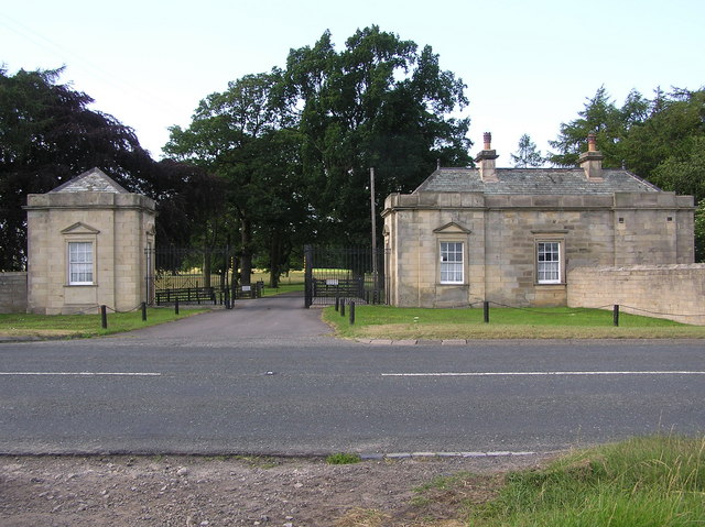
1144:== {{int:filedesc}} == {{Information |description={{en|1=South Lodge : Streatlam Park. On the A688. The site of Streatlam Castle a Mansion built by Sir William Bowes about 1718 on the site of the 15th century Castle. Demolished in 1927, and the remains (o
126:
South Lodge : Streatlam Park. On the A688. The site of
Streatlam Castle a Mansion built by Sir William Bowes about 1718 on the site of the 15th century Castle. Demolished in 1927, and the remains (of the original castle) blown up by the Army in
407:– You must give appropriate credit, provide a link to the license, and indicate if changes were made. You may do so in any reasonable manner, but not in any way that suggests the licensor endorses you or your use.
279:
229:
83:
51:
456:
851:
835:
753:
709:
843:
618:
1022:
1018:
954:
950:
847:
831:
705:
614:
610:
602:
859:
855:
839:
793:
749:
606:
598:
473:
1137:
756:"}},"text\/plain":{"en":{"P275":"Creative Commons Attribution-ShareAlike 2.0 Generic"}}}}": -->
862:"}},"text\/plain":{"en":{"P973":"https:\/\/www.geograph.org.uk\/photo\/201479"}}}}": -->
885:
779:
735:
289:
239:
1126:
1121:
42:
905:
324:
1189:
This file contains additional information, probably added from the digital camera or scanner used to create or digitize it.
414:
690:
1063:
1036:
995:
968:
913:
869:
719:
683:
670:
655:
549:
928:
898:
803:
763:
628:
587:
496:
488:
1334:
370:
1192:
If the file has been modified from its original state, some details may not fully reflect the modified file.
469:
413:– If you remix, transform, or build upon the material, you must distribute your contributions under the
331:
on the
Geograph website for the photographer's contact details. The copyright on this image is owned by
621:"}},"text\/plain":{"en":{"P3831":"photographer"}}}}": -->
712:"}},"text\/plain":{"en":{"P6216":"copyrighted"}}}}": -->
1154:
The following pages on the
English Knowledge use this file (pages on other projects are not listed):
1029:"}},"text\/plain":{"en":{"P7787":"0 degree"}}}}": -->
961:"}},"text\/plain":{"en":{"P7787":"0 degree"}}}}": -->
1209:
477:
91:
184:
462:
Remove redundant categories and try to put this image in the most specific category/categories
1361:
935:
920:
662:
367:
168:
540:
8:
1397:
1303:
311:
544:
536:
532:
528:
524:
520:
516:
512:
508:
504:
295:
245:
1462:
336:
78:
577:
1158:
1433:
1379:
1226:
1472:
1443:
1266:
157:
147:
1407:
1046:
978:
879:
813:
773:
729:
638:
316:
1246:
328:
1482:
1236:
1094:
Click on a date/time to view the file as it appeared at that time.
281:
231:
1219:
266:
54° 33′ 51.2″ N, 1° 52′ 10″ W
216:
54° 33′ 50.2″ N, 1° 52′ 10″ W
116:
South Lodge , Streatlam Park - geograph.org.uk - 201479.jpg
52:
South_Lodge_,_Streatlam_Park_-_geograph.org.uk_-_201479.jpg
136:
66:
571:
Add a one-line explanation of what this file represents
1176:
476:
combined with a database. You can also have a look at
468:
The location categories are based on information from
1152:
1167:
1092:
90:
Commons is a freely licensed media file repository.
780:
Creative
Commons Attribution-ShareAlike 2.0 Generic
754:
Creative
Commons Attribution-ShareAlike 2.0 Generic
56:(640 × 479 pixels, file size: 104 KB, MIME type:
1402:Flash did not fire, compulsory flash suppression
1329:Creative program (biased toward depth of field)
453:The categories of this image should be checked.
424:https://creativecommons.org/licenses/by-sa/2.0
71:
430:Creative Commons Attribution-Share Alike 2.0
348:
132:
113:
860:https:\/\/www.geograph.org.uk\/photo\/201479
607:https:\/\/www.geograph.org.uk\/profile\/5255
153:
142:
14:
1026:
958:
390:– to copy, distribute and transmit the work
1169:The following other wikis use this file:
936:https://www.geograph.org.uk/photo/201479
663:https://www.geograph.org.uk/profile/5255
495:This image was uploaded as part of the
288:View this and other nearby images on:
238:View this and other nearby images on:
483:The topic category from Geograph was
191:
102:
335:and is licensed for reuse under the
256:
206:
1085:
371:Attribution-Share Alike 2.0 Generic
359:
354:
339:Attribution-ShareAlike 2.0 license.
13:
1187:
576:
570:
345:
322:
120:
103:
49:
1499:
1194:
575:
199:South Lodge : Streatlam Park
180:South Lodge : Streatlam Park
1257:Date and time of data generation
1153:
969:coordinates of the point of view
951:coordinates of the point of view
561:
446:
401:Under the following conditions:
366:This file is licensed under the
358:
353:
347:
315:
294:
280:
272:
244:
230:
222:
70:
31:
21:
1201:OLYMPUS DIGITAL CAMERA
558:
121:
46:No higher resolution available.
1164:
1089:
886:file available on the internet
836:file available on the internet
557:
323:This image was taken from the
26:
1:
1037:coordinates of depicted place
1019:coordinates of depicted place
36:
1149:
906:Geograph Britain and Ireland
844:Geograph Britain and Ireland
684:object of statement has role
615:object of statement has role
583:Items portrayed in this file
307:
7:
1345:Date and time of digitizing
1184:
1052:54°33'51.19"N, 1°52'10.20"W
984:54°33'50.22"N, 1°52'10.20"W
10:
1504:
1173:Usage on www.wikidata.org
415:same or compatible license
271:
221:
197:Hugh Mortimer /
178:Hugh Mortimer /
110:
105:
1310:File change date and time
1086:
16:
914:geograph.org.uk image ID
848:geograph.org.uk image ID
560:
478:this tool from mysociety
444:
443:
381:
77:This is a file from the
41:
1417:Custom image processing
1210:OLYMPUS OPTICAL CO.,LTD
1143:
474:this OpenStreetMap tool
169:required by the license
135:
81:. Information from its
1353:Image compression mode
1122:21:21, 31 January 2010
329:this photograph's page
300:54.564220; -1.869500
250:54.563950; -1.869500
84:description page there
1371:Maximum land aperture
1284:Horizontal resolution
497:Geograph batch upload
487:(find similar images
465:Remove this template
1348:16:14, 13 July 2006
1318:Y and C positioning
1313:17:50, 13 July 2006
1304:CAMEDIA Master 4.10
1292:Vertical resolution
1260:16:14, 13 July 2006
1231:1/160 sec (0.00625)
1206:Camera manufacturer
541:português do Brasil
396:– to adapt the work
1454:Scene capture type
1438:Auto white balance
671:author name string
611:author name string
470:this geonames tool
1491:
1490:
1165:Global file usage
1147:
1028:
960:
764:copyright license
750:copyright license
569:
552:
499:
344:
343:
327:collection. See
305:
304:
255:
254:
204:
203:
172:
99:
98:
79:Wikimedia Commons
32:Global file usage
1495:
1326:Exposure Program
1195:
1159:Streatlam Castle
1134:
1096:
1074:
1073:
1068:
1006:
1005:
1000:
938:
933:
929:described at URL
923:
918:
908:
903:
856:described at URL
720:copyright status
706:copyright status
693:
688:
678:
675:
665:
660:
567:
553:
548:
494:
451:
450:
449:
437:
434:
431:
428:
425:
417:as the original.
379:
368:Creative Commons
362:
361:
357:
356:
351:
350:
337:Creative Commons
325:Geograph project
319:
312:
301:
298:
284:
283:
277:
276:
275:
269:
268:
257:
251:
248:
234:
233:
227:
226:
225:
219:
218:
207:
166:
138:
125:
117:
111:
95:
74:
73:
67:
61:
59:
1503:
1502:
1498:
1497:
1496:
1494:
1493:
1492:
1374:3 APEX (f/2.83)
1183:
1163:
1155:
1148:
1140:
1132:
1088:
1087:
1084:
1083:
1082:
1081:
1080:
1079:
1078:
1077:
1076:
1075:
1071:
1069:
1066:
1057:
1056:
1055:
1053:
1043:
1042:
1041:
1039:
1016:
1015:
1014:
1013:
1012:
1011:
1010:
1009:
1008:
1007:
1003:
1001:
998:
989:
988:
987:
985:
975:
974:
973:
971:
948:
947:
946:
945:
944:
943:
942:
941:
940:
939:
934:
931:
925:
924:
919:
916:
910:
909:
904:
901:
892:
891:
890:
888:
876:
875:
874:
872:
829:
828:
827:
826:
825:
824:
823:
822:
820:
810:
809:
808:
806:
791:
790:
789:
788:
787:
786:
785:
784:
782:
770:
769:
768:
766:
747:
746:
745:
744:
743:
742:
741:
740:
738:
726:
725:
724:
722:
703:
702:
701:
700:
699:
698:
697:
696:
695:
694:
689:
686:
680:
679:
676:
673:
667:
666:
661:
658:
649:
648:
647:
645:
635:
634:
633:
631:
596:
595:
594:
593:
592:
590:
574:
573:
572:
555:
503:
500:
457:Check them now!
447:
445:
439:
438:
435:
432:
429:
426:
423:
422:
380:
377:
374:
363:
340:
310:
299:
273:
264:
263:
260:Object location
249:
223:
214:
213:
210:Camera location
205:
194:
187:
175:
148:geograph.org.uk
128:
115:
108:
101:
100:
89:
88:
87:is shown below.
63:
57:
55:
48:
47:
12:
11:
5:
1501:
1489:
1488:
1485:
1479:
1478:
1475:
1469:
1468:
1465:
1459:
1458:
1455:
1451:
1450:
1447:
1440:
1439:
1436:
1430:
1429:
1426:
1422:
1421:
1420:Custom process
1418:
1414:
1413:
1410:
1404:
1403:
1400:
1394:
1393:
1390:
1386:
1385:
1382:
1376:
1375:
1372:
1368:
1367:
1364:
1358:
1357:
1354:
1350:
1349:
1346:
1342:
1341:
1338:
1331:
1330:
1327:
1323:
1322:
1319:
1315:
1314:
1311:
1307:
1306:
1301:
1297:
1296:
1293:
1289:
1288:
1285:
1281:
1280:
1277:
1273:
1272:
1269:
1262:
1261:
1258:
1254:
1253:
1250:
1243:
1242:
1239:
1233:
1232:
1229:
1223:
1222:
1217:
1213:
1212:
1207:
1203:
1202:
1199:
1186:
1182:
1181:
1180:
1179:
1166:
1162:
1161:
1151:
1146:
1145:
1142:
1138:
1135:
1129:
1124:
1119:
1115:
1114:
1111:
1108:
1105:
1102:
1099:
1091:
1062:
1061:
1060:
1059:
1058:
1054:
1051:
1049:
1048:
1047:
1045:
1044:
1040:
1035:
1033:
1032:
1031:
1030:
1024:
1020:
994:
993:
992:
991:
990:
986:
983:
981:
980:
979:
977:
976:
972:
967:
965:
964:
963:
962:
956:
952:
927:
926:
912:
911:
897:
896:
895:
894:
893:
889:
884:
882:
881:
880:
878:
877:
873:
870:source of file
868:
866:
865:
864:
863:
861:
857:
853:
849:
845:
841:
837:
833:
832:source of file
821:
818:
816:
815:
814:
812:
811:
807:
802:
800:
799:
798:
797:
795:
783:
778:
776:
775:
774:
772:
771:
767:
762:
760:
759:
758:
757:
755:
751:
739:
734:
732:
731:
730:
728:
727:
723:
718:
716:
715:
714:
713:
711:
707:
682:
681:
669:
668:
654:
653:
652:
651:
650:
646:
643:
641:
640:
639:
637:
636:
632:
627:
625:
624:
623:
622:
620:
616:
612:
608:
604:
600:
591:
586:
584:
581:
580:
579:
578:
566:
565:
562:
559:
493:
492:
481:
466:
463:
421:
420:
419:
418:
408:
399:
398:
397:
391:
384:You are free:
375:
365:
364:
346:
342:
341:
320:
309:
306:
303:
302:
292:
286:
261:
253:
252:
242:
236:
211:
202:
201:
195:
192:
189:
188:
183:
176:
173:
161:
160:
155:
151:
150:
144:
140:
139:
134:
130:
129:
118:
109:
107:
104:
97:
96:
75:
65:
64:
45:
40:
39:
34:
29:
24:
19:
9:
6:
4:
3:
2:
1500:
1486:
1484:
1481:
1480:
1476:
1474:
1471:
1470:
1466:
1464:
1461:
1460:
1456:
1453:
1452:
1448:
1445:
1442:
1441:
1437:
1435:
1434:White balance
1432:
1431:
1428:Auto exposure
1427:
1425:Exposure mode
1424:
1423:
1419:
1416:
1415:
1411:
1409:
1406:
1405:
1401:
1399:
1396:
1395:
1391:
1388:
1387:
1383:
1381:
1380:Metering mode
1378:
1377:
1373:
1370:
1369:
1365:
1363:
1362:Exposure bias
1360:
1359:
1355:
1352:
1351:
1347:
1344:
1343:
1339:
1336:
1333:
1332:
1328:
1325:
1324:
1320:
1317:
1316:
1312:
1309:
1308:
1305:
1302:
1300:Software used
1299:
1298:
1294:
1291:
1290:
1286:
1283:
1282:
1278:
1275:
1274:
1270:
1268:
1264:
1263:
1259:
1256:
1255:
1251:
1248:
1245:
1244:
1240:
1238:
1235:
1234:
1230:
1228:
1227:Exposure time
1225:
1224:
1221:
1218:
1215:
1214:
1211:
1208:
1205:
1204:
1200:
1197:
1196:
1193:
1190:
1178:
1175:
1174:
1172:
1171:
1170:
1160:
1157:
1156:
1141:
1136:
1130:
1128:
1125:
1123:
1120:
1117:
1116:
1112:
1109:
1106:
1103:
1100:
1098:
1097:
1095:
1065:
1050:
1038:
1034:
997:
982:
970:
966:
937:
930:
922:
915:
907:
900:
887:
883:
871:
867:
817:
805:
801:
781:
777:
765:
761:
737:
733:
721:
717:
692:
685:
677:Hugh Mortimer
672:
664:
657:
642:
630:
626:
589:
585:
582:
563:
556:
554:
551:
546:
542:
538:
534:
530:
526:
522:
518:
514:
510:
506:
501:
498:
490:
486:
482:
479:
475:
471:
467:
464:
461:
460:
459:
458:
454:
442:
441:
427:CC BY-SA 2.0
416:
412:
409:
406:
403:
402:
400:
395:
392:
389:
386:
385:
383:
382:
378:Hugh Mortimer
376:Attribution:
372:
369:
352:
338:
334:
333:Hugh Mortimer
330:
326:
321:
318:
314:
313:
297:
293:
291:
290:OpenStreetMap
287:
285:
267:
262:
259:
258:
247:
243:
241:
240:OpenStreetMap
237:
235:
217:
212:
209:
208:
200:
196:
190:
186:
182: /
181:
177:
170:
165:
163:
162:
159:
158:Hugh Mortimer
156:
152:
149:
145:
141:
131:
124:
119:
112:
93:
86:
85:
80:
76:
69:
68:
62:
53:
44:
38:
35:
33:
30:
28:
25:
23:
20:
18:
15:
1444:Digital zoom
1389:Light source
1267:focal length
1216:Camera model
1191:
1188:
1168:
1093:
1090:File history
819:13 July 2006
691:photographer
619:photographer
502:
484:
455:
452:
440:
410:
404:
393:
387:
332:
270:
220:
198:
185:CC BY-SA 2.0
179:
137:13 July 2006
122:
92:You can help
82:
50:
22:File history
1408:Color space
1276:Orientation
1198:Image title
1139:GeographBot
736:copyrighted
710:copyrighted
489:at Geograph
411:share alike
405:attribution
164:Attribution
114:Description
1473:Saturation
1150:File usage
1131:640 × 479
1107:Dimensions
644:some value
529:македонски
58:image/jpeg
27:File usage
1483:Sharpness
1247:ISO speed
1177:Q16248224
1104:Thumbnail
1101:Date/Time
804:inception
794:inception
537:português
308:Licensing
193:InfoField
174:InfoField
123:English:
1463:Contrast
1457:Standard
1321:Co-sited
1237:F-number
1185:Metadata
1133:(104 KB)
899:operator
840:operator
564:Captions
547: |
543: |
539: |
535: |
531: |
527: |
523: |
519: |
515: |
513:français
511: |
507: |
394:to remix
388:to share
373:license.
37:Metadata
1392:Unknown
1384:Pattern
1337:version
1118:current
1113:Comment
1064:heading
1023:heading
996:heading
955:heading
629:creator
599:creator
588:depicts
568:English
505:English
106:Summary
54:
1487:Normal
1477:Normal
1467:Normal
1295:72 dpi
1287:72 dpi
1279:Normal
1271:6.3 mm
1249:rating
1220:C750UZ
1072:degree
1027:degree
1004:degree
959:degree
921:201479
852:201479
545:Türkçe
533:മലയാളം
525:magyar
517:galego
278:
228:
154:Author
143:Source
1446:ratio
1398:Flash
1265:Lens
521:עברית
509:suomi
485:Lodge
146:From
127:1956.
1412:sRGB
1335:Exif
1110:User
472:and
436:true
433:true
133:Date
17:File
1340:2.2
1241:f/4
656:URL
603:URL
550:+/−
1252:50
1070:0
1067::
1002:0
999::
932::
917::
902::
687::
674::
659::
1449:0
1366:0
1356:2
491:)
480:.
171:)
167:(
94:.
60:)
Text is available under the Creative Commons Attribution-ShareAlike License. Additional terms may apply.
_region:GB-GBN_heading:0.00&language=en)
_region:GB-GBN_heading:0.00&language=en)
