43:
277:
834:"}},"text\/plain":{"en":{"":"inception"}}},"{\"value\":{\"time\":\"+2009-01-01T00:00:00Z\",\"timezone\":0,\"before\":0,\"after\":0,\"precision\":10,\"calendarmodel\":\"http:\\\/\\\/www.wikidata.org\\\/entity\\\/Q1985727\"},\"type\":\"time\"}":{"text\/html":{"en":{"P571":"January 2009"}},"text\/plain":{"en":{"P571":"January 2009"}}}}": -->
550:
213:
757:
172:
435:
95:
700:"}},"text\/plain":{"en":{"P275":"attribution only license"}}},"{\"value\":{\"entity-type\":\"item\",\"numeric-id\":14946043,\"id\":\"Q14946043\"},\"type\":\"wikibase-entityid\"}":{"text\/html":{"en":{"P275":"
566:"}},"text\/plain":{"en":{"P275":"attribution only license"}}},"{\"value\":{\"entity-type\":\"property\",\"numeric-id\":518,\"id\":\"P518\"},\"type\":\"wikibase-entityid\"}":{"text\/html":{"en":{"":"
696:"}},"text\/plain":{"en":{"":"copyright license"}}},"{\"value\":{\"entity-type\":\"item\",\"numeric-id\":98923445,\"id\":\"Q98923445\"},\"type\":\"wikibase-entityid\"}":{"text\/html":{"en":{"P275":"
562:"}},"text\/plain":{"en":{"":"copyright license"}}},"{\"value\":{\"entity-type\":\"item\",\"numeric-id\":98923445,\"id\":\"Q98923445\"},\"type\":\"wikibase-entityid\"}":{"text\/html":{"en":{"P275":"
554:"}},"text\/plain":{"en":{"":"copyright status"}}},"{\"value\":{\"entity-type\":\"item\",\"numeric-id\":50423863,\"id\":\"Q50423863\"},\"type\":\"wikibase-entityid\"}":{"text\/html":{"en":{"P6216":"
586:"}},"text\/plain":{"en":{"":"copyright holder"}}},"{\"value\":{\"entity-type\":\"item\",\"numeric-id\":167086,\"id\":\"Q167086\"},\"type\":\"wikibase-entityid\"}":{"text\/html":{"en":{"P3931":"
582:"}},"text\/plain":{"en":{"P6305":"2007041210008226"}}},"{\"value\":{\"entity-type\":\"property\",\"numeric-id\":3931,\"id\":\"P3931\"},\"type\":\"wikibase-entityid\"}":{"text\/html":{"en":{"":"
769:"}},"text\/plain":{"en":{"":"applies to part"}}},"{\"value\":{\"entity-type\":\"item\",\"numeric-id\":350758,\"id\":\"Q350758\"},\"type\":\"wikibase-entityid\"}":{"text\/html":{"en":{"P518":"
765:"}},"text\/plain":{"en":{"P6305":"2007041210008226"}}},"{\"value\":{\"entity-type\":\"property\",\"numeric-id\":518,\"id\":\"P518\"},\"type\":\"wikibase-entityid\"}":{"text\/html":{"en":{"":"
574:"}},"text\/plain":{"en":{"P518":"geographic data"}}},"{\"value\":{\"entity-type\":\"property\",\"numeric-id\":6305,\"id\":\"P6305\"},\"type\":\"wikibase-entityid\"}":{"text\/html":{"en":{"":"
570:"}},"text\/plain":{"en":{"":"applies to part"}}},"{\"value\":{\"entity-type\":\"item\",\"numeric-id\":350758,\"id\":\"Q350758\"},\"type\":\"wikibase-entityid\"}":{"text\/html":{"en":{"P518":"
558:"}},"text\/plain":{"en":{"P6216":"copyrighted"}}},"{\"value\":{\"entity-type\":\"property\",\"numeric-id\":275,\"id\":\"P275\"},\"type\":\"wikibase-entityid\"}":{"text\/html":{"en":{"":"
910:
830:
927:{{Information |Description=*Location maps for the 441 municipalities in the Netherlands. Boundaries 1/1/2009 *Automatically generated with script *File name contains "Municipality code" (CBS-code) as specified in: [http://www.cbs.nl/nl-NL/menu/methoden/c
762:
579:
476:– You must give appropriate credit, provide a link to the license, and indicate if changes were made. You may do so in any reasonable manner, but not in any way that suggests the licensor endorses you or your use.
217:
1099:
69:
65:
61:
235:
The
Wikimedia Foundation has received an e-mail confirming that the copyright holder has approved publication under the terms mentioned on this page. This correspondence has been
57:
53:
47:
701:
697:
563:
555:
152:
770:
587:
571:
984:
758:
583:
575:
551:
78:
831:
766:
693:
567:
559:
106:
1024:
251:
796:
663:
964:
1064:
704:"}},"text\/plain":{"en":{"P275":"Creative Commons Attribution-ShareAlike 3.0 Unported"}}}}": -->
260:
147:
407:
229:
744:
727:
633:
613:
151:
Created in svg using coordinate data derived from ESRI data published by
Centraal Bureau voor de Statistiek, Voorburg/Heerlen. (
185:
the copyright holder is properly attributed. Redistribution, derivative work, commercial use, and all other use is permitted.
1137:
This file contains additional information, probably added from the digital camera or scanner used to create or digitize it.
816:
678:
648:
483:
780:
671:
656:
597:
267:
841:
809:
711:
641:
626:
540:
946:
321:
Bij visualisering van gegevens met behulp van het digitale bestand Wijk- en buurtkaart 2005 dient te worden vermeld:
345:
Bij visualisering van gegevens met behulp van het digitale bestand "Bevolkingskernen 2001" dient te worden vermeld:
246:
242:
909:
904:
42:
233:, you do not need to request permission as long as you follow any licensing requirements mentioned on this page.
590:"}},"text\/plain":{"en":{"P3931":"Statistics Netherlands"}}}}": -->
1014:
445:
357:
Unless otherwise specified, data on waterways and lakes are from the public domain
Digital Chart of the World.
1140:
If the file has been modified from its original state, some details may not fully reflect the modified file.
333:
Bij visualisering van gegevens met behulp van het digitale bestand CBS/TOPgrenzen dient te worden vermeld:
773:"}},"text\/plain":{"en":{"P518":"geographic data"}}}}": -->
482:– If you remix, transform, or build upon the material, you must distribute your contributions under the
974:
937:
The following pages on the
English Knowledge use this file (pages on other projects are not listed):
1119:
989:
268:
https://ticket.wikimedia.org/otrs/index.pl?Action=AgentTicketZoom&TicketNumber=2007041210008226
114:
393:
339:
Grenzen ondergrond: © 2003, Centraal Bureau voor de
Statistiek/Topografische Dienst Kadaster
289:
This image is (in part or entirely) based on geographical data from
Statistics Netherlands (
442:
224:
1124:
8:
157:
Color coding and original design (slightly adpated by me) by user Mtcv (2006/2007) (
389:
101:
530:
920:
327:
Bron: © 2006, Centraal Bureau voor de
Statistiek / Topografische Dienst Kadaster
140:
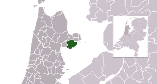
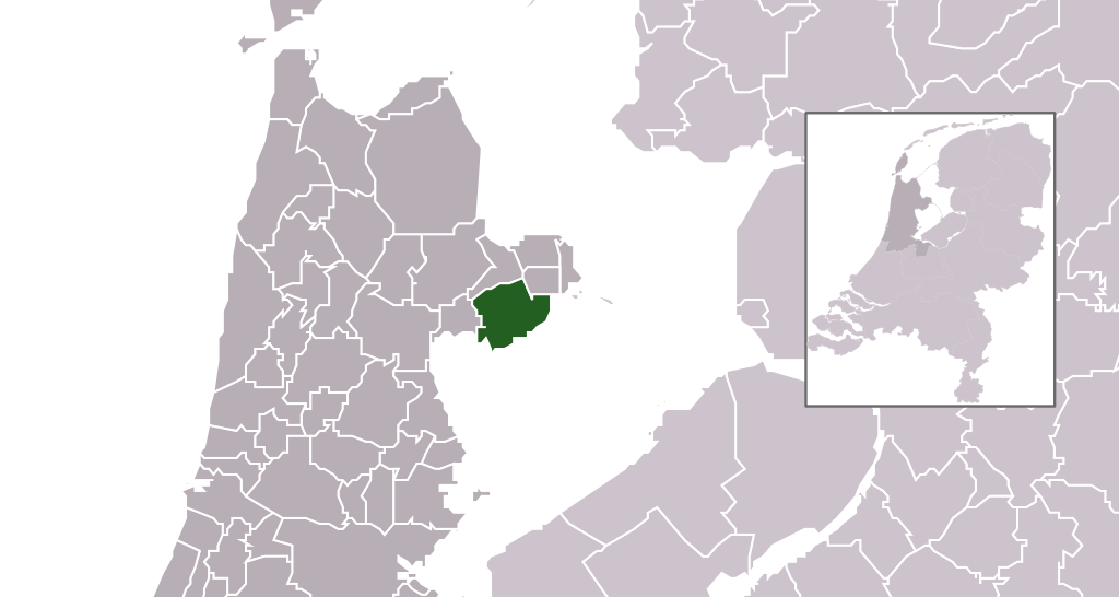
Location maps for the 441 municipalities in the
Netherlands. Boundaries 1/1/2009
293:). Digital geometry files in ESRI format can be downloaded from their website
298:
In particular, boundary data of statistical districts is based on either the
158:
1044:
1009:
999:
941:
1089:
1034:
851:
790:
738:
721:
607:
259:
If you have questions about the archived correspondence, please use the
877:
Click on a date/time to view the file as it appeared at that time.
146:
File name contains "Municipality code" (CBS-code) as specified in:
1109:
249:. The correspondence is available to trusted volunteers as
1074:
227:
and may be used by anyone for any purpose. If you wish to
1084:
1054:
975:
Anexo:Municipios de la provincia de
Holanda Septentrional
89:
83:(SVG file, nominally 300 × 160 pixels, file size: 531 KB)
524:
Add a one-line explanation of what this file represents
371:
294:
935:
193:
178:
955:
875:
745:
Creative
Commons Attribution-ShareAlike 3.0 Unported
702:
Creative Commons Attribution-ShareAlike 3.0 Unported
166:
113:
Commons is a freely licensed media file repository.
351:Bron: © 2005, Centraal Bureau voor de Statistiek
493:https://creativecommons.org/licenses/by-sa/3.0
94:
499:Creative Commons Attribution-Share Alike 3.0
423:
402:
367:
131:
385:
377:
134:Map - NL - Municipality code 0498 (2009).svg
14:
459:– to copy, distribute and transmit the work
46:Size of this PNG preview of this SVG file:
1015:Hollandia önkormányzatai népesség alapján
957:The following other wikis use this file:
306:("CBS/TOPgrenzen"). Data on localities (
273:Find other files from the same ticket:
212:
125:
446:Attribution-Share Alike 3.0 Unported
243:Volunteer Response Team (VRT) member
207:
868:
434:
429:
237:
177:The copyright holder of this file,
143:Automatically generated with script
13:
1135:
1106:Usage on zh-min-nan.wikipedia.org
529:
523:
420:
312:Bevolkingskernen in Nederland 2001
291:Centraal Bureau voor de Statistiek
194:Centraal Bureau voor de Statistiek
179:Centraal Bureau voor de Statistiek
126:
76:
1169:
1149:Nederlandse gemeente Drechterland
1142:
947:Municipalities of the Netherlands
528:
936:
514:
470:Under the following conditions:
441:This file is licensed under the
433:
428:
422:
275:
211:
170:
93:
31:
21:
1045:Lijst van Nederlandse gemeenten
1000:Liste des communes des Pays-Bas
511:
952:
872:
510:
398:) 22:49, 24 January 2009 (UTC)
317:Conditions of use (in Dutch):
183:for any purpose, provided that
26:
1:
1090:Hollanda belediyeleri listesi
36:
1035:Index communium Nederlandiae
932:
781:Wikimedia VRTS ticket number
759:Wikimedia VRTS ticket number
657:Wikimedia VRTS ticket number
576:Wikimedia VRTS ticket number
536:Items portrayed in this file
7:
1157:Database fields = "GM_NAAM"
1132:
1071:Usage on stq.wikipedia.org
310:) are from the publication
10:
1174:
1116:Usage on zh.wikipedia.org
1100:Муніципалітет (Нідерланди)
1096:Usage on uk.wikipedia.org
1081:Usage on tr.wikipedia.org
1061:Usage on ru.wikipedia.org
1051:Usage on pl.wikipedia.org
1041:Usage on nl.wikipedia.org
1031:Usage on la.wikipedia.org
1021:Usage on hy.wikipedia.org
1010:Szerkesztő:B.Zsolt/holland
1006:Usage on hu.wikipedia.org
996:Usage on fr.wikipedia.org
981:Usage on fa.wikipedia.org
971:Usage on es.wikipedia.org
961:Usage on ar.wikipedia.org
484:same or compatible license
414:Attribution ShareAlike 3.0
181:, allows anyone to use it
128:
869:
381:own work , using CBS data
171:
169:
16:
728:attribution only license
698:attribution only license
634:attribution only license
564:attribution only license
513:
450:
304:Wijk- en buurtkaart 2003
300:Wijk- en buurtkaart 2005
252:ticket #2007041210008226
210:
100:This is a file from the
41:
926:
370:
104:. Information from its
985:فهرست شهرستانهای هلند
905:22:49, 24 January 2009
679:Statistics Netherlands
588:Statistics Netherlands
107:description page there
1025:Դրեխտերլանդ (համայնք)
70:2,560 × 1,365 pixels
965:قائمة بلديات هولندا
465:– to adapt the work
52:Other resolutions:
1065:Общины Нидерландов
247:permission archive
245:and stored in our
66:1,280 × 683 pixels
62:1,024 × 546 pixels
1161:
1160:
953:Global file usage
930:
712:copyright license
694:copyright license
627:copyright license
560:copyright license
522:
418:
417:
411:
408:Reusing this file
363:
362:
358:
284:
283:
274:
270:
264:
206:
205:
122:
121:
102:Wikimedia Commons
32:Global file usage
1165:
1143:
917:
879:
819:
814:
797:2007041210008226
763:2007041210008226
681:
676:
672:copyright holder
666:
664:2007041210008226
661:
651:
646:
636:
631:
598:copyright status
584:copyright holder
580:2007041210008226
552:copyright status
520:
506:
503:
500:
497:
494:
486:as the original.
443:Creative Commons
437:
436:
432:
431:
426:
425:
405:
396:
373:
356:
308:bevolkingskernen
286:
285:
279:
272:
265:
258:
239:
230:use this content
219:
215:
214:
208:
201:
174:
173:
167:
135:
129:
118:
97:
96:
90:
84:
73:
58:640 × 341 pixels
54:320 × 171 pixels
48:300 × 160 pixels
1173:
1172:
1168:
1167:
1166:
1164:
1163:
1162:
1131:
951:
938:
931:
923:
915:
871:
870:
867:
866:
865:
864:
863:
862:
861:
860:
858:
848:
847:
846:
844:
829:
828:
827:
826:
825:
824:
823:
822:
821:
820:
817:geographic data
815:
812:
810:applies to part
803:
802:
801:
799:
787:
786:
785:
783:
771:geographic data
767:applies to part
756:
755:
754:
753:
752:
751:
750:
749:
747:
736:
735:
734:
733:
732:
730:
718:
717:
716:
714:
691:
690:
689:
688:
687:
686:
685:
684:
683:
682:
677:
674:
668:
667:
662:
659:
653:
652:
649:geographic data
647:
644:
642:applies to part
638:
637:
632:
629:
620:
619:
618:
616:
604:
603:
602:
600:
572:geographic data
568:applies to part
549:
548:
547:
546:
545:
543:
527:
526:
525:
508:
507:
504:
501:
498:
495:
492:
491:
449:
438:
419:
394:
261:VRT noticeboard
199:
197:
196:
133:
124:
123:
112:
111:
110:is shown below.
86:
82:
75:
74:
51:
12:
11:
5:
1171:
1159:
1158:
1155:
1151:
1150:
1147:
1134:
1130:
1129:
1128:
1127:
1122:
1114:
1113:
1112:
1104:
1103:
1102:
1094:
1093:
1092:
1087:
1079:
1078:
1077:
1069:
1068:
1067:
1059:
1058:
1057:
1049:
1048:
1047:
1039:
1038:
1037:
1029:
1028:
1027:
1019:
1018:
1017:
1012:
1004:
1003:
1002:
994:
993:
992:
987:
979:
978:
977:
969:
968:
967:
954:
950:
949:
944:
934:
929:
928:
925:
921:
918:
912:
907:
902:
898:
897:
894:
891:
888:
885:
882:
874:
859:
856:
854:
853:
852:
850:
849:
845:
840:
838:
837:
836:
835:
833:
808:
807:
806:
805:
804:
800:
795:
793:
792:
791:
789:
788:
784:
779:
777:
776:
775:
774:
772:
768:
764:
760:
748:
743:
741:
740:
739:
737:
731:
726:
724:
723:
722:
720:
719:
715:
710:
708:
707:
706:
705:
703:
699:
695:
670:
669:
655:
654:
640:
639:
625:
624:
623:
622:
621:
617:
612:
610:
609:
608:
606:
605:
601:
596:
594:
593:
592:
591:
589:
585:
581:
577:
573:
569:
565:
561:
557:
553:
544:
539:
537:
534:
533:
532:
531:
519:
518:
515:
512:
490:
489:
488:
487:
477:
468:
467:
466:
460:
453:You are free:
440:
439:
421:
416:
415:
412:
400:
399:
387:
383:
382:
379:
375:
374:
369:
365:
364:
361:
360:
354:
353:
347:
346:
342:
341:
335:
334:
330:
329:
323:
322:
282:
281:
221:
204:
203:
192:
190:
187:
186:
175:
162:
161:
155:
149:
144:
141:
136:
127:
120:
119:
98:
88:
87:
45:
40:
39:
34:
29:
24:
19:
9:
6:
4:
3:
2:
1170:
1156:
1153:
1152:
1148:
1145:
1144:
1141:
1138:
1126:
1123:
1121:
1118:
1117:
1115:
1111:
1108:
1107:
1105:
1101:
1098:
1097:
1095:
1091:
1088:
1086:
1083:
1082:
1080:
1076:
1073:
1072:
1070:
1066:
1063:
1062:
1060:
1056:
1053:
1052:
1050:
1046:
1043:
1042:
1040:
1036:
1033:
1032:
1030:
1026:
1023:
1022:
1020:
1016:
1013:
1011:
1008:
1007:
1005:
1001:
998:
997:
995:
991:
988:
986:
983:
982:
980:
976:
973:
972:
970:
966:
963:
962:
960:
959:
958:
948:
945:
943:
940:
939:
924:
919:
913:
911:
908:
906:
903:
900:
899:
895:
892:
889:
886:
883:
881:
880:
878:
855:
843:
839:
818:
811:
798:
794:
782:
778:
746:
742:
729:
725:
713:
709:
680:
673:
665:
658:
650:
643:
635:
628:
615:
611:
599:
595:
542:
538:
535:
516:
509:
496:CC BY-SA 3.0
485:
481:
478:
475:
472:
471:
469:
464:
461:
458:
455:
454:
452:
451:
447:
444:
427:
413:
409:
404:
401:
397:
391:
388:
384:
380:
376:
366:
359:
352:
349:
348:
344:
343:
340:
337:
336:
332:
331:
328:
325:
324:
320:
319:
318:
315:
313:
309:
305:
301:
295:
292:
288:
287:
280:
278:
271:
269:
266:Ticket link:
262:
256:
254:
253:
248:
244:
240:
232:
231:
226:
223:This work is
222:
220:
209:
202:
195:
191:Attribution:
189:
188:
184:
180:
176:
168:
165:
164:
159:
156:
153:
150:
148:
145:
142:
139:
138:
137:
130:
116:
109:
108:
103:
99:
92:
91:
85:
80:
79:Original file
71:
67:
63:
59:
55:
49:
44:
38:
35:
33:
30:
28:
25:
23:
20:
18:
15:
1139:
1136:
1110:Drechterland
1085:Drechterland
1075:Drechterland
1055:Drechterland
956:
942:Drechterland
876:
873:File history
857:January 2009
479:
473:
462:
456:
372:January 2009
355:
350:
338:
326:
316:
311:
307:
303:
299:
297:
290:
257:
250:
236:
234:
228:
216:
198:
182:
163:
115:You can help
105:
77:
22:File history
1154:Image title
1146:Short title
922:Michiel1972
614:copyrighted
556:copyrighted
480:share alike
474:attribution
390:Michiel1972
200:Attribution
132:Description
933:File usage
914:300 × 160
890:Dimensions
403:Permission
27:File usage
990:درخترلاند
887:Thumbnail
884:Date/Time
842:inception
832:inception
302:, or the
1133:Metadata
916:(531 KB)
517:Captions
463:to remix
457:to share
448:license.
238:reviewed
37:Metadata
901:current
896:Comment
541:depicts
521:English
81:
1120:荷兰市镇列表
386:Author
378:Source
218:
1125:德雷赫特兰
241:by a
893:User
505:true
502:true
395:talk
368:Date
225:free
17:File
813::
675::
660::
645::
630::
314:.
296:.
255:.
68:|
64:|
60:|
56:|
50:.
410:)
406:(
392:(
263:.
160:)
154:)
117:.
72:.
Text is available under the Creative Commons Attribution-ShareAlike License. Additional terms may apply.

.svg)