622:"}},"text\/plain":{"en":{"":"coordinates of the point of view"}}},"{\"value\":{\"latitude\":50.71438,\"longitude\":-1.875,\"altitude\":null,\"precision\":1.0e-5,\"globe\":\"http:\\\/\\\/www.wikidata.org\\\/entity\\\/Q2\"},\"type\":\"globecoordinate\"}":{"text\/html":{"en":{"P1259":"50\u00b042'51.77"N, 1\u00b052'30.00"W"}},"text\/plain":{"en":{"P1259":"50\u00b042'51.77\"N, 1\u00b052'30.00\"W"}}},"{\"value\":{\"entity-type\":\"property\",\"numeric-id\":7787,\"id\":\"P7787\"},\"type\":\"wikibase-entityid\"}":{"text\/html":{"en":{"":"
690:"}},"text\/plain":{"en":{"":"coordinates of depicted place"}}},"{\"value\":{\"latitude\":50.71519,\"longitude\":-1.8803,\"altitude\":null,\"precision\":1.0e-5,\"globe\":\"http:\\\/\\\/www.wikidata.org\\\/entity\\\/Q2\"},\"type\":\"globecoordinate\"}":{"text\/html":{"en":{"P9149":"50\u00b042'54.68"N, 1\u00b052'49.08"W"}},"text\/plain":{"en":{"P9149":"50\u00b042'54.68\"N, 1\u00b052'49.08\"W"}}},"{\"value\":{\"entity-type\":\"property\",\"numeric-id\":7787,\"id\":\"P7787\"},\"type\":\"wikibase-entityid\"}":{"text\/html":{"en":{"":"
796:"}},"text\/plain":{"en":{"":"checksum"}}},"{\"value\":\"5077723f0d4952f37c611b81b175a3d2249c64e4\",\"type\":\"string\"}":{"text\/html":{"en":{"P4092":"5077723f0d4952f37c611b81b175a3d2249c64e4"}},"text\/plain":{"en":{"P4092":"5077723f0d4952f37c611b81b175a3d2249c64e4"}}},"{\"value\":{\"entity-type\":\"property\",\"numeric-id\":459,\"id\":\"P459\"},\"type\":\"wikibase-entityid\"}":{"text\/html":{"en":{"":"
584:"}},"text\/plain":{"en":{"":"inception"}}},"{\"value\":{\"time\":\"+2008-06-09T00:00:00Z\",\"timezone\":0,\"before\":0,\"after\":0,\"precision\":11,\"calendarmodel\":\"http:\\\/\\\/www.wikidata.org\\\/entity\\\/Q1985727\"},\"type\":\"time\"}":{"text\/html":{"en":{"P571":"9 June 2008"}},"text\/plain":{"en":{"P571":"9 June 2008"}}}}": -->
360:
293:
243:
285:
235:
792:
257:
328:
366:
371:
67:
800:"}},"text\/plain":{"en":{"":"determination method"}}},"{\"value\":{\"entity-type\":\"item\",\"numeric-id\":13414952,\"id\":\"Q13414952\"},\"type\":\"wikibase-entityid\"}":{"text\/html":{"en":{"P459":"
758:"}},"text\/plain":{"en":{"":"media type"}}},"{\"value\":\"image\\\/jpeg\",\"type\":\"string\"}":{"text\/html":{"en":{"P1163":"image\/jpeg"}},"text\/plain":{"en":{"P1163":"image\/jpeg"}}}}": -->
540:"}},"text\/plain":{"en":{"":"copyright license"}}},"{\"value\":{\"entity-type\":\"item\",\"numeric-id\":19068220,\"id\":\"Q19068220\"},\"type\":\"wikibase-entityid\"}":{"text\/html":{"en":{"P275":"
496:"}},"text\/plain":{"en":{"":"copyright status"}}},"{\"value\":{\"entity-type\":\"item\",\"numeric-id\":50423863,\"id\":\"Q50423863\"},\"type\":\"wikibase-entityid\"}":{"text\/html":{"en":{"P6216":"
863:"}},"text\/plain":{"en":{"":"data size"}}},"{\"value\":{\"amount\":\"+102965\",\"unit\":\"http:\\\/\\\/www.wikidata.org\\\/entity\\\/Q8799\"},\"type\":\"quantity\"}":{"text\/html":{"en":{"P3575":"102,965
908:"}},"text\/plain":{"en":{"":"height"}}},"{\"value\":{\"amount\":\"+424\",\"unit\":\"http:\\\/\\\/www.wikidata.org\\\/entity\\\/Q355198\"},\"type\":\"quantity\"}":{"text\/html":{"en":{"P2048":"424
694:"}},"text\/plain":{"en":{"":"heading"}}},"{\"value\":{\"amount\":\"+292\",\"unit\":\"http:\\\/\\\/www.wikidata.org\\\/entity\\\/Q28390\"},\"type\":\"quantity\"}":{"text\/html":{"en":{"P7787":"292
626:"}},"text\/plain":{"en":{"":"heading"}}},"{\"value\":{\"amount\":\"+292\",\"unit\":\"http:\\\/\\\/www.wikidata.org\\\/entity\\\/Q28390\"},\"type\":\"quantity\"}":{"text\/html":{"en":{"P7787":"292
953:"}},"text\/plain":{"en":{"":"width"}}},"{\"value\":{\"amount\":\"+640\",\"unit\":\"http:\\\/\\\/www.wikidata.org\\\/entity\\\/Q355198\"},\"type\":\"quantity\"}":{"text\/html":{"en":{"P2049":"640
949:
276:
38:
226:
418:– You must give appropriate credit, provide a link to the license, and indicate if changes were made. You may do so in any reasonable manner, but not in any way that suggests the licensor endorses you or your use.
290:
240:
801:
541:
497:
950:
905:
860:
793:
755:
691:
687:
623:
619:
493:
797:
581:
537:
1053:==Summary== {{Information| |Description = {{en|The West Cliff Railway at Bournemouth, Dorset, England. For more information see the Knowledge article ''
78:
46:
544:"}},"text\/plain":{"en":{"P275":"Creative Commons Attribution-ShareAlike 2.0 Generic"}}}}": -->
163:
845:
567:
523:
300:
250:
335:
1082:
This file contains additional information, probably added from the digital camera or scanner used to create or digitize it.
425:
964:
919:
874:
811:
765:
732:
705:
664:
637:
507:
838:
591:
551:
482:
381:
804:"}},"text\/plain":{"en":{"P459":"saquina cha\u00faque"}}}}": -->
1085:
If the file has been modified from its original state, some details may not fully reflect the modified file.
424:– If you remix, transform, or build upon the material, you must distribute your contributions under the
342:
on the
Geograph website for the photographer's contact details. The copyright on this image is owned by
121:
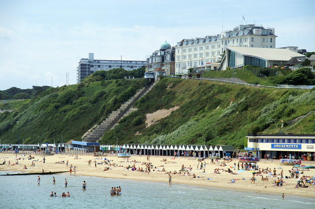
The West Cliff
Railway at Bournemouth, Dorset, England. For more information see the Knowledge article
1035:
1030:
867:"}},"text\/plain":{"en":{"P3575":"102,965 byte"}}}}": -->
37:
500:"}},"text\/plain":{"en":{"P6216":"copyrighted"}}}}": -->
1067:
The following pages on the
English Knowledge use this file (pages on other projects are not listed):
698:"}},"text\/plain":{"en":{"P7787":"292 degree"}}}}": -->
630:"}},"text\/plain":{"en":{"P7787":"292 degree"}}}}": -->
957:"}},"text\/plain":{"en":{"P2049":"640 pixel"}}}}": -->
912:"}},"text\/plain":{"en":{"P2048":"424 pixel"}}}}": -->
86:
195:
123:
378:
179:
8:
322:
1071:
1054:
306:
256:
1046:
347:
73:
472:
974:
929:
884:
821:
775:
715:
647:
601:
561:
517:
327:
339:
1057:'' .}} |Source = www.geograph.org.uk. |Date = 9 June, 200
1003:
Click on a date/time to view the file as it appeared at that time.
292:
242:
170:
Published under
Creative Commons Attribution-Sharealike 2.0.
277:
50° 42′ 55″ N, 1° 52′ 49″ W
227:
50° 42′ 52″ N, 1° 52′ 30″ W
136:
61:
466:
Add a one-line explanation of what this file represents
1065:
1001:
85:
Commons is a freely licensed media file repository.
568:
Creative
Commons Attribution-ShareAlike 2.0 Generic
542:
Creative
Commons Attribution-ShareAlike 2.0 Generic
51:(640 × 424 pixels, file size: 101 KB, MIME type:
435:https://creativecommons.org/licenses/by-sa/2.0
66:
441:Creative Commons Attribution-Share Alike 2.0
359:
158:
132:
108:
150:
142:
14:
954:
909:
864:
695:
627:
401:– to copy, distribute and transmit the work
827:5077723f0d4952f37c611b81b175a3d2249c64e4
299:View this and other nearby images on:
249:View this and other nearby images on:
202:
97:
346:and is licensed for reuse under the
267:
217:
111:Bournemouth West Cliff Railway 2.jpg
47:Bournemouth_West_Cliff_Railway_2.jpg
994:
382:Attribution-Share Alike 2.0 Generic
370:
365:
350:Attribution-ShareAlike 2.0 license.
13:
1080:
471:
465:
356:
333:
115:
98:
44:
1106:
1087:
470:
1066:
638:coordinates of the point of view
620:coordinates of the point of view
456:
412:Under the following conditions:
377:This file is licensed under the
369:
364:
358:
326:
305:
291:
283:
255:
241:
233:
65:
21:
453:
116:
41:No higher resolution available.
998:
452:
334:This image was taken from the
26:
1:
706:coordinates of depicted place
688:coordinates of depicted place
31:
1062:
478:Items portrayed in this file
318:
282:
232:
7:
1077:
721:50°42'54.68"N, 1°52'49.08"W
653:50°42'51.77"N, 1°52'30.00"W
10:
1111:
426:same or compatible license
105:
100:
995:
208:Pierre Terre /
189:Pierre Terre /
16:
455:
392:
72:This is a file from the
36:
1052:
210:Bournemouth -West Cliff
191:Bournemouth -West Cliff
180:required by the license
135:
76:. Information from its
340:this photograph's page
311:50.715190; -1.880300
261:50.714380; -1.875000
79:description page there
839:determination method
802:saquina cha\u00faque
798:determination method
146:www.geograph.org.uk.
407:– to adapt the work
1072:West Cliff Railway
1055:West Cliff Railway
1031:16:44, 15 May 2009
124:West Cliff Railway
1098:
1097:
1060:
956:
911:
866:
697:
629:
552:copyright license
538:copyright license
464:
355:
354:
338:collection. See
316:
315:
266:
265:
215:
214:
183:
167:
164:Reusing this file
94:
93:
74:Wikimedia Commons
1102:
1088:
1043:
1005:
983:
938:
893:
848:
843:
743:
742:
737:
675:
674:
669:
508:copyright status
494:copyright status
462:
448:
445:
442:
439:
436:
428:as the original.
390:
379:Creative Commons
373:
372:
368:
367:
362:
361:
348:Creative Commons
336:Geograph project
330:
323:
312:
309:
295:
294:
288:
287:
286:
280:
279:
268:
262:
259:
245:
244:
238:
237:
236:
230:
229:
218:
177:
161:
138:
120:
112:
106:
90:
69:
68:
62:
56:
54:
1110:
1109:
1105:
1104:
1103:
1101:
1100:
1099:
1076:
1068:
1061:
1049:
1041:
997:
996:
993:
992:
991:
990:
989:
988:
987:
986:
984:
981:
971:
970:
969:
967:
948:
947:
946:
945:
944:
943:
942:
941:
939:
936:
926:
925:
924:
922:
903:
902:
901:
900:
899:
898:
897:
896:
894:
891:
881:
880:
879:
877:
858:
857:
856:
855:
854:
853:
852:
851:
850:
849:
846:saquina chaúque
844:
841:
832:
831:
830:
828:
818:
817:
816:
814:
791:
790:
789:
788:
787:
786:
785:
784:
782:
772:
771:
770:
768:
753:
752:
751:
750:
749:
748:
747:
746:
745:
744:
740:
738:
735:
726:
725:
724:
722:
712:
711:
710:
708:
685:
684:
683:
682:
681:
680:
679:
678:
677:
676:
672:
670:
667:
658:
657:
656:
654:
644:
643:
642:
640:
617:
616:
615:
614:
613:
612:
611:
610:
608:
598:
597:
596:
594:
579:
578:
577:
576:
575:
574:
573:
572:
570:
558:
557:
556:
554:
535:
534:
533:
532:
531:
530:
529:
528:
526:
514:
513:
512:
510:
491:
490:
489:
488:
487:
485:
469:
468:
467:
450:
449:
446:
443:
440:
437:
434:
433:
391:
388:
385:
374:
351:
321:
310:
284:
275:
274:
271:Object location
260:
234:
225:
224:
221:Camera location
216:
205:
198:
186:
128:
110:
103:
96:
95:
84:
83:
82:is shown below.
58:
52:
50:
43:
42:
12:
11:
5:
1108:
1096:
1095:
1092:
1079:
1075:
1074:
1064:
1059:
1058:
1051:
1047:
1044:
1038:
1033:
1028:
1024:
1023:
1020:
1017:
1014:
1011:
1008:
1000:
985:
979:
977:
976:
975:
973:
972:
968:
963:
961:
960:
959:
958:
952:
940:
934:
932:
931:
930:
928:
927:
923:
918:
916:
915:
914:
913:
907:
895:
889:
887:
886:
885:
883:
882:
878:
873:
871:
870:
869:
868:
862:
837:
836:
835:
834:
833:
829:
826:
824:
823:
822:
820:
819:
815:
810:
808:
807:
806:
805:
803:
799:
795:
783:
780:
778:
777:
776:
774:
773:
769:
764:
762:
761:
760:
759:
757:
731:
730:
729:
728:
727:
723:
720:
718:
717:
716:
714:
713:
709:
704:
702:
701:
700:
699:
693:
689:
663:
662:
661:
660:
659:
655:
652:
650:
649:
648:
646:
645:
641:
636:
634:
633:
632:
631:
625:
621:
609:
606:
604:
603:
602:
600:
599:
595:
590:
588:
587:
586:
585:
583:
571:
566:
564:
563:
562:
560:
559:
555:
550:
548:
547:
546:
545:
543:
539:
527:
522:
520:
519:
518:
516:
515:
511:
506:
504:
503:
502:
501:
499:
495:
486:
481:
479:
476:
475:
474:
473:
461:
460:
457:
454:
432:
431:
430:
429:
419:
410:
409:
408:
402:
395:You are free:
386:
376:
375:
357:
353:
352:
331:
320:
317:
314:
313:
303:
297:
272:
264:
263:
253:
247:
222:
213:
212:
206:
203:
200:
199:
194:
187:
184:
172:
171:
168:
156:
155:
152:
148:
147:
144:
140:
139:
134:
130:
129:
113:
104:
102:
99:
92:
91:
70:
60:
59:
40:
35:
34:
29:
24:
19:
9:
6:
4:
3:
2:
1107:
1093:
1090:
1089:
1086:
1083:
1073:
1070:
1069:
1056:
1050:
1045:
1039:
1037:
1034:
1032:
1029:
1026:
1025:
1021:
1018:
1015:
1012:
1009:
1007:
1006:
1004:
978:
966:
962:
933:
921:
917:
888:
876:
872:
847:
840:
825:
813:
809:
779:
767:
763:
734:
719:
707:
703:
666:
651:
639:
635:
605:
593:
589:
569:
565:
553:
549:
525:
521:
509:
505:
484:
480:
477:
458:
451:
438:CC BY-SA 2.0
427:
423:
420:
417:
414:
413:
411:
406:
403:
400:
397:
396:
394:
393:
387:Attribution:
383:
380:
363:
349:
345:
341:
337:
332:
329:
325:
324:
308:
304:
302:
301:OpenStreetMap
298:
296:
278:
273:
270:
269:
258:
254:
252:
251:OpenStreetMap
248:
246:
228:
223:
220:
219:
211:
207:
201:
197:
193: /
192:
188:
181:
176:
174:
173:
169:
165:
160:
157:
154:Pierre Terre.
153:
149:
145:
141:
131:
126:
125:
119:
114:
107:
88:
81:
80:
75:
71:
64:
63:
57:
48:
39:
33:
30:
28:
25:
23:
20:
18:
15:
1084:
1081:
1048:Chris j wood
1002:
999:File history
421:
415:
404:
398:
389:Pierre Terre
344:Pierre Terre
343:
281:
231:
209:
196:CC BY-SA 2.0
190:
122:
117:
87:You can help
77:
45:
22:File history
607:9 June 2008
524:copyrighted
498:copyrighted
422:share alike
416:attribution
175:Attribution
137:9 June 2008
109:Description
1091:_error
1063:File usage
1040:640 × 424
1016:Dimensions
781:image/jpeg
766:media type
756:media type
159:Permission
53:image/jpeg
27:File usage
1013:Thumbnail
1010:Date/Time
875:data size
861:data size
592:inception
582:inception
319:Licensing
204:InfoField
185:InfoField
118:English:
1078:Metadata
1042:(101 KB)
890:102,965
812:checksum
794:checksum
459:Captions
405:to remix
399:to share
384:license.
32:Metadata
1027:current
1022:Comment
733:heading
692:heading
665:heading
624:heading
483:depicts
463:English
101:Summary
49:
920:height
906:height
741:degree
696:degree
673:degree
628:degree
289:
239:
151:Author
143:Source
982:pixel
965:width
955:pixel
951:width
937:pixel
910:pixel
1019:User
980:640
935:424
892:byte
865:byte
739:292
671:292
447:true
444:true
133:Date
17:File
842::
736::
668::
1094:0
182:)
178:(
166:)
162:(
127:.
89:.
55:)
_heading:292.00&language=en)
_heading:292.00&language=en)
