38:
797:"}},"text\/plain":{"en":{"":"checksum"}}},"{\"value\":\"0f21ac532922442906aa7ea8d1e15921ee4dad7a\",\"type\":\"string\"}":{"text\/html":{"en":{"P4092":"0f21ac532922442906aa7ea8d1e15921ee4dad7a"}},"text\/plain":{"en":{"P4092":"0f21ac532922442906aa7ea8d1e15921ee4dad7a"}}},"{\"value\":{\"entity-type\":\"property\",\"numeric-id\":459,\"id\":\"P459\"},\"type\":\"wikibase-entityid\"}":{"text\/html":{"en":{"":"
365:
677:"}},"text\/plain":{"en":{"":"inception"}}},"{\"value\":{\"time\":\"+2012-11-30T00:00:00Z\",\"timezone\":0,\"before\":0,\"after\":0,\"precision\":11,\"calendarmodel\":\"http:\\\/\\\/www.wikidata.org\\\/entity\\\/Q1985727\"},\"type\":\"time\"}":{"text\/html":{"en":{"P571":"30 November 2012"}},"text\/plain":{"en":{"P571":"30 November 2012"}}}}": -->
455:
793:
279:
94:
475:"}},"text\/plain":{"en":{"P2093":"Carport","P4174":"Carport"}}},"{\"value\":{\"entity-type\":\"property\",\"numeric-id\":4174,\"id\":\"P4174\"},\"type\":\"wikibase-entityid\"}":{"text\/html":{"en":{"":"
463:"}},"text\/plain":{"en":{"":"object of statement has role"}}},"{\"value\":{\"entity-type\":\"item\",\"numeric-id\":33231,\"id\":\"Q33231\"},\"type\":\"wikibase-entityid\"}":{"text\/html":{"en":{"P3831":"
801:"}},"text\/plain":{"en":{"":"determination method"}}},"{\"value\":{\"entity-type\":\"item\",\"numeric-id\":13414952,\"id\":\"Q13414952\"},\"type\":\"wikibase-entityid\"}":{"text\/html":{"en":{"P459":"
759:"}},"text\/plain":{"en":{"":"media type"}}},"{\"value\":\"image\\\/jpeg\",\"type\":\"string\"}":{"text\/html":{"en":{"P1163":"image\/jpeg"}},"text\/plain":{"en":{"P1163":"image\/jpeg"}}}}": -->
864:"}},"text\/plain":{"en":{"":"data size"}}},"{\"value\":{\"amount\":\"+1520233\",\"unit\":\"http:\\\/\\\/www.wikidata.org\\\/entity\\\/Q8799\"},\"type\":\"quantity\"}":{"text\/html":{"en":{"P3575":"1,520,233
633:"}},"text\/plain":{"en":{"":"copyright license"}}},"{\"value\":{\"entity-type\":\"item\",\"numeric-id\":14946043,\"id\":\"Q14946043\"},\"type\":\"wikibase-entityid\"}":{"text\/html":{"en":{"P275":"
589:"}},"text\/plain":{"en":{"":"copyright status"}}},"{\"value\":{\"entity-type\":\"item\",\"numeric-id\":50423863,\"id\":\"Q50423863\"},\"type\":\"wikibase-entityid\"}":{"text\/html":{"en":{"P6216":"
715:"}},"text\/plain":{"en":{"":"source of file"}}},"{\"value\":{\"entity-type\":\"item\",\"numeric-id\":66458942,\"id\":\"Q66458942\"},\"type\":\"wikibase-entityid\"}":{"text\/html":{"en":{"P7482":"
1037:
479:"}},"text\/plain":{"en":{"":"Wikimedia username"}}},"{\"value\":{\"entity-type\":\"property\",\"numeric-id\":2699,\"id\":\"P2699\"},\"type\":\"wikibase-entityid\"}":{"text\/html":{"en":{"":"
909:"}},"text\/plain":{"en":{"":"height"}}},"{\"value\":{\"amount\":\"+2402\",\"unit\":\"http:\\\/\\\/www.wikidata.org\\\/entity\\\/Q355198\"},\"type\":\"quantity\"}":{"text\/html":{"en":{"P2048":"2,402
467:"}},"text\/plain":{"en":{"P3831":"photographer"}}},"{\"value\":{\"entity-type\":\"property\",\"numeric-id\":2093,\"id\":\"P2093\"},\"type\":\"wikibase-entityid\"}":{"text\/html":{"en":{"":"
954:"}},"text\/plain":{"en":{"":"width"}}},"{\"value\":{\"amount\":\"+1680\",\"unit\":\"http:\\\/\\\/www.wikidata.org\\\/entity\\\/Q355198\"},\"type\":\"quantity\"}":{"text\/html":{"en":{"P2049":"1,680
412:"}},"text\/plain":{"en":{"":"depicts"}}},"{\"value\":{\"entity-type\":\"item\",\"numeric-id\":2928585,\"id\":\"Q2928585\"},\"type\":\"wikibase-entityid\"}":{"text\/html":{"en":{"P180":"
459:"}},"text\/plain":{"en":{"":"creator"}}},"{\"value\":{\"entity-type\":\"property\",\"numeric-id\":3831,\"id\":\"P3831\"},\"type\":\"wikibase-entityid\"}":{"text\/html":{"en":{"":"
950:
471:"}},"text\/plain":{"en":{"":"author name string"}}},"{\"value\":\"Carport\",\"type\":\"string\"}":{"text\/html":{"en":{"P2093":"Carport","P4174":"
483:"}},"text\/plain":{"en":{"":"URL"}}},"{\"value\":\"http:\\\/\\\/commons.wikimedia.org\\\/wiki\\\/User:Carport\",\"type\":\"string\"}":{"text\/html":{"en":{"P2699":"
1620:
1615:
1582:
1073:
320:– You must give appropriate credit, provide a link to the license, and indicate if changes were made. You may do so in any reasonable manner, but not in any way that suggests the licensor endorses you or your use.
1085:
1874:
1280:
472:
1410:
1165:
60:
56:
52:
48:
42:
105:
73:
1530:
1315:
1170:
1265:
802:
716:
634:
590:
1545:
413:
484:
1400:
1300:
464:
951:
906:
861:
794:
756:
712:
586:
480:
476:
468:
460:
798:
674:
630:
456:
409:
1500:
1125:
226:
1350:
1295:
1195:
1575:
1425:
1220:
1455:
1047:
1465:
1475:
1230:
1190:
1160:
637:"}},"text\/plain":{"en":{"P275":"Creative Commons Attribution-ShareAlike 3.0 Unported"}}}}": -->
487:"}},"text\/plain":{"en":{"P2699":"http:\/\/commons.wikimedia.org\/wiki\/User:Carport"}}}}": -->
1180:
1145:
1510:
1120:
1395:
1225:
1635:
364:
1450:
1175:
257:
1275:
1135:
1525:
1495:
1490:
1380:
1340:
1460:
1210:
846:
742:
660:
616:
1565:
1540:
1470:
442:
1535:
1435:
1335:
1215:
327:
1036:
1031:
528:
64:
37:
1550:
1130:
965:
920:
875:
812:
766:
726:
600:
564:
549:
536:
521:
1205:
719:"}},"text\/plain":{"en":{"P7482":"original creation by uploader"}}}}": -->
839:
684:
644:
494:
426:
1355:
1445:
1375:
1625:
1560:
1115:
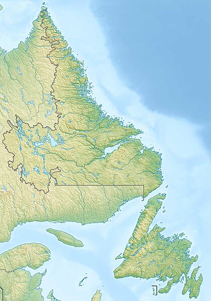
1062:}} Quadratische Plattkarte, N-S-Streckung 160 %. Geographische Begrenzung der Karte: * N: 60.8° N * S: 46.5°...
556:
289:
1140:
1072:
More than 100 pages use this file. The following list shows the first 100 pages that use this file only. A
1055:
144:
868:"}},"text\/plain":{"en":{"P3575":"1,520,233 byte"}}}}": -->
326:– If you remix, transform, or build upon the material, you must distribute your contributions under the
176:
1325:
416:"}},"text\/plain":{"en":{"P180":"Burnt Islands"}}}}": -->
1650:
1370:
958:"}},"text\/plain":{"en":{"P2049":"1,680 pixel"}}}}": -->
913:"}},"text\/plain":{"en":{"P2048":"2,402 pixel"}}}}": -->
593:"}},"text\/plain":{"en":{"P6216":"copyrighted"}}}}": -->
1710:
1090:
1700:
113:
1330:
805:"}},"text\/plain":{"en":{"P459":"SHA-1"}}}}": -->
1600:
571:
1480:
286:
8:
1505:
1240:
1570:
1405:
1245:
230:
153:
Quadratische
Plattkarte, N-S-Streckung 160 %. Geographische Begrenzung der Karte:
1785:
1555:
1290:
185:
Equirectangular projection, N/S stretching 160 %. Geographic limits of the map:
100:
1430:
1360:
1310:
1110:
1105:
1725:
1415:
1345:
1200:
1840:
1830:
1605:
1515:
1390:
1365:
1255:
1155:
1095:
1835:
1320:
1305:
1281:
Jackson's Cove-Langdon's Cove-Silverdale, Newfoundland and
Labrador
1250:
1100:
246:
1860:
1855:
1845:
1825:
1385:
1285:
1150:
1865:
1800:
975:
930:
885:
822:
776:
736:
694:
654:
610:
504:
436:
1780:
1670:
1520:
1440:
1420:
1411:
Northwest Brook-Ivany's Cove-Queens Cove, Newfoundland and
Labrador
1166:
Burnt Cove, St. Michael's, Bauline South, Newfoundland and
Labrador
1815:
1485:
1185:
1080:
1665:
1740:
1531:
St. Joseph's Cove-St. Veronica's, Newfoundland and
Labrador
1260:
1059:
148:
1820:
1720:
1004:
Click on a date/time to view the file as it appeared at that time.
1795:
180:
1690:
1270:
1235:
1680:
1675:
1266:
Hickman's
Harbour-Robinson Bight, Newfoundland and Labrador
1685:
1316:
Little
Harbour (East), Placentia Bay, Newfoundland and Labrador
1171:
Burnt Point-Gull Island-Northern Bay, Newfoundland and
Labrador
1086:
Akami−Uapishkᵘ−KakKasuak−Mealy
Mountains National Park Reserve
1054:{{Information |Description= {{de|Physische Positionskarte von
1546:
Summerville-Princeton-Southern Bay, Newfoundland and
Labrador
1401:
North Harbour, St. Mary's Bay, Newfoundland and Labrador
1301:
L'Anse aux Meadows to Quirpon, Newfoundland and Labrador
1805:
1730:
1765:
1760:
1745:
1715:
1790:
1770:
1750:
1775:
208:
88:
1850:
1705:
1651:
Skabelon:Kortpositioner Canada Newfoundland and Labrador
1501:
Ship Cove, Northern Peninsula, Newfoundland and Labrador
1126:
Bear Cove, Northern Peninsula, Newfoundland and Labrador
133:
Canada Newfoundland and Labrador relief location map.jpg
1810:
1755:
1660:
394:
Add a one-line explanation of what this file represents
1711:
Vorlage:Positionskarte Kanada Neufundland und Labrador
1695:
1426:
O'Regan's Central, Newfoundland and Labrador
227:
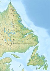
File:Canada Newfoundland and Labrador location map.svg
78:(1,680 × 2,402 pixels, file size: 1.45 MB, MIME type:
1735:
1701:
Knowledge:Kartenwerkstatt/Positionskarten/Nordamerika
1351:
Millville to Cape Anguille, Newfoundland and Labrador
1070:
1641:Кеп:Меттиган карта Канада Ньюфаундленд а, Лабрадор а
1591:
1296:
Knights Cove - Stock Cove, Newfoundland and Labrador
1196:
Champneys-English Harbour, Newfoundland and Labrador
1002:
661:
Creative Commons Attribution-ShareAlike 3.0 Unported
635:
Creative Commons Attribution-ShareAlike 3.0 Unported
112:
Commons is a freely licensed media file repository.
1576:
User:Michael!/Project:Location map templates/Canada
1221:Forest Field-New Bridge, Newfoundland and Labrador
485:http:\/\/commons.wikimedia.org\/wiki\/User:Carport
1456:Pidgeon Cove-St. Barbe, Newfoundland and Labrador
1601:Taman Nasional Cagar Palemahan Pagunungan Mealy
1466:Pollard's Point, Newfoundland and Labrador
337:https://creativecommons.org/licenses/by-sa/3.0
93:
1511:Smith's Sound, Newfoundland and Labrador
1476:Random Island West, Newfoundland and Labrador
1231:Fox Roost-Margaree, Newfoundland and Labrador
1191:Castor River South, Newfoundland and Labrador
1161:Burnside-St. Chads, Newfoundland and Labrador
1121:Bay d'Espoir Hydroelectric Power Station
343:Creative Commons Attribution-Share Alike 3.0
267:
252:
204:
130:
1181:Cape Freels North, Newfoundland and Labrador
1146:Black Duck River (Newfoundland and Labrador)
356:
242:
214:
14:
1396:Norris Arm North, Newfoundland and Labrador
1226:Forresters Point, Newfoundland and Labrador
955:
910:
865:
303:– to copy, distribute and transmit the work
1526:St. John's, Newfoundland and Labrador
1451:Piccadilly Head, Newfoundland and Labrador
1176:Campbells Creek, Newfoundland and Labrador
1786:Vorlage:Positionskarte Kanada Neufundland
1593:The following other wikis use this file:
1276:Humber Village, Newfoundland and Labrador
1136:Bellevue Beach, Newfoundland and Labrador
572:http://commons.wikimedia.org/User:Carport
1496:Sheppardville, Newfoundland and Labrador
1491:Sandbanks Provincial Park (Newfoundland)
1381:Nameless Cove, Newfoundland and Labrador
1341:Menihek Hydroelectric Generating Station
828:0f21ac532922442906aa7ea8d1e15921ee4dad7a
1621:Шаблон:ПК Канада Нюфаундленд и Лабрадор
1461:Pleasantview, Newfoundland and Labrador
1211:Diamond Cove, Newfoundland and Labrador
402:Burnt Islands (Terre-Neuve-et-Labrador)
1566:Twin Falls (Newfoundland and Labrador)
1541:St. Juliens, Newfoundland and Labrador
1471:Pynns Brook, Newfoundland and Labrador
1726:Belle Isle (Neufundland und Labrador)
124:
1616:Сейнт Джонс (Нюфаундленд и Лабрадор)
1536:St. Judes, Newfoundland and Labrador
1436:Outline of Newfoundland and Labrador
1336:Marysvale, Newfoundland and Labrador
1216:Fairhaven, Newfoundland and Labrador
290:Attribution-Share Alike 3.0 Unported
1841:Hare Bay Islands Ecological Reserve
1831:Baccalieu Island Ecological Reserve
1551:Thornlea, Newfoundland and Labrador
1131:Bellevue, Newfoundland and Labrador
995:
278:
273:
13:
1206:Churchill Falls Generating Station
407:
401:
393:
264:
169:
137:
125:
71:
1886:
1836:Gannet Islands Ecological Reserve
1606:Taman Nasional Pagunungan Torngat
1356:Milton, Newfoundland and Labrador
406:
1446:Petty Harbour Generating Station
1376:Muskrat Falls Generating Station
384:
363:
314:Under the following conditions:
285:This file is licensed under the
277:
272:
266:
92:
31:
21:
1561:Torngat Mountains National Park
381:
170:
1861:Watts Point Ecological Reserve
1856:Table Point Ecological Reserve
1846:Funk Island Ecological Reserve
1826:Witless Bay Ecological Reserve
1588:
1141:Bishop's Mitre (Labrador)
1116:Bald Head River (Newfoundland)
999:
380:
138:
26:
1:
1866:West Brook Ecological Reserve
1801:Wasserkraftwerk Menihek Lakes
743:original creation by uploader
717:original creation by uploader
370:Equivalent administrative map
143:Physische Positionskarte von
1781:Bay of Islands (Neufundland)
1671:Blow Me Down Provincial Park
1067:
522:object of statement has role
461:object of statement has role
422:Items portrayed in this file
7:
1597:Usage on ban.wikipedia.org
1326:Long Pond (St. John's)
236:STRM-30 data for the relief
10:
1891:
1816:The Arches Provincial Park
1657:Usage on de.wikipedia.org
1647:Usage on da.wikipedia.org
1632:Usage on ce.wikipedia.org
1612:Usage on bg.wikipedia.org
328:same or compatible license
127:
1666:Bell Island (Neufundland)
1371:Mundy Pond (Newfoundland)
996:
219:
177:Newfoundland and Labrador
175:Physical location map of
16:
1741:Great Northern Peninsula
1331:Mary Brown's Centre
1091:Annieopsquotch Mountains
1056:Neufundland und Labrador
383:
294:
145:Neufundland und Labrador
99:This is a file from the
36:
1821:Dungeon Provincial Park
1053:
1032:18:28, 11 December 2012
207:
103:. Information from its
106:description page there
41:Size of this preview:
1796:Ossokmanuan Reservoir
1691:Long Range Mountains
1481:Richard E. Ellsworth
1241:Green's Harbour
840:determination method
799:determination method
65:1,680 × 2,402 pixels
1681:Smallwood Reservoir
1676:Twillingate Islands
1506:Smallwood Reservoir
309:– to adapt the work
47:Other resolutions:
1686:Avalon (Halbinsel)
1571:Western Brook Pond
1406:Northern Bay Sands
1246:Green Island Brook
550:Wikimedia username
537:author name string
477:Wikimedia username
469:author name string
61:716 × 1,024 pixels
1875:more global usage
1721:Belle-Isle-Straße
1589:Global file usage
1556:Torngat Mountains
1291:Kauerdluksoak Bay
1065:
957:
912:
867:
645:copyright license
631:copyright license
400:
392:
377:
376:
261:
258:Reusing this file
121:
120:
101:Wikimedia Commons
32:Global file usage
1882:
1636:Каботан хидоькъе
1431:Ossokmanuan Lake
1361:Mistastin crater
1311:Leila Wynne Lake
1111:Baccalieu Island
1106:Avayalik Islands
1044:
1006:
984:
939:
894:
849:
844:
700:30 November 2012
601:copyright status
587:copyright status
574:
569:
559:
554:
544:
541:
531:
526:
398:
390:
367:
350:
347:
344:
341:
338:
330:as the original.
287:Creative Commons
281:
280:
276:
275:
270:
269:
255:
221:
210:
209:30 November 2012
174:
142:
134:
128:
117:
96:
95:
89:
83:
81:
68:
57:537 × 768 pixels
53:336 × 480 pixels
49:168 × 240 pixels
43:419 × 599 pixels
1890:
1889:
1885:
1884:
1883:
1881:
1880:
1879:
1806:St. Lewis Inlet
1731:Killiniq Island
1587:
1416:NunatuKavummiut
1346:Michikamau Lake
1201:Churchill Falls
1066:
1050:
1042:
998:
997:
994:
993:
992:
991:
990:
989:
988:
987:
985:
982:
972:
971:
970:
968:
949:
948:
947:
946:
945:
944:
943:
942:
940:
937:
927:
926:
925:
923:
904:
903:
902:
901:
900:
899:
898:
897:
895:
892:
882:
881:
880:
878:
859:
858:
857:
856:
855:
854:
853:
852:
851:
850:
845:
842:
833:
832:
831:
829:
819:
818:
817:
815:
792:
791:
790:
789:
788:
787:
786:
785:
783:
773:
772:
771:
769:
754:
753:
752:
751:
750:
749:
748:
747:
745:
733:
732:
731:
729:
710:
709:
708:
707:
706:
705:
704:
703:
701:
691:
690:
689:
687:
672:
671:
670:
669:
668:
667:
666:
665:
663:
651:
650:
649:
647:
628:
627:
626:
625:
624:
623:
622:
621:
619:
607:
606:
605:
603:
584:
583:
582:
581:
580:
579:
578:
577:
576:
575:
570:
567:
561:
560:
555:
552:
546:
545:
542:
539:
533:
532:
527:
524:
515:
514:
513:
511:
501:
500:
499:
497:
454:
453:
452:
451:
450:
449:
448:
447:
445:
433:
432:
431:
429:
405:
404:
403:
396:
395:
378:
371:
368:
352:
351:
348:
345:
342:
339:
336:
335:
293:
282:
183:
151:
132:
123:
122:
111:
110:
109:is shown below.
85:
79:
77:
70:
69:
46:
12:
11:
5:
1888:
1877:of this file.
1871:
1870:
1869:
1868:
1863:
1858:
1853:
1848:
1843:
1838:
1833:
1828:
1823:
1818:
1813:
1808:
1803:
1798:
1793:
1788:
1783:
1778:
1773:
1768:
1766:Hamilton Inlet
1763:
1761:Ashuanipi Lake
1758:
1753:
1748:
1746:Mistastin Lake
1743:
1738:
1733:
1728:
1723:
1718:
1716:Landsat Island
1713:
1708:
1703:
1698:
1693:
1688:
1683:
1678:
1673:
1668:
1663:
1655:
1654:
1653:
1645:
1644:
1643:
1638:
1630:
1629:
1628:
1626:Кабот (проток)
1623:
1618:
1610:
1609:
1608:
1603:
1590:
1585:to this file.
1579:
1578:
1573:
1568:
1563:
1558:
1553:
1548:
1543:
1538:
1533:
1528:
1523:
1518:
1516:Snegamook lake
1513:
1508:
1503:
1498:
1493:
1488:
1483:
1478:
1473:
1468:
1463:
1458:
1453:
1448:
1443:
1438:
1433:
1428:
1423:
1418:
1413:
1408:
1403:
1398:
1393:
1391:Nipishish Lake
1388:
1383:
1378:
1373:
1368:
1366:Mount Caubvick
1363:
1358:
1353:
1348:
1343:
1338:
1333:
1328:
1323:
1318:
1313:
1308:
1303:
1298:
1293:
1288:
1283:
1278:
1273:
1268:
1263:
1258:
1256:Hamilton Inlet
1253:
1248:
1243:
1238:
1233:
1228:
1223:
1218:
1213:
1208:
1203:
1198:
1193:
1188:
1183:
1178:
1173:
1168:
1163:
1158:
1156:Brave Mountain
1153:
1148:
1143:
1138:
1133:
1128:
1123:
1118:
1113:
1108:
1103:
1098:
1096:Ashuanipi Lake
1093:
1088:
1083:
1076:is available.
1069:
1064:
1063:
1052:
1048:
1045:
1041:1,680 × 2,402
1039:
1034:
1029:
1025:
1024:
1021:
1018:
1015:
1012:
1009:
1001:
986:
980:
978:
977:
976:
974:
973:
969:
964:
962:
961:
960:
959:
953:
941:
935:
933:
932:
931:
929:
928:
924:
919:
917:
916:
915:
914:
908:
896:
890:
888:
887:
886:
884:
883:
879:
874:
872:
871:
870:
869:
863:
838:
837:
836:
835:
834:
830:
827:
825:
824:
823:
821:
820:
816:
811:
809:
808:
807:
806:
804:
800:
796:
784:
781:
779:
778:
777:
775:
774:
770:
765:
763:
762:
761:
760:
758:
746:
741:
739:
738:
737:
735:
734:
730:
727:source of file
725:
723:
722:
721:
720:
718:
714:
713:source of file
702:
699:
697:
696:
695:
693:
692:
688:
683:
681:
680:
679:
678:
676:
664:
659:
657:
656:
655:
653:
652:
648:
643:
641:
640:
639:
638:
636:
632:
620:
615:
613:
612:
611:
609:
608:
604:
599:
597:
596:
595:
594:
592:
588:
563:
562:
548:
547:
535:
534:
520:
519:
518:
517:
516:
512:
509:
507:
506:
505:
503:
502:
498:
493:
491:
490:
489:
488:
486:
482:
478:
474:
470:
466:
462:
458:
446:
441:
439:
438:
437:
435:
434:
430:
425:
423:
420:
419:
418:
417:
415:
411:
397:
389:
388:
385:
382:
375:
374:
373:
372:
369:
362:
358:
357:Other versions
354:
353:
334:
333:
332:
331:
321:
312:
311:
310:
304:
297:You are free:
284:
283:
265:
262:
250:
249:
244:
240:
239:
238:
237:
234:
216:
212:
211:
206:
202:
201:
200:
199:
196:
193:
190:
168:
167:
164:
161:
158:
135:
126:
119:
118:
97:
87:
86:
40:
35:
34:
29:
24:
19:
9:
6:
4:
3:
2:
1887:
1878:
1876:
1867:
1864:
1862:
1859:
1857:
1854:
1852:
1849:
1847:
1844:
1842:
1839:
1837:
1834:
1832:
1829:
1827:
1824:
1822:
1819:
1817:
1814:
1812:
1809:
1807:
1804:
1802:
1799:
1797:
1794:
1792:
1791:Groais Island
1789:
1787:
1784:
1782:
1779:
1777:
1774:
1772:
1771:Lake Melville
1769:
1767:
1764:
1762:
1759:
1757:
1754:
1752:
1751:Atikonak Lake
1749:
1747:
1744:
1742:
1739:
1737:
1734:
1732:
1729:
1727:
1724:
1722:
1719:
1717:
1714:
1712:
1709:
1707:
1704:
1702:
1699:
1697:
1694:
1692:
1689:
1687:
1684:
1682:
1679:
1677:
1674:
1672:
1669:
1667:
1664:
1662:
1659:
1658:
1656:
1652:
1649:
1648:
1646:
1642:
1639:
1637:
1634:
1633:
1631:
1627:
1624:
1622:
1619:
1617:
1614:
1613:
1611:
1607:
1604:
1602:
1599:
1598:
1596:
1595:
1594:
1586:
1584:
1577:
1574:
1572:
1569:
1567:
1564:
1562:
1559:
1557:
1554:
1552:
1549:
1547:
1544:
1542:
1539:
1537:
1534:
1532:
1529:
1527:
1524:
1522:
1519:
1517:
1514:
1512:
1509:
1507:
1504:
1502:
1499:
1497:
1494:
1492:
1489:
1487:
1484:
1482:
1479:
1477:
1474:
1472:
1469:
1467:
1464:
1462:
1459:
1457:
1454:
1452:
1449:
1447:
1444:
1442:
1439:
1437:
1434:
1432:
1429:
1427:
1424:
1422:
1419:
1417:
1414:
1412:
1409:
1407:
1404:
1402:
1399:
1397:
1394:
1392:
1389:
1387:
1384:
1382:
1379:
1377:
1374:
1372:
1369:
1367:
1364:
1362:
1359:
1357:
1354:
1352:
1349:
1347:
1344:
1342:
1339:
1337:
1334:
1332:
1329:
1327:
1324:
1322:
1321:Lobstick Lake
1319:
1317:
1314:
1312:
1309:
1307:
1306:Lake Melville
1304:
1302:
1299:
1297:
1294:
1292:
1289:
1287:
1284:
1282:
1279:
1277:
1274:
1272:
1269:
1267:
1264:
1262:
1259:
1257:
1254:
1252:
1251:Groswater Bay
1249:
1247:
1244:
1242:
1239:
1237:
1234:
1232:
1229:
1227:
1224:
1222:
1219:
1217:
1214:
1212:
1209:
1207:
1204:
1202:
1199:
1197:
1194:
1192:
1189:
1187:
1184:
1182:
1179:
1177:
1174:
1172:
1169:
1167:
1164:
1162:
1159:
1157:
1154:
1152:
1149:
1147:
1144:
1142:
1139:
1137:
1134:
1132:
1129:
1127:
1124:
1122:
1119:
1117:
1114:
1112:
1109:
1107:
1104:
1102:
1101:Atikonak Lake
1099:
1097:
1094:
1092:
1089:
1087:
1084:
1082:
1079:
1078:
1077:
1075:
1061:
1057:
1051:
1046:
1040:
1038:
1035:
1033:
1030:
1027:
1026:
1022:
1019:
1016:
1013:
1010:
1008:
1007:
1005:
979:
967:
963:
934:
922:
918:
889:
877:
873:
848:
841:
826:
814:
810:
780:
768:
764:
744:
740:
728:
724:
698:
686:
682:
662:
658:
646:
642:
618:
614:
602:
598:
573:
566:
558:
551:
538:
530:
523:
508:
496:
492:
444:
443:Burnt Islands
440:
428:
424:
421:
414:Burnt Islands
386:
379:
366:
361:
360:
359:
355:
340:CC BY-SA 3.0
329:
325:
322:
319:
316:
315:
313:
308:
305:
302:
299:
298:
296:
295:
291:
288:
271:
263:
259:
254:
251:
248:
245:
241:
235:
232:
228:
225:
224:
223:
217:
213:
203:
197:
194:
191:
188:
187:
186:
182:
178:
173:
165:
162:
159:
156:
155:
154:
150:
146:
141:
136:
129:
115:
108:
107:
102:
98:
91:
90:
84:
75:
74:Original file
66:
62:
58:
54:
50:
44:
39:
33:
30:
28:
25:
23:
20:
18:
15:
1872:
1776:Dildo Island
1592:
1580:
1386:Napartok Bay
1286:Kaipokok Bay
1151:Black Tickle
1071:
1003:
1000:File history
529:photographer
465:photographer
323:
317:
306:
300:
231:NordNordWest
218:
184:
171:
152:
139:
114:You can help
104:
72:
22:File history
1851:Funk Island
1706:Fogo Island
1521:South Dildo
1441:Pensons Arm
1421:NunatuKavut
617:copyrighted
591:copyrighted
324:share alike
318:attribution
131:Description
1811:Alexis Bay
1756:Lac Joseph
1661:Cape Spear
1583:more links
1486:Saglek Bay
1186:Cape Uivak
1081:Aillik Bay
1068:File usage
1017:Dimensions
891:1,520,233
782:image/jpeg
767:media type
757:media type
510:some value
253:Permission
198:E: 52.0° W
195:W: 68.0° W
192:S: 46.5° N
189:N: 60.8° N
166:O: 52.0° W
163:W: 68.0° W
160:S: 46.5° N
157:N: 60.8° N
80:image/jpeg
27:File usage
1696:The Cabox
1261:Harp Lake
1074:full list
1043:(1.45 MB)
1014:Thumbnail
1011:Date/Time
876:data size
862:data size
685:inception
675:inception
172:English:
140:Deutsch:
1736:Kap Race
813:checksum
795:checksum
387:Captions
307:to remix
301:to share
292:license.
222:, using
220:Own work
1271:Hopeall
1236:Goobies
1049:Carport
1028:current
1023:Comment
557:Carport
543:Carport
495:creator
473:Carport
457:creator
427:depicts
410:depicts
391:English
247:Carport
76:
1060:Kanada
981:1,680
936:2,402
921:height
907:height
399:French
243:Author
215:Source
181:Canada
149:Kanada
1873:View
1581:View
983:pixel
966:width
956:pixel
952:width
938:pixel
911:pixel
847:SHA-1
803:SHA-1
1020:User
893:byte
866:byte
349:true
346:true
205:Date
17:File
565:URL
481:URL
229:by
1058:,
843::
568::
553::
540::
525::
179:,
147:,
63:|
59:|
55:|
51:|
45:.
260:)
256:(
233:.
116:.
82:)
67:.

