50:
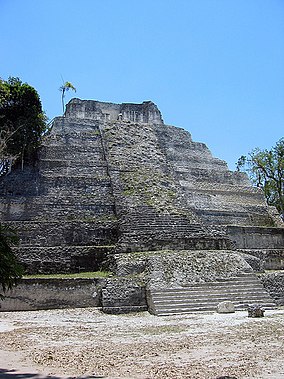
259:, a Mayan city constructed at the shore of the lake with the same name is the biggest site in the area. Between 1994 and 2008 a multitude of important buildings was restored here. The urban organization around the enormous sacred roads (sacbes) is understandable and visible again; now it’s possible to observe a variety of temples, palaces, ball-courts and observatories in state of restoration and from the top of Temple 216 one can admire a view over the whole site, the rainforest and the lake.
57:
537:
34:
217:. The project does not only work in one archaeological site, but in a region of 1,200 square kilometres (460 sq mi) including three gigantic sites and 14 sub-centers – the most populated area of the
249:. One of the temples, so called Temple C, was near to its collapse. That’s why the team restored it during the first two years. Today the island is one of the principal points of interest in the
95:
297:. This site will be the centre of future investigation to find new information about the Cultural Heritage of the Mayans and to prepare another important site for tourism.
49:
403:
478:
209:(Triángulo Cultural in Spanish) is a multidisciplinary project involving archaeologists, architects, restaurateurs, and biologists. It is situated in
594:
574:
569:
579:
396:
270:, is a Mayan oasis within the dense rainforest. Furthermore it’s the site with the highest number of restored buildings after
233:
The project, founded in 1994, started with over 300 Guatemalan workers and 12 scientists. The first work carried out was at
564:
389:
412:
242:
589:
218:
513:
483:
584:
323:
443:
493:
498:
508:
503:
250:
210:
79:
448:
8:
428:
293:
have nearly finished, in
January 2009 most of the workers have been moved to the site of
438:
346:
222:
164:
542:
453:
463:
423:
433:
458:
253:
and the cooperative of the project brings many tourists by boat to the island.
381:
246:
558:
473:
468:
110:
97:
56:
377:
Animations of the Mayan island
Topoxte (present status and reconstruction)
372:
Scientific documentation of the biggest Mayan research project (German)
309:
214:
83:
65:
341:
294:
282:
234:
33:
488:
278:
as the pyramids are very steep carrying temples and roofcombs.
518:
290:
286:
275:
271:
267:
263:
256:
238:
376:
371:
306:
Dieter
Richter, collaborator of The Cultural Triangle
241:. Here you find the only exposed architecture of the
532:
207:
Cultural
Triangle Yaxha-Nakum-Naranjo National Park
22:
Cultural
Triangle Yaxha-Nakum-Naranjo National Park
281:As the archaeological work and the restoration at
556:
411:
274:. The architecture shows strong influence from
266:. This site, 18 km (11 mi) north of
262:In 1997 the work was amplified to the site of
397:
404:
390:
310:Café Arqueológico Yaxhá, Flores, Guatemala
557:
385:
342:"Parque Nacional Yaxhá-Nakum-Naranjo"
324:"Yaxhá Nakúm Naranjo National Park"
175:Parque Nacional Yaxhá-Nakum-Naranjo
13:
14:
606:
575:Archaeological sites in Guatemala
365:
16:National park in Petén, Guatemala
580:1994 establishments in Guatemala
535:
55:
48:
32:
237:, an island within the lake of
570:Maya sites in Petén Department
334:
316:
1:
595:Petén–Veracruz moist forests
130:371.6 km (91,800 acres)
7:
565:National parks of Guatemala
413:National parks of Guatemala
10:
611:
300:
228:
590:Ramsar sites in Guatemala
530:
419:
349:Sites Information Service
199:
195:
187:
179:
171:
162:
158:
150:
142:
134:
126:
89:
75:
43:
31:
26:
21:
243:Maya Postclassic period
499:Riscos de Momostenango
146:202 (in 1940)
524:Yaxhá-Nakúm-Naranjo
509:Sierra del Lacandón
504:San José la Colonia
429:Cerro El Reformador
328:protectedplanet.net
151:Governing body
107: /
38:Temple 216 in Yaxha
439:Cuevas del Silvino
188:Reference no.
27:Triángulo Cultural
552:
551:
449:Grutas de Lanquín
223:Maya civilization
203:
202:
111:17.115°N 89.384°W
602:
585:Petén Department
545:
543:Guatemala portal
540:
539:
538:
514:Sipacate-Naranjo
479:Mirador Río Azul
454:Laguna del Tigre
406:
399:
392:
383:
382:
360:
359:
357:
355:
338:
332:
331:
320:
122:
121:
119:
118:
117:
112:
108:
105:
104:
103:
100:
59:
58:
52:
36:
19:
18:
610:
609:
605:
604:
603:
601:
600:
599:
555:
554:
553:
548:
541:
536:
534:
528:
484:Naciones Unidas
434:Cerro Miramundo
415:
410:
368:
363:
353:
351:
340:
339:
335:
322:
321:
317:
303:
231:
183:2 February 2006
167:
116:17.115; -89.384
115:
113:
109:
106:
101:
98:
96:
94:
93:
71:
70:
69:
68:
62:
61:
60:
39:
17:
12:
11:
5:
608:
598:
597:
592:
587:
582:
577:
572:
567:
550:
549:
547:
546:
531:
529:
527:
526:
521:
516:
511:
506:
501:
496:
491:
486:
481:
476:
471:
466:
461:
459:Laguna El Pino
456:
451:
446:
441:
436:
431:
426:
420:
417:
416:
409:
408:
401:
394:
386:
380:
379:
374:
367:
366:External links
364:
362:
361:
333:
314:
313:
312:
307:
302:
299:
230:
227:
219:Classic period
201:
200:
197:
196:
193:
192:
189:
185:
184:
181:
177:
176:
173:
169:
168:
165:Ramsar Wetland
163:
160:
159:
156:
155:
152:
148:
147:
144:
140:
139:
136:
132:
131:
128:
124:
123:
91:
87:
86:
77:
73:
72:
63:
54:
53:
47:
46:
45:
44:
41:
40:
37:
29:
28:
24:
23:
15:
9:
6:
4:
3:
2:
607:
596:
593:
591:
588:
586:
583:
581:
578:
576:
573:
571:
568:
566:
563:
562:
560:
544:
533:
525:
522:
520:
517:
515:
512:
510:
507:
505:
502:
500:
497:
495:
492:
490:
487:
485:
482:
480:
477:
475:
474:Los Aposentos
472:
470:
469:Las Victorias
467:
465:
464:Laguna Lachuá
462:
460:
457:
455:
452:
450:
447:
445:
442:
440:
437:
435:
432:
430:
427:
425:
424:Cerro El Baúl
422:
421:
418:
414:
407:
402:
400:
395:
393:
388:
387:
384:
378:
375:
373:
370:
369:
350:
348:
343:
337:
329:
325:
319:
315:
311:
308:
305:
304:
298:
296:
292:
288:
284:
279:
277:
273:
269:
265:
260:
258:
254:
252:
248:
245:in the whole
244:
240:
236:
226:
224:
220:
216:
212:
208:
198:
194:
190:
186:
182:
178:
174:
172:Official name
170:
166:
161:
157:
153:
149:
145:
141:
137:
133:
129:
125:
120:
92:
88:
85:
81:
78:
74:
67:
51:
42:
35:
30:
25:
20:
523:
352:. Retrieved
345:
336:
327:
318:
280:
261:
255:
232:
206:
204:
247:Petén Basin
135:Established
114: /
90:Coordinates
559:Categories
444:El Rosario
180:Designated
102:89°23′02″W
99:17°06′54″N
494:Río Dulce
215:Guatemala
84:Guatemala
66:Guatemala
354:25 April
143:Visitors
76:Location
301:Sources
295:Naranjo
283:Topoxte
235:Topoxte
229:History
221:of the
154:private
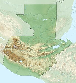
64:Map of
489:Pacaya
347:Ramsar
519:Tikal
291:Nakum
287:Yaxha
276:Tikal
272:Tikal
268:Yaxha
264:Nakum
257:Yaxha
251:Petén
239:Yaxha
211:Petén
80:Petén
356:2018
289:and
205:The
191:1599
138:2003
127:Area
561::
344:.
326:.
285:,
225:.
213:,
82:,
405:e
398:t
391:v
358:.
330:.
Text is available under the Creative Commons Attribution-ShareAlike License. Additional terms may apply.

