899:
871:
836:
808:
773:
745:
710:
682:
647:
145:
50:
268:
announced the reform of local government areas. The intention of the reform was to improve and expand the delivery of services to towns and communities across the
Northern Territory by establishing eleven new shires. The West Arnhem Shire was created on 1 July 2008. Elections of Shire Councillors
983:
363:
976:
1220:
969:
932:
131:
119:
278:
The Region formerly consisted of unincorporated land, plus small areas under the control of
Community Government Councils or incorporated communities:
339:
for a property. The bounded areas are called "localities" with those localities associated with
Aboriginal communities being called "communities".
992:
245:
1210:
17:
1215:
898:
870:
506:"3218.0 – Regional Population Growth, Australia, 2017-18: Population Estimates by Local Government Area (ASGS 2018), 2017 to 2018"
835:
807:
772:
744:
709:
681:
646:
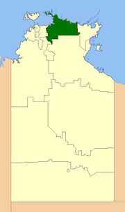
256:. The region covers an area of 49,675 square kilometres (19,180 sq mi) and had a population of 6,902 in June 2018.
265:
358:
595:
1044:
883:
848:
820:
785:
757:
722:
694:
659:
624:
513:
427:
388:
287:
1109:
446:
335:
Land within the West Arnhem Region was divided during 2007 into bounded areas for the purpose of creating an
297:
214:
199:
169:
124:
887:
824:
761:
698:
292:
107:
852:
789:
726:
663:
628:
466:
302:
1177:
1027:
408:
353:
100:
537:
505:
961:
924:
1033:
475:
456:
436:
417:
398:
1167:
1162:
1225:
1081:
136:
8:
1190:
1055:
178:
1115:
1050:
249:
207:
40:
1172:
1154:
1086:
1076:
348:
313:
West Arnhem
Regional Council is divided into four wards with three councillors each:
224:
219:
1136:
1091:
919:
1022:
1011:
282:
144:
1204:
1144:
1006:
947:
934:
1060:
569:
1101:
191:
184:
112:
1120:
538:"Local Government Act CHANGES TO LOCAL GOVERNMENT AREAS AND COUNCILS"
991:
49:
914:
156:
1038:
1016:
336:
272:
As of 2017 the Mayor of the West Arnhem Shire was
Matthew Ryan.
882:
847:
819:
784:
756:
721:
693:
658:
623:
275:
On 1 January 2014, the Shire became the West Arnhem Region.
29:
Local government area in the
Northern Territory, Australia
1221:Local government areas of the Northern Territory
1202:
993:Local government areas of the Northern Territory
164:
977:
605:. Northern Territory Government. 2 April 2007
330:
526:Estimated resident population, 30 June 2018.
596:"Localities within West Arnhem Shire (sic)"
570:"Northern Territory localities and suburbs"
536:TOLLNER, DAVID WILLIAM (18 December 2013).
472:
453:
433:
414:
395:
984:
970:
897:
869:
834:
806:
771:
743:
708:
680:
645:
547:. Northern Territory Government. p. 3
143:
48:
588:
562:
84:49,675 km (19,179.6 sq mi)
529:
500:
498:
496:
535:
252:, Australia and is administered by the
14:
1203:
965:
545:Northern Territory Government Gazette
493:
379:
1211:Populated places established in 2008
1193:, i.e. do not have local government.
1189:Note: (*) refers to places that are
915:West Arhnem Regional Council website
24:
762:"Maningrida (suburb and locality)"
727:"Maningrida (suburb and locality)"
629:"Gunbalanya (suburb and locality)"
25:
1237:
1045:Northern Territory Rates Act Area
908:
857:Australian Census 2021 QuickStats
825:"Minjilang (suburb and locality)"
794:Australian Census 2021 QuickStats
790:"Minjilang (suburb and locality)"
731:Australian Census 2021 QuickStats
668:Australian Census 2021 QuickStats
633:Australian Census 2021 QuickStats
68:0.138943/km (0.359861/sq mi)
1216:2008 establishments in Australia
557:with effect from 1 January 2014:
888:"Warruwi (suburb and locality)"
884:Australian Bureau of Statistics
876:
853:"Warruwi (suburb and locality)"
849:Australian Bureau of Statistics
841:
821:Australian Bureau of Statistics
813:
786:Australian Bureau of Statistics
778:
758:Australian Bureau of Statistics
723:Australian Bureau of Statistics
695:Australian Bureau of Statistics
660:Australian Bureau of Statistics
625:Australian Bureau of Statistics
576:. Northern Territory Government
514:Australian Bureau of Statistics
510:Australian Bureau of Statistics
269:were held on 25 October 2008.
750:
715:
699:"Jabiru (suburb and locality)"
687:
664:"Jabiru (suburb and locality)"
652:
617:
369:
13:
1:
486:
342:
266:Northern Territory Government
215:Unincorporated Top End Region
200:Unincorporated Top End Region
254:West Arnhem Regional Council
18:West Arnhem Regional Council
7:
10:
1242:
1028:Darwin Waterfront Precinct
331:Localities and communities
259:
172:around West Arnhem Region:
1187:
1153:
1135:
1100:
1069:
999:
230:
167:
163:
151:
142:
130:
118:
106:
96:
88:
80:
72:
64:
56:
47:
34:
308:
120:Territory electorate(s)
948:12.66694°S 132.83306°E
892:Australian Census 2021
829:Australian Census 2021
766:Australian Census 2021
703:Australian Census 2021
1039:Marrakai-Douglas Daly
603:Place Names Committee
574:Place Names Committee
246:local government area
1191:unincorporated areas
953:-12.66694; 132.83306
293:Gunbalanya Community
288:Maningrida Community
264:In October 2006 the
944: /
298:Minjilang Community
132:Federal division(s)
250:Northern Territory
242:West Arnhem Region
204:West Arnhem Region
157:West Arnhem Region
41:Northern Territory
36:West Arnhem Region
1198:
1197:
1155:Central Australia
484:
483:
303:Warruwi Community
238:
237:
234:
233:
60:6,902 (2018)
16:(Redirected from
1233:
1137:Barkly Tableland
1070:Katherine Region
986:
979:
972:
963:
962:
959:
958:
956:
955:
954:
949:
945:
942:
941:
940:
937:
902:
901:
895:
886:(28 June 2022).
880:
874:
873:
867:
865:
863:
851:(28 June 2022).
845:
839:
838:
832:
823:(28 June 2022).
817:
811:
810:
804:
802:
800:
788:(28 June 2022).
782:
776:
775:
769:
760:(28 June 2022).
754:
748:
747:
741:
739:
737:
725:(28 June 2022).
719:
713:
712:
706:
697:(28 June 2022).
691:
685:
684:
678:
676:
674:
662:(28 June 2022).
656:
650:
649:
643:
641:
639:
627:(28 June 2022).
621:
615:
614:
612:
610:
600:
592:
586:
585:
583:
581:
566:
560:
559:
554:
552:
542:
533:
527:
525:
523:
521:
502:
474:
455:
435:
416:
397:
374:
373:
165:
159:
147:
52:
43:
37:
32:
31:
21:
1241:
1240:
1236:
1235:
1234:
1232:
1231:
1230:
1201:
1200:
1199:
1194:
1183:
1149:
1131:
1096:
1065:
995:
990:
952:
950:
946:
943:
938:
935:
933:
931:
930:
911:
906:
905:
881:
877:
861:
859:
846:
842:
818:
814:
798:
796:
783:
779:
755:
751:
735:
733:
720:
716:
692:
688:
672:
670:
657:
653:
637:
635:
622:
618:
608:
606:
598:
594:
593:
589:
579:
577:
568:
567:
563:
550:
548:
540:
534:
530:
519:
517:
516:. 27 March 2019
504:
503:
494:
489:
372:
359:Van Diemen Gulf
345:
333:
311:
262:
155:
65: • Density
39:
38:
35:
30:
23:
22:
15:
12:
11:
5:
1239:
1229:
1228:
1223:
1218:
1213:
1196:
1195:
1188:
1185:
1184:
1182:
1181:
1175:
1170:
1168:Central Desert
1165:
1159:
1157:
1151:
1150:
1148:
1147:
1141:
1139:
1133:
1132:
1130:
1129:
1124:
1118:
1113:
1106:
1104:
1098:
1097:
1095:
1094:
1089:
1084:
1079:
1073:
1071:
1067:
1066:
1064:
1063:
1058:
1053:
1048:
1042:
1036:
1031:
1025:
1020:
1014:
1009:
1003:
1001:
997:
996:
989:
988:
981:
974:
966:
928:
927:
925:Policy details
922:
917:
910:
909:External links
907:
904:
903:
875:
840:
812:
777:
749:
714:
686:
651:
616:
587:
561:
528:
491:
490:
488:
485:
482:
481:
479:
469:
463:
462:
460:
450:
443:
442:
440:
430:
424:
423:
421:
411:
405:
404:
402:
392:
385:
384:
381:
378:
371:
368:
367:
366:
361:
356:
351:
344:
341:
332:
329:
328:
327:
324:
323:Maningrida (3)
321:
318:
317:Gunbalanya (3)
310:
307:
306:
305:
300:
295:
290:
285:
283:Town of Jabiru
261:
258:
236:
235:
232:
231:
228:
227:
222:
217:
211:
210:
205:
202:
196:
195:
188:
181:
175:
174:
161:
160:
153:
149:
148:
140:
139:
134:
128:
127:
122:
116:
115:
110:
104:
103:
98:
94:
93:
90:
86:
85:
82:
78:
77:
74:
70:
69:
66:
62:
61:
58:
54:
53:
45:
44:
28:
9:
6:
4:
3:
2:
1238:
1227:
1224:
1222:
1219:
1217:
1214:
1212:
1209:
1208:
1206:
1192:
1186:
1179:
1176:
1174:
1171:
1169:
1166:
1164:
1163:Alice Springs
1161:
1160:
1158:
1156:
1152:
1146:
1143:
1142:
1140:
1138:
1134:
1128:
1125:
1122:
1119:
1117:
1114:
1111:
1108:
1107:
1105:
1103:
1099:
1093:
1090:
1088:
1085:
1083:
1082:Victoria Daly
1080:
1078:
1075:
1074:
1072:
1068:
1062:
1059:
1057:
1054:
1052:
1049:
1046:
1043:
1040:
1037:
1035:
1032:
1029:
1026:
1024:
1021:
1018:
1015:
1013:
1010:
1008:
1005:
1004:
1002:
1000:Darwin Region
998:
994:
987:
982:
980:
975:
973:
968:
967:
964:
960:
957:
926:
923:
921:
918:
916:
913:
912:
900:
893:
889:
885:
879:
872:
858:
854:
850:
844:
837:
830:
826:
822:
816:
809:
795:
791:
787:
781:
774:
767:
763:
759:
753:
746:
732:
728:
724:
718:
711:
704:
700:
696:
690:
683:
669:
665:
661:
655:
648:
634:
630:
626:
620:
604:
597:
591:
575:
571:
565:
558:
546:
539:
532:
515:
511:
507:
501:
499:
497:
492:
480:
477:
470:
468:
465:
464:
461:
458:
451:
449:(Mission Bay)
448:
445:
444:
441:
438:
431:
429:
426:
425:
422:
419:
412:
410:
407:
406:
403:
400:
393:
390:
387:
386:
382:
376:
375:
365:
362:
360:
357:
355:
352:
350:
347:
346:
340:
338:
325:
322:
319:
316:
315:
314:
304:
301:
299:
296:
294:
291:
289:
286:
284:
281:
280:
279:
276:
273:
270:
267:
257:
255:
251:
247:
243:
229:
226:
223:
221:
218:
216:
213:
212:
209:
206:
203:
201:
198:
197:
194:
193:
189:
187:
186:
182:
180:
177:
176:
173:
171:
166:
162:
158:
154:
150:
146:
141:
138:
135:
133:
129:
126:
123:
121:
117:
114:
111:
109:
105:
102:
99:
95:
91:
87:
83:
79:
75:
71:
67:
63:
59:
55:
51:
46:
42:
33:
27:
19:
1126:
1056:Tiwi Islands
929:
891:
878:
860:. Retrieved
856:
843:
828:
815:
797:. Retrieved
793:
780:
765:
752:
734:. Retrieved
730:
717:
702:
689:
671:. Retrieved
667:
654:
636:. Retrieved
632:
619:
607:. Retrieved
602:
590:
578:. Retrieved
573:
564:
556:
549:. Retrieved
544:
531:
518:. Retrieved
509:
334:
312:
277:
274:
271:
263:
253:
241:
239:
190:
183:
168:
97:Council seat
92:Matthew Ryan
26:
1226:Arnhem Land
1127:West Arnhem
1116:East Arnhem
1102:Arnhem Land
951: /
939:132°49′59″E
920:Map of LGAs
380:Population
370:Communities
364:West Arnhem
208:East Arnhem
192:Arafura Sea
185:Arafura Sea
113:Arnhem Land
73:Established
1205:Categories
1173:MacDonnell
1087:Roper Gulf
1051:Palmerston
1034:Litchfield
936:12°40′01″S
520:25 October
487:References
428:Maningrida
391:(Oenpelli)
389:Gunbalanya
377:Community
343:Localities
326:Barrah (3)
320:Kakadu (3)
225:Roper Gulf
220:Roper Gulf
57:Population
1121:Nhulunbuy
1110:Alyangula
1092:West Daly
1077:Katherine
447:Minjilang
1017:Cox-Daly
1012:Coomalie
609:27 April
580:25 April
551:26 April
137:Lingiari
1007:Belyuen
862:28 June
799:28 June
736:28 June
673:28 June
638:28 June
467:Warruwi
432:2,518 (
394:1,177 (
349:Cobourg
337:address
260:History
248:of the
152:Website
125:Arafura
1178:Yulara
1145:Barkly
1061:Wagait
1023:Darwin
896:
868:
833:
805:
770:
742:
707:
679:
644:
409:Jabiru
354:Kakadu
108:Region
101:Jabiru
599:(PDF)
541:(PDF)
471:432 (
452:265 (
413:755 (
309:Wards
244:is a
89:Mayor
864:2022
801:2022
738:2022
675:2022
640:2022
611:2019
582:2019
553:2019
522:2019
476:2021
457:2021
437:2021
418:2021
399:2021
383:Map
240:The
179:Tiwi
170:LGAs
81:Area
76:2008
473:SAL
454:SAL
434:SAL
415:SAL
396:SAL
1207::
890:.
855:.
827:.
792:.
764:.
729:.
701:.
666:.
631:.
601:.
572:.
555:.
543:.
512:.
508:.
495:^
1180:*
1123:*
1112:*
1047:*
1041:*
1030:*
1019:*
985:e
978:t
971:v
894:.
866:.
831:.
803:.
768:.
740:.
705:.
677:.
642:.
613:.
584:.
524:.
478:)
459:)
439:)
420:)
401:)
20:)
Text is available under the Creative Commons Attribution-ShareAlike License. Additional terms may apply.

