112:
764:
96:
645:
56:
81:
810:
71:
611:
635:
337:
709:
119:
417:). The average annual temperature in Tomika is 15.1 °C. The average annual rainfall is 2074 mm with September as the wettest month. The temperatures are highest on average in August, at around 27.8 °C, and lowest in January, at around 3.3 °C.
565:
cadastral reforms, Kamo
District within Gifu Prefecture was created, and the village of Tomida was established on April 1, 1897. Tomida merged with the village of Kajita on July 1, 1954, forming the village of Tomika (taking its name from
594:
Tomika has one public elementary school operated by the town government, and one public junior high school operated jointly between Tomika and neighbouring
Minokamo. The town does not have a high school.
143:
111:
763:
95:
386:
of 340 persons per km, in 1962 households. The total area of the town was 57.09 square kilometres (22.04 sq mi).
410:
flow through the town. The town has a climate characterized by characterized by hot and humid summers, and mild winters (
1109:
614:
1133:
731:
411:
753:
713:
809:
447:
Per
Japanese census data, the population of Tomika has remained relatively steady over the past 50 years.
638:
80:
55:
1084:
781:
1091:
648:
187:
175:
1038:
1023:
974:
935:
582:冶田) Tomika was elevated to town status on July 1, 1974. A referendum to merge into the city of
363:
70:
1128:
1067:
1079:
791:
298:
199:
8:
1055:
1013:
957:
367:
279:
216:
991:
746:
558:
383:
211:
761:
562:
962:
692:
1018:
1096:
984:
767:
371:
204:
192:
1072:
1033:
950:
919:
909:
879:
869:
681:
619:
583:
434:
399:
46:
1122:
940:
839:
739:
544:
403:
158:
145:
945:
834:
394:
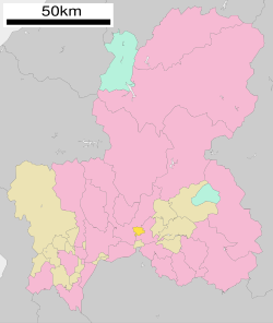
Tomika is located in south-central Gifu
Prefecture. The city is bordered by
1060:
1048:
1028:
884:
874:
854:
1006:
610:
1001:
979:
967:
889:
407:
914:
899:
864:
859:
844:
829:
548:
429:
395:
379:
824:
270:
553:
634:
894:
721:
402:
to the east. Mount
Nashiwari is within the town's boundaries. The
326:
996:
667:
336:
904:
708:
275:
17:
378:. As of 31 December 2018, the town had an estimated
849:
375:
180:
799:
776:
316:
Takida 1511, Tomika-chō, Kamo-gun, Gifu-ken 501-3392
16:"Tomika" redirects here. Not to be confused with
1120:
543:The area around Tomika was part of traditional
355:
420:
349:
34:
747:
754:
740:
340:Matsui sake brewery, established in 1795
335:
1121:
464:
735:
557:territory controlled directly by the
100:Location of Tomika in Gifu Prefecture
244:16.82 km (6.49 sq mi)
13:
1110:List of mergers in Gifu Prefecture
615:Nagaragawa Railway Etsumi-Nan Line
459:
14:
1145:
701:
598:
808:
762:
707:
643:
633:
609:
117:
110:
94:
79:
69:
54:
668:Tomika town official statistics
442:
686:
675:
661:
118:
1:
654:
412:Köppen climate classification
693:Tomika population statistics
589:
389:
7:
421:Neighbouring municipalities
356:
10:
1150:
627:
603:
538:
15:
1107:
928:
817:
806:
790:
774:
477:—
350:
320:
312:
304:
294:
286:
269:
261:
253:
248:
240:
235:
227:
222:
210:
198:
186:
174:
139:
105:
93:
65:
53:
44:
35:
28:
1134:Towns in Gifu Prefecture
586:, was defeated in 2004.
32:
649:National Route 418
265:340/km (880/sq mi)
159:35.48472°N 136.979639°E
639:Tōkai-Kanjō Expressway
341:
451:Historical population
339:
716:at Wikimedia Commons
299:Enkianthus perulatus
262: • Density
164:35.48472; 136.979639
23:Town in Chūbu, Japan
682:Tomika climate data
452:
280:Japan Standard Time
155: /
559:Tokugawa shogunate
450:
384:population density
342:
254: • Total
241: • Total
228: • Mayor
1116:
1115:
785:
712:Media related to
563:Meiji restoration
536:
535:
334:
333:
305:Phone number
1141:
1024:Higashishirakawa
975:Hashima District
936:Anpachi District
812:
779:
766:
756:
749:
742:
733:
732:
728:
725:
724:
722:Official website
711:
695:
690:
684:
679:
673:
672:
665:
647:
646:
637:
613:
561:. With the post
466:
461:
453:
449:
426:Gifu Prefecture
398:to the west and
361:
359:
353:
352:
330:
329:
327:Official website
170:
169:
167:
166:
165:
160:
156:
153:
152:
151:
148:
121:
120:
114:
98:
83:
73:
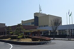
60:Tomika Town Hall
58:
39:
38:
37:
26:
25:
1149:
1148:
1144:
1143:
1142:
1140:
1139:
1138:
1119:
1118:
1117:
1112:
1103:
1068:Motosu District
924:
813:
804:
786:
770:
768:Gifu Prefecture
760:
726:
720:
719:
704:
699:
698:
691:
687:
680:
676:
670:
666:
662:
657:
644:
630:
606:
601:
592:
551:, the area was
541:
445:
423:
392:
382:of 5,714 and a
372:Gifu Prefecture
347:
325:
324:
231:Hiromichi Sakai
163:
161:
157:
154:
149:
146:
144:
142:
141:
135:
134:
133:
132:
129:
128:
127:
126:
122:
101:
89:
88:
87:
86:
77:
76:
61:
49:
40:
33:
31:
24:
21:
12:
11:
5:
1147:
1137:
1136:
1131:
1114:
1113:
1108:
1105:
1104:
1102:
1101:
1100:
1099:
1089:
1088:
1087:
1077:
1076:
1075:
1065:
1064:
1063:
1053:
1052:
1051:
1046:
1041:
1036:
1031:
1026:
1021:
1011:
1010:
1009:
1004:
999:
989:
988:
987:
982:
972:
971:
970:
965:
955:
954:
953:
948:
943:
932:
930:
926:
925:
923:
922:
917:
912:
907:
902:
897:
892:
887:
882:
877:
872:
867:
862:
857:
852:
847:
842:
837:
832:
827:
821:
819:
815:
814:
807:
805:
803:
802:
796:
794:
788:
787:
775:
772:
771:
759:
758:
751:
744:
736:
730:
729:
717:
703:
702:External links
700:
697:
696:
685:
674:
659:
658:
656:
653:
652:
651:
641:
629:
626:
625:
624:
623:
622:
605:
602:
600:
599:Transportation
597:
591:
588:
547:. During the
540:
537:
534:
533:
530:
527:
523:
522:
519:
516:
512:
511:
508:
505:
501:
500:
497:
494:
490:
489:
486:
483:
479:
478:
475:
472:
468:
467:
462:
457:
444:
441:
440:
439:
438:
437:
432:
422:
419:
391:
388:
332:
331:
322:
318:
317:
314:
310:
309:
306:
302:
301:
296:
292:
291:
288:
284:
283:
273:
267:
266:
263:
259:
258:
255:
251:
250:
246:
245:
242:
238:
237:
233:
232:
229:
225:
224:
220:
219:
214:
208:
207:
202:
196:
195:
190:
184:
183:
178:
172:
171:
137:
136:
130:
124:
123:
116:
115:
109:
108:
107:
106:
103:
102:
99:
91:
90:
84:
78:
74:
68:
67:
66:
63:
62:
59:
51:
50:
45:
42:
41:
29:
22:
9:
6:
4:
3:
2:
1146:
1135:
1132:
1130:
1127:
1126:
1124:
1111:
1106:
1098:
1095:
1094:
1093:
1092:Yōrō District
1090:
1086:
1083:
1082:
1081:
1078:
1074:
1071:
1070:
1069:
1066:
1062:
1059:
1058:
1057:
1056:Kani District
1054:
1050:
1047:
1045:
1042:
1040:
1037:
1035:
1032:
1030:
1027:
1025:
1022:
1020:
1017:
1016:
1015:
1014:Kamo District
1012:
1008:
1005:
1003:
1000:
998:
995:
994:
993:
990:
986:
983:
981:
978:
977:
976:
973:
969:
966:
964:
961:
960:
959:
958:Fuwa District
956:
952:
949:
947:
944:
942:
939:
938:
937:
934:
933:
931:
927:
921:
918:
916:
913:
911:
908:
906:
903:
901:
898:
896:
893:
891:
888:
886:
883:
881:
878:
876:
873:
871:
868:
866:
863:
861:
858:
856:
853:
851:
848:
846:
843:
841:
838:
836:
833:
831:
828:
826:
823:
822:
820:
816:
811:
801:
798:
797:
795:
793:
789:
783:
778:
773:
769:
765:
757:
752:
750:
745:
743:
738:
737:
734:
727:(in Japanese)
723:
718:
715:
710:
706:
705:
694:
689:
683:
678:
671:(in Japanese)
669:
664:
660:
650:
642:
640:
636:
632:
631:
621:
618:
617:
616:
612:
608:
607:
596:
587:
585:
581:
577:
573:
569:
564:
560:
556:
555:
550:
546:
545:Mino Province
531:
528:
525:
524:
520:
517:
514:
513:
509:
506:
503:
502:
498:
495:
492:
491:
487:
484:
481:
480:
476:
473:
470:
469:
463:
458:
455:
454:
448:
436:
433:
431:
428:
427:
425:
424:
418:
416:
413:
409:
405:
401:
397:
387:
385:
381:
377:
373:
369:
368:Kamo District
365:
358:
346:
338:
328:
323:
319:
315:
311:
307:
303:
300:
297:
293:
289:
285:
281:
277:
274:
272:
268:
264:
260:
256:
252:
247:
243:
239:
234:
230:
226:
221:
218:
215:
213:
209:
206:
203:
201:
197:
194:
191:
189:
185:
182:
179:
177:
173:
168:
150:136°58′46.7″E
140:Coordinates:
138:
113:
104:
97:
92:
82:
72:
64:
57:
52:
48:
43:
27:
19:
1129:Tomika, Gifu
1080:Ōno District
1043:
992:Ibi District
855:Kakamigahara
714:Tomika, Gifu
688:
677:
663:
593:
579:
575:
571:
567:
552:
542:
446:
443:Demographics
414:
408:Tsubo Rivers
393:
344:
343:
308:0574-54-2111
287:City symbols
890:Nakatsugawa
366:located in
162: /
1123:Categories
963:Sekigahara
655:References
549:Edo period
380:population
357:Tomika-chō
249:Population
223:Government
200:Prefecture
1085:Shirakawa
1039:Shirakawa
985:Kasamatsu
929:Districts
792:Core city
590:Education
390:Geography
271:Time zone
147:35°29′5″N
1073:Kitagata
1034:Sakahogi
951:Wanouchi
920:Yamagata
910:Takayama
880:Mizunami
870:Minokamo
584:Minokamo
435:Minokamo
400:Minokamo
212:District
1019:Hichisō
997:Ibigawa
941:Anpachi
840:Hashima
782:capital
628:Highway
604:Railway
574:田) and
539:History
404:Kawaura
321:Website
313:Address
176:Country
1061:Mitake
1049:Yaotsu
1044:Tomika
1029:Kawabe
905:Tajimi
885:Motosu
875:Mizuho
818:Cities
620:Tomika
578:jita (
554:tenryō
488:+15.9%
345:Tomika
295:- Tree
290:
188:Region
131:
125:Tomika
30:Tomika
18:Tomica
1002:Ikeda
980:Ginan
968:Tarui
895:Ōgaki
850:Kaizu
532:+2.0%
529:5,626
526:2020
521:−5.5%
518:5,516
515:2010
510:−1.1%
507:5,835
504:2000
499:+4.7%
496:5,898
493:1990
485:5,635
482:1980
474:4,863
471:1970
376:Japan
362:is a
276:UTC+9
257:5,714
193:Chūbu
181:Japan
1097:Yōrō
946:Gōdo
915:Toki
900:Seki
865:Mino
860:Kani
845:Hida
835:Gujō
830:Gero
800:Gifu
777:Gifu
570:da (
568:Tomi
460:Pop.
456:Year
430:Seki
406:and
396:Seki
364:town
236:Area
217:Kamo
205:Gifu
85:Seal
75:Flag
47:Town
1007:Ōno
825:Ena
415:Cfa
351:富加町
36:富加町
1125::
576:Ka
465:±%
374:,
370:,
354:,
784:)
780:(
755:e
748:t
741:v
580:加
572:富
360:)
348:(
282:)
278:(
20:.
Text is available under the Creative Commons Attribution-ShareAlike License. Additional terms may apply.


