196:
57:
26:
211:
223:
462:
41:
64:
195:
180:, one of the Philippines most important cities and ports, is located at the head of the bay, making the bay one of the busiest and often the site of shipping accidents. The
302:
335:
210:
527:
503:
328:
56:
445:
321:
247:
100:
542:
537:
496:
277:
Edgar A. de Jesus; Dolores
Ariadne D. Diamante-Fabunan; Cleto Nañola; Alan T. White; Hermenegildo J. Cabangon (2001).
291:
222:
522:
532:
489:
276:
25:
278:
181:
8:
477:
287:
313:
31:
473:
202:
177:
461:
280:
Coastal
Environmental Profile of the Sarangani Bay Area, Mindanao, Philippines
516:
375:
173:
115:
102:
423:
345:
469:
407:
169:
165:
86:
428:
359:
216:
Sarangani Bay is one of the protected seascapes in the
Philippines.
161:
40:
157:
343:
514:
248:"2 vessels collide off Sarangani Bay; 2 missing"
93:
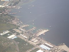
201:An aerial view of the bay showing the port of
497:
329:
303:"First dugong sighting in Sarangani recorded"
300:
286:. The Coastal Resource Management Project.
184:, created in 1992, is named after the bay.
30:View of the bay along the road en route to
504:
490:
336:
322:
528:Protected seascapes of the Philippines
515:
468:This article about a location in the
317:
63:
456:
13:
446:Protected areas of the Philippines
270:
14:
554:
460:
401:Game refuge and bird sanctuaries
221:
209:
194:
62:
55:
39:
24:
301:Marita Moaje (August 7, 2024).
160:located on the southern tip of
240:
1:
233:
476:. You can help Knowledge by
7:
543:Philippines geography stubs
538:Landforms of South Cotabato
45:North part of Sarangani Bay
10:
559:
455:
187:
442:
417:Watershed forest reserves
416:
400:
384:
368:
352:
143:
135:
131:
92:
81:
50:
38:
23:
18:
147:16 km (9.9 mi)
523:Bays of the Philippines
228:Another view of the bay
139:33 km (21 mi)
533:Landforms of Sarangani
307:Philippine News Agency
182:province of Sarangani
168:. It opens up to the
369:Protected landscapes
385:Protected seascapes
344:Protected areas in
203:General Santos
112: /
85:Southern Mindanao,
485:
484:
453:
452:
151:
150:
116:5.967°N 125.183°E
550:
506:
499:
492:
464:
457:
338:
331:
324:
315:
314:
310:
297:
285:
264:
263:
261:
259:
254:. 10 August 2011
244:
225:
213:
198:
127:
126:
124:
123:
122:
117:
113:
110:
109:
108:
105:
95:
66:
65:
59:
43:
28:
16:
15:
558:
557:
553:
552:
551:
549:
548:
547:
513:
512:
511:
510:
454:
449:
438:
412:
396:
380:
364:
348:
342:
294:
283:
273:
271:Further reading
268:
267:
257:
255:
252:Philippine Star
246:
245:
241:
236:
229:
226:
217:
214:
205:
199:
190:
120:
118:
114:
111:
106:
103:
101:
99:
98:
77:
76:
75:
74:
73:
72:
71:
67:
46:
34:
32:Glan, Sarangani
12:
11:
5:
556:
546:
545:
540:
535:
530:
525:
509:
508:
501:
494:
486:
483:
482:
465:
451:
450:
443:
440:
439:
437:
436:
433:
432:
431:
420:
418:
414:
413:
411:
410:
404:
402:
398:
397:
395:
394:
388:
386:
382:
381:
379:
378:
372:
370:
366:
365:
363:
362:
356:
354:
350:
349:
341:
340:
333:
326:
318:
312:
311:
298:
292:
272:
269:
266:
265:
238:
237:
235:
232:
231:
230:
227:
220:
218:
215:
208:
206:
200:
193:
189:
186:
178:General Santos
149:
148:
145:
141:
140:
137:
133:
132:
129:
128:
121:5.967; 125.183
96:
90:
89:
83:
79:
78:
69:
68:
61:
60:
54:
53:
52:
51:
48:
47:
44:
36:
35:
29:
21:
20:
9:
6:
4:
3:
2:
555:
544:
541:
539:
536:
534:
531:
529:
526:
524:
521:
520:
518:
507:
502:
500:
495:
493:
488:
487:
481:
479:
475:
471:
466:
463:
459:
458:
448:
447:
441:
434:
430:
427:
426:
425:
422:
421:
419:
415:
409:
406:
405:
403:
399:
393:
392:Sarangani Bay
390:
389:
387:
383:
377:
376:Mount Matutum
374:
373:
371:
367:
361:
358:
357:
355:
353:Natural parks
351:
347:
339:
334:
332:
327:
325:
320:
319:
316:
308:
304:
299:
295:
293:971-92289-7-0
289:
282:
281:
275:
274:
253:
249:
243:
239:
224:
219:
212:
207:
204:
197:
192:
191:
185:
183:
179:
175:
174:Pacific Ocean
171:
167:
163:
159:
155:
154:Sarangani Bay
146:
142:
138:
134:
130:
125:
97:
91:
88:
84:
80:
70:Sarangani Bay
58:
49:
42:
37:
33:
27:
22:
19:Sarangani Bay
17:
478:expanding it
467:
444:
424:Allah Valley
391:
346:Soccsksargen
306:
279:
256:. Retrieved
251:
242:
153:
152:
470:Philippines
408:Lake Buluan
170:Celebes Sea
166:Philippines
136:Max. length
119: /
94:Coordinates
87:Philippines
517:Categories
234:References
144:Max. width
429:Lake Sebu
360:Mount Apo
258:13 August
435:Libungan
162:Mindanao
107:125°11′E
82:Location
188:Gallery
172:on the
164:in the
104:05°58′N
290:
472:is a
284:(PDF)
156:is a
474:stub
288:ISBN
260:2011
158:bay
519::
305:.
250:.
176:.
505:e
498:t
491:v
480:.
337:e
330:t
323:v
309:.
296:.
262:.
Text is available under the Creative Commons Attribution-ShareAlike License. Additional terms may apply.


