289:
60:
537:
339:
Most settlements on the island are along the southwestern shore in Hasvik, but there are scattered settlements in other areas of the island as well. The northeastern part of the island in
Hammerfest has some settlements as well with some roads, but the roads are not all connected to each other.
389:. Later in February and March, fighting between Norwegian volunteers and German soldiers resulted in six dead Norwegians and fourteen captured, while between 30 and 100 German soldiers were killed.
344:
98:
285:. It is often claimed to be "one of the most beautiful" of the islands in Norway. In 2018, the population of the island was 1,100.
296:
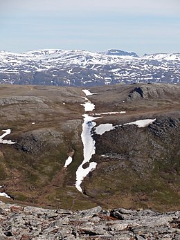
The island is very rocky and mountainous. The highest point on the island is the 659-metre (2,162 ft) tall mountain
274:
547:
363:
562:
541:
436:
511:
324:. The island of Sørøya has no bridge or tunnel access, only a regular ferry route from the village of
288:
59:
282:
209:
138:
479:
268:
46:
359:, a guerrilla group operated on the island, fighting against the occupying German forces.
321:
8:
567:
278:
213:
252:
31:
514:[Norwegian teenage soldiers fought against the Germans] (in Norwegian). nrk.no
325:
309:
300:
on the southern shore of the island. The coastline is very jagged and has numerous
312:
strait to the south. Across the Sørøysundet to the south are three large islands:
572:
333:
428:
556:
305:
113:
100:
485:
382:
356:
277:. The 811-square-kilometre (313 sq mi) island is divided between
313:
329:
456:
367:
297:
175:
370:
366:, 525 Norwegian civilians were evacuated from Sørøya by four British
304:
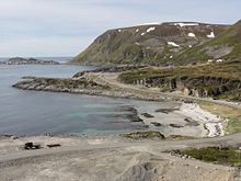
that cut inland from the open ocean. The island is surrounded by the
410:
378:
374:
199:
82:
317:
536:
86:
301:
362:
On 15 February 1945, less than three months before the
258:
38:
478:
477:Rosef, Thea; Hjardar, Hanna Kristin (2020-10-17).
554:
512:"Norske tenåringssoldater kjempet mot tyskerne"
275:Norway's fourth largest island in terms of area
242:
23:
336:is located on the southern tip of the island.
449:
476:
457:"Statistisk årbok 2009: Geografisk oversikt"
58:
509:
287:
505:
503:
408:
555:
385:. The rescue operation was code named
404:
402:
500:
13:
483:[Escape From The Island].
399:
14:
584:
529:
292:Scene in the North West of Sørøya
133:811 km (313 sq mi)
535:
350:
470:
421:
1:
510:Ytreberg, Rune (2011-04-11).
409:Askheim, Svein (2009-02-15).
392:
364:end of World War II in Europe
159:23.3 km (14.48 mi)
151:64.3 km (39.95 mi)
7:
10:
589:
16:Island in Finnmark, Norway
429:"Informasjon om stadnamn"
373:and brought to safety in
232:
224:
219:
205:
195:
186:
181:
171:
167:659 m (2162 ft)
163:
155:
147:
137:
129:
92:
78:
73:
69:
57:
283:Hammerfest Municipality
236:1.3/km (3.4/sq mi)
210:Hammerfest Municipality
459:(in Norwegian). Ssb.no
345:upper secondary school
293:
259:
243:
164:Highest elevation
39:
24:
415:Store Norske Leksikon
308:on the north and the
291:
143:4th largest in Norway
544:at Wikimedia Commons
563:Islands of Finnmark
411:"Sørøya - Finnmark"
387:Operation Open Door
279:Hasvik Municipality
214:Hasvik Municipality
110: /
54:
328:to the village of
294:
172:Highest point
64:View of the island
19:
548:Google Earth view
540:Media related to
480:"Flukten fra Øya"
332:on the mainland.
240:
239:
114:70.583°N 22.733°E
580:
539:
523:
522:
520:
519:
507:
498:
497:
495:
494:
482:
474:
468:
467:
465:
464:
453:
447:
446:
444:
443:
435:(in Norwegian).
425:
419:
418:
406:
272:
264:
256:
248:
125:
124:
122:
121:
120:
115:
111:
108:
107:
106:
103:
62:
55:
50:
42:
35:
27:
18:
588:
587:
583:
582:
581:
579:
578:
577:
553:
552:
532:
527:
526:
517:
515:
508:
501:
492:
490:
475:
471:
462:
460:
455:
454:
450:
441:
439:
427:
426:
422:
407:
400:
395:
353:
347:on the island.
266:
250:
191:
118:
116:
112:
109:
104:
101:
99:
97:
96:
65:
53:
44:
29:
17:
12:
11:
5:
586:
576:
575:
570:
565:
551:
550:
545:
531:
530:External links
528:
525:
524:
499:
489:(in Norwegian)
469:
448:
420:
397:
396:
394:
391:
352:
349:
334:Hasvik Airport
238:
237:
234:
230:
229:
226:
222:
221:
217:
216:
207:
206:Municipalities
203:
202:
197:
193:
192:
187:
184:
183:
182:Administration
179:
178:
173:
169:
168:
165:
161:
160:
157:
153:
152:
149:
145:
144:
141:
135:
134:
131:
127:
126:
119:70.583; 22.733
94:
90:
89:
80:
76:
75:
71:
70:
67:
66:
63:
52:
51:
36:
20:
15:
9:
6:
4:
3:
2:
585:
574:
571:
569:
566:
564:
561:
560:
558:
549:
546:
543:
538:
534:
533:
513:
506:
504:
488:
487:
481:
473:
458:
452:
438:
434:
430:
424:
416:
412:
405:
403:
398:
390:
388:
384:
380:
376:
372:
369:
365:
360:
358:
348:
346:
341:
337:
335:
331:
327:
323:
319:
315:
311:
307:
306:Norwegian Sea
303:
299:
290:
286:
284:
280:
276:
270:
269:Northern Sami
263:
262:
254:
247:
246:
235:
231:
227:
223:
218:
215:
211:
208:
204:
201:
198:
194:
190:
185:
180:
177:
174:
170:
166:
162:
158:
154:
150:
146:
142:
140:
136:
132:
128:
123:
95:
91:
88:
84:
81:
77:
72:
68:
61:
56:
48:
47:Northern Sami
41:
37:
33:
26:
22:
21:
516:. Retrieved
491:. Retrieved
486:Verdens Gang
484:
472:
461:. Retrieved
451:
440:. Retrieved
432:
423:
414:
386:
383:Soviet Union
361:
357:World War II
354:
351:World War II
343:There is no
342:
338:
295:
260:
244:
241:
233:Pop. density
228:1,100 (2015)
220:Demographics
188:
310:Sørøysundet
117: /
93:Coordinates
568:Hammerfest
557:Categories
518:2018-06-18
493:2020-10-17
463:2019-05-15
442:2024-06-28
437:Kartverket
433:Norgeskart
393:References
371:destroyers
368:Royal Navy
298:Komagaksla
225:Population
176:Komagaksla
314:Stjernøya
253:Norwegian
139:Area rank
74:Geography
32:Norwegian
379:Murmansk
375:Scotland
330:Øksfjord
200:Finnmark
83:Finnmark
79:Location
381:in the
355:During
322:Kvaløya
318:Seiland
105:22°44′E
102:70°35′N
573:Hasvik
542:Sørøya
326:Hasvik
302:fjords
265:
261:Sállan
249:
245:Sørøya
196:County
189:Norway
148:Length
87:Norway
43:
40:Sállan
28:
25:Sørøya
156:Width
377:via
320:and
281:and
212:and
130:Area
273:is
257:or
559::
502:^
431:.
413:.
401:^
316:,
85:,
521:.
496:.
466:.
445:.
417:.
271:)
267:(
255:)
251:(
49:)
45:(
34:)
30:(
Text is available under the Creative Commons Attribution-ShareAlike License. Additional terms may apply.

