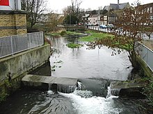
226:
234:
346:
208:
The river has been used since AD 762 to power various watermills along its route. These included eight corn mills and five paper mills. Buckland Mill near
Buckland Bridge was one of the earliest corn mills, but has since been converted into flats.
31:
245:). It follows the Dour from Temple Ewell to Wellington Dock on the seafront. The trail is about 4 miles (6 km) long and takes 2.5 hours to walk fully.
213:
is now a fully restored corn mill and museum, and the Old Mill in
Kearsney is now a private house, the others have been converted for various uses.
315:
289:
273:
201:, as a natural harbour for the Roman fleet. This silted up in the medieval period, necessitating the construction of various
225:
242:
186:
settlers and traders in the area. The remains of a Bronze Age seagoing boat (from 3,500 years ago), known as the
105:
216:
Other industries on the river included iron foundries, saw mills (demolished) and a tannery (also converted).
233:
350:
388:
378:
263:
187:
319:
383:
8:
269:
210:
293:
160:
219:
164:
372:
202:
120:
107:
191:
152:
140:
63:
156:
74:
183:
222:
and
Kearsney Abbey (a former Grand House) is also beside the River.
362:
179:
171:
148:
30:
345:
198:
175:
241:
The River Dour Trail is a new walking trail (set up by the
178:, although today it flows into the Dover Harbour through a
144:
356:
370:
197:The Dour Estuary was then used as a port for
159:between which is a neighbourhood served by a
261:
190:, were found in 1992, and it can be seen in
182:. The estuary was a natural harbour for the
167:. It is roughly 4 miles (6.4 km) long.
265:The English Coast: A History and a Prospect
255:
232:
224:
371:
308:
282:
13:
14:
400:
338:
344:
262:Peter Murphy (20 October 2011).
243:White Cliffs Countryside Project
151:. It flows from the villages of
29:
363:http://www.bucklandmill.co.uk/
1:
316:"River Dour Industrial Trail"
268:. A&C Black. p. 36.
248:
41:Physical characteristics
7:
229:River Dour in Alkham Valley
97:about 4 miles (6.4 km)
85: • location
59: • location
10:
405:
170:It originally had a wide
93:
83:
73:
69:
57:
49:
45:
40:
28:
23:
357:http://www.ccmt.org.uk/
35:River Dour within Dover
238:
230:
174:on the site of modern
16:River in Kent, England
236:
228:
188:Dover Bronze Age Boat
353:at Wikimedia Commons
121:51.12350°N 1.31440°E
322:on 16 February 2012
237:River Dour in Dover
205:for Dover instead.
203:artificial harbours
117: /
365:Buckland Mill page
239:
231:
359:Crabble Mill page
349:Media related to
275:978-1-4411-4514-7
143:in the county of
126:51.12350; 1.31440
101:
100:
396:
348:
332:
331:
329:
327:
318:. Archived from
312:
306:
305:
303:
301:
292:. Archived from
286:
280:
279:
259:
132:
131:
129:
128:
127:
122:
118:
115:
114:
113:
110:
60:
33:
21:
20:
404:
403:
399:
398:
397:
395:
394:
393:
369:
368:
341:
336:
335:
325:
323:
314:
313:
309:
299:
297:
288:
287:
283:
276:
260:
256:
251:
161:railway station
125:
123:
119:
116:
111:
108:
106:
104:
103:
86:
58:
36:
17:
12:
11:
5:
402:
392:
391:
389:Dover District
386:
381:
379:Rivers of Kent
367:
366:
360:
354:
340:
339:External links
337:
334:
333:
307:
296:on 19 May 2011
281:
274:
253:
252:
250:
247:
220:Kearsney, Kent
199:the Roman town
99:
98:
95:
91:
90:
87:
84:
81:
80:
77:
71:
70:
67:
66:
61:
55:
54:
51:
47:
46:
43:
42:
38:
37:
34:
26:
25:
15:
9:
6:
4:
3:
2:
401:
390:
387:
385:
382:
380:
377:
376:
374:
364:
361:
358:
355:
352:
347:
343:
342:
321:
317:
311:
295:
291:
285:
277:
271:
267:
266:
258:
254:
246:
244:
235:
227:
223:
221:
217:
214:
212:
206:
204:
200:
195:
193:
189:
185:
181:
177:
173:
168:
166:
162:
158:
154:
150:
146:
142:
138:
133:
130:
96:
92:
89:Dover Harbour
88:
82:
78:
76:
72:
68:
65:
62:
56:
52:
48:
44:
39:
32:
27:
22:
19:
324:. Retrieved
320:the original
310:
298:. Retrieved
294:the original
290:"River Dour"
284:
264:
257:
240:
218:
215:
211:Crabble Mill
207:
196:
192:Dover Museum
169:
153:Temple Ewell
141:chalk stream
136:
134:
102:
64:Temple Ewell
18:
384:Dover, Kent
124: /
373:Categories
351:River Dour
249:References
184:Bronze Age
137:River Dour
109:51°07′25″N
24:River Dour
112:1°18′52″E
300:11 March
165:Kearsney
180:culvert
172:estuary
149:England
326:18 May
272:
94:Length
79:
53:
50:Source
176:Dover
157:River
139:is a
75:Mouth
328:2011
302:2011
270:ISBN
155:and
145:Kent
135:The
375::
194:.
163:,
147:,
330:.
304:.
278:.
Text is available under the Creative Commons Attribution-ShareAlike License. Additional terms may apply.


