33:
210:
776:
180:
245:
501:
194:
252:
217:
436:
541:
surface measuring 5,382 by 200 feet (1,640 m × 61 m). The runway was resurfaced and realigned in August 2009; prior to this time, it was designated 15/33.
136:
1510:
713:
791:
955:
819:
429:
1064:
1505:
913:
651:
1381:
659:
460:
1102:
1236:
1201:
1117:
209:
1461:
1434:
1276:
1073:
581:
432:. Renton Airport has a floating dock and a launching ramp for conversion from wheeled landings to water takeoffs and landings.
1361:
1155:
682:
1402:
1057:
244:
1107:
1261:
1429:
1087:
906:
1231:
1097:
1050:
456:
394:
365:
69:
1301:
1241:
1226:
1013:
950:
839:
1346:
1122:
1484:
1412:
1296:
1127:
769:
173:
129:
1271:
1196:
899:
482:. US Customs service is available for both floatplane and wheeled aircraft arriving by water or by land.
72:
1371:
1221:
1256:
1132:
447:
airport which serves Renton and other nearby communities. It provides regional aviation services for
32:
1407:
1386:
1376:
1311:
1206:
978:
829:
825:
611:
607:
193:
851:
1356:
1306:
413:
1449:
1439:
1366:
945:
464:
119:
1474:
1469:
1336:
1251:
1092:
1024:
1003:
486:
424:
in 2005 to celebrate the 100th birthday of
Clayton Scott. The airport's northern boundary is
626:
1479:
1321:
1291:
652:"Appendix A: List of NPIAS Airports with 5-Year Forecast Activity and Development Estimate"
8:
1286:
1137:
397:
775:
179:
1417:
1341:
1281:
960:
922:
867:
409:
111:
1191:
557:
544:
In 2016, the airport had 122,908 aircraft operations, an average of 337 per day: 98%
386:
378:
58:
47:
500:
1326:
1211:
799:
739:
545:
534:
444:
871:
1351:
1170:
857:
805:
690:
615:. Federal Aviation Administration. effective May 23, 2019. Retrieved June 1, 2019
561:
504:
Aerial view showing airport and adjacent Boeing Renton
Factory (large structures)
497:, and is the initial point of departure for airplanes produced in that facility.
479:
425:
1444:
1216:
1147:
526:
468:
1499:
1422:
1331:
1246:
417:
151:
138:
877:
861:
786:
1316:
1112:
565:
627:"Clayton Scott, 1905–2006: Longtime aviator, Bill Boeing's personal pilot"
560:. In July 2017, there were 337 aircraft based at this airport: 243 single-
1266:
1175:
1160:
1042:
448:
569:
494:
490:
435:
295:
1018:
891:
845:
522:
455:, corporate, business and recreational flyers. It is included in the
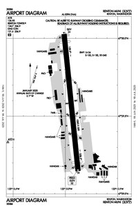
881:
740:"Runway repaving to ground most flights at Renton Municipal Airport"
474:
The airport is located approximately 12 miles southeast of downtown
549:
538:
452:
439:
View of brand new 737s being outfitted on the west side of Renton.
714:"737 problems have grown in Renton despite Boeing's reassurances"
553:
518:
475:
405:
530:
282:
795:
514:
811:
37:
Airport during a runway resurfacing project, August 2009
781:
443:
The airport is owned by the City of Renton and is a
663:. Federal Aviation Administration. October 3, 2018
1497:
683:"Renton Municipal Airport, Clayton Scott Field"
513:Renton Municipal Airport covers an area of 170
1511:Buildings and structures in Renton, Washington
1058:
907:
644:
430:Will Rogers–Wiley Post Memorial Seaplane Base
660:National Plan of Integrated Airport Systems
461:National Plan of Integrated Airport Systems
1072:
1065:
1051:
914:
900:
774:
508:
178:
499:
434:
16:Airport in King County, Washington State
737:
624:
1498:
921:
1046:
895:
711:
625:Wallace, James (September 29, 2006).
603:
601:
599:
597:
712:Gates, Dominic (September 6, 2018).
1506:Airports in King County, Washington
782:Boeing Employees Flying Association
13:
594:
485:Renton Airport is adjacent to the
14:
1522:
787:KRNT listing at FlightCentral.Net
761:
231:Location of airport in Washington
250:
243:
215:
208:
192:
31:
1430:NAS Whidbey Island (Ault Field)
866:NOAA/NWS weather observations:
820:FAA Terminal Procedures for RNT
738:Radford, Dean (July 30, 2009).
457:Federal Aviation Administration
366:Federal Aviation Administration
1014:Virginia Mason Athletic Center
731:
705:
675:
618:
582:List of airports in Washington
525:of 32 feet (9.8 m) above
463:for 2017–2021, in which it is
234:Show map of Washington (state)
1:
939:Primary and secondary schools
826:FAA Airport Form 5010 for RNT
822:, effective September 5, 2024
816:, effective September 5, 2024
608:FAA Airport Form 5010 for RNT
587:
272:Show map of the United States
956:Lindbergh Senior High School
846:airport information for KRNT
835:Resources for this airport:
792:Aerial image as of July 1990
7:
840:airport information for RNT
575:
251:
216:
10:
1527:
631:Seattle Post-Intelligencer
420:. The airport was renamed
343:Aircraft operations (2017)
1460:
1395:
1184:
1146:
1080:
1033:
996:
987:
971:
938:
929:
533:designated 16/34 with an
362:
350:
342:
338:
333:
302:
299:
294:
290:
281:
202:
191:
186:
167:
128:
117:
107:
99:
91:
86:
42:
30:
23:
1403:Air Station Port Angeles
1035:This list is incomplete.
1009:Renton Municipal Airport
979:Renton Technical College
852:accident history for RNT
671:– via www.faa.gov.
375:Renton Municipal Airport
25:Renton Municipal Airport
509:Facilities and aircraft
414:King County, Washington
1450:Vagabond Army Heliport
1440:Yakima Training Center
1272:Friday Harbor Seaplane
1161:Paine–Snohomish County
1074:Airports in Washington
946:Renton School District
505:
478:near the south end of
440:
152:47.49306°N 122.21583°W
124:32 ft / 10 m
1025:South Treatment Plant
1004:Boeing Renton Factory
564:, 13 multi-engine, 4
503:
487:Boeing Renton Factory
438:
351:Based aircraft (2017)
1362:Southwest Washington
1322:Orcas Island Airport
554:scheduled commercial
157:47.49306; -122.21583
882:Terminal Procedures
862:live flight tracker
858:airport information
806:FAA Airport Diagram
422:Clayton Scott Field
269:(the United States)
198:FAA airport diagram
148: /
1372:South Lewis County
1282:Kenmore Air Harbor
1227:Chehalis–Centralia
1113:King County–Boeing
961:Renton High School
923:Renton, Washington
878:aeronautical chart
506:
489:that manufactures
441:
404:) is a public use
112:Renton, Washington
1493:
1492:
1040:
1039:
951:Hazen High School
832:
718:The Seattle Times
614:
469:reliever facility
372:
371:
358:
357:
329:
328:
325:Asphalt/Concrete
1518:
1413:JB Lewis–McChord
1387:Wings for Christ
1277:Jefferson County
1067:
1060:
1053:
1044:
1043:
916:
909:
902:
893:
892:
828:
815:
800:The National Map
778:
773:
772:
770:Official website
755:
754:
752:
750:
735:
729:
728:
726:
724:
709:
703:
702:
700:
698:
693:on June 10, 2017
689:. Archived from
679:
673:
672:
670:
668:
656:
648:
642:
641:
639:
637:
622:
616:
610:
605:
546:general aviation
445:general aviation
340:
339:
292:
291:
285:
273:
254:
253:
247:
235:
219:
218:
212:
196:
182:
177:
176:
174:Official website
163:
162:
160:
159:
158:
153:
149:
146:
145:
144:
141:
79:
78:
65:
64:
54:
53:
35:
21:
20:
1526:
1525:
1521:
1520:
1519:
1517:
1516:
1515:
1496:
1495:
1494:
1489:
1456:
1435:NOLF Coupeville
1391:
1382:Port of Whitman
1307:Okanogan Legion
1180:
1142:
1076:
1071:
1041:
1036:
1029:
992:
983:
972:Other education
967:
934:
925:
920:
889:
872:past three days
809:
768:
767:
764:
759:
758:
748:
746:
744:Renton Reporter
736:
732:
722:
720:
710:
706:
696:
694:
681:
680:
676:
666:
664:
654:
650:
649:
645:
635:
633:
623:
619:
606:
595:
590:
578:
511:
480:Lake Washington
426:Lake Washington
368:
283:
277:
276:
275:
274:
271:
270:
264:
263:
262:
261:
255:
238:
237:
236:
233:
232:
229:
228:
227:
226:
220:
197:
172:
171:
156:
154:
150:
147:
142:
139:
137:
135:
134:
118:Elevation
82:
76:
68:
62:
57:
51:
46:
38:
26:
17:
12:
11:
5:
1524:
1514:
1513:
1508:
1491:
1490:
1488:
1487:
1485:Lake Wenatchee
1482:
1477:
1472:
1466:
1464:
1458:
1457:
1455:
1454:
1453:
1452:
1447:
1445:Selah Airstrip
1437:
1432:
1427:
1426:
1425:
1420:
1410:
1405:
1399:
1397:
1393:
1392:
1390:
1389:
1384:
1379:
1374:
1369:
1367:Tacoma Narrows
1364:
1359:
1354:
1349:
1344:
1339:
1334:
1329:
1324:
1319:
1314:
1309:
1304:
1299:
1294:
1289:
1284:
1279:
1274:
1269:
1264:
1259:
1254:
1249:
1244:
1239:
1234:
1232:Columbia Gorge
1229:
1224:
1219:
1214:
1209:
1204:
1199:
1194:
1188:
1186:
1182:
1181:
1179:
1178:
1173:
1168:
1163:
1158:
1152:
1150:
1144:
1143:
1141:
1140:
1135:
1130:
1125:
1120:
1118:Seattle–Tacoma
1115:
1110:
1108:Pullman–Moscow
1105:
1100:
1095:
1090:
1084:
1082:
1078:
1077:
1070:
1069:
1062:
1055:
1047:
1038:
1037:
1034:
1031:
1030:
1028:
1027:
1022:
1016:
1011:
1006:
1000:
998:
994:
993:
988:
985:
984:
982:
981:
975:
973:
969:
968:
966:
965:
964:
963:
958:
953:
942:
940:
936:
935:
930:
927:
926:
919:
918:
911:
904:
896:
887:
886:
885:
884:
874:
864:
854:
848:
842:
833:
823:
817:
803:
789:
784:
779:
763:
762:External links
760:
757:
756:
730:
704:
687:City of Renton
674:
643:
617:
592:
591:
589:
586:
585:
584:
577:
574:
527:mean sea level
510:
507:
467:as a regional
370:
369:
363:
360:
359:
356:
355:
352:
348:
347:
344:
336:
335:
331:
330:
327:
326:
323:
320:
317:
313:
312:
309:
305:
304:
301:
298:
288:
287:
279:
278:
265:
257:
256:
249:
248:
242:
241:
240:
239:
230:
222:
221:
214:
213:
207:
206:
205:
204:
203:
200:
199:
189:
188:
184:
183:
169:
165:
164:
132:
126:
125:
122:
115:
114:
109:
105:
104:
103:City of Renton
101:
97:
96:
93:
89:
88:
84:
83:
81:
80:
66:
55:
43:
40:
39:
36:
28:
27:
24:
15:
9:
6:
4:
3:
2:
1523:
1512:
1509:
1507:
1504:
1503:
1501:
1486:
1483:
1481:
1478:
1476:
1473:
1471:
1468:
1467:
1465:
1463:
1459:
1451:
1448:
1446:
1443:
1442:
1441:
1438:
1436:
1433:
1431:
1428:
1424:
1423:McChord Field
1421:
1419:
1416:
1415:
1414:
1411:
1409:
1408:Fairchild AFB
1406:
1404:
1401:
1400:
1398:
1394:
1388:
1385:
1383:
1380:
1378:
1375:
1373:
1370:
1368:
1365:
1363:
1360:
1358:
1355:
1353:
1350:
1348:
1345:
1343:
1340:
1338:
1337:Pierce County
1335:
1333:
1330:
1328:
1325:
1323:
1320:
1318:
1315:
1313:
1310:
1308:
1305:
1303:
1300:
1298:
1295:
1293:
1290:
1288:
1285:
1283:
1280:
1278:
1275:
1273:
1270:
1268:
1265:
1263:
1260:
1258:
1255:
1253:
1252:Dorothy Scott
1250:
1248:
1245:
1243:
1240:
1238:
1235:
1233:
1230:
1228:
1225:
1223:
1220:
1218:
1215:
1213:
1210:
1208:
1207:Avery–Laurier
1205:
1203:
1200:
1198:
1195:
1193:
1190:
1189:
1187:
1183:
1177:
1174:
1172:
1169:
1167:
1164:
1162:
1159:
1157:
1154:
1153:
1151:
1149:
1145:
1139:
1136:
1134:
1131:
1129:
1126:
1124:
1121:
1119:
1116:
1114:
1111:
1109:
1106:
1104:
1101:
1099:
1096:
1094:
1093:Friday Harbor
1091:
1089:
1086:
1085:
1083:
1079:
1075:
1068:
1063:
1061:
1056:
1054:
1049:
1048:
1045:
1032:
1026:
1023:
1020:
1017:
1015:
1012:
1010:
1007:
1005:
1002:
1001:
999:
995:
991:
986:
980:
977:
976:
974:
970:
962:
959:
957:
954:
952:
949:
948:
947:
944:
943:
941:
937:
933:
928:
924:
917:
912:
910:
905:
903:
898:
897:
894:
890:
883:
879:
875:
873:
869:
865:
863:
859:
855:
853:
849:
847:
843:
841:
837:
836:
834:
831:
827:
824:
821:
818:
813:
807:
804:
802:
801:
797:
793:
790:
788:
785:
783:
780:
777:
771:
766:
765:
745:
741:
734:
719:
715:
708:
692:
688:
684:
678:
662:
661:
653:
647:
632:
628:
621:
613:
609:
604:
602:
600:
598:
593:
583:
580:
579:
573:
571:
567:
563:
559:
556:, and <1%
555:
551:
547:
542:
540:
536:
532:
529:. It has one
528:
524:
520:
516:
502:
498:
496:
493:and formerly
492:
488:
483:
481:
477:
472:
470:
466:
462:
458:
454:
450:
446:
437:
433:
431:
427:
423:
419:
418:United States
415:
411:
407:
403:
399:
396:
392:
388:
384:
380:
376:
367:
361:
353:
349:
345:
341:
337:
332:
324:
321:
318:
315:
314:
310:
307:
306:
297:
293:
289:
286:
280:
268:
260:
246:
225:
211:
201:
195:
190:
185:
181:
175:
170:
166:
161:
133:
131:
127:
123:
121:
116:
113:
110:
106:
102:
98:
94:
90:
85:
74:
71:
67:
60:
56:
49:
45:
44:
41:
34:
29:
22:
19:
1302:Ocean Shores
1292:Lopez Island
1262:Grant County
1166:Renton–Scott
1165:
1008:
989:
931:
888:
856:FlightAware
798:
747:. Retrieved
743:
733:
721:. Retrieved
717:
707:
695:. Retrieved
691:the original
686:
677:
665:. Retrieved
658:
646:
634:. Retrieved
630:
620:
543:
512:
484:
473:
442:
421:
412:, a city in
401:
390:
382:
374:
373:
266:
258:
223:
92:Airport type
18:
1462:State-owned
1287:Lake Chelan
1128:Walla Walla
465:categorized
449:air charter
408:located in
155: /
143:122°12′57″W
130:Coordinates
1500:Categories
1342:Quillayute
1297:Moses Lake
1098:Tri-Cities
1088:Bellingham
876:SkyVector
697:January 4,
588:References
570:helicopter
334:Statistics
140:47°29′35″N
1352:Sanderson
1242:Deer Park
1237:Davenport
1222:Bremerton
1202:Arlington
1192:Anacortes
1103:Fairchild
1021:(defunct)
1019:Longacres
997:Landmarks
932:Education
552:, <1%
523:elevation
517:(69
296:Direction
1418:Gray AAF
1396:Military
1347:Richland
1327:Packwood
1212:Bowerman
1197:Anderson
1133:Pangborn
576:See also
568:, and 8
558:military
550:air taxi
539:concrete
521:) at an
453:air taxi
428:and the
364:Source:
303:Surface
1475:Copalis
1470:Bandera
1332:Pearson
1312:Olympia
1257:Ephrata
1247:Dickson
1185:General
1123:Spokane
1081:Primary
868:current
844:AirNav
749:June 1,
723:June 1,
667:June 1,
636:June 1,
535:asphalt
476:Seattle
406:airport
346:122,908
300:Length
284:Runways
168:Website
87:Summary
1480:Easton
1377:Vashon
1357:Skagit
1217:Bowers
1171:Harvey
1156:Auburn
1148:Relief
1138:Yakima
808:
562:engine
531:runway
459:(FAA)
410:Renton
322:1,640
319:5,382
316:16/34
108:Serves
95:Public
1267:Grove
1176:Felts
990:Other
794:from
655:(PDF)
548:, 1%
515:acres
100:Owner
1317:Omak
860:and
850:ASN
838:FAA
796:USGS
751:2019
725:2019
699:2016
669:2019
638:2019
537:and
495:757s
491:737s
391:KRNT
387:ICAO
379:IATA
187:Maps
120:AMSL
63:KRNT
59:ICAO
48:IATA
830:PDF
812:PDF
612:PDF
566:jet
402:RNT
398:LID
395:FAA
383:RNT
354:250
308:ft
267:RNT
259:RNT
224:RNT
77:RNT
73:LID
70:FAA
52:RNT
1502::
880:,
870:,
742:.
716:.
685:.
657:.
629:.
596:^
572:.
519:ha
471:.
451:,
416:,
400::
393:,
389::
385:,
381::
311:m
75::
61::
50::
1066:e
1059:t
1052:v
915:e
908:t
901:v
814:)
810:(
753:.
727:.
701:.
640:.
377:(
Text is available under the Creative Commons Attribution-ShareAlike License. Additional terms may apply.