54:
593:
42:
396:
327:
As of the census of 2000, there were 1,592 people, 588 households, and 415 families residing in the CDP. The population density was 1,165.8 inhabitants per square mile (450.1/km). There were 630 housing units at an average density of 461.3 per square mile (178.1/km). The racial makeup of the CDP
375:
In the CDP, the population was spread out, with 29.8% under the age of 18, 9.2% from 18 to 24, 31.3% from 25 to 44, 19.3% from 45 to 64, and 10.4% who were 65 years of age or older. The median age was 33 years. For every 100 females, there were 95.8 males. For every 100 females age 18 and over,
379:
The median income for a household in the CDP was $ 33,652, and the median income for a family was $ 35,592. Males had a median income of $ 24,219 versus $ 21,250 for females. The per capita income for the CDP was $ 14,664. About 11.2% of families and 15.5% of the population were below the
367:
with no husband present, and 29.3% were non-families. 23.5% of all households were made up of individuals, and 7.7% had someone living alone who was 65 years of age or older. The average household was 2.71 person, and the average
53:
428:
984:
296:
319:, the CDP has a total area of 1.4 square miles (3.7 km), of which 1.4 square miles (3.5 km) is land, and 0.077 square miles (0.2 km) (5.07%) is water.
994:
817:
521:
70:
832:
1009:
363:
There were 588 households, out of which 38.9% had children under the age of 18 living with them, 41.8% were married couples living together, 22.4% had a
284:
1014:
304:
999:
514:
1004:
711:
603:
564:
752:
429:"Profile of General Population and Housing Characteristics: 2020 Demographic Profile Data (DP-1): Poquonock Bridge CDP, Connecticut"
499:
507:
910:
724:
381:
989:
827:
300:
41:
762:
531:
345:
333:
277:
123:
59:
416:
867:
747:
666:
337:
979:
926:
807:
852:
482:
457:
432:
349:
316:
288:
949:
792:
572:
916:
877:
767:
882:
872:
857:
837:
757:
719:
529:
238:
892:
787:
734:
691:
616:
577:
553:
454:"Geographic Identifiers: 2010 Demographic Profile Data (G001): Poquonock Bridge CDP, Connecticut"
269:
32:
887:
797:
701:
696:
661:
621:
353:
671:
631:
626:
292:
956:
847:
777:
686:
676:
646:
641:
582:
357:
213:
8:
772:
742:
651:
636:
611:
341:
329:
273:
133:
902:
782:
681:
401:
842:
656:
973:
921:
364:
85:
72:
417:
U.S. Geological Survey
Geographic Names Information System: Poquonock Bridge
384:, including 23.5% of those under age 18, and 5.4% of those age 65 or over.
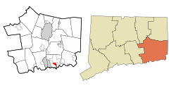
280:, Connecticut, United States. The population was 1,686 at the 2020 census.
940:‡This populated place also has portions in an adjacent county or counties
862:
546:
369:
113:
220:
203:
198:
985:
Census-designated places in New London County, Connecticut
478:
453:
18:
391:
283:
The village is located just east of the head of the
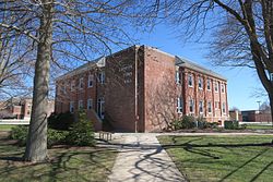
307:. The Groton Town Hall is located in the village.
995:Connecticut placenames of Native American origin
971:
295:. The village was first settled in 1652–53 by
515:
1010:Villages in New London County, Connecticut
522:
508:
421:
360:of any race were 6.16% of the population.
1015:Census-designated places in Connecticut
972:
503:
1000:Populated places established in 1652
927:Paucatuck Eastern Pequot reservation
410:
352:, and 6.53% from two or more races.
164:0.077 sq mi (0.2 km)
13:
1005:1652 establishments in Connecticut
911:Golden Hill Paugussett reservation
591:
530:Municipalities and communities of
471:
14:
1026:
156:1.4 sq mi (3.5 km)
148:1.4 sq mi (3.7 km)
394:
52:
40:
917:Mashantucket Pequot reservation
322:
533:New London County, Connecticut
446:
60:New London County, Connecticut
1:
387:
753:Conning Towers-Nautilus Park
310:
7:
483:United States Census Bureau
458:United States Census Bureau
433:United States Census Bureau
317:United States Census Bureau
10:
1031:
945:
935:
901:
816:
733:
710:
602:
589:
563:
544:
287:near the intersection of
255:
247:
237:
227:
210:
197:
193:1,200/sq mi (470/km)
189:
181:
176:
168:
160:
152:
144:
139:
129:
119:
109:
101:
66:
51:
39:
30:
23:
990:Villages in Connecticut
376:there were 91.4 males.
270:census-designated place
33:Census-designated place
596:
172:98 ft (30 m)
595:
479:"U.S. Census website"
293:Connecticut Route 117
272:(CDP) in the town of
212: • Summer (
86:41.34500°N 72.02472°W
958:United States portal
190: • Density
980:Groton, Connecticut
922:Mohegan reservation
903:Indian reservations
91:41.34500; -72.02472
82: /
951:Connecticut portal
597:
402:Connecticut portal
365:female householder
182: • Total
161: • Water
145: • Total
967:
966:
843:Groton Long Point
315:According to the
278:New London County
268:is a village and
263:
262:
153: • Land
1022:
959:
952:
828:Burnett's Corner
803:Poquonock Bridge
667:North Stonington
594:
556:
549:
539:
534:
524:
517:
510:
501:
500:
494:
493:
491:
489:
475:
469:
468:
466:
464:
450:
444:
443:
441:
439:
425:
419:
414:
404:
399:
398:
397:
346:Pacific Islander
334:African American
285:Poquonnock River
266:Poquonock Bridge
217:
97:
96:
94:
93:
92:
87:
83:
80:
79:
78:
75:
56:
46:Groton Town Hall
44:
25:Poquonock Bridge
21:
20:
1030:
1029:
1025:
1024:
1023:
1021:
1020:
1019:
970:
969:
968:
963:
957:
950:
941:
931:
897:
819:
812:
729:
706:
598:
592:
587:
559:
554:
547:
540:
537:
532:
528:
498:
497:
487:
485:
477:
476:
472:
462:
460:
452:
451:
447:
437:
435:
427:
426:
422:
415:
411:
400:
395:
393:
390:
338:Native American
325:
313:
256:GNIS feature ID
233:
211:
206:(Eastern (EST))
90:
88:
84:
81:
76:
73:
71:
69:
68:
62:
47:
35:
26:
19:
12:
11:
5:
1028:
1018:
1017:
1012:
1007:
1002:
997:
992:
987:
982:
965:
964:
962:
961:
954:
946:
943:
942:
939:
937:
933:
932:
930:
929:
924:
919:
914:
907:
905:
899:
898:
896:
895:
890:
885:
880:
875:
870:
865:
860:
855:
850:
845:
840:
835:
830:
824:
822:
814:
813:
811:
810:
805:
800:
795:
790:
785:
780:
775:
770:
765:
760:
755:
750:
745:
739:
737:
731:
730:
728:
727:
722:
716:
714:
708:
707:
705:
704:
699:
694:
689:
684:
679:
674:
669:
664:
659:
654:
649:
644:
639:
634:
629:
624:
619:
614:
608:
606:
600:
599:
590:
588:
586:
585:
580:
575:
569:
567:
561:
560:
545:
542:
541:
527:
526:
519:
512:
504:
496:
495:
470:
445:
420:
408:
407:
406:
405:
389:
386:
324:
321:
312:
309:
305:Nehemiah Smith
261:
260:
257:
253:
252:
249:
245:
244:
241:
235:
234:
231:
229:
225:
224:
218:
208:
207:
201:
195:
194:
191:
187:
186:
183:
179:
178:
174:
173:
170:
166:
165:
162:
158:
157:
154:
150:
149:
146:
142:
141:
137:
136:
131:
127:
126:
121:
117:
116:
111:
107:
106:
103:
99:
98:
64:
63:
57:
49:
48:
45:
37:
36:
31:
28:
27:
24:
17:
9:
6:
4:
3:
2:
1027:
1016:
1013:
1011:
1008:
1006:
1003:
1001:
998:
996:
993:
991:
988:
986:
983:
981:
978:
977:
975:
960:
955:
953:
948:
947:
944:
938:
934:
928:
925:
923:
920:
918:
915:
912:
909:
908:
906:
904:
900:
894:
891:
889:
886:
884:
881:
879:
876:
874:
871:
869:
866:
864:
861:
859:
856:
854:
851:
849:
846:
844:
841:
839:
836:
834:
831:
829:
826:
825:
823:
821:
815:
809:
806:
804:
801:
799:
796:
794:
793:Oxoboxo River
791:
789:
786:
784:
781:
779:
776:
774:
771:
769:
766:
764:
761:
759:
756:
754:
751:
749:
746:
744:
741:
740:
738:
736:
732:
726:
723:
721:
718:
717:
715:
713:
709:
703:
700:
698:
695:
693:
690:
688:
685:
683:
680:
678:
675:
673:
670:
668:
665:
663:
660:
658:
655:
653:
650:
648:
645:
643:
640:
638:
635:
633:
630:
628:
625:
623:
620:
618:
615:
613:
610:
609:
607:
605:
601:
584:
581:
579:
576:
574:
571:
570:
568:
566:
562:
558:
557:
550:
543:
538:United States
535:
525:
520:
518:
513:
511:
506:
505:
502:
484:
480:
474:
459:
455:
449:
434:
430:
424:
418:
413:
409:
403:
392:
385:
383:
377:
373:
371:
366:
361:
359:
355:
351:
348:, 1.76% from
347:
343:
339:
335:
331:
320:
318:
308:
306:
302:
298:
294:
290:
286:
281:
279:
275:
271:
267:
258:
254:
250:
246:
242:
240:
236:
230:
226:
222:
219:
215:
209:
205:
202:
200:
196:
192:
188:
184:
180:
175:
171:
167:
163:
159:
155:
151:
147:
143:
138:
135:
132:
128:
125:
122:
118:
115:
112:
108:
105:United States
104:
100:
95:
67:Coordinates:
65:
61:
55:
50:
43:
38:
34:
29:
22:
16:
878:Preston City
833:Graniteville
802:
768:Mashantucket
552:
486:. Retrieved
473:
461:. Retrieved
448:
436:. Retrieved
423:
412:
382:poverty line
378:
374:
362:
326:
323:Demographics
314:
297:James Morgan
289:U.S. Route 1
282:
265:
264:
58:Location in
15:
883:Quaker Hill
873:Poquetanuck
868:Oswegatchie
863:Norwichtown
858:Lords Point
838:Greeneville
820:communities
758:Gales Ferry
720:Jewett City
548:County seat
488:January 31,
463:October 29,
370:family size
350:other races
328:was 65.45%
301:James Avery
114:Connecticut
89: /
974:Categories
893:Uncasville
788:Old Mystic
748:Colchester
725:Stonington
692:Stonington
617:Colchester
578:New London
555:New London
388:References
372:was 3.14.
177:Population
124:New London
77:72°01′29″W
74:41°20′42″N
936:Footnotes
888:Taftville
808:Waterford
798:Pawcatuck
763:Long Hill
702:Waterford
697:Voluntown
662:Montville
622:East Lyme
332:, 14.13%
311:Geography
248:FIPS code
239:Area code
199:Time zone
169:Elevation
712:Boroughs
672:Old Lyme
632:Griswold
627:Franklin
354:Hispanic
344:, 0.25%
340:, 8.04%
336:, 3.83%
251:09-61730
228:ZIP code
848:Hanover
778:Niantic
687:Sprague
677:Preston
647:Ledyard
642:Lebanon
583:Norwich
438:June 7,
259:2377852
102:Country
853:Jordan
773:Mystic
743:Baltic
652:Lisbon
637:Groton
612:Bozrah
573:Groton
565:Cities
358:Latino
303:, and
274:Groton
134:Groton
120:County
818:Other
783:Noank
682:Salem
604:Towns
342:Asian
330:White
232:06340
223:(EDT)
221:UTC−4
204:UTC−5
185:1,727
110:State
735:CDPs
657:Lyme
490:2008
465:2012
440:2023
291:and
140:Area
130:Town
356:or
276:in
243:860
214:DST
976::
551::
536:,
481:.
456:.
431:.
299:,
913:‡
523:e
516:t
509:v
492:.
467:.
442:.
216:)
Text is available under the Creative Commons Attribution-ShareAlike License. Additional terms may apply.

