52:
162:
issued a statement saying in part "It is fitting that the easternmost point of the United States, in the Virgin
Islands, and the westernmost point, in Guam, are both named 'Udall Point.' The Sun will never set on the legacy of Mo Udall." This was also noted in the
128:, proposed renaming the point "to honor the service and accomplishments of Morris Udall." While the proposed resolution was referred to the House Subcommittee on Insular and International Affairs, the name was officially designated as Point Udall by
67:
98:
139:
97:
which forms the northern coast of the harbor. Many sources still call it Orote Point, such as the US Military's Orote Point Lanes bowling alley. The
259:
272:"Congressional Record - Proceedings and Debates of the 106th Congress, First Session - House of Representatives (Vol. 145, No. 34)"
120:. It was called Orote Point until it was renamed Point Udall in May 1987. Earlier that month, H.R. 2434, tabled by U.S. Congressman
21:
168:
234:
180:
143:
271:
75:
323:
154:. In a 1987 statement in regards to H.R. 2434, Congressman Smith and Guam's nonvoting congressional delegate
158:
explained that "America's day would begin and end at a Point Udall." When Mo Udall died in 1998, President
318:
129:
328:
101:
303:
220:
164:
55:
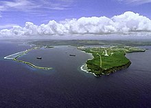
Point Udall (Orote Point) is the headland on the right in this view of Apra Harbor's mouth
8:
132:
204:
239:
82:
147:
312:
151:
94:
78:
36:
23:
185:
159:
121:
90:
71:
155:
117:
93:, on the end of Orote Peninsula, opposite the Glass Breakwater of
113:
125:
51:
86:
304:
Congressional resolution designating Udall Point, Guam
260:Weekly compilation of Presidential documents, 1998
310:
233:Tolchin, Martin; Binder, David (1989-02-17).
232:
216:
214:
212:
209:
50:
311:
150:, had been named for Udall's brother,
181:Extreme points of the United States
13:
16:Point on the Orote Peninsula, Guam
14:
340:
297:
66:, is the westernmost point (by
264:
253:
226:
223:from the University of Arizona
198:
112:The point is named for former
1:
281:. March 4, 1999. p. H982
191:
7:
174:
10:
345:
89:. It lies at the mouth of
107:
104:is located at the point.
102:Orote Historical Complex
37:13.447556°N 144.618194°E
235:"The Pillars of Udall"
221:Bill text and articles
205:MWR bowling alley site
142:in the United States,
56:
54:
42:13.447556; 144.618194
324:Headlands of Oceania
165:Congressional Record
133:Joseph Franklin Ada
33: /
240:The New York Times
135:later that month.
57:
319:Landforms of Guam
140:easternmost point
118:Morris "Mo" Udall
81:, located on the
336:
291:
290:
288:
286:
276:
268:
262:
257:
251:
250:
248:
247:
230:
224:
218:
207:
202:
130:Governor of Guam
48:
47:
45:
44:
43:
38:
34:
31:
30:
29:
26:
344:
343:
339:
338:
337:
335:
334:
333:
329:Orote Peninsula
309:
308:
300:
295:
294:
284:
282:
274:
270:
269:
265:
258:
254:
245:
243:
231:
227:
219:
210:
203:
199:
194:
177:
171:of California.
110:
83:Orote Peninsula
41:
39:
35:
32:
27:
24:
22:
20:
19:
17:
12:
11:
5:
342:
332:
331:
326:
321:
307:
306:
299:
298:External links
296:
293:
292:
263:
252:
225:
208:
196:
195:
193:
190:
189:
188:
183:
176:
173:
148:Virgin Islands
109:
106:
62:, also called
15:
9:
6:
4:
3:
2:
341:
330:
327:
325:
322:
320:
317:
316:
314:
305:
302:
301:
280:
273:
267:
261:
256:
242:
241:
236:
229:
222:
217:
215:
213:
206:
201:
197:
187:
184:
182:
179:
178:
172:
170:
169:George Miller
166:
161:
157:
153:
149:
145:
141:
138:In 1968, the
136:
134:
131:
127:
123:
119:
115:
105:
103:
100:
96:
95:Cabras Island
92:
88:
84:
80:
79:United States
77:
73:
69:
65:
61:
53:
49:
46:
283:. Retrieved
278:
266:
255:
244:. Retrieved
238:
228:
200:
186:Udall family
160:Bill Clinton
137:
116:congressman
111:
63:
59:
58:
28:144°37′5.5″E
25:13°26′51.2″N
18:
279:govinfo.gov
144:Point Udall
122:Denny Smith
99:NRHP-listed
91:Apra Harbor
76:territorial
64:Orote Point
60:Point Udall
40: /
313:Categories
246:2018-10-12
192:References
285:March 13,
74:) in the
72:longitude
175:See also
167:by Rep.
156:Ben Blaz
152:Stewart
114:Arizona
126:Oregon
108:Naming
70:, not
68:travel
275:(PDF)
287:2021
87:Guam
124:of
85:of
315::
277:.
237:.
211:^
146:,
289:.
249:.
Text is available under the Creative Commons Attribution-ShareAlike License. Additional terms may apply.
