271:
232:
218:
299:
257:
316:
678:
285:
49:
690:
607:(October 20, 1818) was a land swap, exchanging British possessions south of the new 49th parallel boundary for US possessions that extended north of the border. After a border survey in 1823, the Hudson's Bay Company could not continue to assume that Pembina stood on British soil and moved into southern Canada.
642:
When
Minnesota became a state in 1858 the area became unorganized again. A provisional government was set up that lobbied for territory status. The main reason to organize the area was to induce settlement with a more localized government. After the Dakota Territory was organized there was still a
643:
move for more local territorial control because of the distance to the territorial capital. Factions were attempting this in different areas of the territory. South Dakota introduced legislation, with the support of the
Committee on Territories, for the creation of the
658:(1876), there was a proposal to separate the western half into the "Territory of Lincoln" and the eastern half as the Dakota Territory. In February 1872 the Senate Committee on Territories reviewed a bill to create the Pembina Territory with the capital at
634:
in the
Minnesota Territorial legislature. Rolette is renowned for subverting passage of a bill proposing to divide Minnesota Territory along an east-west line, which would have moved the State capital to
488:. When Minnesota became a state on May 11, 1858, and its western boundary was set at the Red River, the western part of the Pembina region again became unorganized territory. Organization of
615:
In 1834, the
Pembina District became part of the Michigan Territory, and was subsequently assigned to Wisconsin and Iowa Territories. For a brief period after the admission of the States of
750:
623:(May 29, 1848), some or all of the region reverted to unorganized status. Establishment of Minnesota Territory on March 3, 1849 was followed by organization of
878:
551:
600:
set up peaceful international arbitration. Indian treaties further open land to expansion and this was the beginning of the seeking of territorial status.
438:
to the United States from the
British. Settlements south of the boundary continued to be de facto administered as part of Assiniboia until at least 1823.
873:
574:
did not clearly set northern United States/Canadian boundaries. According to the treaty the boundary line was to leave the
Northwesternmost point of the
379:
237:
31:
893:
883:
834:
888:
403:
515:(1803) included almost all of current South Dakota, the southern half and some of the north-central part of Minnesota, that became the
813:
666:
as the capital. A final solution was found on
November 2, 1889, when both North and South Dakota became separate states.
543:
495:
The portion of the historic
Pembina region not incorporated into the State of Minnesota was apportioned to the States of
596:(April 16, 1818) was a treaty of disarmament and peaceful negotiations creating a demilitarized boundary. The following
754:
362:
520:
446:
532:
472:
The region was considered unorganized territory from 1818 until June 28, 1834, when
Congress assigned it to the
677:
787:
597:
775:
898:
648:
644:
624:
399:
457:. Prior to 1823, the Pembina settlement was believed by both countries to be within the boundary of
465:
799:
470:
a country about 400 miles from north to south and more than five hundred miles from east to west.
415:
703:
571:
427:
65:
663:
593:
559:
516:
458:
454:
450:
442:
17:
636:
546:
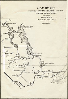
acquired controlling interest in the HBC and received 116,000 square miles of land in the
464:
Several attempts at formal recognition and naming failed to pass
Congress. In 1849 Father
8:
555:
485:
481:
435:
708:
547:
512:
473:
419:
223:
492:
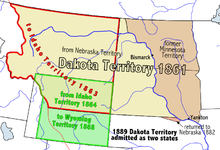
on March 2, 1861 marked the final establishment of organized territorial government.
579:
575:
542:
land grant, because the land was under a monopoly of the Hudson's Bay Company (HBC),
264:
445:
made surveys during the 1823 expedition to the Red River of the North and placed an
511:
Several events shaped the area of the Pembina Region within the United States. The
489:
423:
407:
330:
315:
589:
250:
728:
604:
539:
477:
431:
115:
867:
849:
836:
411:
383:
60:
35:
659:
528:
500:
496:
441:
The area was referred to as the Pembina District after the U.S. Army Major
395:
391:
292:
278:
172:
168:
655:
631:
585:
468:
described the area, referred to as Pembina district or department, as
689:
620:
387:
386:
in 1818. The area included the portions of what became the States of
48:
751:"The History and Culture of the Turtle Mountain Band of Chippewa"
790:; State Historical Society of North Dakota- Retrieved 2014-12-26
554:, and extended south to the watershed of the Red River near the
550:
of 1811. The area of land within the grant became known as the
524:
147:• unorganized Territory (after Missouri became a state)
811:
588:(1796) boundaries issues were still unresolved in 1801. The
616:
354:
339:
453:
clearly defining the border between the United States and
348:
639:, and left Pembina once again in unorganized territory.
476:. Subsequently, the region was successively a part of
503:
on their admission to the Union of November 2, 1889.
363:
351:
578:(the current boundary) "on a due West Course to the
345:
336:
342:
333:
865:
627:, encompassing the historic Pembina settlement.
816:. S. J. Clarke publishing Company. p. 1612
406:area. The region was formerly part of British
82:Unorganized unincorporated Territory or Region
879:States and territories disestablished in 1889
805:
662:, and Dakota (present-day South Dakota) with
654:In 1868, after the discovery of gold in the
434:de jure transferred the region south of the
729:"Pembina State Museum - The Pembina Region"
535:, that was a mixture of French and Indian.
874:States and territories established in 1818
731:. State Historical Society of North Dakota
47:
314:
127:• US/British boundary change to US
814:"History of Dakota Territory, Volume 2"
402:. The area included settlements in the
866:
753:. North Dakota Studies. Archived from
426:in 1812, the area was governed as the
422:and establishment of the agricultural
894:Pre-statehood history of South Dakota
884:Pre-statehood history of North Dakota
812:Kingsbury, George Washington (1915).
610:
538:After trying unsuccessfully to get a
519:. The area was populated mostly with
544:Thomas Douglas, 5th Earl of Selkirk
13:
889:Pre-statehood history of Minnesota
14:
910:
688:
676:
329:
297:
283:
269:
255:
230:
216:
137:• To Territory of Missouri
104:• Former British Territory
582:" which is much farther south.
793:
781:
769:
743:
721:
382:of land that was ceded to the
1:
714:
378:, is the historic name of an
7:
788:territory of Assiniboia map
697:
630:Pembina was represented by
598:Treaty of Washington (1871)
565:
558:. The current community of
370:), also referred to as the
10:
915:
669:
506:
15:
400:Hudson Bay drainage basin
195:
191:
187:
183:
165:
157:• Dakota Territotry
155:
145:
135:
125:
112:
102:
98:
90:
86:
76:
72:
56:
46:
41:
30:
25:
619:(December 28, 1846) and
466:Georges-Antoine Belcourt
16:Not to be confused with
802:- Retrieved 2014-12-26
778:- Retrieved 2014-12-26
704:Treaty of Old Crossing
572:Treaty of Paris (1783)
447:International boundary
428:District of Assiniboia
320:
562:was within the area.
517:District of Louisiana
459:British North America
455:British North America
443:Stephen Harriman Long
410:, granted by British
380:unorganized territory
318:
238:Unorganized territory
32:Unorganized territory
18:Pembina Valley Region
776:Ossiniboia Territory
552:Assiniboia Territory
416:Hudson's Bay Company
114:• Created from
846: /
757:on 18 November 2015
556:45th parallel north
486:Minnesota Territory
482:Wisconsin Territory
800:US/Canada boundary
709:Red River ox carts
683:Territorial growth
611:Territorial Status
548:Selkirk Concession
513:Louisiana Purchase
474:Michigan Territory
420:Selkirk Concession
376:Pembina Department
321:
224:Nebraska Territory
850:48.333°N 97.833°W
594:Rush–Bagot Treaty
592:(1814-1815). The
580:river Mississippi
576:Lake of the Woods
398:lying within the
313:
312:
309:
308:
305:
304:
265:Wyoming Territory
243:
242:
78: • Type
906:
861:
860:
858:
857:
856:
851:
847:
844:
843:
842:
839:
826:
825:
823:
821:
809:
803:
797:
791:
785:
779:
773:
767:
766:
764:
762:
747:
741:
740:
738:
736:
725:
692:
680:
490:Dakota Territory
449:marker north of
424:Red River Colony
372:Pembina District
366:
361:
360:
357:
356:
353:
350:
347:
344:
341:
338:
335:
301:
300:
287:
286:
273:
272:
259:
258:
247:
246:
234:
233:
220:
219:
213:
212:
197:
196:
141:October 20, 1818
108:October 19, 1818
79:
51:
23:
22:
914:
913:
909:
908:
907:
905:
904:
903:
864:
863:
855:48.333; -97.833
854:
852:
848:
845:
840:
837:
835:
833:
832:
830:
829:
819:
817:
810:
806:
798:
794:
786:
782:
774:
770:
760:
758:
749:
748:
744:
734:
732:
727:
726:
722:
717:
700:
693:
684:
681:
672:
613:
590:Treaty of Ghent
568:
509:
364:
332:
328:
298:
284:
270:
256:
251:Idaho Territory
231:
217:
179:2 November 1889
176:
158:
151:August 10, 1821
148:
138:
128:
118:
105:
77:
64:
52:
21:
12:
11:
5:
912:
902:
901:
896:
891:
886:
881:
876:
828:
827:
804:
792:
780:
768:
742:
719:
718:
716:
713:
712:
711:
706:
699:
696:
695:
694:
687:
685:
682:
675:
671:
668:
625:Pembina County
612:
609:
605:Treaty of 1818
567:
564:
508:
505:
484:, and finally
478:Iowa Territory
432:Treaty of 1818
325:Pembina Region
311:
310:
307:
306:
303:
302:
295:
289:
288:
281:
275:
274:
267:
261:
260:
253:
244:
241:
240:
235:
227:
226:
221:
209:
208:
203:
193:
192:
189:
188:
185:
184:
181:
180:
177:
166:
163:
162:
159:
156:
153:
152:
149:
146:
143:
142:
139:
136:
133:
132:
129:
126:
123:
122:
119:
116:Treaty of 1818
113:
110:
109:
106:
103:
100:
99:
96:
95:
92:
88:
87:
84:
83:
80:
74:
73:
70:
69:
58:
54:
53:
44:
43:
39:
38:
28:
27:
26:Pembina Region
9:
6:
4:
3:
2:
911:
900:
899:Rupert's Land
897:
895:
892:
890:
887:
885:
882:
880:
877:
875:
872:
871:
869:
862:
859:
815:
808:
801:
796:
789:
784:
777:
772:
756:
752:
746:
730:
724:
720:
710:
707:
705:
702:
701:
691:
686:
679:
674:
673:
667:
665:
661:
657:
652:
651:Territories.
650:
646:
640:
638:
633:
628:
626:
622:
618:
608:
606:
601:
599:
595:
591:
587:
583:
581:
577:
573:
563:
561:
557:
553:
549:
545:
541:
536:
534:
530:
526:
522:
518:
514:
504:
502:
498:
493:
491:
487:
483:
479:
475:
471:
467:
462:
460:
456:
452:
448:
444:
439:
437:
436:49th parallel
433:
429:
425:
421:
417:
413:
412:royal charter
409:
408:Rupert's Land
405:
404:Pembina River
401:
397:
393:
389:
385:
384:United States
381:
377:
373:
369:
368:
359:
326:
317:
296:
294:
291:
290:
282:
280:
277:
276:
268:
266:
263:
262:
254:
252:
249:
248:
245:
239:
236:
229:
228:
225:
222:
215:
214:
211:
210:
207:
204:
202:
199:
198:
194:
190:
186:
182:
178:
174:
170:
164:
161:March 2, 1861
160:
154:
150:
144:
140:
134:
130:
124:
120:
117:
111:
107:
101:
97:
93:
89:
85:
81:
75:
71:
67:
62:
61:Washington DC
59:
55:
50:
45:
40:
37:
36:United States
33:
29:
24:
19:
831:
818:. Retrieved
807:
795:
783:
771:
759:. Retrieved
755:the original
745:
733:. Retrieved
723:
653:
641:
629:
614:
602:
584:
569:
537:
529:fur trappers
510:
501:South Dakota
494:
469:
463:
440:
418:. After the
396:South Dakota
392:North Dakota
375:
371:
324:
322:
293:South Dakota
279:North Dakota
206:Succeeded by
205:
200:
173:South Dakota
169:North Dakota
853: /
656:Black Hills
632:Joe Rolette
201:Preceded by
68:(1883–1889)
63:(1818–1849)
868:Categories
820:October 4,
715:References
649:East River
586:Jay Treaty
319:Assiniboia
175:statehood
761:3 October
735:3 October
637:St. Peter
621:Wisconsin
388:Minnesota
42:1818–1889
698:See also
660:Bismarck
566:Treaties
521:Chippewa
66:Bismarck
841:97°50′W
838:48°20′N
670:Gallery
664:Yankton
560:Pembina
540:British
507:History
451:Pembina
414:to the
167:•
91:History
57:Capital
531:, and
525:Ojibwe
430:. The
394:, and
367:-bi-nə
94:
533:Métis
497:North
822:2015
763:2015
737:2015
647:and
645:West
617:Iowa
603:The
570:The
499:and
374:and
323:The
171:and
131:1818
121:1818
527:),
365:PEM
34:of
870::
480:,
461:.
390:,
824:.
765:.
739:.
523:(
358:/
355:ə
352:n
349:ɪ
346:b
343:m
340:ɛ
337:p
334:ˈ
331:/
327:(
20:.
Text is available under the Creative Commons Attribution-ShareAlike License. Additional terms may apply.

