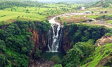
301:. On 17 July 2011, heavy rains occurred in the catchment area upstream of the waterfall. Over 50 visitors, many of them on a picnic, were sitting near the waterfall at that time. The local villagers warned them about the risk, and asked them to move away from water. Most of the visitors managed to get to safety, but five people were not able to move away in time. However, as they were crossing the stream, they were washed away in a sudden gush of water. Only two of them survived. The bodies of the victims were found over the next week: Chavi Dhoot of 22 years (18 July), Chandrashekhar Rathi of 55 years (19 July) and His daughter Mudita Rathi of 22 years (20 July). A video of the accident went viral. Subsequently, the local administration constructed a bridge and a staircase to avoid similar mishaps.
29:
108:
100:
170:
The water flow is highest immediately after the rainy season (usually after July). It goes almost dry in the summer season, and the stream is reduced to a trickle. The area around
Patalpani is a popular
387:
442:
268:
and the rail line itself which more than a century old. It returns back the same day to Dr. Ambedkar Nagar (MHOW) from
Kalakund in the evening.
221:
which is situated at a distance of roughly 40 km from the falls. The rest of the distance has to be covered via road or rail transport means.
376:
318:
365:
437:
398:
254:
246:
238:
344:
280:
town in Indore
District. From there, the waterfall is situated at a distance of 8 km on internal country roads.
234:
250:
258:
242:
8:
245:
metre gauge train line. Two trains run on these route, one being the
Heritage Train from
140:
47:
294:
218:
160:
144:
112:
51:
431:
413:
400:
132:
265:
164:
128:
111:
PatalPani
Waterfall, a magnificent fall situated around 35 KM from Indore,
91:
62:
298:
194:
28:
107:
99:
264:
The heritage train offers views of the Ghats, the
Valleys, the
189:
172:
163:. It has an approximate height of 91 m (300 ft). It is on the
206:
148:
116:
55:
377:
MP: Body of girl swept away at
Patalpani waterfall recovered
277:
222:
136:
43:
366:
Five swept away in floods at
Patalpani waterfall in Indore
276:
To reach the waterfall via road, one has to first reach
197:
in Indian mythology). Therefore, the falls are called
319:"52965/Dr. Ambedkar Nagar - Kalakund Heritage Train"
429:
237:near the falls at a distance of 200 m on the
187:) at the bottom of the falls goes as deep as
388:2011 tragedy still fresh in people's mind
255:Dr. Ambedkar Nagar Railway Station (MHOW)
247:Dr. Ambedkar Nagar Railway Station (MHOW)
239:Dr. Ambedkar Nagar Railway Station (MHOW)
345:"Tourists will get Hot Food in Kalakund"
106:
98:
297:(July-September), the area is prone to
443:Tourist attractions in Indore district
430:
342:
13:
14:
454:
347:(in Hindi). Mhow, Indore: Patrika
288:
183:According to folklore, the pit (
27:
233:The nearest railway station is
381:
370:
359:
336:
311:
1:
343:Rajak, Sanjay (12 Sep 2021).
304:
438:Waterfalls of Madhya Pradesh
283:
253:and the local train between
219:Indore International Airport
178:
159:Patalpani is a waterfall in
154:
7:
212:
10:
459:
278:Dr. Ambedkar Nagar (MHOW)
235:Patalpani railway station
223:Dr. Ambedkar Nagar (MHOW)
87:
79:
75:91.5 metres (300 ft)
71:
61:
39:
35:
26:
21:
271:
228:
217:The nearest airport is
127:is a waterfall on the
120:
104:
323:indiarailinfo(dot)com
225:is the nearest town.
131:, a tributary of the
110:
102:
103:Patalpani waterfall.
414:22.5039°N 75.7987°E
410: /
175:and trekking spot.
125:Patalpani Waterfall
121:
105:
16:Waterfall in India
143:in the state of
135:, located in the
97:
96:
450:
425:
424:
422:
421:
420:
419:22.5039; 75.7987
415:
411:
408:
407:
406:
403:
390:
385:
379:
374:
368:
363:
357:
356:
354:
352:
340:
334:
333:
331:
329:
315:
209:word for water.
31:
19:
18:
458:
457:
453:
452:
451:
449:
448:
447:
428:
427:
418:
416:
412:
409:
404:
401:
399:
397:
396:
394:
393:
386:
382:
375:
371:
364:
360:
350:
348:
341:
337:
327:
325:
317:
316:
312:
307:
291:
286:
274:
231:
215:
181:
157:
141:Indore district
80:Number of drops
48:Indore district
22:Patalpani Falls
17:
12:
11:
5:
456:
446:
445:
440:
392:
391:
380:
369:
358:
335:
309:
308:
306:
303:
295:monsoon season
290:
289:Deaths in 2011
287:
285:
282:
273:
270:
230:
227:
214:
211:
180:
177:
161:Madhya Pradesh
156:
153:
145:Madhya Pradesh
113:Madhya Pradesh
95:
94:
89:
85:
84:
81:
77:
76:
73:
69:
68:
65:
59:
58:
52:Madhya Pradesh
41:
37:
36:
33:
32:
24:
23:
15:
9:
6:
4:
3:
2:
455:
444:
441:
439:
436:
435:
433:
426:
423:
389:
384:
378:
373:
367:
362:
346:
339:
324:
320:
314:
310:
302:
300:
296:
281:
279:
269:
267:
262:
260:
256:
252:
248:
244:
240:
236:
226:
224:
220:
210:
208:
204:
200:
196:
192:
191:
186:
176:
174:
168:
166:
162:
152:
150:
146:
142:
138:
134:
130:
126:
118:
114:
109:
101:
93:
90:
86:
82:
78:
74:
70:
66:
64:
60:
57:
53:
49:
45:
42:
38:
34:
30:
25:
20:
395:
383:
372:
361:
349:. Retrieved
338:
326:. Retrieved
322:
313:
299:flash floods
292:
275:
266:Choral River
263:
232:
216:
202:
198:
188:
184:
182:
169:
165:Choral River
158:
129:Choral River
124:
122:
119:. July 2013.
92:Choral River
72:Total height
417: /
293:During the
88:Watercourse
432:Categories
405:75°47′55″E
402:22°30′14″N
351:26 October
328:26 October
305:References
205:being the
199:Patal-pani
195:underworld
139:Tehsil of
284:Accidents
179:Etymology
155:The falls
67:segmented
251:Kalakund
213:Location
40:Location
259:Sanawad
243:Sanawad
133:Narmada
173:picnic
249:till
207:Hindi
193:(the
190:patal
149:India
117:India
56:India
353:2021
330:2021
272:Road
257:and
229:Rail
203:pani
185:kund
137:Mhow
123:The
63:Type
44:Mhow
167:.
434::
321:.
261:.
201:,
151:.
147:,
115:,
54:,
50:,
46:,
355:.
332:.
241:-
83:1
Text is available under the Creative Commons Attribution-ShareAlike License. Additional terms may apply.


