45:
168:
322:
311:
290:
29:
299:
52:
394:
321:
325:
401:
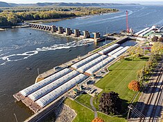
256:. It was constructed and was put into operation by April 1937. The site then underwent major rehabilitation from 1989 through 2003. The lock and dam are owned and operated by the
701:
706:
756:
751:
359:
434:
342:
454:
387:
326:
https://web.archive.org/web/20161226221158/http://www.mvr.usace.army.mil/Portals/48/docs/CC/FactSheets/MISS/UMR%20Locks%20%26%20Dams%20-%202016%20%28MVD%29.pdf
424:
410:
726:
721:
369:
429:
459:
283:, 938 feet (285.9 m) long and 1,338 feet (407.8 m) long. The lock is 110 feet (33.5 m) wide by 600 feet (182.9 m) long.
95:
44:
741:
261:
746:
691:
364:
337:
354:
310:
171:
766:
761:
265:
379:
716:
711:
635:
79:
75:
696:
444:
242:
187:
71:
230:
736:
257:
167:
731:
298:
8:
641:
630:
625:
620:
615:
610:
605:
600:
595:
590:
585:
580:
575:
570:
565:
560:
535:
505:
500:
668:
659:
555:
545:
540:
530:
525:
520:
515:
510:
374:
Upper
Mississippi River 9-Foot Channel, Lock & Dam No. 8, Genoa, Vernon County, WI
464:
238:
484:
279:. The earth embankment is 17,500 feet (5,334.0 m) long with two submersible
271:
The dam consists of a concrete structure 934 feet (284.7 m) long with five
215:
685:
479:
469:
253:
110:
97:
83:
449:
276:
474:
439:
409:
245:
373:
360:
U.S. Army Corps of
Engineers, St. Paul District: Lock and Dam 8 brochure
289:
272:
249:
28:
280:
376:", 120 photos, 10 data pages, 9 photo caption pages
355:
U.S. Army Corps of
Engineers, St. Paul District: Lock and Dam 8
343:
Upper
Mississippi River National Wildlife and Fish Refuge
234:
702:
Buildings and structures in
Houston County, Minnesota
411:
707:
Buildings and structures in Vernon County, Wisconsin
757:Historic American Engineering Record in Wisconsin
752:Historic American Engineering Record in Minnesota
683:
395:
59:Location of Lock and Dam No. 8 in Wisconsin
727:Transport infrastructure completed in 1937
722:United States Army Corps of Engineers dams
402:
388:
51:
220:64,770 sq mi (167,800 km)
684:
383:
338:Public Works Administration dams list
262:United States Army Corps of Engineers
370:Historic American Engineering Record
210:260,000 acre⋅ft (0.32 km)
33:Mississippi River Lock & Dam #8
13:
320:
14:
778:
348:
309:
297:
288:
166:
50:
43:
27:
16:Dam in Minnesota, United States
1:
742:Dams on the Mississippi River
638:(Melvin Price Locks and Dam)
172:U.S. Army Corps of Engineers
7:
747:Mississippi Valley Division
331:
266:Mississippi Valley Division
150:; 87 years ago
132:; 91 years ago
10:
783:
651:
506:Lower Saint Anthony Falls
501:Upper Saint Anthony Falls
493:
417:
214:
206:
198:
193:
183:
178:
162:
144:
126:
89:
80:Houston County, Minnesota
67:
38:
26:
21:
372:(HAER) No. WI-49, "
316:Lock and dam 8 spill way
76:Vernon County, Wisconsin
692:Mississippi River locks
445:Winnibigoshish Lake Dam
435:Ottertail Power Co. Dam
188:Upper Mississippi River
127:Construction began
328:
644:(Chain of Rocks Lock)
455:Blandin Paper Co. Dam
324:
111:43.57000°N 91.23167°W
365:USGS Reach 1, Pool 8
425:Stepping Stones Dam
216:Catchment area
207:Total capacity
174:, St. Paul District
116:43.57000; -91.23167
107: /
767:Locks of Wisconsin
762:Locks of Minnesota
669:Lock and Dam No. 9
660:Lock and Dam No. 7
329:
304:Lock and Dam No. 8
227:Lock and Dam No. 8
22:Lock and Dam No. 8
717:Dams in Wisconsin
712:Dams in Minnesota
679:
678:
674:
673:
224:
223:
179:Dam and spillways
145:Opening date
774:
654:
653:
465:Little Falls Dam
404:
397:
390:
381:
380:
313:
301:
292:
260:District of the
239:Genoa, Wisconsin
170:
158:
156:
151:
140:
138:
133:
122:
121:
119:
118:
117:
112:
108:
105:
104:
103:
100:
54:
53:
47:
31:
19:
18:
782:
781:
777:
776:
775:
773:
772:
771:
682:
681:
680:
675:
667:
658:
647:
489:
485:Coon Rapids Dam
413:
408:
351:
334:
317:
314:
305:
302:
293:
154:
152:
149:
136:
134:
131:
115:
113:
109:
106:
101:
98:
96:
94:
93:
63:
62:
61:
60:
57:
56:
55:
34:
17:
12:
11:
5:
780:
770:
769:
764:
759:
754:
749:
744:
739:
734:
729:
724:
719:
714:
709:
704:
699:
697:Driftless Area
694:
677:
676:
672:
671:
664:
662:
652:
649:
648:
646:
645:
639:
633:
628:
623:
618:
613:
608:
603:
598:
593:
588:
583:
578:
573:
568:
563:
558:
553:
548:
543:
538:
533:
528:
523:
518:
513:
508:
503:
497:
495:
494:Locks and dams
491:
490:
488:
487:
482:
477:
472:
467:
462:
457:
452:
447:
442:
437:
432:
427:
421:
419:
415:
414:
407:
406:
399:
392:
384:
378:
377:
367:
362:
357:
350:
349:External links
347:
346:
345:
340:
333:
330:
319:
318:
315:
308:
306:
303:
296:
294:
287:
222:
221:
218:
212:
211:
208:
204:
203:
200:
196:
195:
191:
190:
185:
181:
180:
176:
175:
164:
160:
159:
146:
142:
141:
128:
124:
123:
91:
87:
86:
69:
65:
64:
58:
49:
48:
42:
41:
40:
39:
36:
35:
32:
24:
23:
15:
9:
6:
4:
3:
2:
779:
768:
765:
763:
760:
758:
755:
753:
750:
748:
745:
743:
740:
738:
735:
733:
730:
728:
725:
723:
720:
718:
715:
713:
710:
708:
705:
703:
700:
698:
695:
693:
690:
689:
687:
670:
665:
663:
661:
656:
655:
650:
643:
640:
637:
634:
632:
629:
627:
624:
622:
619:
617:
614:
612:
609:
607:
604:
602:
599:
597:
594:
592:
589:
587:
584:
582:
579:
577:
574:
572:
569:
567:
564:
562:
559:
557:
554:
552:
549:
547:
544:
542:
539:
537:
534:
532:
529:
527:
524:
522:
519:
517:
514:
512:
509:
507:
504:
502:
499:
498:
496:
492:
486:
483:
481:
480:St. Cloud Dam
478:
476:
473:
471:
470:Blanchard Dam
468:
466:
463:
461:
458:
456:
453:
451:
448:
446:
443:
441:
438:
436:
433:
431:
428:
426:
423:
422:
420:
416:
412:
405:
400:
398:
393:
391:
386:
385:
382:
375:
371:
368:
366:
363:
361:
358:
356:
353:
352:
344:
341:
339:
336:
335:
327:
323:
312:
307:
300:
295:
291:
286:
285:
284:
282:
278:
277:tainter gates
274:
269:
267:
263:
259:
255:
254:United States
252:679.2 in the
251:
247:
244:
240:
237:located near
236:
232:
228:
219:
217:
213:
209:
205:
201:
197:
192:
189:
186:
182:
177:
173:
169:
165:
161:
147:
143:
129:
125:
120:
92:
88:
85:
84:United States
81:
77:
73:
70:
66:
46:
37:
30:
25:
20:
737:Gravity dams
550:
460:Potlatch Dam
450:Pokegama Dam
273:roller gates
270:
226:
225:
732:Roller dams
666:Downstream:
475:Sartell Dam
440:Knutson Dam
430:Vekin's Dam
248:River near
246:Mississippi
163:Operator(s)
114: /
90:Coordinates
686:Categories
250:river mile
148:April 1937
102:91°13′54″W
99:43°34′12″N
657:Upstream:
281:spillways
194:Reservoir
332:See also
258:St. Paul
184:Impounds
68:Location
275:and 10
241:on the
199:Creates
153: (
135: (
202:Pool 8
243:Upper
229:is a
72:Genoa
418:Dams
233:and
231:lock
155:1937
137:1933
130:1933
235:dam
688::
642:27
636:26
631:25
626:24
621:22
616:21
611:20
606:19
601:18
596:17
591:16
586:15
581:14
576:13
571:12
566:11
561:10
536:5A
268:.
82:,
78:/
74:,
556:9
551:8
546:7
541:6
531:5
526:4
521:3
516:2
511:1
403:e
396:t
389:v
264:-
157:)
139:)
Text is available under the Creative Commons Attribution-ShareAlike License. Additional terms may apply.


