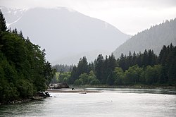
45:
565:
29:
52:
310:
The term "the
Kitlope" may refer also to the basin of the Kitlope, including the basins of its tributaries. The area has been the scene of protracted conservationist vs. resource extraction controversy since the 1970s and is now the
512:
625:
606:
44:
345:
373:
363:
296:
599:
204:
635:
630:
479:
404:
592:
420:
139:
323:
312:
276:
414:
264:
448:
409:
8:
580:
498:
Length measured using Google Maps path tool, BCGNIS coordinates, topographic maps, and
292:
483:
443:
299:, and means "people of the rocks" or "people of the opening in the mountains". The
572:
288:
86:
300:
125:
576:
564:
260:
113:
537:
619:
387:
381:
335:
284:
280:
272:
219:
206:
190:
154:
141:
368:
355:
185:
316:
271:, flowing north for 100 km (62 mi), into the head of the
380:
in Haisla; the
Tenaiko is a tributary to the Gamsby - note also
28:
268:
76:
499:
463:
538:"Huchsduwachsdu Nuyem Jees / Kitlope Heritage Conservancy"
617:
626:Rivers of the North Coast of British Columbia
600:
342:in Haisla) - joins the Kitlope at its estuary
295:reference to the people, who call themselves
474:
472:
352:in Haisla) - joins the Kitlope via the Tezwa
486:, BCGNIS coordinates, and topographic maps.
462:Derived using BCGNIS, topographic maps and
607:
593:
469:
494:
492:
438:
436:
279:. It is named for the Gitlope group of
618:
489:
433:
51:
571:This article related to a river in
559:
480:ASTER Global Digital Elevation Model
405:Khutzeymateen Grizzly Bear Sanctuary
275:to the south of the smelter town of
505:
362:in Haisla) - joins the Kitlope via
13:
421:List of rivers of British Columbia
14:
647:
513:"Canadian 1:50K topographic maps"
326:is located at the river's mouth.
16:River in British Columbia, Canada
563:
50:
43:
27:
265:North Coast of British Columbia
530:
456:
329:
315:, a protected area managed by
198: • coordinates
133: • coordinates
1:
426:
324:Kitlope Indian Reserve No. 16
291:near Kitimat. The name is a
101:Physical characteristics
636:British Columbia river stubs
631:Rivers of the Kitimat Ranges
579:. You can help Knowledge by
313:Kitlope Heritage Conservancy
287:government and community at
237: • elevation
172: • elevation
7:
398:
121: • location
10:
652:
558:
176:693 m (2,274 ft)
245:
235:
196:
184:
180:
170:
131:
119:
109:
105:
100:
92:
82:
72:
67:
38:
26:
21:
249:100 km (62 mi)
478:Elevation derived from
241:40 m (130 ft)
303:name for the river is
220:53.25028°N 127.89306°W
155:52.72556°N 127.57611°W
59:Mouth of Kitlope River
449:BC Geographical Names
410:Great Bear Rainforest
225:53.25028; -127.89306
160:52.72556; -127.57611
216: /
151: /
96:Coast Land District
293:Tsimshian language
283:, now part of the
259:is a river in the
588:
587:
253:
252:
33:The Kitlope River
643:
609:
602:
595:
573:British Columbia
567:
560:
550:
549:
547:
545:
534:
528:
527:
525:
523:
517:
509:
503:
496:
487:
476:
467:
460:
454:
453:
440:
417:(disambiguation)
289:Kitamaat Village
231:
230:
228:
227:
226:
221:
217:
214:
213:
212:
209:
173:
166:
165:
163:
162:
161:
156:
152:
149:
148:
147:
144:
134:
122:
87:British Columbia
54:
53:
47:
31:
19:
18:
651:
650:
646:
645:
644:
642:
641:
640:
616:
615:
614:
613:
556:
554:
553:
543:
541:
536:
535:
531:
521:
519:
518:. TopoQuest.com
515:
511:
510:
506:
497:
490:
477:
470:
461:
457:
444:"Kitlope River"
442:
441:
434:
429:
401:
332:
301:Haisla language
238:
224:
222:
218:
215:
210:
207:
205:
203:
202:
199:
171:
159:
157:
153:
150:
145:
142:
140:
138:
137:
132:
126:Coast Mountains
120:
63:
62:
61:
60:
57:
56:
55:
34:
17:
12:
11:
5:
649:
639:
638:
633:
628:
612:
611:
604:
597:
589:
586:
585:
575:, Canada is a
568:
552:
551:
529:
504:
488:
468:
455:
431:
430:
428:
425:
424:
423:
418:
412:
407:
400:
397:
396:
395:
385:
371:
366:
353:
343:
331:
328:
261:Kitimat Ranges
251:
250:
247:
243:
242:
239:
236:
233:
232:
200:
197:
194:
193:
188:
182:
181:
178:
177:
174:
168:
167:
135:
129:
128:
123:
117:
116:
114:Kitimat Ranges
111:
107:
106:
103:
102:
98:
97:
94:
90:
89:
84:
80:
79:
74:
70:
69:
65:
64:
58:
49:
48:
42:
41:
40:
39:
36:
35:
32:
24:
23:
15:
9:
6:
4:
3:
2:
648:
637:
634:
632:
629:
627:
624:
623:
621:
610:
605:
603:
598:
596:
591:
590:
584:
582:
578:
574:
569:
566:
562:
561:
557:
539:
533:
514:
508:
501:
495:
493:
485:
481:
475:
473:
465:
459:
451:
450:
445:
439:
437:
432:
422:
419:
416:
413:
411:
408:
406:
403:
402:
393:
389:
388:Kapella River
386:
383:
382:Tenaiko Range
379:
375:
372:
370:
367:
365:
361:
357:
354:
351:
347:
346:Kalitan Creek
344:
341:
337:
336:Tsaytis River
334:
333:
327:
325:
320:
318:
314:
308:
306:
302:
298:
294:
290:
286:
285:Haisla Nation
282:
278:
274:
273:Gardner Canal
270:
266:
262:
258:
257:Kitlope River
248:
244:
240:
234:
229:
201:
195:
192:
191:Gardner Canal
189:
187:
183:
179:
175:
169:
164:
136:
130:
127:
124:
118:
115:
112:
108:
104:
99:
95:
91:
88:
85:
81:
78:
75:
71:
66:
46:
37:
30:
25:
22:Kitlope River
20:
581:expanding it
570:
555:
542:. Retrieved
532:
520:. Retrieved
507:
458:
447:
391:
377:
374:Tnaiko Creek
369:Gamsby River
364:Kitlope Lake
359:
349:
339:
321:
309:
305:Xesduwaxwsdu
304:
256:
254:
356:Tezwa River
330:Tributaries
223: /
211:127°53′35″W
158: /
146:127°34′34″W
620:Categories
540:. BC Parks
484:GeoLocator
427:References
394:in Haisla)
297:Henaksiala
143:52°43′32″N
500:TopoQuest
464:TopoQuest
392:Qapela'ax
208:53°15′1″N
544:4 August
522:4 August
482:, using
399:See also
350:Tlasudis
317:BC Parks
93:District
83:Province
68:Location
415:Kitlope
360:Wa'yuwa
277:Kitimat
263:in the
73:Country
378:Daniko
340:C'itis
281:Haisla
269:Canada
246:Length
110:Source
77:Canada
516:(map)
186:Mouth
577:stub
546:2021
524:2021
322:The
255:The
622::
491:^
471:^
446:.
435:^
319:.
307:.
267:,
608:e
601:t
594:v
583:.
548:.
526:.
502:.
466:.
452:.
390:(
384:)
376:(
358:(
348:(
338:(
Text is available under the Creative Commons Attribution-ShareAlike License. Additional terms may apply.

