258:
242:
40:
250:
673:
91:
421:
593:
346:
The 1991 national census put the district population at about 140,950. In 2002, the national census estimated the population at 212,220, with an estimated annual growth rate of 3 percent. In 2012, the population was estimated at 300,800.
322:, which is constitutionally recognized but non-functional as of May 2011. The sub-region was home to an estimated population of 10,577,900 million as of 2020, according to the national census conducted that year.
382:
Milk and meat are important products of the district. In 2006, it was estimated that the district produced more than 100,000 liters of milk daily. The produce is sold locally and also marketed to
392:, a subsidiary of Amos Dairies Limited, is setting up a milk-processing plant at Akageti in Kiruhura District, with the capacity to process more than 2 million litres of milk annually.
634:
639:
661:
53:
355:
Kiruhura
District is a farming district. Livestock forms the backbone of economic activity in the district. The animals raised include:
606:
257:
569:
517:
654:
39:
1447:
302:
to the north-west. The district headquarters are approximately 65 kilometres (40 mi), by road, northeast of
669:
1442:
647:
389:
334:
is in
Rwakitura, Nyabushozi County, in Kiruhura District. The Rwakitura home functions like an upcountry
1432:
253:
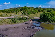
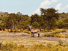
Lake Mburo
National Park is a national park located in Nyabushozi County, Kiruhura District in Uganda.
386:, Uganda's capital and largest city about 240 kilometres (150 mi) to the east of the district.
190:
1030:
468:
1233:
1163:
832:
689:
547:
227:
108:
492:
318:
The district is part of the larger Ankole sub-region. That sub-region is coterminous with the
702:
1336:
935:
910:
807:
335:
241:
8:
1346:
1256:
1251:
985:
752:
677:
401:
223:
115:
30:
1401:
1158:
990:
980:
930:
875:
817:
772:
722:
707:
283:
279:
1406:
1391:
1381:
1356:
1351:
1301:
1296:
1286:
1276:
1261:
1058:
1053:
1043:
885:
802:
737:
681:
307:
291:
275:
271:
120:
103:
1386:
1376:
1371:
1366:
1361:
1326:
1321:
1306:
1246:
1241:
1208:
1143:
1098:
1093:
1010:
1000:
965:
940:
895:
865:
860:
792:
782:
762:
757:
742:
732:
727:
295:
182:
1437:
1411:
1396:
1341:
1311:
1291:
1281:
1271:
1213:
1183:
1148:
1123:
1118:
1108:
1103:
1083:
1063:
1020:
1015:
1005:
970:
945:
925:
920:
915:
900:
890:
855:
850:
845:
840:
822:
797:
777:
767:
747:
712:
697:
331:
299:
443:
1266:
1223:
1218:
1203:
1193:
1188:
1178:
1173:
1168:
1128:
1068:
1048:
995:
975:
960:
955:
905:
880:
870:
812:
787:
717:
287:
1426:
1316:
1198:
1153:
1133:
1113:
1088:
1078:
1073:
1038:
950:
359:
68:
55:
493:"Western (Region, Uganda) - Population Statistics, Charts, Map and Location"
573:
525:
261:
Lake Mburo
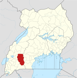
National Park is located in Kiruhura District in Western Uganda.
127:
1138:
610:
521:
373:
173:
548:"Estimated Population of Kiruhura District In 1991, 2002 & 2012"
235:
132:
249:
383:
303:
672:
319:
231:
178:
96:
310:. The coordinates of the district are:-0.2101960, 30.8390492.
204:
378:
Hybrid goats - mixtures of Boer goats and
African goats
469:"Uganda Population 2022 (Demographics, Maps, Graphs)"
422:"Map Showing Mbarara And Kiruhura With stance Marker"
367:
Hybrid cattle - mixtures of exotic and Ankole breeds
607:"Uganda Targets 20 Billion Litres of Milk Annually"
330:The country home of the current Uganda President
1424:
594:Distance between Kiruhura and Kampala with Map
655:
635:Location of Kiruhura District At Google Maps
662:
648:
238:is the site of the district headquarters.
256:
248:
240:
1425:
604:
570:"Milk production in Kiruhura District"
515:
350:
643:
518:"Museveni Meets Mumbere In Rwakitura"
147:4,605 km (1,778 sq mi)
313:
516:Vision, Reporter (5 January 2010).
13:
16:District in Western Region, Uganda
14:
1459:
628:
270:Kiruhura District is bordered by
671:
605:Vision, Reporter (13 May 2014).
338:when the president is visiting.
245:Kanyaryeru in Kiruhura District.
89:
38:
598:
587:
562:
540:
509:
485:
461:
436:
414:
1:
444:"Node: Kiruhura (3233732148)"
407:
341:
7:
395:
390:Amos Dairies Uganda Limited
325:
265:
44:District location in Uganda
10:
1464:
306:, the largest town in the
1232:
1029:
831:
688:
473:worldpopulationreview.com
199:
189:
172:
164:
156:
151:
143:
138:
126:
114:
102:
84:
49:
37:
28:
21:
168:65.3/km (169/sq mi)
1448:Western Region, Uganda
298:to the south-west and
262:
254:
246:
497:www.citypopulation.de
260:
252:
244:
364:Exotic cattle breeds
165: • Density
1443:Districts of Uganda
678:Districts of Uganda
550:. Citypopulation.de
402:Districts of Uganda
351:Economic activities
290:to the south-east,
282:to the north-east,
65: /
284:Lyantonde District
280:Sembabule District
263:
255:
247:
157: • Total
1433:Kiruhura District
1420:
1419:
450:. 2 February 2016
314:Ankole sub-region
308:Ankole sub-region
292:Isingiro District
276:Kyegegwa District
272:Kamwenge District
220:Kiruhura District
217:
216:
144: • Land
121:Ankole sub-region
23:Kiruhura District
1455:
676:
675:
664:
657:
650:
641:
640:
622:
621:
619:
617:
602:
596:
591:
585:
584:
582:
581:
572:. Archived from
566:
560:
559:
557:
555:
544:
538:
537:
535:
533:
524:. Archived from
513:
507:
506:
504:
503:
489:
483:
482:
480:
479:
465:
459:
458:
456:
455:
440:
434:
433:
431:
429:
418:
296:Mbarara District
213:
210:
208:
206:
95:
93:
92:
80:
79:
77:
76:
75:
70:
69:0.200°S 31.000°E
66:
63:
62:
61:
58:
42:
19:
18:
1463:
1462:
1458:
1457:
1456:
1454:
1453:
1452:
1423:
1422:
1421:
1416:
1228:
1025:
827:
684:
670:
668:
631:
626:
625:
615:
613:
603:
599:
592:
588:
579:
577:
568:
567:
563:
553:
551:
546:
545:
541:
531:
529:
514:
510:
501:
499:
491:
490:
486:
477:
475:
467:
466:
462:
453:
451:
442:
441:
437:
427:
425:
424:. Globefeed.com
420:
419:
415:
410:
398:
353:
344:
332:Yoweri Museveni
328:
316:
300:Ibanda District
268:
203:
90:
88:
73:
71:
67:
64:
59:
56:
54:
52:
51:
45:
33:
24:
17:
12:
11:
5:
1461:
1451:
1450:
1445:
1440:
1435:
1418:
1417:
1415:
1414:
1409:
1404:
1399:
1394:
1389:
1384:
1379:
1374:
1369:
1364:
1359:
1354:
1349:
1344:
1339:
1334:
1329:
1324:
1319:
1314:
1309:
1304:
1299:
1294:
1289:
1284:
1279:
1274:
1269:
1264:
1259:
1254:
1249:
1244:
1238:
1236:
1230:
1229:
1227:
1226:
1221:
1216:
1211:
1206:
1201:
1196:
1191:
1186:
1181:
1176:
1171:
1166:
1161:
1156:
1151:
1146:
1141:
1136:
1131:
1126:
1121:
1116:
1111:
1106:
1101:
1096:
1091:
1086:
1081:
1076:
1071:
1066:
1061:
1056:
1051:
1046:
1041:
1035:
1033:
1027:
1026:
1024:
1023:
1018:
1013:
1008:
1003:
998:
993:
988:
983:
978:
973:
968:
963:
958:
953:
948:
943:
938:
933:
928:
923:
918:
913:
908:
903:
898:
893:
888:
883:
878:
873:
868:
863:
858:
853:
848:
843:
837:
835:
829:
828:
826:
825:
820:
815:
810:
805:
800:
795:
790:
785:
780:
775:
770:
765:
760:
755:
750:
745:
740:
735:
730:
725:
720:
715:
710:
705:
700:
694:
692:
686:
685:
667:
666:
659:
652:
644:
638:
637:
630:
629:External links
627:
624:
623:
597:
586:
561:
539:
528:on 14 May 2014
508:
484:
460:
435:
412:
411:
409:
406:
405:
404:
397:
394:
380:
379:
376:
371:
368:
365:
362:
352:
349:
343:
340:
327:
324:
320:Ankole Kingdom
315:
312:
294:to the south,
288:Rakai District
278:to the north,
267:
264:
234:. The town of
228:Western Region
215:
214:
201:
197:
196:
193:
187:
186:
176:
170:
169:
166:
162:
161:
158:
154:
153:
149:
148:
145:
141:
140:
136:
135:
130:
124:
123:
118:
112:
111:
109:Western Region
106:
100:
99:
86:
82:
81:
74:-0.200; 31.000
47:
46:
43:
35:
34:
29:
26:
25:
22:
15:
9:
6:
4:
3:
2:
1460:
1449:
1446:
1444:
1441:
1439:
1436:
1434:
1431:
1430:
1428:
1413:
1410:
1408:
1405:
1403:
1400:
1398:
1395:
1393:
1390:
1388:
1385:
1383:
1380:
1378:
1375:
1373:
1370:
1368:
1365:
1363:
1360:
1358:
1355:
1353:
1350:
1348:
1345:
1343:
1340:
1338:
1335:
1333:
1330:
1328:
1325:
1323:
1320:
1318:
1315:
1313:
1310:
1308:
1305:
1303:
1300:
1298:
1295:
1293:
1290:
1288:
1285:
1283:
1280:
1278:
1275:
1273:
1270:
1268:
1265:
1263:
1260:
1258:
1255:
1253:
1250:
1248:
1245:
1243:
1240:
1239:
1237:
1235:
1231:
1225:
1222:
1220:
1217:
1215:
1212:
1210:
1207:
1205:
1202:
1200:
1197:
1195:
1192:
1190:
1187:
1185:
1182:
1180:
1177:
1175:
1172:
1170:
1167:
1165:
1164:Nakapiripirit
1162:
1160:
1157:
1155:
1152:
1150:
1147:
1145:
1142:
1140:
1137:
1135:
1132:
1130:
1127:
1125:
1122:
1120:
1117:
1115:
1112:
1110:
1107:
1105:
1102:
1100:
1097:
1095:
1092:
1090:
1087:
1085:
1082:
1080:
1077:
1075:
1072:
1070:
1067:
1065:
1062:
1060:
1057:
1055:
1052:
1050:
1047:
1045:
1042:
1040:
1037:
1036:
1034:
1032:
1028:
1022:
1019:
1017:
1014:
1012:
1009:
1007:
1004:
1002:
999:
997:
994:
992:
989:
987:
984:
982:
979:
977:
974:
972:
969:
967:
964:
962:
959:
957:
954:
952:
949:
947:
944:
942:
939:
937:
934:
932:
929:
927:
924:
922:
919:
917:
914:
912:
909:
907:
904:
902:
899:
897:
894:
892:
889:
887:
884:
882:
879:
877:
874:
872:
869:
867:
864:
862:
859:
857:
854:
852:
849:
847:
844:
842:
839:
838:
836:
834:
830:
824:
821:
819:
816:
814:
811:
809:
806:
804:
801:
799:
796:
794:
791:
789:
786:
784:
781:
779:
776:
774:
771:
769:
766:
764:
761:
759:
756:
754:
751:
749:
746:
744:
741:
739:
736:
734:
731:
729:
726:
724:
721:
719:
716:
714:
711:
709:
706:
704:
701:
699:
696:
695:
693:
691:
687:
683:
679:
674:
665:
660:
658:
653:
651:
646:
645:
642:
636:
633:
632:
612:
608:
601:
595:
590:
576:on 2009-02-12
575:
571:
565:
549:
543:
527:
523:
519:
512:
498:
494:
488:
474:
470:
464:
449:
448:OpenStreetMap
445:
439:
423:
417:
413:
403:
400:
399:
393:
391:
387:
385:
377:
375:
372:
370:African goats
369:
366:
363:
361:
360:Ankole cattle
358:
357:
356:
348:
339:
337:
333:
323:
321:
311:
309:
305:
301:
297:
293:
289:
286:to the east,
285:
281:
277:
273:
259:
251:
243:
239:
237:
233:
229:
225:
221:
212:
202:
198:
194:
192:
188:
184:
180:
177:
175:
171:
167:
163:
159:
155:
150:
146:
142:
137:
134:
131:
129:
125:
122:
119:
117:
113:
110:
107:
105:
101:
98:
87:
83:
78:
50:Coordinates:
48:
41:
36:
32:
27:
20:
1331:
703:Bukomansimbi
614:. Retrieved
600:
589:
578:. Retrieved
574:the original
564:
552:. Retrieved
542:
530:. Retrieved
526:the original
511:
500:. Retrieved
496:
487:
476:. Retrieved
472:
463:
452:. Retrieved
447:
438:
426:. Retrieved
416:
388:
381:
354:
345:
329:
317:
269:
219:
218:
116:Sub-division
1337:Kiryandongo
1139:Madi-Okollo
936:Kapelebyong
911:Kaberamaido
808:Nakasongola
336:State House
72: /
1427:Categories
1347:Kitagwenda
1257:Bunyangabu
1252:Bundibugyo
986:Namisindwa
753:Kyankwanzi
611:New Vision
580:2009-06-07
522:New Vision
502:2022-02-14
478:2022-02-14
454:2022-02-14
408:References
374:Boer goats
342:Population
152:Population
1402:Rukungiri
1159:Nabilatuk
991:Namutumba
981:Namayingo
931:Kapchorwa
876:Bulambuli
818:Sembabule
773:Lyantonde
723:Kalangala
708:Butambala
207:.kiruhura
191:Area code
174:Time zone
1407:Rwampara
1392:Rubirizi
1382:Ntungamo
1357:Kyenjojo
1352:Kyegegwa
1332:Kiruhura
1302:Kamwenge
1297:Kakumiro
1287:Kabarole
1277:Isingiro
1262:Bushenyi
1059:Amolatar
1054:Alebtong
1044:Adjumani
1031:Northern
886:Butaleja
803:Nakaseke
738:Kassanda
396:See also
326:Overview
266:Location
224:district
133:Kiruhura
31:District
1387:Rubanda
1377:Ntoroko
1372:Mitooma
1367:Mbarara
1362:Masindi
1327:Kikuube
1322:Kibaale
1307:Kanungu
1247:Buliisa
1242:Buhweju
1234:Western
1209:Pakwach
1144:Maracha
1099:Karenga
1094:Kaabong
1011:Sironko
1001:Pallisa
966:Manafwa
941:Katakwi
896:Buyende
866:Bukedea
861:Bugweri
833:Eastern
793:Mubende
783:Mityana
763:Luweero
758:Kyotera
743:Kayunga
733:Kampala
728:Kalungu
690:Central
384:Kampala
304:Mbarara
236:Rushere
226:in the
200:Website
160:300,800
128:Capital
85:Country
60:31°00′E
57:00°12′S
1438:Ankole
1412:Sheema
1397:Rukiga
1342:Kisoro
1312:Kasese
1292:Kagadi
1282:Kabale
1272:Ibanda
1214:Terego
1184:Obongi
1149:Moroto
1124:Kwania
1119:Kotido
1109:Koboko
1104:Kitgum
1084:Dokolo
1064:Amudat
1021:Tororo
1016:Soroti
1006:Serere
971:Mayuge
946:Kibuku
926:Kamuli
921:Kaliro
916:Kalaki
901:Iganga
891:Butebo
856:Bugiri
851:Bududa
846:Budaka
841:Amuria
823:Wakiso
798:Mukono
778:Masaka
768:Lwengo
748:Kiboga
713:Buvuma
698:Buikwe
682:region
616:13 May
554:13 May
532:13 May
428:13 May
232:Uganda
104:Region
97:Uganda
94:
1267:Hoima
1224:Zombo
1219:Yumbe
1204:Pader
1194:Otuke
1189:Omoro
1179:Nwoya
1174:Nebbi
1169:Napak
1129:Lamwo
1069:Amuru
1049:Agago
996:Ngora
976:Mbale
961:Luuka
956:Kween
906:Jinja
881:Busia
871:Bukwo
813:Rakai
788:Mpigi
718:Gomba
222:is a
179:UTC+3
1317:Kazo
1199:Oyam
1154:Moyo
1134:Lira
1114:Kole
1089:Gulu
1079:Arua
1074:Apac
1039:Abim
951:Kumi
618:2014
556:2014
534:2014
430:2014
274:and
139:Area
680:by
230:of
211:.ug
209:.go
205:www
195:065
183:EAT
1429::
609:.
520:.
495:.
471:.
446:.
663:e
656:t
649:v
620:.
583:.
558:.
536:.
505:.
481:.
457:.
432:.
185:)
181:(
Text is available under the Creative Commons Attribution-ShareAlike License. Additional terms may apply.


